 Block
From the record
3 National Register listings published here.
Sources: the National Register database, National Park Service
67 topographic sheets cover 23 settlements here, and 3 properties are on the National Register of Historic Places.
3 National Register listings published here.
Sources: the National Register database, National Park Service
Every property in this county listed on the National Register of Historic Places, with the year it was listed and the federal nomination document.
| Photograph | Property | Type | Listed | Reference |
|---|---|---|---|---|
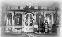 | Holy Resurrection Church | building | 1980 | 80000739 |
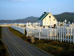 | St. Alexander Nevsky Chapel | building | 1980 | 80000738 |
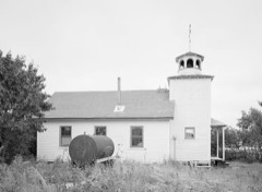 | St. Nicholas Chapel | building | 1980 | 80000742 |
Every wildfire the federal occurrence database records inside this county: 7 of them, burning about 85 acres. 1 started naturally and none was recorded as arson. Each settlement page carries the fires within five miles of it.
| Reported cause | Fires |
|---|---|
| Recreation and ceremony | 3 |
| Debris and open burning | 2 |
| Missing data/not specified/undetermined | 1 |
| Natural | 1 |
The five largest, by the area the report gives. None of them was recorded as arson.
| Date | Cause | Size | Reported by | Name on the report |
|---|---|---|---|---|
| 18 May 1996 | Recreation and ceremony | 30 acres | Alaska Fire Service | 604257 |
| 15 May 1992 | Recreation and ceremony | 30 acres | Alaska Fire Service | 204056 |
| 18 February 2018 | Debris and open burning | 18 acres | Alaska Fire Service | AKUTAN |
| 25 May 2010 | Natural | 3.5 acres | Alaska Fire Service | SAND POINT |
| 26 May 2010 | Recreation and ceremony | 3.0 acres | Alaska Fire Service | BEAVER BAY |
| 26 February 2018 | Debris and open burning | under an acre | Southwest Area | TRIDENT |
| 4 July 2019 | Missing data/not specified/undetermined | under an acre | Alaska State Office | UNGA ISLAND |
Every settlement page carries the fires within five miles of it - see the settlement index below.
The NOAA Storm Events Database holds 1 report for this county, causing no deaths, no injuries and no recorded property damage. Each settlement page carries the reports that name it.
| Kind of event | Reports |
|---|---|
| Tornado | 1 |
The most serious of them, by death, then injury, then recorded damage. The accounts are quoted exactly as the forecast office filed them.
| When | Event | Place named | Harm | What the report says |
|---|---|---|---|---|
| July 2005 | Tornado (F0) | Sand Point | - | Unstable conditions from Bristol bay extended out to the Alaska Peninsula Monday July 25th. Pictures from the public and discussions with the photographers confirmed the tornado did touch down several times and lifted debris from the ground. |
Named settlements recorded in the Geographic Names Information System, each with the topographic sheets covering it. Villages, hamlets and abandoned places alike. Each is shown with the nearest named watercourse or landform and the survey quadrangle it falls on.
Aleutians East census subarea · 99583 · Near Island Rock · False Pass D-5 SE quadrangle
9 sheets, 1949 to 1995
Aleutians East census subarea · Near Gull Island · Port Moller D-3 SE quadrangle
6 sheets, 1953 to 1988
Aleutians East census subarea · Near Baby Islands · Unalaska C-1 NE quadrangle
11 sheets, 1951 to 1989
No longer a settlement
Aleutians East census subarea · 99612 · Cold Bay A-1 SW quadrangle
12 sheets, 1943 to 1983
Aleutians East census subarea · Unimak B-3 NW quadrangle
9 sheets, 1951 to 1989
No longer a settlement
Aleutians East census subarea · Unimak C-3 NE quadrangle
9 sheets, 1951 to 1989
No longer a settlement
Aleutians East census subarea · Near Rabbit Island · False Pass B-3 NE quadrangle
9 sheets, 1949 to 1989
Aleutians East census subarea · 99661 · Near Range Island · Port Moller B-2 SE quadrangle
6 sheets, 1953 to 1988
Aleutians East census subarea · Unimak A-5 NE quadrangle
9 sheets, 1951 to 1989
No longer a settlement
Aleutians East census subarea · Near Bird Island · False Pass C-4 NW quadrangle
9 sheets, 1949 to 1989
No longer a settlement
Aleutians East census subarea · 99661 · Port Moller A-2 NW quadrangle
7 sheets, 1953 to 1988
No longer a settlement
Aleutians East census subarea · On Tigalda Island · Unimak A-4 SE quadrangle
9 sheets, 1951 to 1989
No longer a settlement
Aleutians East census subarea · On Unalga Island · Unalaska C-1 NW quadrangle
11 sheets, 1951 to 1989
No longer a settlement
Aleutians East census subarea · Chignik D-3 SW quadrangle
5 sheets, 1963
No longer a settlement
Aleutians East census subarea · 99661 · Near Flagstaff Hill · Port Moller A-2 NW quadrangle
7 sheets, 1953 to 1988
The vanished settlements of Aleutians East Borough: the places named above that are no longer on the map.