 Block
From the record
3 National Register listings published here.
Sources: the National Register database, National Park Service
21 topographic sheets cover 6 settlements here, and 3 properties are on the National Register of Historic Places.
3 National Register listings published here.
Sources: the National Register database, National Park Service
Every property in this county listed on the National Register of Historic Places, with the year it was listed and the federal nomination document.
| Photograph | Property | Type | Listed | Reference |
|---|---|---|---|---|
| APA's Diamond NN Cannery | district | 2021 | 100006826 | |
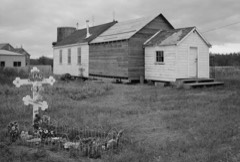 | Elevation of Holy Cross Church | building | 1980 | 80000755 |
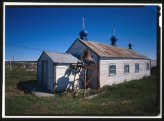 | St. John the Baptist Chapel | building | 1980 | 80000750 |
Every wildfire the federal occurrence database records inside this county: 12 of them, burning about 9,701 acres. 3 started naturally and none was recorded as arson. Each settlement page carries the fires within five miles of it.
| Reported cause | Fires |
|---|---|
| Missing data/not specified/undetermined | 5 |
| Natural | 3 |
| Recreation and ceremony | 2 |
| Equipment and vehicle use | 1 |
| Debris and open burning | 1 |
The five largest, by the area the report gives. None of them was recorded as arson.
| Date | Cause | Size | Reported by | Name on the report |
|---|---|---|---|---|
| 20 June 2015 | Natural | 6,760 acres | Southwest Area | COFFEE CREEK |
| 20 June 2015 | Natural | 2,519 acres | Alaska Fire Service | PAULS CREEK |
| 16 March 1997 | Missing data/not specified/undetermined | 300 acres | Alaska Fire Service | NAKNEK SOU |
| 21 July 1996 | Missing data/not specified/undetermined | 60 acres | Alaska Fire Service | 604660 |
| 25 August 2019 | Natural | 23 acres | Alaska State Office | PAULS CREEK |
| 5 July 2009 | Recreation and ceremony | 19 acres | Alaska Fire Service | NAKNEK |
| 30 May 2011 | Missing data/not specified/undetermined | 10 acres | Southwest Area | RAPIDS CAMP |
| 8 April 2008 | Missing data/not specified/undetermined | 5.0 acres | Alaska Fire Service | SAVONSKI |
Every settlement page carries the fires within five miles of it - see the settlement index below.
Named settlements recorded in the Geographic Names Information System, each with the topographic sheets covering it. Villages, hamlets and abandoned places alike. Each is shown with the nearest named watercourse or landform and the survey quadrangle it falls on.
Bristol Bay census subarea · 99613 · On Eskimo Creek · Naknek C-2 NW quadrangle
13 sheets, 1952 to 1964
Bristol Bay census subarea · On Graveyard Creek · Naknek D-4 SE quadrangle
14 sheets, 1952 to 1964
Bristol Bay census subarea · 99633 · On Packers Creek · Naknek C-4 NE quadrangle
13 sheets, 1952 to 1964
Bristol Bay census subarea · 99670 · By Kunsiniali Point · Naknek C-3 NW quadrangle
14 sheets, 1952 to 1964
Bristol Bay census subarea · 99670 · On Packers Creek · Naknek C-3 NW quadrangle
14 sheets, 1952 to 1964