 Block
From the record
12 National Register listings published here, 2 of them National Historic Landmarks.
Sources: the National Register database, National Park Service
160 topographic sheets cover 39 settlements here, and 12 properties are on the National Register of Historic Places.
12 National Register listings published here, 2 of them National Historic Landmarks.
Sources: the National Register database, National Park Service
Every property in this county listed on the National Register of Historic Places, with the year it was listed and the federal nomination document.
| Photograph | Property | Type | Listed | Reference |
|---|---|---|---|---|
| Agricultural Experiment Station Barn | building | 2004 | 04000716 | |
| American Cemetery | site | 1980 | 80004570 | |
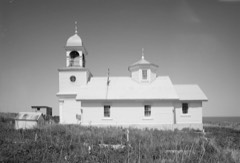 | Ascension of Our Lord Chapel | building | 1980 | 80004580 |
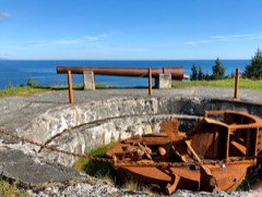 | Fort Abercrombie State Historic Site | site | 1970 | 70000917 |
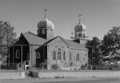 | Holy Resurrection Church | building | 1977 | 77001574 |
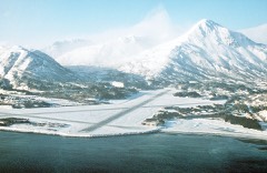 | Kodiak Naval Operating Base and Forts Greely and Abercrombie | site | 1985 | 85002731 |
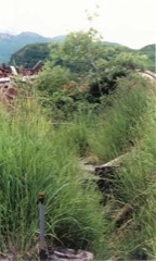 | Kukak Cannery Archeological Historic District | district | 2003 | 03000192 |
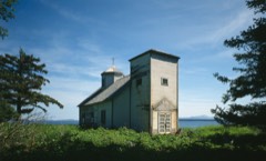 | Nativity of Holy Theolokos Church | building | 1980 | 80004577 |
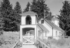 | Nativity of Our Lord Chapel | building | 1980 | 80004582 |
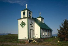 | Protection of the Theotokos Chapel | building | 1980 | 80004590 |
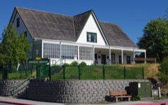 | Russian-American Company Magazin | building | 1966 | 66000954 |
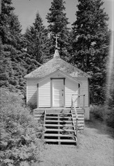 | Sts. Sergius and Herman of Valaam Chapel | building | 1980 | 80004581 |
Every wildfire the federal occurrence database records inside this county: 89 of them, burning about 27,712 acres. 1 started naturally and 3 were recorded as arson. Each settlement page carries the fires within five miles of it.
| Reported cause | Fires |
|---|---|
| Recreation and ceremony | 20 |
| Missing data/not specified/undetermined | 18 |
| Debris and open burning | 16 |
| Smoking | 9 |
| Misuse of fire by a minor | 7 |
| Fireworks | 6 |
| Equipment and vehicle use | 5 |
| Arson/incendiarism | 3 |
| Power generation/transmission/distribution | 2 |
| Other causes | 1 |
| Firearms and explosives use | 1 |
| Natural | 1 |
The five largest, by the area the report gives. None of them was recorded as arson.
| Date | Cause | Size | Reported by | Name on the report |
|---|---|---|---|---|
| 16 April 1997 | Missing data/not specified/undetermined | 14,100 acres | Alaska Fire Service | MOSER BAY |
| 27 August 2015 | Power generation/transmission/distribution | 4,862 acres | Alaska Fire Service | TWIN CREEKS |
| 13 October 1996 | Recreation and ceremony | 3,250 acres | Alaska Fire Service | 603749 |
| 11 May 1996 | Smoking | 1,200 acres | Alaska Fire Service | 603158 |
| 6 May 2000 | Recreation and ceremony | 700 acres | Alaska Fire Service | FRAZER LK |
| 2 May 2002 | Recreation and ceremony | 650 acres | Alaska Fire Service | KAGUYAK |
| 6 April 2002 | Recreation and ceremony | 595 acres | Alaska Fire Service | CHIP COVE |
| 9 May 1996 | Recreation and ceremony | 500 acres | Kenai-Kodiak Area | SHED FIRE |
Every settlement page carries the fires within five miles of it - see the settlement index below.
The NOAA Storm Events Database holds 2 reports for this county, causing no deaths, no injuries and no recorded property damage. Each settlement page carries the reports that name it.
| Kind of event | Reports |
|---|---|
| Heavy Rain | 1 |
| Flood | 1 |
The most serious of them, by death, then injury, then recorded damage. The accounts are quoted exactly as the forecast office filed them.
| When | Event | Place named | Harm | What the report says |
|---|---|---|---|---|
| December 2024 | Flood | Kodiak | - | Kodiak Airport reported 4.27 inches of rain which drove area rivers up, and flooded low lying roads, ditches and areas with poor drainage. The Terror River crested at 5.26 ft at 10:30PM AKST; this is 0.26 ft above minor flood stage. |
| October 2019 | Heavy Rain | Kodiak | - | Heavy rainfall caused erosion and mudslides along the Chiniak Highway. Some parts of the road were washed out. |
Named settlements recorded in the Geographic Names Information System, each with the topographic sheets covering it. Villages, hamlets and abandoned places alike. Each is shown with the nearest named watercourse or landform and the survey quadrangle it falls on.
Kodiak Island census subarea · 99615 · Near Round Hill · Trinity Islands D-1 NW quadrangle
12 sheets, 1951 to 1954
Kodiak Island census subarea · Near Bird Island · Kodiak D-2 SE quadrangle
21 sheets, 1949 to 1987
Kodiak Island census subarea · 99615 · Afognak A-3 SE quadrangle
15 sheets, 1952 to 1954
Kodiak Island census subarea · Near Ugak Island · Kodiak C-1 NW quadrangle
18 sheets, 1949 to 1987
Kodiak Island census subarea · 99615 · On Chiniak River · Kodiak C-1 SW quadrangle
18 sheets, 1949 to 1987
No longer a settlement
Kodiak Island census subarea · 99615 · Afognak A-2 SW quadrangle
13 sheets, 1952 to 1954
Kodiak Island census subarea · Kodiak B-3 NE quadrangle
17 sheets, 1949 to 1952
No longer a settlement
Kodiak Island census subarea · 99615 · Near Inner Seal Rock · Karluk B-3 SE quadrangle
12 sheets, 1951 to 1964
No longer a settlement
Kodiak Island census subarea · Afognak C-6 SW quadrangle
12 sheets, 1951 to 1952
No longer a settlement
Kodiak Island census subarea · 99608 · On Karluk River · Karluk C-2 SE quadrangle
13 sheets, 1951 to 1964
Kodiak Island census subarea · Mount Katmai A-3 SW quadrangle
15 sheets, 1948 to 1964
No longer a settlement
Kodiak Island census subarea · 99615 · Kodiak B-3 SE quadrangle
17 sheets, 1949 to 1952
No longer a settlement
Kodiak Island census subarea · 99615 · Near Near Island · Kodiak D-2 SE quadrangle
21 sheets, 1949 to 1987
Kodiak Island census subarea · Near Aguligik Island · Mount Katmai B-1 SW quadrangle
16 sheets, 1948 to 1964
Kodiak Island census subarea · Near Sitkalidak Island · Kodiak A-4 NW quadrangle
14 sheets, 1952 to 1954
No longer a settlement
Kodiak Island census subarea · Kodiak A-5 SW quadrangle
14 sheets, 1952 to 1954
No longer a settlement
Kodiak Island census subarea · Kodiak A-3 NW quadrangle
16 sheets, 1949 to 1952
No longer a settlement
Kodiak Island census subarea · 99644 · Near Prokoda Island · Kodiak D-2 NW quadrangle
19 sheets, 1949 to 1952
Kodiak Island census subarea · 99644 · Near Eider Island · Kodiak D-2 NE quadrangle
19 sheets, 1949 to 1952
No longer a settlement
Kodiak Island census subarea · On Fugitive Creek · Kodiak A-4 NE quadrangle
14 sheets, 1952 to 1954
Kodiak Island census subarea · 99615 · Near Sheep Island · Kodiak C-4 NW quadrangle
17 sheets, 1952 to 1954
Kodiak Island census subarea · 99615 · Afognak A-4 SE quadrangle
14 sheets, 1952 to 1953
Kodiak Island census subarea · 99615 · Kodiak A-6 SW quadrangle
25 sheets, 1951 to 1954
No longer a settlement
Kodiak Island census subarea · 99615 · Kodiak B-2 NW quadrangle
18 sheets, 1949 to 1952
No longer a settlement
Kodiak Island census subarea · 99643 · Kodiak A-5 NE quadrangle
14 sheets, 1952 to 1954
No longer a settlement
Kodiak Island census subarea · Near Harvester Island · Kodiak C-6 NW quadrangle
16 sheets, 1952 to 1954
Kodiak Island census subarea · 99644 · Near Nelson Island · Kodiak D-2 NE quadrangle
19 sheets, 1949 to 1952
No longer a settlement
The vanished settlements of Kodiak Island Borough: the places named above that are no longer on the map.