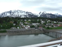
Listed on the National Register of Historic Places in 1980.
From the record
“The Government Indian School, also known as the B.I.A. School and later the City Multipurpose Building, is a historic school building in Haines, Alaska.”
Wikipedia article Government Indian School, CC BY-SA 4.0.
One of 5 National Register listings published here for Haines Borough · listed in 1980 · category: Building.
National Register reference number.80000756- the number the National Park Service assigned this property when it was listed, and the key its nomination file is catalogued under at the National Archives.
Fires near this property
52 since 1992
Regional context, not property-specific
evidence. The
federal wildfire occurrence database
lists 52 fires within 5 miles of Government Indian School
between 1992 and 2014, burning about 19 acres in total. 2 started naturally. None was recorded as arson.
Distance is straight-line from the map coordinates, so a fire counted
here may appear on a neighbouring settlement's page as well.
Reported cause
Fires
Debris and open burning
20
Recreation and ceremony
17
Fireworks
6
Missing data/not specified/undetermined
4
Smoking
2
Natural
2
Equipment and vehicle use
1
The most recent of
them, most recent first, with the day each was reported and the service
that recorded it.
Regional context, not property-specific
evidence. The federal mineral resources record lists
11 workings within 5 miles of Government Indian School: 7 prospects, 3 past producers, 1 occurrence.
None of them still produces. What was taken out: Gold, Copper, Iron, Sand and Gravel, Construction. Distance is straight-line from the
map coordinates, so a quarry counted here may appear on a neighbouring
settlement's page as well.
Regional context, not property-specific
evidence. The National Weather Service names
Haines, the town this property stands in, in 1 storm report in 2020: 1 debris flow.
The reports record 2 deaths. Each account below is quoted exactly as the forecast office
filed it, from the NOAA Storm Events Database, and each date
opens the federal record of that event.
As the atmospheric river moved over the far north central inner channels of Southeast Alaska it produced significant amount of precipitation from December 1st-2nd. Heavy to moderate rainfall persisted over 48 hours with the highest amounts coming during the afternoon hours of December 1 through late morning of December 2nd. By mid morning on December 1st, near 2 of precipitation already fell. The snow levels were low at the start of the event with a few inches at sea level in Haines but as much as 12 was reported at 800 feet by the Haines40NW COOP and 20 at the 2500 foot Flower Mt SNOTEL site by the morning of December 1st. Closer to Haines, the Ripinski ridge weather station at 2560 feet reported an estimated snow accumulation of near 59 from before the warm air moved into the area. The snow level rose rapidly through the evening of December 1st to be above the mountain tops by the early morning hours of December 2nd. This warming at elevation melted the fresh snow that fell with Ripinkis Ridge losing close to 30 and Flower Mt losing near 20 by the afternoon of December 2nd. By the end of December 1st the Haines airport reported a 24 hour precipitation amount of 5.49 which was a 25 to 50 year event and broke the all time daily precipitation record from 1946. The Haines COOP reported at 7am AKST on December 2nd a 24 hour amount of 6.62 which also broke the all time daily precipitation record from 2005. Haines40NW COOP along the Haines Hwy reported at 7am AKST on December 2nd a 24 hour precipitation amount of 5.23 a new all time daily precipitation record beating out 1999 and a 25 year event. From December 1st to the 2nd precipitation amounts from the downtown Haines COOP were 8.54, Haines Airport 10.26 a 200-500 year event, and the Haines40NW COOP 8.12 a 50-100 year event, were all time 48 hours precipitation records. From December 1st to 3rd 10 to 10.50 of precipitation fell from downtown Haines to the Haines border with a 100 to 200 year event. All of this heavy rainfall and snow melt produced significant impacts in the Haines area. In the early hours of December 2 after all-time record rainfall, saturated soils, and a deep snowpack, a second impulse of heavy precipitation moved over the area, and the snow level rose above 2500ft. The rising snow level began to melt the fresh snowfall at high elevation to produce significant amount of runoff that overwhelmed drainage ditches and culverts. The intense runoff began to erode the roads at the base of Ripinski Ridge and by day break there was significant infrastructure damage to all roads near Ripinski ridge which left Piedad Rd, Cathedral View Dr, Allen Rd, Comstock Rd, 4th ave,Young Rd to name a few that were impassable as the roads were washed away from erosion. There was also significant flooding away from the steep terrain from poor drainage not keeping up with the amount of runoff. Up to 4 feet of water flooded the Haines Hitch-Up RV park along with flooding across places at the Haines airport essentially closing it down to flights. To go along with the major road infrastructure damage there were a number significant major debris flows from the intense precipitation, super saturated soils and strong winds to help trigger the slides that blocked roads and damaged homes near steep terrain. Haines was cut off from the Canadian Border and the airport due to debris flows blocking the Haines Hwy. There were also multiple debris flows along Lutak Rd that damaged the Lutak fuel Dock, blocked the road in multiple locations and isolated residence in a subdivision at the end of the road. A few homes at the end of Lutak Rd we significantly damaged from debris flows coming down behind their homes with one getting pushed off its foundation, another with debris in the house and another with minor damage. Mud Bay Rd was blocked by a debris flow which isolated another part of town. A large avalanche came down into Chilkat Lake out the Haines Hwy that damaged a few homes. Residence in the affected areas and other locations near steep terrain were evacuated to emergency shelters throughout the morning of December 2. Heavy rain continued into the afternoon hours and around 130pm AKST a massive landslide occurred along Beach Rd that took out a 200 yard section of the road, destroyed 2 homes while causing major damage to another. One of the destroyed homes was not occupied but the other had to 2 people inside. The 2 people perished from the landslide or what the geologist are calling a geologic mass wasting event. There were about a half dozen homes on the south side of the slide that were evacuated due to the threat of another very large landside. It continued to be very wet with freezing levels going up and down to keep increase runoff not just from the precipitation but also from snow melt for the next week with a 7 day total of 14.85 which is a near 150 year event. The continue precipitation on the super saturated soils kept the threat of more debris flows high through December 7th. There was some minor movements of a home near an old landslide from 2012 called the slump area. This was one of the most impactful flooding and debris flow event since 2005 or ever and the data backups extreme impacts. The city of Haines declared a disaster for this event from the widespread and extensive infrastructure damage, 2 homes destroyed, 7 homes with major damage, 16 homes with minor damage with another 12 home adversely affected from the area damage and the 2 deaths. The governor of Alaska also declared a disaster emergency for Southeast Alaska from the impacts of this event.
No historic map-sheet match is published
for this property yet. That does not mean no map exists. This record needs
a coordinate-quality review before it can be joined to a sheet boundary.
Browse the county's mapped places while that work is
pending.
Listed places nearby
2 within 8 miles
Other National Register properties close
enough to walk or drive between, ordered by distance from this one. Both
positions come from the same geocoding pass that matched these properties
to their map sheets.
Listing record. National Park Service National Register of Historic Places, listed-properties dataset, current to 2026-05-22.
Map join. Address geocoded through the United States Census geocoder, then tested against the published boundary of every sheet in the USGS Historical Topographic Map Collection.
How this page is made. Listing fields come from federal records; map-sheet coverage is a labelled coordinate-to-boundary calculation, not a source-field claim.
Wildfire. Short, Karen C. 2022. Spatial wildfire occurrence data for the United States, 1992-2020 [FPA_FOD_20221014]. 6th Edition. Fort Collins, CO: Forest Service Research Data Archive. https://doi.org/10.2737/RDS-2013-0009.6 Collected with United States Government funding and usable without additional permissions or fees.
Mines and quarries. USGS Mineral Resources Data System (MRDS) https://mrdata.usgs.gov/mrds/ A work of the United States government, no copyright under 17 U.S.C. 105.
Storms. NOAA National Centers for Environmental Information, Storm Events Database https://www.ncei.noaa.gov/stormevents/ A work of the United States government, no copyright under 17 U.S.C. 105. Narratives are quoted verbatim from the National Weather Service report and are not edited or summarised.
 Block