 Block
From the record
11 National Register listings published here, 1 of them a National Historic Landmark.
Sources: the National Register database, National Park Service
70 topographic sheets cover 55 settlements here, and 11 properties are on the National Register of Historic Places.
11 National Register listings published here, 1 of them a National Historic Landmark.
Sources: the National Register database, National Park Service
Every property in this county listed on the National Register of Historic Places, with the year it was listed and the federal nomination document.
| Photograph | Property | Type | Listed | Reference |
|---|---|---|---|---|
 | Elks Club | building | 1979 | 79000445 |
 | Gen. Robert E. Lee Monument | object | 1996 | 96000450 |
 | Lee County Courthouse | building | 1995 | 95001090 |
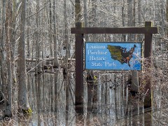 | Louisiana Purchase Survey Marker | site | 1972 | 72000206 |
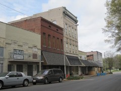 | Marianna Commercial Historic District | district | 2001 | 00001559 |
 | Marianna Missouri-Pacific Depot | building | 1994 | 94000827 |
 | Marianna National Guard Armory | building | 2007 | 06001267 |
 | Marianna Waterworks | building | 2007 | 06001281 |
 | McClintock House | building | 1982 | 82000857 |
 | McClintock House | building | 1977 | 77000261 |
 | John A. Plummer House | building | 1998 | 98000646 |
Every wildfire the federal occurrence database records inside this county: 37 of them, burning about 350 acres. 1 started naturally and 8 were recorded as arson. Each settlement page carries the fires within five miles of it.
| Reported cause | Fires |
|---|---|
| Debris and open burning | 14 |
| Arson/incendiarism | 8 |
| Missing data/not specified/undetermined | 8 |
| Recreation and ceremony | 2 |
| Power generation/transmission/distribution | 2 |
| Equipment and vehicle use | 2 |
| Natural | 1 |
The five largest, by the area the report gives. Three of them were set deliberately.
| Date | Cause | Size | Reported by | Name on the report |
|---|---|---|---|---|
| 18 March 1999 | Arson/incendiarism | 90 acres | Ozark-St. Francis National Forests | TWO STORY |
| 26 June 1998 | Debris and open burning | 51 acres | Arkansas Forestry Commission | not named |
| 4 March 2006 | Arson/incendiarism | 35 acres | Ozark-St. Francis National Forests | THIRD FIRE |
| 7 April 2006 | Debris and open burning | 33 acres | Arkansas Forestry Commission | not named |
| 29 October 2000 | Debris and open burning | 27 acres | Arkansas Forestry Commission | not named |
| 29 October 2000 | Arson/incendiarism | 20 acres | Arkansas Forestry Commission | not named |
| 12 March 2007 | Debris and open burning | 15 acres | Ozark-St. Francis National Forests | WEBB |
| 9 October 2010 | Missing data/not specified/undetermined | 10 acres | Ozark-St. Francis National Forests | ARCHIE |
Every settlement page carries the fires within five miles of it - see the settlement index below.
The NOAA Storm Events Database holds 123 reports for this county, causing 1 death, 29 injuries and about $4,447,980 in recorded property damage. Each settlement page carries the reports that name it.
| Kind of event | Reports |
|---|---|
| Thunderstorm Wind | 60 |
| Hail | 34 |
| Tornado | 13 |
| Flash Flood | 9 |
| Flood | 7 |
The most serious of them, by death, then injury, then recorded damage. The accounts are quoted exactly as the forecast office filed them.
| When | Event | Place named | Harm | What the report says |
|---|---|---|---|---|
| July 2000 | Thunderstorm Wind | Marianna | 1 killed, $5,000 | A tree was blown over and fell on a car killing the driver. Other trees and power lines were knocked down. |
| November 1970 | Tornado (F3) | not stated | 27 hurt, $250,000 | no account filed |
| November 1973 | Tornado (F2) | not stated | 1 hurt, $250,000 | no account filed |
| April 2011 | Thunderstorm Wind | Marianna Lee Co Arpt | 1 hurt | Straight line winds damaged two businesses along Main Street in Marianna. In addition, a structure at the Witten Elementary School sustained major damage. Multiple trees and power lines blocked Highway 1 South as well as numerous city streets. As a result of the storm, 5000 people were without power and one injury occurred. Multiple trees were also knocked down along county roads outside Marianna including County Road 415. |
| December 1978 | Tornado (F2) | not stated | $2,500,000 | no account filed |
| May 2011 | Flood | Jocks | $550,000 | Heavy rain during late April into early May caused the St. Francis River and L'Anguille River to rise to near record levels. The river remained above flood stage through the end of May. Several homes sustained minor damage from the flooding. Several roads were closed and/or damaged. Several hundred acres of cropland was flooded. The Mississippi River was also at near record levels. Backwater from the Mississippi River aggravated flooding further on the St. Francis River and L'Anguille River. |
| November 1983 | Tornado (F1) | not stated | $250,000 | no account filed |
| December 2015 | Tornado (EF2) | Scott Vly | $100,000 | This tornado damaged several mobile homes and caused roof damage to several permanent homes. The tornado damaged boat docks along Bear Creek Lake before dissipating. |
| March 2023 | Thunderstorm Wind | Scott Vly | $50,000 | Straight-line winds punched in a grain silo on Highway 1 South about five miles south of Marianna. |
| December 2015 | Tornado (EF2) | Aubrey | $50,000 | A tornado touched down southwest of Marianna. A mobile home was destroyed. There was roof damage to homes. |
| June 1994 | Thunderstorm Wind | Aubrey | $50,000 | Thunderstorm winds blew the roof off a house. Four people were trapped in the debris. |
| May 2024 | Thunderstorm Wind | Marianna | $25,000 | Roof partially peeled off of a retail building on Chestnut Street. |
| April 2024 | Thunderstorm Wind | Scott Vly | $25,000 | The roof was removed from a home on Highway 1 south of Marianna. |
| March 2020 | Flash Flood | La Grange | $25,000 | Lee County Road 215 closed due to a washout between County Road 242 and County Road 248. |
| June 2018 | Thunderstorm Wind | Felton | $25,000 | Lots of large trees down along Highway 79 in and around the city of Marianna. |
| January 1982 | Tornado (F0) | not stated | $25,000 | no account filed |
| December 1982 | Tornado (F0) | not stated | $25,000 | no account filed |
| February 1975 | Tornado (F1) | not stated | $25,000 | no account filed |
| May 2024 | Thunderstorm Wind | Marianna | $20,000 | Power poles knocked down between Brickeys and Marianna. |
| June 1998 | Thunderstorm Wind | Marianna | $20,000 | Trees and power lines were knocked down in both Marianna and Aubrey. |
| July 1997 | Thunderstorm Wind | Marianna | $15,000 | Three homes suffered minor damage. A large door on a farm shop was blown in. A small storage building overturned and rolled. Some farm equipment was moved around. Some trees and power lines were knocked down as well. |
| January 2024 | Thunderstorm Wind | South Plains | $10,000 | Part of a roof was lifted off a home and several trees were downed in Moro. |
| January 2024 | Thunderstorm Wind | Felton | $10,000 | Part of a roof was blown off near the intersection of highway 243 and county road 402. |
| March 2022 | Thunderstorm Wind | Marianna | $10,000 | Several broken utility poles on Chestnut Street in Marianna. |
| January 2020 | Thunderstorm Wind | Council | $10,000 | Straight-line winds caused significant damage to a mobile home at Midway Lake. |
| December 2009 | Flash Flood | Gill | $10,000 | Heavy rain produced flash flooding in and around Lee County. Highway 121 near Aubrey, Highway 261 near Gill and Highway 238 in Rondo were flooded as a result. |
| April 2008 | Thunderstorm Wind | Marianna | $10,000 | Straight line winds damaged trailers and knocked down trees along Highway 1, just south of Marianna. |
| December 2002 | Tornado (F0) | Aubrey | $10,000 | A tornado briefly touched down in Aubrey which produced some property damage. |
| May 2004 | Thunderstorm Wind | Moro | $5,000 | Several trees were blown down. |
| July 2004 | Thunderstorm Wind | Marianna | $5,000 | Several power lines were knocked down. |
| May 2003 | Thunderstorm Wind | Haynes | $5,000 | Several trees were knocked down. |
| March 2001 | Thunderstorm Wind | Rondo | $5,000 | A few trees were snapped. |
| May 1999 | Thunderstorm Wind | Brickeys | $5,000 | A few power lines were knocked down. |
| July 1995 | Thunderstorm Wind | Marianna | $5,000 | Some trees and power lines were blown down. |
| November 1995 | Thunderstorm Wind | Southern Part | $5,000 | Several trees and power lines were blown down. |
| June 1994 | Thunderstorm Wind | Marianna | $5,000 | Thunderstorm winds knocked down some trees and blew a car off the road. |
| May 1993 | Thunderstorm Wind | Haynes | $5,000 | Thunderstorm winds blew down some of the tops of large trees. |
| May 1993 | Thunderstorm Wind | Soudan | $5,000 | Thunderstorm winds knocked down some tree limbs and several large trees. |
| August 1993 | Thunderstorm Wind | Moro | $5,000 | A few power lines were knocked down. |
| June 2008 | Thunderstorm Wind | Marianna | $4,000 | Straight line winds blew several trees and power lines down in Marianna. |
| May 2008 | Thunderstorm Wind | Haynes | $4,000 | Straight line winds blew trees and power lines down in Haynes. |
| August 2007 | Thunderstorm Wind | Turkey Scratch | $4,000 | Trees were knocked down into power lines in the Turkey Scratch area from straight line winds. |
| April 2025 | Thunderstorm Wind | Moro | $3,000 | Several trees downed and uprooted along Hwy 238 south of Moro. |
| April 1973 | Tornado (F1) | not stated | $2,500 | no account filed |
| March 2008 | Thunderstorm Wind | Tongin | $2,000 | Straight line winds broke several large branches off several trees in Brickeys. |
| April 2008 | Hail | Marianna | $2,000 | Quarter hail fell along Highway 79, 5 miles west of Marianna. |
| June 1997 | Thunderstorm Wind | Moro | $2,000 | A couple of trees were knocked down. |
| May 1996 | Thunderstorm Wind | Marianna | $2,000 | no account filed |
| October 1996 | Thunderstorm Wind | New Salem | $2,000 | no account filed |
| October 2009 | Flash Flood | Marianna | $1,000 | Several streets were flooded in the downtown section of Marianna. |
| February 2008 | Tornado (EF0) | Bemis Plantation | $1,000 | A weak tornado touched down in an open field near Highway 79 just northeast of Monroe, Arkansas. One tree was snapped off. |
| July 2005 | Thunderstorm Wind | Aubrey | $1,000 | A couple of trees were blown down. |
| March 2008 | Hail | Marianna | $1,000 | no account filed |
| April 2007 | Hail | Marianna | $1,000 | no account filed |
| May 2007 | Hail | Marianna | $1,000 | no account filed |
| April 2006 | Hail | Marianna | $1,000 | no account filed |
| April 2003 | Hail | Moro | $750 | no account filed |
| May 2003 | Hail | Garret | $750 | no account filed |
| March 2001 | Hail | Aubrey | $600 | Hail ranged in size from dimes to walnuts. |
| May 2006 | Thunderstorm Wind | Moro | $500 | A few trees were knocked down on Highway 78. |
The Survey's mineral resources record lists 2 workings inside this county. 1 still produces and 1 is closed or unrecorded. Each settlement page carries the workings within five miles of it.
| Commodity | Workings |
|---|---|
| Sand and Gravel, Construction, Stone, Crushed/Broken | 1 |
| Clay | 1 |
The least common of them first, because a county's hundredth gravel pit says nothing its first ten did not.
Named settlements recorded in the Geographic Names Information System, each with the topographic sheets covering it. Villages, hamlets and abandoned places alike. Each is shown with the nearest named watercourse or landform and the survey quadrangle it falls on.
St. Francis township · 72320 · Brickeys quadrangle
18 sheets, 1939 to 1990
No longer a settlement
Spring Creek township · 72360 · On Spring Creek · Aubrey quadrangle
12 sheets, 1940 to 1990
Spring Creek township · 72360 · On Cat Creek · Rondo quadrangle
12 sheets, 1940 to 1990
No longer a settlement
Independence township · 72360 · On Mossy Lake Bayou · Soudan quadrangle
17 sheets, 1939 to 1990
Independence township · 72360 · On Bear Creek · La Grange quadrangle
16 sheets, 1939 to 1990
St. Francis township · 72320 · Near Whitehall Crevasse · Brickeys quadrangle
18 sheets, 1939 to 1990
No longer a settlement
Hampton township · 72368 · Garrett Grove quadrangle
15 sheets, 1940 to 1990
No longer a settlement
St. Francis township · 72320 · On North Alligator Bayou · Brickeys quadrangle
18 sheets, 1939 to 1990
Hardy township · 72360 · Near Morrells Hill · La Grange quadrangle
16 sheets, 1939 to 1990
St. Francis township · 72320 · On North Alligator Bayou · Brickeys quadrangle
18 sheets, 1939 to 1990
St. Francis township · 72320 · On Raft Bayou · Brickeys quadrangle
18 sheets, 1939 to 1990
Spring Creek township · 72360 · On Cat Creek · Aubrey quadrangle
12 sheets, 1940 to 1990
St. Francis township · 72360 · On North Alligator Bayou · Brickeys quadrangle
18 sheets, 1939 to 1990
Union township · 72360 · On Holcomb Bayou · Soudan quadrangle
17 sheets, 1939 to 1990
The vanished settlements of Lee County: the places named above that are no longer on the map.