 Block
From the record
13 National Register listings published here.
Sources: the National Register database, National Park Service
60 topographic sheets cover 49 settlements here, and 13 properties are on the National Register of Historic Places.
13 National Register listings published here.
Sources: the National Register database, National Park Service
Every property in this county listed on the National Register of Historic Places, with the year it was listed and the federal nomination document.
| Photograph | Property | Type | Listed | Reference |
|---|---|---|---|---|
| CCC Company 741 Powder Magazine Historic District | structure | 2007 | 07000201 | |
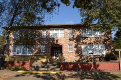 | Caddo Valley Academy Complex | district | 2002 | 02000485 |
| Cogburn Dipping Vat | structure | 2006 | 06000467 | |
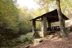 | Collier Springs Shelter | building | 1993 | 93001083 |
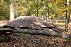 | Crystal Springs Camp Shelter | building | 1993 | 93001087 |
| Crystal Springs Dam | structure | 1993 | 93001088 | |
| Guinn Dipping Vat | structure | 2006 | 06000465 | |
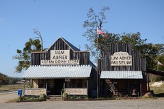 | Huddleston Store and McKinzie Store | building | 1984 | 84000007 |
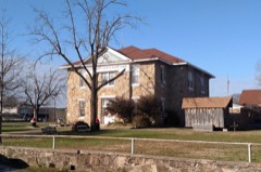 | Montgomery County Courthouse | building | 1976 | 76000441 |
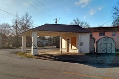 | Mount Ida Cities Service Filling Station | building | 2001 | 01001230 |
 | Norman Town Square | site | 1993 | 93000092 |
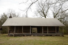 | Reeves-Melson House | building | 1985 | 85003069 |
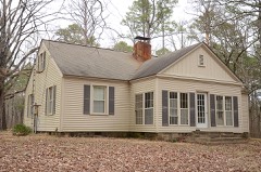 | Womble District Administration House No. 1 | building | 1993 | 93001101 |
Every wildfire the federal occurrence database records inside this county: 631 of them, burning about 26,416 acres. 125 started naturally and 199 were recorded as arson. Each settlement page carries the fires within five miles of it.
| Reported cause | Fires |
|---|---|
| Arson/incendiarism | 199 |
| Debris and open burning | 127 |
| Natural | 125 |
| Missing data/not specified/undetermined | 97 |
| Equipment and vehicle use | 31 |
| Recreation and ceremony | 24 |
| Power generation/transmission/distribution | 14 |
| Smoking | 7 |
| Fireworks | 3 |
| Misuse of fire by a minor | 3 |
| Railroad operations and maintenance | 1 |
The five largest, by the area the report gives. Two of them were set deliberately.
| Date | Cause | Size | Reported by | Name on the report |
|---|---|---|---|---|
| 13 March 2006 | Natural | 8,294 acres | Ouachita National Forest | NO MANS LAND |
| 26 June 2006 | Natural | 3,739 acres | Ouachita National Forest | SULPHUR MOUNTAIN |
| 1 April 2003 | Missing data/not specified/undetermined | 1,550 acres | Ouachita National Forest | BLAYLOCK MOUNTAIN |
| 29 July 2011 | Natural | 1,535 acres | Ouachita National Forest | HIGH PEAK |
| 12 February 2015 | Arson/incendiarism | 960 acres | Ouachita National Forest | WOLF MOUNTAIN |
| 12 March 2004 | Arson/incendiarism | 933 acres | Ouachita National Forest | POLK CREEK MOUNTAIN |
| 14 September 2011 | Natural | 705 acres | Ouachita National Forest | CHRISOPHER MOUNTAIN |
| 19 June 2012 | Natural | 685 acres | Ouachita National Forest | SHELTERWOOD 149 |
Every settlement page carries the fires within five miles of it - see the settlement index below.
The NOAA Storm Events Database holds 454 reports for this county, causing 20 deaths, 34 injuries and about $13,090,250 in recorded property damage. Each settlement page carries the reports that name it.
| Kind of event | Reports |
|---|---|
| Thunderstorm Wind | 191 |
| Hail | 151 |
| Flash Flood | 62 |
| Heavy Rain | 25 |
| Tornado | 15 |
| Lightning | 4 |
| Flood | 4 |
| Funnel Cloud | 2 |
The most serious of them, by death, then injury, then recorded damage. The accounts are quoted exactly as the forecast office filed them.
| When | Event | Place named | Harm | What the report says |
|---|---|---|---|---|
| June 2010 | Flash Flood | Slatington | 20 killed, 24 hurt, $9,000,000 | Heavy rain fell on saturated ground during the wee hours of June 11th in an area characterized by steep terrain, limited access, and poor communications. Along the Little Missouri River, flash flooding developed rapidly at the Albert Pike Recreation Area in the Ouachita National Forest. The flood took 20 lives, injured 24, and necessitated the rescue of more than 60 people.||The nearest river gage indicated that flood waters rose more than 20 feet in 4 hours.||Motor homes, camping trailers, fifth-wheel trailers, tents, and people and their possessions were all caught up in the flood. Vehicles were washed downstream, asphalt was torn off roads, and boulders rolled down nearby steep hillsides.||An adjacent private campground, known as Camp Albert Pike, was flooded as well. Although no lives were lost there, cabins were destroyed along with additional vehicles, RVs, and camping trailers.||Aside from the flooding produced by the Little Missouri River, most of the creeks in the area overflowed their banks. Trees and other vegetation that had been mowed down by the swift water could be seen at a number of locations along Arkansas Highway 369. In addition, small rockslides occurred on several of the hills adjacent to the highway.||Flash flooding also occurred on the Caddo River around Caddo Gap. A cabin and canoe rental business had several cabins flooded, along with the office/bunkhouse building. One swift-water rescue of campers was necessary. Some cattle and horses were lost to the flooding.||On the Caddo River at Norman, several camping trailers were swept into the river. |
| May 2013 | Flash Flood | Pencil Bluff | 3 hurt, $500,000 | Brushy Creek washed a house off its foundation about 3.8 miles west-northwest of Pencil Bluff. The house finally stopped moving when it ran up against a tree line. The occupants of the house survived. U.S. 270 flooded near Pencil Bluff and Arkansas 8 flooded near Norman. Numerous county roads were flooded. For the 24-hour period ending at 7 AM on the 31st, Oden measured 6.13 inches of rain and Pine Ridge collected 5.98 inches. At the Mount Ida airport, rainfall on the 30th measured 3.42 inches, followed by another 1.43 inches on the 31st. Also at the Mount Ida airport on the 30th, 0.66 inch of rain fell in the 5-minute period ending at 6:53 PM CDT, 0.97 inch fell in the 10-minute period ending at 6:54 PM CDT, and 1.20 inches fell in the 15-minute period ending at 6:56 PM CDT. |
| May 2013 | Tornado (EF2) | Huddleston | 2 hurt, $250,000 | An EF2 tornado blew the roof off one house and damaged another. A number of outbuildings were damaged or destroyed. Numerous trees were uprooted or snapped off. Two people were injured. |
| June 1998 | Thunderstorm Wind | Joplin | 2 hurt | no account filed |
| November 1988 | Thunderstorm Wind | not stated | 2 hurt | no account filed |
| April 2007 | Thunderstorm Wind | Pine Ridge | 1 hurt | A large tree limb fell and injured a person. |
| April 2017 | Heavy Rain | Mt Ida | $1,000,000 | Several bridges and roads have been washed out. There was a mud slide on Manford Rd. between Norman and Caddo Gap. Rain measured was 5.75 inches. |
| May 2011 | Flood | Pencil Bluff | $750,000 | A Boy Scout troop, which had been cut off by flooding at the Albert Pike Recreation Area on the Little Missouri River on the 1st, was rescued by a National Guard helicopter on the morning of the 3rd. The six scouts and two adults were not injured. |
| April 2011 | Flood | Pencil Bluff | $250,000 | Widespread areal flooding occurred. |
| March 2016 | Tornado (EF1) | Joplin | $200,000 | There was significant damage to several boat docks at Mountain Harbor, with some trees and power lines blown down. Several homes were damaged, including a mobile home with substantial damage. |
| May 2015 | Flash Flood | Welsh | $100,000 | Three bridges were washed out, along with several county roads closed due to flash flooding. |
| April 2011 | Tornado (EF1) | Welsh | $100,000 | A tornado exited Clark County west-northwest of Elm and entered Montgomery County east-southeast of Welsh. In Montgomery County, the tornado knocked down trees, power lines, and power poles, took the roof off of a barn, and caused a tree to fall on a house. The tornado exited Montgomery County east-northeast of Welsh and entered Hot Spring County west-southwest of Bonnerdale. |
| September 2008 | Flash Flood | Pine Ridge | $100,000 | Flooding occurred across the county. |
| July 2016 | Thunderstorm Wind | Mt Ida | $90,000 | Significant wind damage in Mt. Ida. Numerous trees were down across town with several homes receiving damage by falling trees. Some roofs were peeled back by the wind. |
| June 2015 | Thunderstorm Wind | Joplin | $50,000 | Just north of Joplin, thunderstorm winds blew down trees onto cars and camping trailers at the Tompkins Bend Use Area. |
| April 2011 | Tornado (EF1) | Pine Ridge | $50,000 | This tornado exited Polk County east-northeast of Opal and entered Montgomery County southwest of Pine Ridge. In Montgomery County, numerous trees and some power lines were blown down. |
| September 2008 | Flash Flood | Pine Ridge | $50,000 | Approximately 5.5 inches of rain fell. Low water bridges and crossings were flooded. |
| May 2020 | Flash Flood | Norman | $40,000 | The Montgomery County Sheriff Office reported multiple tents and one vehicle were washed into the Caddo River near the town of Norman. All campers evacuated beforehand and there were no reports of injuries. |
| July 2018 | Thunderstorm Wind | Pine Ridge | $40,000 | A 40'X60' pole barn was blown down. |
| July 2014 | Thunderstorm Wind | Norman | $40,000 | Trees were blown down on Arkansas 8 near Norman. One of the trees fell on a car. No one was injured. |
| July 2014 | Thunderstorm Wind | Joplin | $30,000 | Trees were blown down on U.S. 270. One of the trees fell on a car. No one was injured. |
| October 2014 | Thunderstorm Wind | Mt Ida | $30,000 | Trees were blown down around Mount Ida and many other places in Montgomery County. |
| April 2014 | Thunderstorm Wind | Welsh | $25,000 | Numerous trees and some power lines were blown down in the area of U.S. 70. |
| April 2013 | Thunderstorm Wind | Welsh | $25,000 | Chicken houses were damaged and trees and power lines were blown down. |
| June 2013 | Flood | Washita | $25,000 | Large amounts of rain over the Ouachita River and its tributaries from May 30th through June 1st contributed to a large rise on Lake Ouachita. The lake rose 9 feet by June 3rd, followed by a slow fall. The lake did not return to its normal level until June 21st. Roads and campgrounds near the lake were submerged. Some gangways to boat docks also went under water, causing people to have to travel in boats to reach their boat docks. |
| May 2010 | Flash Flood | Sims | $25,000 | A motorist reported to the State Police that a 4-mile stretch of U.S. Highway 270 was under water in the vicinity of Blowout Mountain. A National Weather Service storm survey indicated that creeks went far out of their banks in the area north of Oden. |
| April 2008 | Flash Flood | Fancy Hill | $25,000 | Numerous roads across the county were flooded. |
| April 1989 | Tornado (F0) | not stated | $25,000 | no account filed |
| April 1960 | Tornado (F1) | not stated | $25,000 | no account filed |
| July 2023 | Thunderstorm Wind | Joplin | $20,000 | Part of the roof at the Mountain Harbor Resort Marina over the docks/boat slips was damaged. Winds estimated from radar were around 40 mph. |
| July 2011 | Thunderstorm Wind | Washita | $20,000 | Trees and power lines were blown down between Mount Ida and Story. |
| May 2013 | Tornado (EF1) | Cox Spgs | $15,000 | An EF1 tornado uprooted trees and blew down part of a hay barn. |
| April 2011 | Thunderstorm Wind | Welsh | $15,000 | A tree fell on a car. |
| April 2009 | Thunderstorm Wind | Welsh | $15,000 | A roof was blown off a house. |
| January 2018 | Thunderstorm Wind | Caddo Gap | $10,000 | An attached carport was destroyed. |
| October 2014 | Thunderstorm Wind | Welsh | $10,000 | Trees were blown down in the southeastern part of Montgomery County. |
| June 2013 | Flash Flood | Pencil Bluff | $10,000 | A car was washed into flood waters at Caddo Gap, but the motorist was able to reach safety. Arkansas 88 at Sims was closed. Brushy Creek flooded Brushy Rd. west-northwest of Pencil Bluff in the same area where Brushy Creek washed a house off its foundation early on the morning of May 31st. Several motorists were stranded at Albert Pike Recreation Area when the Little Missouri River flooded a low-water crossing. The motorists were in no danger but had to wait for water to recede before they could cross the river. In addition, a number of county roads were flooded. Three-day rainfall totals for May 30th through June 1st included 10.23 inches at Pine Ridge, 10.16 inches at Oden, 8.65 inches at Mount Ida, and 7.52 inches at Caddo Gap. |
| May 2013 | Thunderstorm Wind | Caddo Gap | $10,000 | Numerous trees were blown down. |
| May 2013 | Tornado (EF1) | Welsh | $10,000 | This tornado exited Clark County 3.2 miles west-northwest of Elm and entered Montgomery County 2.1 miles east-southeast of Welsh. In Montgomery County, trees were snapped off or uprooted. The tornado exited Montgomery County 4.2 miles east-northeast of Welsh and entered Hot Spring County 1.6 miles west of Bonnerdale. This is the third segment of a four-segment tornado. |
| April 2011 | Thunderstorm Wind | Story | $10,000 | Trees were blown down on Arkansas Highway 27. |
| May 2011 | Flash Flood | Albert | $10,000 | Flash flooding along the Little Missouri River at the Albert Pike Recreation Area trapped a Boy Scout troop, preventing them from returning on schedule. |
| August 2011 | Thunderstorm Wind | Oden | $10,000 | Trees were blown down and trampolines were blown up into trees. |
| April 2022 | Thunderstorm Wind | Silver | $5,000 | A tree fell on a car. |
| April 2018 | Thunderstorm Wind | Welsh | $5,000 | A tree was blown into an outbuilding. The roof of a barn was lifted, but not blown off. The tops of several trees were snapped. The damage survey was performed by the Montgomery County OES. |
| October 2014 | Thunderstorm Wind | Welsh | $5,000 | Power lines were blown down on U.S. 70. |
| May 2013 | Thunderstorm Wind | Sims | $5,000 | Trees were blown down on Arkansas 88. |
| January 2013 | Flash Flood | Hog Jaw | $5,000 | Creeks overflowed their banks. |
| June 2012 | Flash Flood | Mt Ida Bearce Arpt | $5,000 | Low water crossings were flooded around the Gap Creek and Hickory Nut Mountain Recreation Areas. The sheriff's office indicated rainfall in the area totaled around 4.5 inches. |
| August 2012 | Thunderstorm Wind | Mt Ida | $5,000 | Trees were blown down. |
| April 2011 | Flash Flood | Manfred | $5,000 | A state trooper observed water across Arkansas Highway 8 in three places near Caddo Gap. Water was about to enter a house. |
| August 2010 | Thunderstorm Wind | Sims | $5,000 | Several trees were blown down. |
| May 2010 | Thunderstorm Wind | Sims | $5,000 | Small trees and large limbs were blown down. |
| July 1994 | Thunderstorm Wind | Pine Ridge | $5,000 | Thunderstorm winds downed some trees and power lines. |
| June 1994 | Thunderstorm Wind | Pencil Bluff | $5,000 | Trees and power lines were blown down. |
| January 2007 | Flash Flood | Mt Ida | $2,500 | Heavy rains fell across portions of Montgomery County, flooding several secondary roads. |
| September 1970 | Tornado (F1) | not stated | $2,500 | no account filed |
| March 1964 | Tornado (F1) | not stated | $2,500 | no account filed |
| May 2021 | Thunderstorm Wind | Caddo Gap | $2,000 | Shingles were blown off a roof and limbs were down. |
| October 2014 | Thunderstorm Wind | Hopper | $2,000 | A large tree was blown down east of Hopper. |
| February 2013 | Thunderstorm Wind | Caddo Gap | $2,000 | A tree fell across Arkansas 8. |
The Survey's mineral resources record lists 80 workings inside this county. 18 still produce and 62 are closed or unrecorded. Each settlement page carries the workings within five miles of it.
| Commodity | Workings |
|---|---|
| Quartz | 16 |
| Manganese | 14 |
| Sand and Gravel, Construction | 13 |
| Barium-Barite | 12 |
| Silica | 7 |
| Slate, Dimension | 4 |
| Stone, Crushed/Broken | 4 |
| Copper | 2 |
| Limestone, Dimension | 2 |
| Clay | 2 |
| Flagstone | 2 |
| Iron | 2 |
| Silver | 1 |
| Quartz, Stone, Crushed/Broken | 1 |
The least common of them first, because a county's hundredth gravel pit says nothing its first ten did not.
| Where | Site | Commodity | Status | Recorded |
|---|---|---|---|---|
| Donaghey Property | Silver | Unknown | ||
| Fisher Mountain Tract | Quartz, Stone, Crushed/Broken | Producer | 1946 | |
| Woodall Deposit | Phosphorus-Phosphates | Unknown | ||
| Glenwood | Clay | Past Producer | ||
| Hawkins Deposit | Iron | Unknown | ||
| Hendrickson Clay Deposit | Clay | Unknown | ||
| Lebow Copper Deposit | Copper, Iron | Unknown | ||
| Mauldin Pit | Flagstone | Producer | ||
| North Mountain Mine | Copper, Manganese | Past Producer | 1916 | |
| Unknown | Limestone, Dimension | Unknown | ||
| Unknown | Limestone, Dimension | Unknown | ||
| Unknown | Flagstone | Unknown | ||
| Bird & Son, Inc #1 | Stone, Crushed/Broken | Unknown | ||
| Bird & Son, Inc #2 | Stone, Crushed/Broken | Unknown | ||
| C.F. Saviac Quarry | Slate, Dimension | Unknown | ||
| Fisher Mt | Stone, Crushed/Broken | Past Producer | ||
| Glenwood #2 | Slate, Dimension | Producer | ||
| Glenwood Quarry & Plant | Stone, Crushed/Broken | Producer | ||
| Unknown | Slate, Dimension | Unknown | ||
| Unknown | Slate, Dimension | Unknown | ||
| Little Missouri | Silica | Unknown | ||
| Unknown | Silica | Unknown | ||
| Unknown | Silica | Unknown | ||
| Unknown | Silica | Unknown | ||
| Unknown | Silica | Unknown | ||
| Unknown | Silica | Unknown | ||
| Unknown | Silica | Unknown | ||
| Boone Springs Creek Prospect | Barium-Barite | Unknown | ||
| Cogburn Deposit | Barium-Barite | Past Producer | ||
| Dempsey Cogburn | Barium-Barite | Past Producer | ||
| Facy Hill | Barium-Barite | Producer | ||
| Fancy Hill | Barium-Barite | Unknown | Surface | |
| Gap Mountain Deposit | Barium-Barite | Past Producer | ||
| Hoyt-Williams Prospect | Barium-Barite | Unknown | ||
| Mc Knight Pit | Barium-Barite | Past Producer | 1945, 1978 | |
| Ouachita Nat. Forest | Barium-Barite | Unknown | ||
| Pigeon Roost Mountain Deposit | Barium-Barite | Past Producer | ||
| Polk Creek Mt Prospect | Barium-Barite, Manganese | Unknown | ||
| Sulfer Mountain Deposit | Barium-Barite | Past Producer | ||
| Abernathy Sand & Gravel Co | Sand and Gravel, Construction | Producer | ||
| Black Springs | Sand and Gravel, Construction | Producer | ||
| Dist 3 | Sand and Gravel, Construction | Past Producer | ||
| Montgomery County Pit | Sand and Gravel, Construction | Unknown | ||
| Oden | Sand and Gravel, Construction | Producer | ||
| Unknown Gravel Pit | Sand and Gravel, Construction | Unknown | ||
| Unknown Gravel Pit | Sand and Gravel, Construction | Unknown | ||
| Unknown Gravel Pit | Sand and Gravel, Construction | Unknown | ||
| Unknown Gravel Pit | Sand and Gravel, Construction | Unknown | ||
| Unknown Gravel Pit | Sand and Gravel, Construction | Unknown | ||
| Unknown Gravel Pit | Sand and Gravel, Construction | Unknown | ||
| Unknown Gravel Pit | Sand and Gravel, Construction | Unknown | ||
| Unknown Gravel Pit | Sand and Gravel, Construction | Unknown | ||
| Hendriksen Sample | Manganese | Unknown | ||
| Jones Valley Mine | Manganese | Unknown | ||
| Monroe-Knold Mine | Manganese | Unknown | ||
| Nelson Mine | Manganese | Past Producer | 1915 | |
| Plemmons Prospect | Manganese | Unknown | ||
| Robert Porter Prospect | Manganese | Prospect | 1916 | |
| S A Hanna Prospect | Manganese | Prospect | 1909 | |
| Slatington Mountain Prospects | Manganese | Prospect | 1916 | |
| Sugartree Mountain | Manganese | Unknown | ||
| United Mineral Industries Property | Manganese | Unknown | ||
| Unknown | Manganese | Unknown | ||
| Willie Cogburn | Manganese | Unknown | ||
| Burch Lode Mine | Quartz | Producer | 1982 | |
| Chalybeates Springs Mine | Quartz | Unknown | ||
| Crystal Pyramid Mine | Quartz | Producer | 1986, 1987 | |
| Diamond Drill Carbon #3 | Quartz | Unknown | ||
| Fiddler's Ridge Crystal Mine | Quartz | Producer | 1986, 1989 | |
| Fisher Mountain Mine | Quartz | Producer | 1940 | |
| Forgotten Aye Mine | Quartz | Past Producer | 1986 | |
| George Shieffield No. 2 Mine | Quartz | Unknown | ||
| Kimes Crystal Area | Quartz | Unknown | ||
| Leatherhead Mine | Quartz | Producer | 1987, 1990 | |
| Magic Presance Mine | Quartz | Past Producer | 1986, 1987 | |
| Mcgrew Mine | Quartz | Producer | 1986, 1988 | |
| Oden Mine | Quartz | Producer | 1986 | |
| Robins Mine | Quartz | Producer | 1971, 1978 | |
| Starfire Mine | Quartz | Producer | 1990 | |
| Wegner Quartz Crystals | Quartz | Producer | 1986 |
Named settlements recorded in the Geographic Names Information System, each with the topographic sheets covering it. Villages, hamlets and abandoned places alike. Each is shown with the nearest named watercourse or landform and the survey quadrangle it falls on.
Black Springs township · 71960 · On Dry Fork · Polk Creek Mountain quadrangle
15 sheets, 1906 to 1986
Black Springs township · 71960 · On Nealy Branch · Norman quadrangle
16 sheets, 1906 to 1986
Caddo Gap township · 71935 · On Smith Creek · Caddo Gap quadrangle
16 sheets, 1906 to 1986
Black Springs township · 71960 · Near Bearden Mountain · Polk Creek Mountain quadrangle
15 sheets, 1906 to 1986
Mount Ida township · 71957 · McGraw Mountain quadrangle
14 sheets, 1890 to 1982
No longer a settlement
Black Springs township · 71957 · On North Fork South Fork Ouachita River · Oden quadrangle
15 sheets, 1890 to 1985
Caney township · 71943 · Near Nelson Mountain · Glenwood quadrangle
16 sheets, 1906 to 1986
No longer a settlement
Center township · 71957 · On Rogers Creek · Reed Mountain quadrangle
15 sheets, 1890 to 1986
Center township · 71957 · On Irons Creek · McGraw Mountain quadrangle
14 sheets, 1890 to 1982
Alamo township · 71960 · On Cold Water Creek · Bonnerdale quadrangle
7 sheets, 1955 to 1986
No longer a settlement
Mount Ida township · 71957 · On Martin Creek · Mount Ida quadrangle
15 sheets, 1890 to 1986
Pencil Bluff township · 71965 · On Allen Creek · Sims quadrangle
15 sheets, 1890 to 1986
Black Springs township · 71960 · Oden quadrangle
15 sheets, 1890 to 1985
No longer a settlement
Center township · 71957 · On East Fork Twin Creek · Reed Mountain quadrangle
15 sheets, 1890 to 1986
Black Springs township · 71960 · On Wehunt Creek · Polk Creek Mountain quadrangle
15 sheets, 1906 to 1986
No longer a settlement
Black Springs township · 71960 · On Dry Fork · Big Fork quadrangle
15 sheets, 1906 to 1986
Mount Ida township · 71970 · On Hovel Creek · Reed Mountain quadrangle
15 sheets, 1890 to 1986
Black Springs township · 71960 · Near Bear Den Mountain · Oden quadrangle
15 sheets, 1890 to 1985
The vanished settlements of Montgomery County: the places named above that are no longer on the map.