
BlockBefore
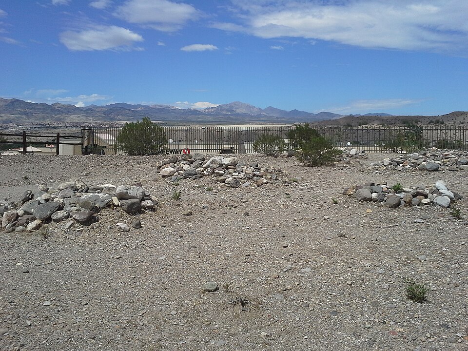
Photograph of Hardyville Cemetery
Photograph by grekit, CC BY-SA 3.0. Via Wikimedia Commons.

Hardyville Cemetery

Listed on the National Register of Historic Places in 2001.

From the record

“The Hardyville Cemetery, also known as the Hardyville Pioneer Cemetery, at 1776 Arizona State Route 95 in Bullhead City, Arizona, is a historic 2.5-acre (1.0 ha) cemetery that is listed on the National Register of Historic Places.”

Wikipedia article Hardyville Cemetery, CC BY-SA 4.0.

One of 64 National Register listings published here for Mohave County · listed in 2001 · category: Site.

Sources: the Wikipedia article · the case file at the National Archives · the National Register database, National Park Service

The listing

  • What is counted as historic. The nomination lists 1 site as contributing to the listing.
  • Address. 1776 AZ 95, Bullhead City, 86442
  • When was it listed? August 2001
  • Category. site
  • Census division. Bullhead City
  • National Register reference number. 01000905 - the number the National Park Service assigned this property when it was listed, and the key its nomination file is catalogued under at the National Archives.

Fires near this property

268 since 1992

Regional context, not property-specific evidence. The federal wildfire occurrence database lists 268 fires within 5 miles of Hardyville Cemetery between 1992 and 2020, burning about 454 acres in total. 4 started naturally. 4 were recorded as arson. Distance is straight-line from the map coordinates, so a fire counted here may appear on a neighbouring settlement's page as well.

Reported cause Fires
Missing data/not specified/undetermined233
Equipment and vehicle use7
Smoking6
Natural4
Railroad operations and maintenance4
Arson/incendiarism4
Power generation/transmission/distribution3
Debris and open burning3
Recreation and ceremony2
Fireworks1
Misuse of fire by a minor1

The most recent of them, most recent first, with the day each was reported and the service that recorded it.

DateCause SizeReported by Name on the report
8 September 2020Missing data/not specified/undeterminedunder an acreArizona Department of Forestry and Fire Management - State Officenot named
6 September 2020Missing data/not specified/undeterminedunder an acreArizona Department of Forestry and Fire Management - State Officenot named
4 September 2020Missing data/not specified/undeterminedunder an acreArizona Department of Forestry and Fire Management - State Officenot named
30 September 2019Missing data/not specified/undeterminedunder an acreBullhead City Fire DepartmentNOT NAMED
3 September 2018Missing data/not specified/undeterminedunder an acreBullhead City Fire Department1807202
29 September 2020Missing data/not specified/undeterminedunder an acreArizona Department of Forestry and Fire Management - State Officenot named
26 September 2020Missing data/not specified/undetermined47 acresClark County Fire DepartmentCCFD 12 - AVI 2
24 September 2020Missing data/not specified/undeterminedunder an acreArizona Department of Forestry and Fire Management - State Officenot named

Every fire recorded in Mohave County

Mines and quarries near this property

10 of 12 shown

Regional context, not property-specific evidence. The federal mineral resources record lists 12 workings within 5 miles of Hardyville Cemetery: 6 past producers, 4 producers, 1 plant, 1 unknown. 5 still produce. What was taken out: Sand and Gravel, Construction, Gold, Stone, Silver. Distance is straight-line from the map coordinates, so a quarry counted here may appear on a neighbouring settlement's page as well.

Where SiteCommodity StatusRecorded
Homestake GroupGold, SilverPast Producer
Unnamed QuarryStonePast Producer
Treasure Trove MineGoldPlant
Asphalt Material Pit and PlantSand and Gravel, ConstructionPast Producer
Asphalt Materials Pit and PlantSand and Gravel, ConstructionPast Producer
Gravel PitSand and Gravel, ConstructionPast Producer
Jack Ward PitSand and Gravel, ConstructionPast Producer
Laughlin PitSand and Gravel, ConstructionProducer
Laughlin Ready Mix PitSand and Gravel, ConstructionProducer
Number 3 Rio LomesSand and Gravel, ConstructionProducer

Every working recorded in Mohave County

Storms near this property

40 since 1993

Regional context, not property-specific evidence. The National Weather Service names Bullhead City, the town this property stands in, in 40 storm reports between 1993 and 2024: 25 thunderstorm wind, 7 flash flood, 4 lightning, 1 hail. No death or injury is recorded in these reports. Each account below is quoted exactly as the forecast office filed it, from the NOAA Storm Events Database, and each date opens the federal record of that event.

WhenEvent Place namedHarm What the report says
September 1997Thunderstorm WindBullhead City$750,000A powerful thunderstorm unleashed a destructive wind that wreaked havoc on a small section of Bullhead City, AZ. The fierce wind snapped 24 power poles and damaged approximately 80 houses and mobile homes. Roofs were blown off or damaged, a garage was blown away and numerous awnings were ripped off and hurled through the air. 22 of the homes were condemned.
July 1999Thunderstorm WindBullhead City$500,000no account filed
July 2016Thunderstorm WindBullhead City$125,000Nine power poles were blown down in Bullhead City and Mohave Valley. Several trees were blown down in Mohave Valley, and there was minor damage to structures.
April 2012Heavy RainBullhead City$100,000Heavy rain caused the roof of a building in Bullhead City to collapse. The interior was damaged as well.
July 2012LightningBullhead City$50,000Lightning knocked out power to 4000 customers in the Bullhead City area.
August 1993Thunderstorm WindBullhead City$50,000High winds, small hail and heavy rains tore down signs, uprooted trees, and caused considerable damage to homes. At one residence, a board was embedded in the garage wall.
September 1999Thunderstorm WindBullhead City$25,000Strong thunderstorm winds swept through an area extending north from Mohave Valley to Temple Bar Marina on Lake Mead. Power was knocked out to 300 homes and business in Mohave Valley and Bullhead City due to downed power poles and several tree branches being blown into power lines. Estimated wind gusts up to 65 miles an hour occurred along Lake Mohave and some awnings were damaged at Temple Bar.
August 2013LightningBullhead City$20,000Lightning knocked out power to 186 customers in Bullhead City.
August 2010Thunderstorm WindBullhead City$20,000Thunderstorm winds blew down power lines and blew awnings off several mobile homes.
August 1997Thunderstorm WindBullhead City$15,000The Bullhead City Fire Department reported damaging winds resulting in broken tree branches, downed power lines, awnings torn off mobile homes and a blown down shed.
June 2016Thunderstorm WindBullhead City$10,000Winds gusted to 62 mph at KIFP, and trees were blown down and travel trailers flipped farther south.
November 2013LightningBullhead City$10,000Lightning knocked out power to 800 customers.
July 2012LightningBullhead City$10,000Lightning knocked out power to over 600 customers in Bullhead City.
July 2008Thunderstorm WindBullhead City$10,000Thunderstorm winds blew signs off several businesses, blew shingles and an awning off a house, and blew one person over (no injury) in Bullhead City.
March 2023Flash FloodBullhead City$5,000Highway 95 was closed near 7th Street, and multiple swift water rescues were needed.
July 2015Thunderstorm WindBullhead City$5,000Several four foot tall trees were blown down along Bullhead Parkway.
August 1997Thunderstorm WindBullhead City$5,000The Mohave County Sheriff's Office reported sustained winds at an estimated 60 mph, with gusts up to 75 mph, over an area extending from the Mohave Valley to Lake Havasu City, AZ. Visibilities were reduced to zero and some homes in Lake Havasu City sustained minor damage to roofs and windows.
July 2004Thunderstorm WindBullhead City$2,000Five forty foot telephone poles were blown down by strong thunderstorm winds.
July 1998Thunderstorm WindBullhead City$2,000no account filed
April 2020Flash FloodBullhead City$1,000AZ Highway 95 was closed near 3rd Street due to flooding.
July 2014Flash FloodBullhead City$1,000Mud washed onto Bullhead Parkway.
February 2010Flash FloodBullhead City-Boulders were washed onto AZ Highway 95 between Silver Creek Rd. and Riverview Dr. Most side streets were also covered with water.
June 2006Thunderstorm WindBullhead City-Also blowing dust and sand.
July 2006Thunderstorm WindBullhead City-Also near zero visibility in blowing dust.
July 2006Thunderstorm WindBullhead City-On Arizona Highway 68.
August 2005Flash FloodBullhead City-Several homes knocked off their foundations in Fort Mohave and Mohave Valley.
August 2005Flash FloodBullhead City-2.5 feet of water over roads. One driver rescued.
July 2005Thunderstorm WindBullhead City-Light poles blown down in Mohave Valley.
April 2001Funnel CloudBullhead City-Funnel cloud was sighted by a patrol officer behind the 911 operations center.
April 2001Tornado (F1)Bullhead City-A small tornado was spotted over open terrain near the three state junction over the Colorado River. This tornado began in San Bernardino County, CA at 11:35 am and moved across a small part of Clark County, NV before moving into Mohave County, AZ at 11:39 am. The tornado then dissipated at 11:50 am.
October 2000Flash FloodBullhead City-Heavy rain and thunderstorms moved through Bullhead City, AZ producing minor flooding that left rocks and debris across "Bullhead Highway".
July 2024Thunderstorm WindBullhead City-no account filed
July 2022Thunderstorm WindBullhead City-no account filed
July 2015Thunderstorm WindBullhead City-no account filed
August 2010Thunderstorm WindBullhead City-no account filed
July 2009Thunderstorm WindBullhead City-no account filed
September 2006Thunderstorm WindBullhead City-no account filed
August 2005Thunderstorm WindBullhead City-no account filed
September 1996HailBullhead City-no account filed

Every storm recorded in Mohave County

Map coverage status

No historic map-sheet match is published for this property yet. That does not mean no map exists. This record needs a coordinate-quality review before it can be joined to a sheet boundary. Browse the county's mapped places while that work is pending.

Sources for this property

National Archives recordThe nomination case file for reference 01000905 in Record Group 79.
Wikipedia articleCommunity-written account of this property, licensed CC BY-SA.
Mohave CountyAll 64 listed properties in this county.

Provenance

  • Listing record. National Park Service National Register of Historic Places, listed-properties dataset, current to 2026-05-22.
  • Map join. Address geocoded through the United States Census geocoder, then tested against the published boundary of every sheet in the USGS Historical Topographic Map Collection.
  • How this page is made. Listing fields come from federal records; map-sheet coverage is a labelled coordinate-to-boundary calculation, not a source-field claim.
  • Wildfire. Short, Karen C. 2022. Spatial wildfire occurrence data for the United States, 1992-2020 [FPA_FOD_20221014]. 6th Edition. Fort Collins, CO: Forest Service Research Data Archive. https://doi.org/10.2737/RDS-2013-0009.6 Collected with United States Government funding and usable without additional permissions or fees.
  • Mines and quarries. USGS Mineral Resources Data System (MRDS) https://mrdata.usgs.gov/mrds/ A work of the United States government, no copyright under 17 U.S.C. 105.
  • Storms. NOAA National Centers for Environmental Information, Storm Events Database https://www.ncei.noaa.gov/stormevents/ A work of the United States government, no copyright under 17 U.S.C. 105. Narratives are quoted verbatim from the National Weather Service report and are not edited or summarised.