 Block
From the record
One of 204 National Register listings published here for Pima County · listed in 2015 · category: Building.
Sources: the National Register database, National Park Service
Listed on the National Register of Historic Places in 2015.
One of 204 National Register listings published here for Pima County · listed in 2015 · category: Building.
Sources: the National Register database, National Park Service
Regional context, not property-specific evidence. The federal wildfire occurrence database lists 225 fires within 5 miles of Shrine of Santa Rita in the Desert between 1992 and 2020, burning about 282 acres in total. 7 started naturally. 3 were recorded as arson. Distance is straight-line from the map coordinates, so a fire counted here may appear on a neighbouring settlement's page as well.
| Reported cause | Fires |
|---|---|
| Missing data/not specified/undetermined | 186 |
| Equipment and vehicle use | 12 |
| Natural | 7 |
| Smoking | 5 |
| Recreation and ceremony | 4 |
| Railroad operations and maintenance | 4 |
| Debris and open burning | 3 |
| Arson/incendiarism | 3 |
| Misuse of fire by a minor | 1 |
The most recent of them, most recent first, with the day each was reported and the service that recorded it.
| Date | Cause | Size | Reported by | Name on the report |
|---|---|---|---|---|
| 8 September 2015 | Missing data/not specified/undetermined | under an acre | Arizona Department of Forestry and Fire Management - State Office | WENTWORTH |
| 5 September 2019 | Missing data/not specified/undetermined | under an acre | Rincon Valley Fire District | NOT NAMED |
| 22 September 2020 | Missing data/not specified/undetermined | under an acre | Arizona Department of Forestry and Fire Management - State Office | not named |
| 13 September 2017 | Missing data/not specified/undetermined | under an acre | Rincon Valley Fire District | not named |
| 11 September 2020 | Missing data/not specified/undetermined | under an acre | Arizona Department of Forestry and Fire Management - State Office | not named |
| 11 September 2018 | Missing data/not specified/undetermined | under an acre | Rincon Valley Fire District | 1501 |
| 10 September 2017 | Missing data/not specified/undetermined | under an acre | Rincon Valley Fire District | not named |
| 7 August 2017 | Missing data/not specified/undetermined | under an acre | Tucson Fire Department | not named |
Regional context, not property-specific evidence. The federal mineral resources record lists 12 workings within 5 miles of Shrine of Santa Rita in the Desert: 8 occurrences, 3 past producers, 1 unknown. None of them still produces. What was taken out: Uranium, Gypsum-Anhydrite, Copper, Copper, Gold, Silver. Distance is straight-line from the map coordinates, so a quarry counted here may appear on a neighbouring settlement's page as well.
| Where | Site | Commodity | Status | Recorded |
|---|---|---|---|---|
| Aqua Verde Mine | Stone, Crushed/Broken | Occurrence | ||
| Chief Group | Lead, Gold, Silver | Past Producer | ||
| Heavy Boy Prospect | Barium-Barite | Occurrence | Barite | |
| Unknown | Sand and Gravel, Construction | Occurrence | ||
| Virginia Belle Mine | Copper, Gold, Silver | Past Producer | ||
| Weslick | Silver, Copper | Past Producer | ||
| Red Hills Claims | Uranium | Occurrence | ||
| Red Hils Claims | Uranium | Occurrence | Unknown | |
| Rincon Mtn Group | Copper | Unknown | ||
| Unknown | Copper | Occurrence |
Regional context, not property-specific evidence. The National Weather Service names Vail, the town this property stands in, in 42 storm reports between 1996 and 2025: 18 thunderstorm wind, 13 flash flood, 7 hail, 1 tornado. No death or injury is recorded in these reports. Each account below is quoted exactly as the forecast office filed it, from the NOAA Storm Events Database, and each date opens the federal record of that event.
| When | Event | Place named | Harm | What the report says |
|---|---|---|---|---|
| July 2011 | Thunderstorm Wind | Vail | $750,000 | A strong fast moving storm caused widespread damage across the Tucson area. Power lines and a large tree were downed near Oracle Road and Hardy Road. More power lines were downed near Park Avenue and Broadway Boulevard in midtown Tucson. Several additional trees were downed including two large trees in Vail, a 60-foot tree near Tanque Verde and Wrightstown Road, and a 100-foot tall tree onto a vehicle in northern Tucson. Two additional trees were also downed on vehicles. One fell on a car in the Fairview Manor near Miracle Mile and Fairview and another tree fell on a car near Broadway and Craycroft. The same tree also brought a light pole down on a truck. Strong winds also ripped a roof off a mobile home in southwest Tucson and destroyed several outbuildings throughout the city. In addition, winds peeled the roof off the Literacy of Life office in Mid-town. Over 20,000 Tucson Electric Power customers were without power after the storms passed. |
| July 2011 | Thunderstorm Wind | Vail | $750,000 | Strong thunderstorm winds resulted in significant damage around southern portions of the Tucson Metro area. Davis-Monthan Air Force Base recorded a wind gust of 67 knots (77mph) while the Tucson International Airport recorded a gust of 61 knots (70 mph). The most significant damage was sustained by businesses in South Tucson. Near Ajo Way and County Club, two industrial buildings sustained partial roof collapses with one business losing the entire roof. A Safeway Grocery Store in the Rita Ranch Village suffered a partial roof collapse. Several power poles and power lines were also downed with several blown transformers. Around 27,000 residents were without power at the peak of the storm. Several trees were downed, with trees falling on homes, cars, and into traffic creating road closures. The most significant tree damage was at the McGuire Hills Apartment Complex. Several trees were downed blocking access to many of the apartments. |
| July 2021 | Flood | Vail | $200,000 | Widespread heavy rain across eastern Pima County resulted in widespread flooding of roadways and high flows along Pantano Wash and Rillito River. Significant damage to the Loop hiking and biking trail system occurred. |
| August 2000 | Thunderstorm Wind | Vail | $100,000 | Several mibile home trailers blown off their foundations. Several totally destroyed. |
| July 2010 | Thunderstorm Wind | Vail | $55,000 | Severe thunderstorm winds caused damage across southern portions of Tucson. A trained spotter reported several trees downed near Rita Ranch at 5 PM MST. Power lines were reported down by the winds at two different locations near the Tucson International Airport. Thunderstorm winds ripped the roof off a mobile home near the intersection of Interstate 19 and Valencia Road. In addition, several other trees and power lines were downed by the thunderstorm winds across southwest portions of Tucson. One of these trees was downed on a residence. |
| September 2025 | Flash Flood | Vail | $30,000 | Online article described a swift water rescue for 5 individuals on Old Spanish Trail Rd. An estimated 12 to 18 inches of running water in wash that went over the roadway. No one was injured. |
| August 2015 | Thunderstorm Wind | Vail | $20,000 | Thunderstorm winds damaged a gas station awning near Houghton and Valencia. Several large trees were damaged with at least 4 power poles snapped along the west side of Houghton between Valencia and E Rita Road, closing the road for several hours and leaving nearly 3500 customers without electricity. |
| July 2014 | Thunderstorm Wind | Vail | $10,000 | Thunderstorm winds snapped six power poles and downed trees along Old Spanish Trail from Irvington to Golf Links Roads. Over 1600 homes were left without power southeast of Houghton Escalante Roads. |
| July 2003 | Thunderstorm Wind | Vail | $6,000 | no account filed |
| July 2024 | Thunderstorm Wind | Vail | $5,000 | Several trees down in Rita Ranch due to strong thunderstorm winds. |
| September 2024 | Thunderstorm Wind | Vail | $5,000 | Multiple trees uprooted in neighborhood. Time estimated based on radar. |
| July 2012 | Flash Flood | Vail | $5,000 | Flash flooding closed streets in far southeast Tucson and in the Vail area including Old Spanish Trail, Collossal Cave Road, Escalante at Atterbury Wash and Harrison at the Pantano Wash. Several cars were stranded in flood waters on Houghton Road between Bilby and Valencia Roads. |
| August 2001 | Flash Flood | Vail | $4,000 | no account filed |
| June 2015 | Thunderstorm Wind | Vail | $3,000 | Thunderstorms winds uprooted several trees in the Rita Ranch. |
| July 2021 | Thunderstorm Wind | Vail | $500 | Thunderstorm winds downed a tree near Interstate 10 and Houghton. |
| September 2015 | Thunderstorm Wind | Vail | $500 | Thunderstorm winds uprooted trees and snapped branches in the Rancho Del Lago neighborhood in Vail. |
| September 2025 | Hail | Vail | - | Social media post estimating 1 inch diameter hail. Time estimated based on radar. |
| August 2024 | Thunderstorm Wind | Vail | - | A weather station measured a wind gust of 58 mph. |
| July 2024 | Thunderstorm Wind | Vail | - | A private weather station recorded a wind gust of 60 mph. |
| July 2024 | Thunderstorm Wind | Vail | - | A personal weather station reported a gust of 66 mph. |
| July 2022 | Flash Flood | Vail | - | Heavy rain of 1-2 in 90 minutes caused flash flooding of roadways from southeast to north central Tucson. Road closures included Escalante at Atterbury Wash, Harrison and Pantano Wash, Old Spanish Trail and Freeman Road, Bears Path Rd. south of Tanque Verde Road and Rudasill at Pima Wash. |
| July 2021 | Flash Flood | Vail | - | Heavy rain of 2.5 in less than 90 minutes occurred near the headwaters of Rincon Creek. Flash flooding occurred downstream in the Rincon Ranch Estates area. Camino Loma Alta became flooded and impassible. |
| July 2021 | Flash Flood | Vail | - | Three hour rainfall of 2.5 fell at the headwaters of Rincon Creek, causing rapid rises in stream flow and flash flooding of Old Spanish Trail. |
| July 2021 | Flash Flood | Vail | - | One to two inches of rain on saturated ground cause numerous flooded and closed roads in the Vail area from just east of Rita Ranch to Old Spanish Trail and south to near Interstate 10. One vehicle was stuck in floodwaters near Old Spanish Trail and Drexel Rd. |
| April 2018 | Dust Devil | Vail | - | A small dust devil lifted an unsecured tent covering a petting zoo during the Pima County Fair. The tent contacted electrical wires which resulted in a power outage at the fairgrounds for about an hour. |
| July 2017 | Flash Flood | Vail | - | Heavy rain on the Rincon Mountains caused high flows on Tanque Verde Creek and Rincon Creek. Redington Pass Road was flooded and Rincon Creek at Rincon Gauge recorded a crest of 9.32 feet. This is the fourth highest on record for this site. |
| July 2016 | Hail | Vail | - | Nickel size hail fell at Garigan's Gulch and Rincon Mesa Drive in Vail. |
| August 2015 | Tornado (EF0) | Vail | - | A faint and likely weak landspout tornado spun up from a dust devil before attaching to the cloud base near Interstate 10 and Houghton. |
| August 2013 | Thunderstorm Wind | Vail | - | Thunderstorms produced gusty winds at Saguaro National Park East with a 63 mph gust measured near Old Spanish Trail and Freeman Road. |
| July 2008 | Flash Flood | Vail | - | Four and a half inches of rainfall occurred at Manning Camp in the Rincon Mountains in less than 2 hours causing excessive runoff into area washes. |
| August 2008 | Thunderstorm Wind | Vail | - | A trained spotter estimated wind gusts to 65 mph. |
| July 2008 | Flash Flood | Vail | - | The Pantano Wash at Vail crested at 12.6 feet or 1.6 feet above bankful at 9:00 PM. |
| August 2007 | Flash Flood | Vail | - | A swift water rescue occurred at Wilmot and Interstate 10 in Southeast Tucson due to flash flooding. |
| August 2007 | Hail | Vail | - | Three quarter inch hail was reported near Vail from a trained spotter. |
| July 2005 | Hail | Vail | - | Three quarter inch hail was reported by a trained spotter near the Town of Mescal. |
| July 1998 | Flash Flood | Vail | - | An automata gage near Vail reported a 3 foot rise in water in about 1 hour in the Pantano wash. |
| July 2022 | Hail | Vail | - | no account filed |
| June 2018 | Funnel Cloud | Vail | - | no account filed |
| September 1999 | Hail | Vail | - | no account filed |
| August 1998 | Thunderstorm Wind | Vail | - | no account filed |
| August 1996 | Hail | Vail | - | no account filed |
| August 1996 | Flash Flood | Vail | - | no account filed |
No historic map-sheet match is published for this property yet. That does not mean no map exists. This record needs a coordinate-quality review before it can be joined to a sheet boundary. Browse the county's mapped places while that work is pending.
Other National Register properties close enough to walk or drive between, ordered by distance from this one. Both positions come from the same geocoding pass that matched these properties to their map sheets.
| Photograph | Property | Distance | Listed |
|---|---|---|---|
| Vail Post Office, Old | 0.1 miles | 2011 | |
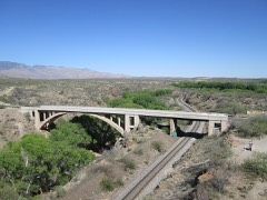 | Cienega Bridge | 4.4 miles | 1988 |
| Colossal Cave Preservation Park Historic District | 4.6 miles | 1992 |
| National Archives record | The nomination case file for reference 14001231 in Record Group 79. |
| Pima County | All 204 listed properties in this county. |