 Block
From the record
One of 127 National Register listings published here for Yavapai County · listed in 1989 · category: Building.
Sources: the case file at the National Archives · the National Register database, National Park Service
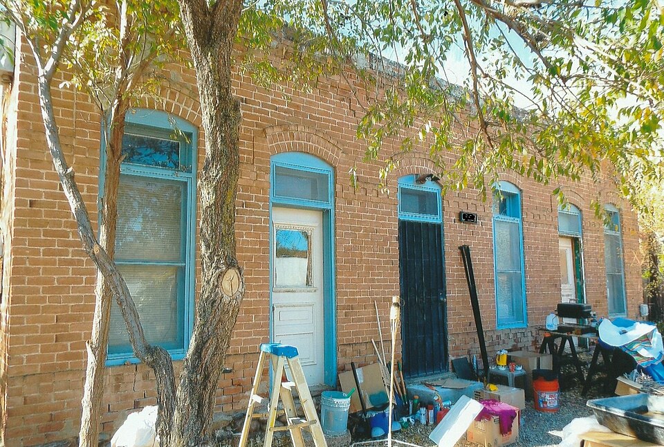
Listed on the National Register of Historic Places in 1989.
One of 127 National Register listings published here for Yavapai County · listed in 1989 · category: Building.
Sources: the case file at the National Archives · the National Register database, National Park Service
Regional context, not property-specific evidence. The federal wildfire occurrence database lists 81 fires within 5 miles of Mayer Apartments between 1993 and 2020, burning about 385 acres in total. 9 started naturally. 1 was recorded as arson. Distance is straight-line from the map coordinates, so a fire counted here may appear on a neighbouring settlement's page as well.
| Reported cause | Fires |
|---|---|
| Missing data/not specified/undetermined | 56 |
| Equipment and vehicle use | 9 |
| Natural | 9 |
| Smoking | 3 |
| Recreation and ceremony | 2 |
| Debris and open burning | 1 |
| Arson/incendiarism | 1 |
The most recent of them, most recent first, with the day each was reported and the service that recorded it.
| Date | Cause | Size | Reported by | Name on the report |
|---|---|---|---|---|
| 4 September 2016 | Equipment and vehicle use | under an acre | Prescott National Forest | MOTOR |
| 29 September 2009 | Equipment and vehicle use | 1.0 acres | Arizona Department of Forestry and Fire Management - State Office | 4TH STREET |
| 17 September 1993 | Missing data/not specified/undetermined | under an acre | Arizona Department of Forestry and Fire Management - State Office | not named |
| 8 August 2003 | Smoking | under an acre | Phoenix District Office | POLAND |
| 6 August 2020 | Missing data/not specified/undetermined | under an acre | Arizona Department of Forestry and Fire Management - State Office | not named |
| 31 August 2004 | Natural | under an acre | Prescott National Forest | BELL |
| 25 August 2020 | Missing data/not specified/undetermined | under an acre | Arizona Department of Forestry and Fire Management - State Office | not named |
| 24 August 2019 | Missing data/not specified/undetermined | under an acre | Mayer Fire District | NOT NAMED |
Regional context, not property-specific evidence. The federal mineral resources record lists 78 workings within 5 miles of Mayer Apartments: 23 past producers, 20 producers, 16 prospects, 10 occurrences. 20 still produce. What was taken out: Copper, Gold, Gold, Silver, Silver. Distance is straight-line from the map coordinates, so a quarry counted here may appear on a neighbouring settlement's page as well.
| Where | Site | Commodity | Status | Recorded |
|---|---|---|---|---|
| Alteration Group | Copper, Lead, Zinc | Prospect | ||
| Blue Bell Mine | Copper, Silver, Gold, Lead, Zinc, Arsenic | Past Producer | 1895, 1896, 1959 | |
| Blue Bell Mine and Quarry | Stone, Dimension, Copper, Silver, Gold, Iron, Silica | Past Producer | ||
| Blue Bell Siding | Iron, Manganese, Titanium, Phosphorus-Phosphates, Silica | Occurrence | ||
| Boggs Patented 908 | Copper, Gold, Lead, Silver, Zinc | Past Producer | ||
| Butternut Mine | Gold, Copper, Silver, Zinc, Arsenic | Producer | 1902, 1946 | |
| Butternut Property | Copper, Lead, Silver, Zinc, Gold | Past Producer | ||
| Copper Queen Mine | Copper, Silver, Gold, Zinc, Arsenic | Past Producer | 1901, 1967 | |
| Hackberry | Gold, Copper, Zinc, Silver, Lead | Unknown | ||
| Hull Property | Copper, Lead, Gold, Silver, Zinc | Past Producer |
Regional context, not property-specific evidence. The National Weather Service names Mayer, the town this property stands in, in 40 storm reports between 1995 and 2025: 25 flash flood, 6 hail, 3 thunderstorm wind, 3 heavy rain. No death or injury is recorded in these reports. Each account below is quoted exactly as the forecast office filed it, from the NOAA Storm Events Database, and each date opens the federal record of that event.
| When | Event | Place named | Harm | What the report says |
|---|---|---|---|---|
| July 2017 | Flash Flood | Mayer | $7,000,000 | Thunderstorms produce heavy rain over the Goodwin Fire scar. This lead to flash flooding in Big Big Bug Creek and Grapevine Creek which both flow into the Agua Fria River. This lead to a double crest in the flash flood downstream. The flooding started around 1745 in Mayer and 1845 in Spring Valley. People were evacuated in Mayer. The stream gauge on Agua Fria River near Mayer showed a 5.84 foot rise in 45 minutes (830 to 915 PM MST). ||This is a list of the damage: ||Homes destroyed - 15|Major damage - 25|Minor damage - 17|Affected - 10|Impacted - 53||Total: 120||Most of the homes that were damaged were in Mayer with a few in Spring Valley. |
| July 2025 | Flash Flood | Mayer | - | Public reported, via social media, a video of flash flooding in Big Bug Creek across a low water crossing. |
| September 2025 | Flash Flood | Mayer | - | The county stream gauge at Mayer (54936 - Big Bug Creek @ SR 69) reported a 4.4 ft rise in 30 minutes, peaking at 1:55 pm. |
| July 2024 | Flash Flood | Mayer | - | Yavapai County ALERT stream gage measured a 1.5 ft rise on Big Bug Creek in Mayer. |
| July 2023 | Flash Flood | Mayer | - | The Agua Fria River near Cordes Junction rose 2.2 feet between 1100 PM on July 22 and midnight on July 23. The water remained elevated for about 12 hours. |
| August 2022 | Flash Flood | Mayer | - | Big Bug Creek in Spring Valley rose 1-2 feet. |
| August 2022 | Flash Flood | Mayer | - | A video of a flood in Big Bug Creek was posted on social media. The creek is normally dry. |
| August 2022 | Flash Flood | Mayer | - | The stream gauge on the Big Bug Creek in Mayer showed a rise from 1.9 to 4.9 feet in about 40 minutes starting at noon. The flood water over topped the Spring Lane bridge over Big Bug Creek in Spring Valley at 130 PM. A video on social media showed water flowing over a low water crossing on Thunderbird Trail in Cordes Junction at 155 PM. A river gauge on the Agua Fria River just downstream from the confluence with the Big Bug Creek showed a rise from 3.7 feet to 7.9 feet between 200 PM to 300 PM. |
| July 2022 | Flash Flood | Mayer | - | Flooding was reported in Alberson Wash/Rose Creek, Lynx Creek, and Agua Fria River all the way to Skull Valley. |
| July 2021 | Thunderstorm Wind | Mayer | - | A thunderstorm produced 1/2 inch hail, torrential rainfall, and wind damage. The wind damage included a snapped flag pole, a BBQ grill was pushed off a deck, and multiple tree limbs were broken off trees. |
| September 2019 | Flash Flood | Mayer | - | Big Bug Creek in Mayer rose 2.5 feet between 1230 and 130 PM. |
| September 2019 | Flash Flood | Mayer | - | Jefferson Road near Mayer near Mayer was flooded and impassable around 11 AM due to heavy rain in the area. |
| August 2018 | Flash Flood | Mayer | - | Big Bug Creek at Mayer rose 5 feet between 550 and 610 PM. This flood water continued |down stream into the Agua Fria River. The gauge on the Agua Fria River near Cordes Junction measured a 3.7 foot rise between 8:30 and 9 PM. |
| August 2018 | Flash Flood | Mayer | - | The stream gauge on Big Bug Creek recorded a 2.1 foot rise at 140 PM MST. The Agua Fria gauge showed a 2.7 foot rise (730 CFS increase) at 613 PM. |
| July 2018 | Flash Flood | Mayer | - | Heavy rain fell over the Goodwin Fire scar east of Mayers. This resulted in flash flooding in Mayers and East Central Avenue was closed. |
| July 2018 | Flash Flood | Mayer | - | The river gauge on Big Bug Creek at Mayer showed a 2.1 rise at 620 MST due to heavy rain from a thunderstorm over the Goodwin Fire scar. A second flood wave of the same height came at 1050 PM MST. |
| July 2018 | Flash Flood | Mayer | - | The stream gauge at Big Bug Creek at Mayer reported a 3.1 foot rise at 1040 PM MST. |
| July 2018 | Flash Flood | Mayer | - | The gauge on Agua Fria River near Mayer reported a rapid rise of 6 feet. |
| August 2018 | Flash Flood | Mayer | - | At 554 PM, the stream gauge on Big Bug Creek in Mayer measured a 5 foot rise. At 630 PM, South Spring Lane was closed due to flooding near East Trails End Road. There was a 5 foot rise on Agua Fria River near Cordes Junction at 8:40 PM. |
| August 2018 | Flash Flood | Mayer | - | Big Bug Creek rose 2.1 feet in 70 minutes due to heavy rainfall near and over the Goodwin Fire scar upstream from the town of Mayer. Big Bug Creek flowing through Cordes Lakes rose by 3 feet in 45 minutes (415 PM). |
| October 2018 | Flash Flood | Mayer | - | Two feet of water flowed through Big Bug Creek. Prolonged moderate to heavy rain over the area and the Goodwin Fire scar caused this flood. |
| August 2017 | Flash Flood | Mayer | - | Heavy rain over the Goodwin Fire scar caused a flash flood in Big Bug Creek The river gauge at State Route 69 reported a peak of 5.1 feet...an estimated four foot rise. |
| July 2017 | Flash Flood | Mayer | - | Heavy rain over the Goodwin Fire scar caused Big Bug Creek to flash flood in Meyer. The waster rose 2 to 2.5 feet (50 feet wide) at the Central Avenue Bridge. |
| July 2017 | Flash Flood | Mayer | - | Heavy rain over the Goodwin Fire scar caused flash flooding downstream. The water was reported to be two feet over the Spring Lane Bridge crossing Big Bug Creek. |
| June 2016 | Heavy Rain | Mayer | - | Heavy rain and dime sized (0.70 inch diameter) caused flowing water in area washes/road crossings. |
| July 2016 | Heavy Rain | Mayer | - | An alert rain gauge near Cordes Junction reported 2.28 inches of rain in an hour and 20 minutes. |
| July 2016 | Flash Flood | Mayer | - | The 50s Diner and Bar flooded with 3 foot deep water throughout the building. The Arizona DPS reported that cars were stuck in flooding on I-70 with mud and hail piled on the road surface. The river gauge on Agua Fria River rose 6.5 feet (0 to 2,900 CFS in less than 15 minutes at 730 PM). |
| July 2013 | Hail | Mayer | - | One inch diameter hail fell with 0.38 inches of rain in just 10 minutes. |
| July 2013 | Heavy Rain | Mayer | - | About 1.28 inches of rain fell in just 45 minutes ten miles south of Mayer. |
| October 2010 | Funnel Cloud | Mayer | - | A funnel cloud was reported west of I-17 by a motorist traveling on the interstate. |
| July 2008 | Hail | Mayer | - | The Yavapai County Sheriff's Office reported nickle sized hail in and around Mayer. |
| July 2008 | Thunderstorm Wind | Mayer | - | Strong thunderstorm winds knocked down power lines in Mayer. |
| July 2004 | Flash Flood | Mayer | - | A line of thunderstorms in the Prescott area produced very heavy rainfall that caused rapid rise in water in the Agua Fria River. A river gage near Mayer indicated that the Agua Fria River rose nearly 5 feet due to the heavy rainfall. |
| September 2003 | Hail | Mayer | - | Dime sized (3/4 inch diameter) hail was reported in Mayer. |
| May 2003 | Thunderstorm Wind | Mayer | - | A microburst produced a wind gust of 70 MPH about three miles south of Mayer. |
| September 1999 | Flood | Mayer | - | Thunderstorm rains of two inches in two hours forced Big Bug Creek out of its banks with over one foot of water across nearby roadways. |
| August 1997 | Hail | Mayer | - | One and a half (1.5) inch diameter hail reported in Mayer. |
| May 1997 | Funnel Cloud | Mayer | - | Spotter reported a funnel cloud but the report was unconfirmed and only minor thunderstorms were in the area at the time. |
| September 1995 | Hail | Mayer | - | A poultry barn was destroyed killing 500 turkeys inside. Numerous trees were stripped of leaves and branches. Many birds were killed. Many south-facing windows were broken. A large motel sign was damaged and nearly toppled. A large commercial trash dumpster was moved over 50 yards. A spotter in the area estimated wind gusts to be 75 mph. |
| August 1995 | Hail | Mayer | - | no account filed |
No historic map-sheet match is published for this property yet. That does not mean no map exists. This record needs a coordinate-quality review before it can be joined to a sheet boundary. Browse the county's mapped places while that work is pending.
Other National Register properties close enough to walk or drive between, ordered by distance from this one. Both positions come from the same geocoding pass that matched these properties to their map sheets.
| Photograph | Property | Distance | Listed |
|---|---|---|---|
 | Mayer Business Block | under 500 feet | 1989 |
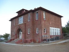 | Mayer Red Brick Schoolhouse | 0.4 miles | 2004 |
| Woolsey Ranchhouse Ruins | 7.9 miles | 1977 |
| National Archives record | The nomination case file for reference 89000860 in Record Group 79. |
| Yavapai County | All 127 listed properties in this county. |