 Block
From the record
16 National Register listings published here, 1 of them a National Historic Landmark.
Sources: the National Register database, National Park Service
45 topographic sheets cover 9 settlements here, and 16 properties are on the National Register of Historic Places.
16 National Register listings published here, 1 of them a National Historic Landmark.
Sources: the National Register database, National Park Service
Every property in this county listed on the National Register of Historic Places, with the year it was listed and the federal nomination document.
| Photograph | Property | Type | Listed | Reference |
|---|---|---|---|---|
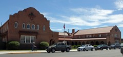 | Alamosa County Courthouse | building | 1995 | 95001149 |
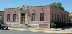 | Alamosa Post Office | building | 2009 | 09000544 |
| Alamosa Spanish Cemetery | site | 2025 | 100012458 | |
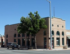 | American National Bank Building | building | 1999 | 99000446 |
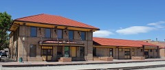 | Denver and Rio Grande Railroad Depot | building | 1993 | 93000034 |
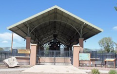 | Denver and Rio Grande Railroad Locomotive No.169 | structure | 2001 | 01000230 |
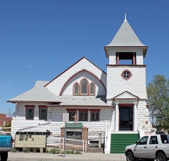 | First Baptist Church | building | 2005 | 05000425 |
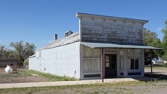 | Howard Store | building | 2006 | 05001597 |
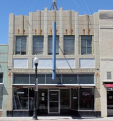 | Husung Hardware | building | 2000 | 00000003 |
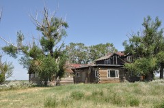 | Medano Ranch Headquarters | district | 2004 | 03001543 |
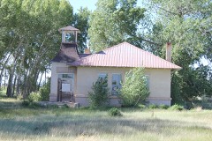 | Mt. Pleasant School | building | 2006 | 06000327 |
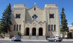 | Sacred Heart Catholic Church | building | 1998 | 98000855 |
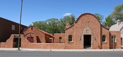 | St. Thomas Episcopal Church | building | 2003 | 03000285 |
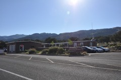 | Superintendent's Residence, Great Sand Dunes National Monument | building | 1989 | 89001761 |
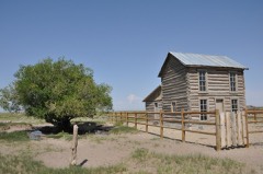 | Trujillo Homestead | district | 2004 | 03001544 |
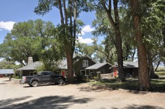 | Zapata Ranch Headquarters | building | 1993 | 93000199 |
Every wildfire the federal occurrence database records inside this county: 310 of them, burning about 4,556 acres. 30 started naturally and 18 were recorded as arson. Each settlement page carries the fires within five miles of it.
| Reported cause | Fires |
|---|---|
| Missing data/not specified/undetermined | 131 |
| Recreation and ceremony | 108 |
| Natural | 30 |
| Arson/incendiarism | 18 |
| Debris and open burning | 8 |
| Smoking | 5 |
| Misuse of fire by a minor | 5 |
| Equipment and vehicle use | 4 |
| Power generation/transmission/distribution | 1 |
The five largest, by the area the report gives. None of them was recorded as arson.
| Date | Cause | Size | Reported by | Name on the report |
|---|---|---|---|---|
| 18 April 2000 | Debris and open burning | 3,124 acres | Great Sand Dunes National Park and Preserve | SAND |
| 6 June 2007 | Power generation/transmission/distribution | 307 acres | Great Sand Dunes National Park and Preserve | MEDANO RANCH |
| 31 March 2011 | Missing data/not specified/undetermined | 300 acres | Colorado State Forest Service-State Headquarters | ALAMOSA |
| 4 August 2008 | Natural | 167 acres | Great Sand Dunes National Park and Preserve | DENTON SPRINGS |
| 24 September 2012 | Natural | 150 acres | Alamosa National Wildlife Refuge | BLUFF |
| 20 April 2017 | Natural | 58 acres | Great Sand Dunes National Park and Preserve | BALD DUNES |
| 13 April 2011 | Missing data/not specified/undetermined | 42 acres | Colorado State Forest Service-State Headquarters | ALAMOSA |
| 26 April 2020 | Debris and open burning | 40 acres | Alamosa Fire Department | N/A |
Every settlement page carries the fires within five miles of it - see the settlement index below.
The NOAA Storm Events Database holds 51 reports for this county, causing no deaths, 1 injury and about $563,840 in recorded property damage. Each settlement page carries the reports that name it.
| Kind of event | Reports |
|---|---|
| Tornado | 17 |
| Thunderstorm Wind | 15 |
| Hail | 14 |
| Lightning | 4 |
| Wildfire | 1 |
The most serious of them, by death, then injury, then recorded damage. The accounts are quoted exactly as the forecast office filed them.
| When | Event | Place named | Harm | What the report says |
|---|---|---|---|---|
| August 1996 | Lightning | Alamosa | 1 hurt | no account filed |
| August 1993 | Hail | Alamosa | $500,000 | Marble-size hail caused an estimated $75,000 damage to nine aircraft at the Alamosa Airport. In addition, the hail damaged vehicles in the airport parking lot, as well as destroying barley fields southwest of Alamosa. |
| September 1997 | Lightning | Alamosa | $40,000 | Lightning struck a mobile home, setting it on fire. It was totally destroyed. |
| March 1995 | Tornado (F1) | Alamosa | $11,000 | A tornado briefly touched down on a farm two miles south of Alamosa in Alamosa County. A large tractor shed had been detached from its concrete foundation. Windshilds of vehicles and fences had been damaged as well. The land owners who witnessed the tornado estimated it to be about 20 feet wide and on the ground for about a 0.1 miles. |
| August 2008 | Tornado (EF1) | Mosca | $8,000 | A brief tornado destroyed a mobile home in a rural area. |
| July 1955 | Tornado (F2) | not stated | $2,500 | no account filed |
| July 2007 | Lightning | Hooper | $2,000 | no account filed |
| June 1956 | Tornado (F1) | not stated | $250 | no account filed |
| June 1983 | Tornado (F1) | not stated | $30 | no account filed |
| June 1982 | Tornado (F1) | not stated | $30 | no account filed |
| July 1958 | Tornado (F0) | not stated | $30 | no account filed |
| September 2025 | Thunderstorm Wind | Alamosa | - | Convective wind gust of 66 mph was measured at KALS observation station. |
| May 2022 | Thunderstorm Wind | Alamosa | - | Alamosa airport. |
| September 2022 | Thunderstorm Wind | Alamosa | - | Alamosa airport. |
| May 2014 | Tornado (EF0) | Mosca | - | A short-lived tornado occurred south of the Great Sand Dunes National Park. |
| May 2013 | Tornado (EF0) | Mosca | - | A landspout occurred over a field. |
| June 2006 | Tornado (F0) | Alamosa | - | Tornado caused no known damage over open country. This tornado moved from Alamosa County to Costilla County. |
| July 2006 | Tornado (F0) | Alamosa | - | A weak, short-lived tornado caused no known damage. |
| July 2004 | Tornado (F0) | Alamosa | - | A brief lived tornado caused no known damage. |
| August 2003 | Tornado (F0) | Alamosa | - | A NWS employee observed two non-mesocyclone tornados (landspouts) under a towering cumulus cloud...which caused no known damage. |
| August 1997 | Tornado (F0) | Mosca | - | A series of funnel clouds with a weak thundershower moved across northern Alamosa county near Mosca. The funnel clouds touched down briefly at least twice, causing no known damage. |
| June 1995 | Tornado (F0) | Alamosa | - | A very brief tornado touched down on open land. |
| May 2022 | Thunderstorm Wind | Alamosa | - | no account filed |
| August 2018 | Thunderstorm Wind | Alamosa | - | no account filed |
| September 2013 | Hail | Hooper | - | no account filed |
| June 2010 | Hail | Hooper | - | no account filed |
| August 2008 | Hail | Mosca | - | no account filed |
| August 2008 | Hail | Mosca | - | no account filed |
| October 2007 | Thunderstorm Wind | Mosca | - | no account filed |
| July 2006 | Thunderstorm Wind | Alamosa | - | no account filed |
| August 2003 | Lightning | Alamosa | - | no account filed |
| April 2000 | Wildfire | Alamosa | - | no account filed |
| June 2000 | Hail | Alamosa | - | no account filed |
| September 2000 | Thunderstorm Wind | Alamosa Arpt | - | no account filed |
| May 1998 | Tornado (F0) | Alamosa | - | no account filed |
| July 1998 | Hail | Alamosa | - | no account filed |
| October 1998 | Hail | Hooper | - | no account filed |
| July 1995 | Hail | Alamosa | - | no account filed |
| July 1995 | Hail | Colorado Springs | - | no account filed |
| July 1995 | Hail | Alamosa | - | no account filed |
| September 1986 | Hail | not stated | - | no account filed |
| May 1984 | Thunderstorm Wind | not stated | - | no account filed |
| June 1975 | Thunderstorm Wind | not stated | - | no account filed |
| March 1974 | Tornado (F0) | not stated | - | no account filed |
| June 1974 | Thunderstorm Wind | not stated | - | no account filed |
| July 1972 | Thunderstorm Wind | not stated | - | no account filed |
| September 1972 | Thunderstorm Wind | not stated | - | no account filed |
| August 1970 | Thunderstorm Wind | not stated | - | no account filed |
| June 1969 | Hail | not stated | - | no account filed |
| May 1962 | Thunderstorm Wind | not stated | - | no account filed |
| June 1961 | Hail | not stated | - | no account filed |
The Survey's mineral resources record lists 47 workings inside this county. 3 still produce and 44 are closed or unrecorded. Each settlement page carries the workings within five miles of it.
| Commodity | Workings |
|---|---|
| Sand and Gravel, Construction | 38 |
| Copper | 4 |
| Molybdenum | 2 |
| Gold, Silver | 2 |
| Sodium | 2 |
| Gold | 2 |
| Silver, Gold | 2 |
| Gold, Copper | 1 |
| Silver | 1 |
| Lead, Tellurium, Bismuth, Silver | 1 |
The least common of them first, because a county's hundredth gravel pit says nothing its first ten did not.
| Where | Site | Commodity | Status | Recorded |
|---|---|---|---|---|
| Blanca Mine | Gold, Lead, Tellurium, Bismuth, Silver | Past Producer | Vein | |
| Swab Mine | Gold, Copper, Silver, Molybdenum | Occurrence | Vein | |
| San Luis Lake | Sodium | Producer | ||
| Unknown | Sodium | Producer | Trona | |
| Unknown | Copper, Gold | Prospect | hydrothermal vein | |
| Unknown | Copper, Gold, Silver | Prospect | hydrothermal vein | |
| Unknown | Copper, Silver, Gold | Prospect | hydrothermal vein | |
| Unnamed Prospect | Gold, Silver | Occurrence | Vein | |
| West Blanca District | Copper, Silver, Gold, Molybdenum | Past Producer | hydrothermal veins | |
| Alamosa Pit #2 | Sand and Gravel, Construction | Producer | ||
| Barrow Pit | Sand and Gravel, Construction | Past Producer | ||
| Gravel Pit | Sand and Gravel, Construction | Past Producer | ||
| Gravel Pit | Sand and Gravel, Construction | Unknown | ||
| Gravel Pit | Sand and Gravel, Construction | Past Producer | ||
| Gravel Pit | Sand and Gravel, Construction | Unknown | ||
| Gravel Pit | Sand and Gravel, Construction | Past Producer | ||
| Gravel Pit | Sand and Gravel, Construction | Past Producer | ||
| Gravel Pit | Sand and Gravel, Construction | Unknown | ||
| Gravel Pit | Sand and Gravel, Construction | Past Producer | ||
| Gravel Pit | Sand and Gravel, Construction | Past Producer | ||
| Gravel Pit | Sand and Gravel, Construction | Past Producer | ||
| Gravel Pit | Sand and Gravel, Construction | Past Producer | ||
| Gravel Pit | Sand and Gravel, Construction | Past Producer | ||
| Gravel Pit | Sand and Gravel, Construction | Past Producer | ||
| Gravel Pit | Sand and Gravel, Construction | Past Producer | ||
| Gravel Pit | Sand and Gravel, Construction | Past Producer | ||
| Gravel Pit | Sand and Gravel, Construction | Unknown | ||
| Gravel Pit | Sand and Gravel, Construction | Past Producer | ||
| Gravel Pit | Sand and Gravel, Construction | Past Producer | ||
| Gravel Pit | Sand and Gravel, Construction | Past Producer | ||
| Gravel Pit | Sand and Gravel, Construction | Past Producer | ||
| Gravel Pit | Sand and Gravel, Construction | Past Producer | ||
| Gravel Pit | Sand and Gravel, Construction | Past Producer | ||
| Unknown | Sand and Gravel, Construction | Occurrence | Gravel | |
| Unknown | Sand and Gravel, Construction | Occurrence | Sand and Gravel | |
| Unknown | Sand and Gravel, Construction | Occurrence | Sand and Gravel | |
| Unknown | Sand and Gravel, Construction | Occurrence | Sand and Gravel | |
| Unknown | Sand and Gravel, Construction | Occurrence | Sand and Gravel | |
| Unknown | Sand and Gravel, Construction | Occurrence | Gravel | |
| Unknown | Sand and Gravel, Construction | Occurrence | ||
| Unknown | Sand and Gravel, Construction | Occurrence | Gravel | |
| Unknown | Sand and Gravel, Construction | Occurrence | Sand and Gravel | |
| Unknown | Sand and Gravel, Construction | Occurrence | Sand and Gravel | |
| Unknown | Sand and Gravel, Construction | Occurrence | Sand and Gravel | |
| Unknown | Sand and Gravel, Construction | Occurrence | Sand and Gravel | |
| Unknown | Sand and Gravel, Construction | Occurrence | Sand and Gravel | |
| Unknown | Sand and Gravel, Construction | Occurrence | Sand and Gravel |
Named settlements recorded in the Geographic Names Information System, each with the topographic sheets covering it. Villages, hamlets and abandoned places alike. Each is shown with the nearest named watercourse or landform and the survey quadrangle it falls on.