 Block
From the record
2 National Register listings published here, 1 of them a National Historic Landmark.
Sources: the National Register database, National Park Service
68 topographic sheets cover 18 settlements here, and 2 properties are on the National Register of Historic Places.
2 National Register listings published here, 1 of them a National Historic Landmark.
Sources: the National Register database, National Park Service
Every property in this county listed on the National Register of Historic Places, with the year it was listed and the federal nomination document.
| Photograph | Property | Type | Listed | Reference |
|---|---|---|---|---|
 | Denver & Rio Grande Railroad San Juan Extension | district | 1973 | 73000462 |
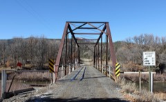 | Labo Del Rio Bridge | structure | 1985 | 85001399 |
Every wildfire the federal occurrence database records inside this county: 1,870 of them, burning about 36,487 acres. 1,321 started naturally and 15 were recorded as arson. Each settlement page carries the fires within five miles of it.
| Reported cause | Fires |
|---|---|
| Natural | 1321 |
| Missing data/not specified/undetermined | 298 |
| Recreation and ceremony | 175 |
| Debris and open burning | 23 |
| Equipment and vehicle use | 19 |
| Arson/incendiarism | 15 |
| Smoking | 11 |
| Power generation/transmission/distribution | 3 |
| Firearms and explosives use | 2 |
| Misuse of fire by a minor | 2 |
| Fireworks | 1 |
The five largest, by the area the report gives. None of them was recorded as arson.
| Date | Cause | Size | Reported by | Name on the report |
|---|---|---|---|---|
| 14 May 2012 | Natural | 24,931 acres | San Juan National Forest | LITTLE SAND |
| 26 July 2003 | Natural | 2,160 acres | Southern Ute Agency | BOLT |
| 23 June 2005 | Natural | 1,182 acres | San Juan National Forest | RIO BLANCO WFU |
| 2 August 2017 | Natural | 1,020 acres | San Juan National Forest | EIGHT FOUR TWO |
| 2 August 2000 | Natural | 796 acres | Southern Ute Agency | CABEZON |
| 25 July 2019 | Natural | 742 acres | Southern Ute Agency | PINE TREE |
| 28 August 2018 | Natural | 710 acres | San Juan National Forest | HORSE |
| 24 August 2011 | Natural | 535 acres | Southern Ute Agency | SAMBRITO 2 |
Every settlement page carries the fires within five miles of it - see the settlement index below.
The NOAA Storm Events Database holds 74 reports for this county, causing 1 death, 7 injuries and about $653,550 in recorded property damage. Each settlement page carries the reports that name it.
| Kind of event | Reports |
|---|---|
| Thunderstorm Wind | 15 |
| Heavy Rain | 13 |
| Lightning | 12 |
| Flash Flood | 8 |
| Hail | 6 |
| Flood | 6 |
| Debris Flow | 6 |
| Wildfire | 5 |
| Funnel Cloud | 2 |
| Tornado | 1 |
The most serious of them, by death, then injury, then recorded damage. The accounts are quoted exactly as the forecast office filed them.
| When | Event | Place named | Harm | What the report says |
|---|---|---|---|---|
| April 1997 | Thunderstorm Wind | Pagosa Spgs | 1 killed, 1 hurt, $5,000 | no account filed |
| July 2021 | Lightning | Chimney Rock | 2 hurt | Three firefighters working during the mopping up stages on the Johnny Canyon Fire east of Baldy Mountain were caught in a thunderstorm near the 9500 foot level. The thunderstorm intensified overhead with heavy rain, hail and continuous lightning. The crew decided to hunker down in place and wait for the storm to pass. After hearing a large thunderclap, the crew decided they needed to move down the mountain to a safer location. While hiking out, the crew passed through a metal fence gate when one firefighter saw a lightning strike very close by. He saw it split between a tree and the metal fence and immediately felt tingling and cramping in his feet and lower back. Another firefighter was in the process of latching the metal fence gate when he felt a jolt go through his harm and his arm tingling. There were no serious injuries between the three firefighters and all refused treatment, even though they were shivering badly and were experiencing the early stages of hypothermia from being exposed to the heavy rain and hail. |
| May 1997 | Thunderstorm Wind | Pagosa Spgs | 1 hurt, $300 | no account filed |
| July 2001 | Lightning | Pagosa Spgs | 1 hurt, $250 | no account filed |
| July 2000 | Lightning | Chromo | 1 hurt | no account filed |
| April 1998 | Lightning | Pagosa Spgs | 1 hurt | no account filed |
| July 2014 | Flash Flood | Pagosa Spgs | $250,000 | Heavy rainfall resulted in flash flooding within various locations in and near Pagosa Springs. Flowing water about 18 inches deep ran across Highway 160 about a half mile east of the junction with Highway 84. A stream which comes down to Rumbaugh Road in northeast Pagosa Springs had a high volume of water which ran across the road and continued onto Highway 160; with water 6 to 8 inches deep in an area generally bounded on the east and west ends by 1st Street and 2nd Street and bounded on the north and south ends by Lewis Street and Highway 160. Another area of flash flooding occurred on the west end of town in the Bastille Drive area where up to a foot of water depth was reported. Water damage occurred to a number of residences and businesses, including an auto supply store which still had about 12 inches of standing water inside the store the next morning. The river gauge in the San Juan River within Pagosa Springs measured a stage rise of just over 3 feet in less than 1.5 hours. The river rose up to the top of the banks in some places but did not overflow. |
| September 2000 | Lightning | Pagosa Spgs | $50,000 | no account filed |
| September 2014 | Thunderstorm Wind | Pagosa Spgs | $45,000 | Hundreds of trees were blown down by thunderstorm outflow winds in the San Juan National Forest, including a large area near County Road 302 in eastern Archuleta County. Live trees up to 3 feet in diameter were snapped off like toothpicks. |
| June 2000 | Lightning | Pagosa Spgs | $40,000 | no account filed |
| April 1998 | Lightning | Pagosa Spgs | $40,000 | no account filed |
| September 2025 | Flash Flood | Arboles | $30,000 | Public reported flash flooding over Archuleta County Road 500/169 Trujillo Road between Arboles and Caracas. There were additional washouts reported near Arboles point, along Trujillo road about 2 miles southeast from the initial LSR location. |
| July 2014 | Flash Flood | Gato | $25,000 | Damage occurred to County Road 500 that was washed out between mile markers 20 and 30 due to a flash flood. The flooding was isolated and included a significant debris flow. |
| September 2017 | Lightning | Lonetree | $20,000 | Lightning struck the Oak Brush communications site and damaged law enforcement communications equipment. |
| August 2010 | Heavy Rain | Pagosa Spgs | $20,000 | Heavy rainfall rates of over an inch per hour were reported in Pagosa Springs which created localized flooding. A number of reports were received of water in homes and stores, and many roads were reported as being covered by standing water. |
| June 2006 | Thunderstorm Wind | Arboles | $15,000 | no account filed |
| July 2001 | Thunderstorm Wind | Pagosa Spgs Arpt | $15,000 | no account filed |
| September 2014 | Hail | Pagosa Spgs | $12,000 | Golfball sized hail was reported by several members of the public just east of Pagosa Springs in a sparsely populated location. Some damage occurred to vehicles. |
| July 1998 | Lightning | Pagosa Spgs | $12,000 | no account filed |
| July 2021 | Debris Flow | Chimney Rock | $10,000 | Heavy rains led to a debris flow across sections of First Fork Road on the Pagosa Ranger District. Portions of the road were washed out. The exact time of the slide is unknown and was estimated based on surrounding observations. |
| June 2008 | Lightning | Pagosa Spgs Arpt | $10,000 | Lightning struck a power supply and left about 550 customers without power for several hours. Electrical crews had to use a backhoe to get at equipment damaged by the strike. |
| April 2006 | Thunderstorm Wind | Pagosa Spgs | $8,000 | no account filed |
| April 2023 | Flood | Chimney Rock | $5,000 | The Piedra River overran its banks due to rapid snowmelt. This led to portions of Colorado Highway 151, south of Chimney Rock National Monument, to be flooded and closed for an extended period of time. |
| August 2022 | Flash Flood | Chromo | $5,000 | Forest Service Road 660, also known as Castle Creek Road, was washed out due to flash flooding as a result of heavy rain from thunderstorms. This resulted in the Fish Creek Trailhead being inaccessible. |
| August 2010 | Thunderstorm Wind | Pagosa Spgs Arpt | $5,000 | Thunderstorm wind gusts toppled a tree near Pagosa Springs, damaging the roof of a house. |
| September 2010 | Thunderstorm Wind | Pagosa Spgs Arpt | $5,000 | Strong thunderstorm outflow winds flipped over two trailers, a flat bed trailer and a utility trailer, as well as some mature pine trees in the vicinity of Stevens Field Airport near Pagosa Springs. The AWOS at the airport measured gusts to 58 mph. There were no known eyewitnesses to this damaging wind event since it occurred shortly after midnight. |
| April 2010 | Flood | Chimney Rock | $5,000 | Stollsteimer Creek ran out of its banks in some places within the Aspen Springs subdivision west of Pagosa Springs, which inundated some foot bridges and flooded a trailer that was flooded. A portion of County Road 359 was also washed out due to flowing water exceeding the capacity of a 4 foot diameter culvert underneath the road. Additionally, the Navajo River also flowed out of its banks near the confluence of the Navajo and San Juan Rivers along County Road 551. |
| May 1994 | Thunderstorm Wind | Pagosa Springs | $5,000 | Thunderstorm winds toppled over a tractor semi-trailer and blew off half of a hotel roof in Pagosa Springs (36 miles east of Durango). |
| April 1997 | Thunderstorm Wind | Pagosa Spgs | $4,500 | no account filed |
| September 2025 | Flash Flood | Chimney Rock | $4,000 | National Park Service employees based at Chimney Rock National Monument reported flash flooding on State Route 151 between Pagosa Springs and Arboles. Additionally, washouts and debris were reported in the Chimney Rock National Monument itself, with the LSR reading Upper road and parking lots impassable. Chimney Rock National Monument had to be closed the following day (September 13th, 2025) to clear debris. |
| April 2023 | Flood | Pagosa Spgs Arpt | $2,500 | The Pagosa Ranger District in the San Juan National Forest reported at least three instances of flooding on Piedra Road (CR 600) north of the Turkey Springs Trailhead. The flooding was the result of rapid runoff from snowmelt. |
| July 2022 | Debris Flow | Chimney Rock | $1,000 | Several spots of mud and debris crossed Colorado Highway 160 by Capote Lake as a result of heavy rain from thunderstorms. Rainfall totals exceeded 1 inch. |
| April 1999 | Tornado (F0) | Pagosa Spgs | $1,000 | no account filed |
| July 1998 | Flash Flood | Chromo | $1,000 | no account filed |
| August 2022 | Debris Flow | Chimney Rock | $500 | Heavy rain caused flash flooding at mile marker 130 on Colorado Highway 160, triggering a mudslide with 6 to 8 inches of water and mud running across the highway. |
| April 1999 | Lightning | Pagosa Spgs | $500 | no account filed |
| April 1999 | Thunderstorm Wind | Arboles | $500 | no account filed |
| July 1998 | Lightning | Pagosa Spgs | $500 | no account filed |
| June 2025 | Debris Flow | Arboles | - | At approximately 6:20 PM MDT, a severe thunderstorm moved southwest of Chimney Rock National Monument, producing heavy rain and hail. This heavy rain fell on an area of very steep terrain and produced a mud flow and small rock slide across Colorado Highway 151. Aside from the road needing to be cleared, no damage, injuries, or fatalities were reported in association with this debris flow. |
| October 2025 | Flood | Pagosa Spgs | - | Significant rainfall fell across the San Juan River Basin between the evening of October 9 and October 11 due to the remnants of Tropical Storm Priscilla. This resulted in major flooding along the San Juan River in Pagosa Springs. Action stage of 9.48 feet was exceeded on October 11 at 1100 MST. The San Juan River crested at major flood stage on October 11 at 1600 MST at 12.66 feet and 8270 cfs. The San Juan River then fell to near action stage on October 12 at 1000 MST. Four places were impacted in Archuleta County which were mostly rural. Most of the damage reported were dirt roads washed out and minor flooding to residents where the river exceeded its banks. There were numerous power outages and a water main broke in Pagosa Springs which was repaired on October 12. Preliminary estimates of $5 million to repair man-made white water rapids for kayaking and recreation along the San Juan River in Pagosa Springs and $2 million estimated to repair the bike path along the San Juan River in Pagosa Springs. |
| October 2025 | Flood | Pagosa Spgs | - | The San Juan River reached a second crest to major flood stage that was even higher than the first in response to additional significant rainfall and locally heavier rates on October 13. This heavy rainfall was due to the remnants of Tropical Storm Raymond on top of already saturated ground from the previous surge from Tropical Storm Priscilla. The San Juan River climbed back to action stage on October 13 at 1300 MST at 9.48 feet. The second crest reached major flood stage on October 14 at 300 MST at 12.88 feet. The San Juan River then fell below action stage on October 15 at 700 MST. |
| October 2025 | Flood | Arboles | - | The Piedra River had a rapid rise in levels throughout the morning and afternoon of October 11th due to abundant rainfall starting on October 10th. It first crested to a preliminary level of 5.86 ft around midnight 10/12. A second crest occurred to a preliminary level of 7.26 ft on 10/14 around 1300 MST. This set a new record, beating the previous crest record of 6.4 ft which was set back on 9/6/1970. Most issues were adjacent to the 151 corridor north of Arboles where numerous drives were under water, one garage had some water in it. Forest Service Rd 613 did have some inundation but most bridges had several feet of clearance. USFS 613 which is parallel to the river did have water in some areas. |
| July 2024 | Debris Flow | Chimney Rock | - | Heavy rain from strong thunderstorms resulted in a rock slide across Highway 151 in an area between the intersection of Forest Service Road 618 and Highway 160. Colorado Highway 151 was closed in both directions due to the rock slide between mile markers 32 and 33. |
| May 2020 | Thunderstorm Wind | Pagosa Spgs Arpt | - | The automated weather station at the Stevens Field Airport in Pagosa Springs recorded a peak wind gust of 59 MPH from a severe thunderstorm. |
| July 2018 | Heavy Rain | Chimney Rock | - | A minor debris flow occurred over Colorado Highway 151 at mile marker 28 as a result of heavy rain. Radar estimates showed half an inch to an inch of rain fell within an hour in that area. |
| July 2018 | Heavy Rain | Pagosa Spgs | - | Within 15 minutes, 0.64 of an inch of rain fell at a location 10 miles southeast of Pagosa Springs. |
| July 2018 | Heavy Rain | Chromo | - | Within 30 minutes, 0.70 inches of rain fell. |
| July 2018 | Debris Flow | Chimney Rock | - | A mudslide occurred along Colorado Highway 160 at mile marker 124 as a result of heavy rain. Vehicles were stuck in deep mud with traffic backed up on either side of the highway. The highway was closed in both directions for almost 4 hours with about 100 vehicles backed up on either side of the mudslide area. Radar estimates showed half an inch to an inch of rainfall within an hour in that area. |
| July 2017 | Heavy Rain | Pagosa Spgs Arpt | - | A three-hour rainfall event produced 0.65 of an inch of rain and pea-sized hail. |
| August 2016 | Hail | Pagosa Spgs Arpt | - | Quarter-sized hail was observed at Stevens Field Airport. |
| July 2014 | Heavy Rain | Chromo | - | A rainfall total of 1.26 inches fell within a two hour period, with most of the precipitation having occurred in less than one hour. |
| April 2012 | Hail | Pagosa Spgs | - | Large hail was reported and photographed by a person who also reported some graupel, wet snow and a little rain from the same storm cell. |
| August 2010 | Heavy Rain | Pagosa Spgs | - | Heavy rainfall caused a minor mudslide across Highway 160 just north of Pagosa Springs. The slide was about 6 to 8 feet wide and up to two and a half feet deep at its deepest sections. Rainfall amounts up to 0.50 inches within a 20 minute time period were reported just west of Pagosa Springs. |
| August 2008 | Funnel Cloud | Chromo | - | Two simultaneous funnel clouds were observed by many eyewitnesses in eastern Archuleta County. |
| August 2007 | Flash Flood | Pagosa Spgs | - | Heavy rainfall caused flash flooding along the Rio Blanco River. Water up to 6 inches deep flowed across County Road 326. Big boulders were being moved by the water along with mud and other debris. |
| August 1993 | Thunderstorm Wind | Pagosa Springs | - | A spotter reported a thunderstorm wind gust to 58 mph (50 knots) just east of Pagosa Springs. |
| September 2013 | Hail | Arboles | - | no account filed |
| August 2006 | Heavy Rain | Pagosa Spgs | - | no account filed |
| September 2005 | Heavy Rain | Pagosa Spgs | - | no account filed |
| November 2005 | Thunderstorm Wind | Arboles | - | no account filed |
The Survey's mineral resources record lists 34 workings inside this county. 5 still produce and 29 are closed or unrecorded. Each settlement page carries the workings within five miles of it.
| Commodity | Workings |
|---|---|
| Sand and Gravel, Construction | 13 |
| Feldspar | 5 |
| Calcium | 3 |
| Uranium | 2 |
| Silver, Lead, Copper | 2 |
| Gold | 2 |
| Silver, Lead, Copper, Gold | 1 |
| Molybdenum, Silver, Lead, Copper | 1 |
| Silver, Lead, Zinc | 1 |
| Gold, Copper | 1 |
| Uranium, Vanadium | 1 |
| Radium, Gypsum-Anhydrite | 1 |
| Lead, Copper, Gold, Silver | 1 |
| Zinc, Copper, Lead, Silver | 1 |
The least common of them first, because a county's hundredth gravel pit says nothing its first ten did not.
| Where | Site | Commodity | Status | Recorded |
|---|---|---|---|---|
| Banded Peak District | Silver, Lead, Zinc, Gold, Copper | Occurrence | 1875 | |
| Copper Queen | Gold, Copper, Lead, Silver, Zinc | Past Producer | ||
| Pagosa Springs | Geothermal | Producer | ||
| Sunetha Anticline Claims | Uranium, Vanadium | Prospect | ||
| Sunetha Claim Group | Uranium, Vanadium | Occurrence | Carnotite | |
| Treasure-Comstock | Gold, Zinc, Copper, Lead, Silver | Past Producer | ||
| Unknown | Radium, Gypsum-Anhydrite | Occurrence | Sedimentary | |
| Unnamed Silver-Lead Occurrence | Silver, Lead, Copper, Gold | Occurrence | 1975 | |
| Unnamed Silver-Lead-Copper Occurrence | Lead, Copper, Gold, Silver | Occurrence | 1975 | |
| Unnamed Silver-Lead-Copper-Molybdenum Occurrence | Molybdenum, Silver, Lead, Copper | Occurrence | 1975 | |
| Sunetha Anticline | Uranium | Occurrence | Carnotite | |
| Unnamed Prospect | Silver, Lead, Copper | Occurrence | Vein | |
| Unnamed Silver-Lead-Copper Occurrence | Silver, Lead, Copper | Occurrence | 1975 | |
| Meadows Property | Calcium | Occurrence | 1938, 1941 | |
| Oak Grove Ranch Property | Calcium | Occurrence | Vein | |
| Seavy Ranch Property | Calcium | Occurrence | 1938, 1941 | |
| Iceland Spar | Feldspar | Past Producer | ||
| Meadows Property | Feldspar | Past Producer | ||
| Meadows Property | Feldspar | Past Producer | ||
| Oak Grove Ranch | Feldspar | Unknown | ||
| Seavy Ranch | Feldspar | Past Producer | ||
| Paul Day Pit | Sand and Gravel, Construction | Producer | ||
| Unknown | Sand and Gravel, Construction | Occurrence | Sand and Gravel | |
| Unknown | Sand and Gravel, Construction | Producer | Sand and Gravel | |
| Unknown | Sand and Gravel, Construction | Occurrence | Sand and Gravel | |
| Unknown | Sand and Gravel, Construction | Producer | Gravel | |
| Unknown | Sand and Gravel, Construction | Occurrence | Sand and Gravel | |
| Unknown | Sand and Gravel, Construction | Occurrence | Sand and Gravel | |
| Unknown | Sand and Gravel, Construction | Occurrence | Sand and Gravel | |
| Unknown | Sand and Gravel, Construction | Occurrence | Sand and Gravel | |
| Unknown | Sand and Gravel, Construction | Occurrence | Sand and Gravel | |
| Unknown | Sand and Gravel, Construction | Occurrence | Sand and Gravel | |
| Unknown | Sand and Gravel, Construction | Occurrence | Sand and Gravel | |
| Unknown | Sand and Gravel, Construction | Producer | Sand and Gravel |
Named settlements recorded in the Geographic Names Information System, each with the topographic sheets covering it. Villages, hamlets and abandoned places alike. Each is shown with the nearest named watercourse or landform and the survey quadrangle it falls on.
Arboles census division · 81147 · Near Tio Quinto Canyon · Carracas quadrangle
23 sheets, 1924 to 1983
Arboles census division · 81122 · On Yellowjacket Creek · Chimney Rock quadrangle
17 sheets, 1924 to 1983
No longer a settlement
Pagosa Springs census division · 81147 · On Little Navajo River · Chromo quadrangle
24 sheets, 1913 to 1985
Arboles census division · 81147 · Near Hall Canyon · Lonetree Canyon quadrangle
21 sheets, 1924 to 1984
Pagosa Springs census division · 81147 · Near Abeyta Canyon · Edith quadrangle
24 sheets, 1913 to 1985
Arboles census division · 81147 · Near Cañada de la Nutrita · Pagosa Junction quadrangle
22 sheets, 1924 to 1984
Pagosa Springs census division · 81147 · On Navajo River · Pagosa Junction quadrangle
22 sheets, 1924 to 1984
Pagosa Springs census division · 81147 · Near West Kearns Canyon · Lonetree Canyon quadrangle
21 sheets, 1924 to 1984
Pagosa Springs census division · 81147 · In Lonetree Canyon · Lonetree Canyon quadrangle
21 sheets, 1924 to 1984
Arboles census division · 81147 · Near Martinez Canyon · Lonetree Canyon quadrangle
21 sheets, 1924 to 1984
Pagosa Springs census division · 81147 · On Cat Creek · Pagosa Junction quadrangle
22 sheets, 1924 to 1984
Pagosa Springs census division · 81147 · On McCabe Creek · Pagosa Springs quadrangle
19 sheets, 1924 to 1983
Arboles census division · 81122 · On Yellowjacket Creek · Chimney Rock quadrangle
17 sheets, 1924 to 1983
Arboles census division · 81147 · On Stollsteimer Creek · Chimney Rock quadrangle
17 sheets, 1924 to 1983
Pagosa Springs census division · 81147 · On Fourmile Creek · Jackson Mountain quadrangle
27 sheets, 1913 to 1985
Pagosa Springs census division · 81147 · Near Salt Canyon · Trujillo quadrangle
21 sheets, 1924 to 1984
The vanished settlements of Archuleta County: the places named above that are no longer on the map.