 Block
From the record
8 National Register listings published here.
Sources: the National Register database, National Park Service
63 topographic sheets cover 25 settlements here, and 8 properties are on the National Register of Historic Places.
8 National Register listings published here.
Sources: the National Register database, National Park Service
Every property in this county listed on the National Register of Historic Places, with the year it was listed and the federal nomination document.
| Photograph | Property | Type | Listed | Reference |
|---|---|---|---|---|
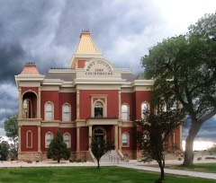 | Bent County Courthouse and Jail | building | 1976 | 76000546 |
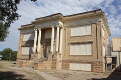 | Bent County High School | building | 2010 | 10000505 |
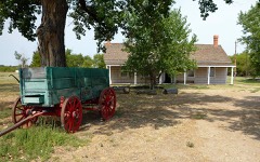 | Boggsville | district | 1986 | 86002841 |
| Boggsville (Boundary Increase) | district | 2022 | 100005980 | |
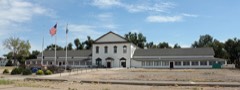 | Fort Lyon | district | 2004 | 04000388 |
 | Fort Lyon National Cemetery | district | 2017 | 100000472 |
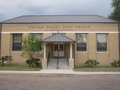 | Las Animas Post Office | building | 2008 | 07001392 |
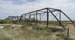 | Prowers Bridge | structure | 1985 | 85000189 |
Every wildfire the federal occurrence database records inside this county: 233 of them, burning about 22,715 acres. 7 started naturally and 2 were recorded as arson. Each settlement page carries the fires within five miles of it.
| Reported cause | Fires |
|---|---|
| Missing data/not specified/undetermined | 172 |
| Debris and open burning | 27 |
| Equipment and vehicle use | 11 |
| Smoking | 9 |
| Natural | 7 |
| Recreation and ceremony | 4 |
| Arson/incendiarism | 2 |
| Other causes | 1 |
The five largest, by the area the report gives. None of them was recorded as arson.
| Date | Cause | Size | Reported by | Name on the report |
|---|---|---|---|---|
| 9 April 2011 | Missing data/not specified/undetermined | 14,726 acres | Colorado State Forest Service-State Headquarters | LAS ANIMAS |
| 3 June 2011 | Natural | 4,500 acres | Bent County Office | SALT |
| 4 April 2019 | Missing data/not specified/undetermined | 1,487 acres | Colorado State Forest Service-State Headquarters | BLACK BRIDGE |
| 30 April 2020 | Equipment and vehicle use | 250 acres | Bent County Office | MCCLAVE BRIDGE |
| 3 May 2010 | Missing data/not specified/undetermined | 200 acres | Colorado State Forest Service-State Headquarters | not named |
| 2 March 2011 | Missing data/not specified/undetermined | 200 acres | Colorado State Forest Service-State Headquarters | LAS ANIMAS |
| 16 June 2020 | Missing data/not specified/undetermined | 200 acres | Bent County Office | HWY 50 CNTY RD 19/20 |
| 14 March 2018 | Missing data/not specified/undetermined | 200 acres | Wiley Fire Department | UNKNOWN |
Every settlement page carries the fires within five miles of it - see the settlement index below.
The NOAA Storm Events Database holds 290 reports for this county, causing 1 death, 9 injuries and about $7,987,000 in recorded property damage. Each settlement page carries the reports that name it.
| Kind of event | Reports |
|---|---|
| Hail | 170 |
| Tornado | 50 |
| Thunderstorm Wind | 48 |
| Flash Flood | 12 |
| Funnel Cloud | 4 |
| Flood | 4 |
| Heavy Rain | 2 |
The most serious of them, by death, then injury, then recorded damage. The accounts are quoted exactly as the forecast office filed them.
| When | Event | Place named | Harm | What the report says |
|---|---|---|---|---|
| August 1997 | Thunderstorm Wind | Mc Clave | 1 killed, 1 hurt, $80,000 | A damaging microburst wind, estimated to be at least 115 mph in strength struck a mobile home, rolling it a few hundred yards. The intense damage was 50 to 75 yards across. Twin brothers, Dan and Denton Cochell were in the mobile home. Dan was thrown from the mobile home and sustained a broken eye socket. Denton was rolled inside the mobile home, sustaining numerous injuries to his body, neck, and head. He died six days later. |
| October 1997 | Tornado (F1) | Las Animas | 6 hurt, $200,000 | no account filed |
| June 2004 | Tornado (F1) | Las Animas | 1 hurt, $1,000,000 | A tornado caused severe damage to at least seven buildings at Mountain Prairie Hog Farms. Seven farrowing barns (380 feet x 60 feet) were destroyed. Only one pig was killed. A fire started in one of the structures when a gas line broke. Debris was scattered a few miles east southeast of the Farms. |
| June 2004 | Tornado (F2) | Las Animas | 1 hurt, $100,000 | A tornado struck a ranch destroying the house, and damaging other buildings and two mobile homes. The family of five sought shelter in an interior closet, and the lone injury was the mother, who suffered a minor gash on her forehead. |
| June 2001 | Hail | Ft Lyon | $6,000,000 | A slow moving very severe thunderstorm brought very heavy rain, causing flooding, and hail around baseball size to the Ft. Lyon area for nearly an hour. Highway 50 was under water for over an hour near Ft. Lyon. Many residences experienced basement flooding. The large hail broken out windows and destroyed roofs on houses. Many vehicles also sustained major damage. The VA Medical Center's tile roof was completely destroyed, along with many windows. The grounds also sustained major damage. In addition, crops were totally destroyed in the area. Damage estimates were still preliminary at the time of submission. |
| June 2006 | Hail | Hasty | $150,000 | no account filed |
| July 2001 | Thunderstorm Wind | Las Animas | $100,000 | Damaging thunderstorm winds downed 1 1/2 miles of power poles along Highway 101 around 7 miles south of Las Animas in Bent county. It took around 2 to 3 weeks to replace the poles. |
| August 1996 | Thunderstorm Wind | Las Animas | $75,000 | no account filed |
| June 2004 | Thunderstorm Wind | Las Animas | $50,000 | Strong rear flank downdraft winds caused damage to horse barns and knocked down around 40 power poles along highway 101. This rear flank downdraft later tightening a circulation which caused a tornado at a ranch in extreme south central Bent county. |
| June 1995 | Tornado (F0) | Las Animas | $50,000 | Tornado downed some power lines in open country in northern part of county, but no other known damage. |
| October 1997 | Hail | Las Animas | $50,000 | no account filed |
| April 2012 | Tornado (EF2) | Mc Clave | $25,000 | Two locations experienced heavy damage. On State Highway 196 a metal building was destroyed and a home damaged...and four metal power poles were bent over. On County Road PP a metal barn was damaged and horse corrals were destroyed. One horse was killed. |
| May 1975 | Tornado (F1) | not stated | $25,000 | no account filed |
| June 2016 | Thunderstorm Wind | Las Animas | $20,000 | Large cottonwood trees, taller than 25 feet, were uprooted at the Las Animas golf course. |
| October 1997 | Tornado (F1) | Las Animas | $20,000 | A line of thunderstorms moving east through western Bent county merged with a northeast moving supercell thunderstorm just west of Las Animas. The hail quickly grew from one inch in diameter up to 4.50 inches in diameter. A tornado and high winds skipped across the landscape for about 8 miles from about 3 miles west northwest of Las Animas through ranch country of north central Bent county. Windows were broken and roofs were destroyed on houses, outbuilding were damaged and destroyed, and vehicles were damaged and destroyed by both the high winds and hail. |
| August 2004 | Tornado (F0) | Hasty | $10,000 | A brief tornado tracked northwest of Hasty and destroyed a garage. |
| June 2006 | Thunderstorm Wind | Las Animas | $7,000 | Damaging thunderstorm winds caused 10 power poles to go down, and knocked a semi-trailer on its side on Highway 101. |
| June 2022 | Tornado (EF0) | Ft Lyon | $5,000 | A tornado was confirmed by an induvial who picked up in a truck, rotated 120 degrees, had his windows blown out, and mirrors ripped off. He reported that the tornado was roughly the size of truck. He also reported power lines down. This was confirmed by local authorities. |
| July 2011 | Thunderstorm Wind | Mc Clave | $5,000 | A roof was partially ripped off a barn. |
| August 2002 | Thunderstorm Wind | Las Animas | $3,000 | no account filed |
| June 1989 | Tornado (F1) | not stated | $2,500 | no account filed |
| July 1979 | Tornado (F0) | not stated | $2,500 | no account filed |
| May 1975 | Tornado (F2) | not stated | $2,500 | no account filed |
| June 1962 | Tornado (F2) | not stated | $2,500 | no account filed |
| June 2011 | Thunderstorm Wind | Las Animas | $1,000 | Two power poles were snapped off. |
| July 1994 | Hail | Las Animas | $500 | Dime-size hail damaged crops near Las Animas. One farmer reported several rain gages were destroyed by the hail. |
| June 1957 | Tornado | not stated | $250 | no account filed |
| July 1956 | Tornado | not stated | $250 | no account filed |
| August 2025 | Hail | Caddoa | - | Hail measured to 1.5 inches fell in eastern Bent County. |
| August 2025 | Hail | Caddoa | - | Hail measured to 1.5 inches fell in eastern Las Animas County. |
| August 2025 | Hail | Caddoa | - | Hail measured to 2 inches fell in central Bent County. |
| August 2025 | Hail | Caddoa | - | Hail measured to 1.25 inches fell in eastern Bent County. |
| July 2025 | Hail | Las Animas | - | Report from mPING. Hail measured to 1.25 inches occurred in Bent County. |
| May 2024 | Hail | Las Animas | - | A trained spotter reported hail of 1.5 inches in diameter. |
| May 2024 | Hail | Las Animas | - | A trained spotter reported quarter size hail, with a few bigger stones estimated at 1.5 inches in diameter. |
| May 2024 | Hail | Las Animas | - | A public source reported hail of 1 inch in diameter. |
| May 2024 | Hail | Ft Lyon | - | A public source located on County Road 14, north of Highway 50, reported hail of 1 inch in diameter. |
| May 2024 | Hail | Las Animas | - | A NWS employee reported hail the size of 1.25 inches in diameter. |
| July 2024 | Thunderstorm Wind | Hasty | - | Large tree limbs blown down with minor damage to camping trailers from limb impalement. |
| July 2023 | Thunderstorm Wind | Las Animas | - | Estimated Winds. |
| July 2023 | Thunderstorm Wind | Las Animas | - | Window on northside of the house blew out due to wind and hail. |
| July 2023 | Flash Flood | Las Animas | - | Reports of flooding reaching to the doors of homes. Some roads were impassable due to high water. |
| June 2023 | Thunderstorm Wind | Las Animas | - | Small limb damage also reported. |
| June 2023 | Hail | Ft Lyon | - | Reported by Law Enforcement. |
| June 2023 | Hail | Caddoa | - | Reported by an NWS Employee, with the time estimated with radar. |
| May 2022 | Hail | Ft Lyon | - | Trained spotter reported one inch hail with the severe storm that moved through the Fort Lyon area. |
| May 2022 | Hail | Ft Lyon | - | Quarter size hail along Highway 50, just east of Fort Lyon. |
| August 2022 | Thunderstorm Wind | Mc Clave | - | Structure thrown onto road. |
| August 2022 | Funnel Cloud | Mc Clave | - | Weather spotter reported visually seeing a funnel cloud appear the dissipate. Wall cloud was still visible at the time of the report. |
| August 2022 | Flash Flood | Las Animas | - | Colorado DOT reports flooding on Highway 50 near mile marker 394 (between county road 5.5 and county road 6.25). |
| July 2022 | Heavy Rain | Hasty | - | Heavy rainfall of 1.12 inches. |
| July 2022 | Heavy Rain | Las Animas | - | Heavy rainfall of 1.5 inches. |
| June 2022 | Tornado (EFU) | Las Animas | - | Storm Chaser showed pictures of tornado via social media. |
| June 2022 | Hail | Las Animas | - | Spotter reported one-inch hail. |
| June 2022 | Hail | Las Animas | - | Local Law Enforcement reported one-inch hail. |
| June 2022 | Tornado (EFU) | Hasty | - | Photo evidence of a tornado associated with the occlusion of the circulation south of the earlier bent county tornadic circulation. tornado lasted approximately 5 minutes, starting at 5:43 pm mdt, as viewed by multiple individuals looking west, to the south of Wiley, CO. |
| June 2022 | Tornado (EFU) | Las Animas | - | Initial updrafts of developing thunderstorms interacted with an outflow boundary and produced a landspout tornado, which was on the ground for approximately 10-15 mins. Numerous photos on social media showed a dusty landspout. This preceded the development of a mesocyclonic tornado farther east. |
| May 2021 | Thunderstorm Wind | Caddoa | - | Power pole blown down 4 miles southeast Caddoa. |
| May 2021 | Tornado (EFU) | Mc Clave | - | Tornado on the ground, west of Wiley. |
| July 2020 | Hail | Hasty | - | Near Hasty. |
The Survey's mineral resources record lists 103 workings inside this county. 2 still produce and 101 are closed or unrecorded. Each settlement page carries the workings within five miles of it.
| Commodity | Workings |
|---|---|
| Sand and Gravel, Construction | 70 |
| Stone, Crushed/Broken | 14 |
| Clay | 7 |
| Uranium | 6 |
| Fire Clay (Refractory) | 5 |
| Copper | 1 |
| Limestone, General | 1 |
The least common of them first, because a county's hundredth gravel pit says nothing its first ten did not.
| Where | Site | Commodity | Status | Recorded |
|---|---|---|---|---|
| Allen Jones Property | Copper, Uranium | Past Producer | ||
| The Marlman Limestone Quarry | Limestone, General | Producer | Limestone | |
| Unknown | Fire Clay (Refractory) | Occurrence | ||
| Unknown | Fire Clay (Refractory) | Occurrence | ||
| Unknown | Fire Clay (Refractory) | Occurrence | ||
| Unknown | Fire Clay (Refractory) | Occurrence | ||
| Unknown | Fire Clay (Refractory) | Occurrence | ||
| Allen Jones | Uranium | Past Producer | ||
| G.R. Acton Property | Uranium | Occurrence | ||
| Hansen Ranch Uranium Occurrence | Uranium | Occurrence | ||
| Unknown | Uranium | Occurrence | ||
| Unnamed Uranium Occurrence | Uranium | Occurrence | ||
| Bentco | Clay | Past Producer | ||
| Unk | Clay | Unknown | ||
| Unk | Clay | Unknown | ||
| Unk | Clay | Unknown | ||
| Unk | Clay | Unknown | ||
| Unk | Clay | Unknown | ||
| Unk | Clay | Unknown | ||
| Marlman Quarry | Stone, Crushed/Broken | Unknown | ||
| Marlman Quarry | Stone, Crushed/Broken | Past Producer | ||
| Unk | Stone, Crushed/Broken | Unknown | ||
| Unk | Stone, Crushed/Broken | Past Producer | ||
| Unk | Stone, Crushed/Broken | Past Producer | ||
| Unk | Stone, Crushed/Broken | Unknown | ||
| Unk | Stone, Crushed/Broken | Unknown | ||
| Unk | Stone, Crushed/Broken | Unknown | ||
| Unknown | Stone, Crushed/Broken | Occurrence | Sedimentary | |
| Unknown | Stone, Crushed/Broken | Occurrence | Sedimentary | |
| Unknown | Stone, Crushed/Broken | Occurrence | Sedimentary | |
| Unknown | Stone, Crushed/Broken | Occurrence | Sedimentary | |
| Unknown | Stone, Crushed/Broken | Occurrence | Sedimentary | |
| Unknown | Stone, Crushed/Broken | Occurrence | Sedimentary | |
| Bent Builders | Sand and Gravel, Construction | Producer | ||
| Unk | Sand and Gravel, Construction | Unknown | ||
| Unk | Sand and Gravel, Construction | Unknown | ||
| Unk | Sand and Gravel, Construction | Unknown | ||
| Unk | Sand and Gravel, Construction | Unknown | ||
| Unk | Sand and Gravel, Construction | Unknown | ||
| Unk | Sand and Gravel, Construction | Unknown | ||
| Unk | Sand and Gravel, Construction | Unknown | ||
| Unk | Sand and Gravel, Construction | Unknown | ||
| Unk | Sand and Gravel, Construction | Unknown | ||
| Unk | Sand and Gravel, Construction | Unknown | ||
| Unk | Sand and Gravel, Construction | Unknown | ||
| Unk | Sand and Gravel, Construction | Unknown | ||
| Unk | Sand and Gravel, Construction | Unknown | ||
| Unk | Sand and Gravel, Construction | Unknown | ||
| Unk | Sand and Gravel, Construction | Unknown | ||
| Unk | Sand and Gravel, Construction | Unknown | ||
| Unk | Sand and Gravel, Construction | Unknown | ||
| Unk | Sand and Gravel, Construction | Unknown | ||
| Unk | Sand and Gravel, Construction | Unknown | ||
| Unk | Sand and Gravel, Construction | Unknown | ||
| Unk | Sand and Gravel, Construction | Unknown | ||
| Unk | Sand and Gravel, Construction | Unknown | ||
| Unk | Sand and Gravel, Construction | Unknown | ||
| Unk | Sand and Gravel, Construction | Unknown | ||
| Unk | Sand and Gravel, Construction | Unknown | ||
| Unk | Sand and Gravel, Construction | Unknown | ||
| Unk | Sand and Gravel, Construction | Unknown | ||
| Unk | Sand and Gravel, Construction | Unknown | ||
| Unk | Sand and Gravel, Construction | Unknown | ||
| Unk | Sand and Gravel, Construction | Unknown | ||
| Unk | Sand and Gravel, Construction | Unknown | ||
| Unk | Sand and Gravel, Construction | Unknown | ||
| Unk | Sand and Gravel, Construction | Unknown | ||
| Unk | Sand and Gravel, Construction | Unknown | ||
| Unk | Sand and Gravel, Construction | Unknown | ||
| Unk | Sand and Gravel, Construction | Unknown | ||
| Unk | Sand and Gravel, Construction | Unknown | ||
| Unk | Sand and Gravel, Construction | Unknown | ||
| Unk | Sand and Gravel, Construction | Unknown | ||
| Unk | Sand and Gravel, Construction | Unknown | ||
| Unknown | Sand and Gravel, Construction | Occurrence | Gravel | |
| Unknown | Sand and Gravel, Construction | Occurrence | Gravel | |
| Unknown | Sand and Gravel, Construction | Occurrence | Gravel | |
| Unknown | Sand and Gravel, Construction | Occurrence | Gravel | |
| Unknown | Sand and Gravel, Construction | Occurrence | Gravel | |
| Unknown | Sand and Gravel, Construction | Occurrence | Gravel | |
| Unknown | Sand and Gravel, Construction | Occurrence | Gravel | |
| Unknown | Sand and Gravel, Construction | Occurrence | Gravel | |
| Unknown | Sand and Gravel, Construction | Occurrence | Gravel | |
| Unknown | Sand and Gravel, Construction | Occurrence | Gravel | |
| Unknown | Sand and Gravel, Construction | Occurrence | Gravel | |
| Unknown | Sand and Gravel, Construction | Occurrence | Gravel | |
| Unknown | Sand and Gravel, Construction | Occurrence | Gravel | |
| Unknown | Sand and Gravel, Construction | Occurrence | Gravel | |
| Unknown | Sand and Gravel, Construction | Occurrence | Gravel | |
| Unknown | Sand and Gravel, Construction | Occurrence | Gravel | |
| Unknown | Sand and Gravel, Construction | Occurrence | Gravel | |
| Unknown | Sand and Gravel, Construction | Occurrence | Gravel | |
| Unknown | Sand and Gravel, Construction | Occurrence | Gravel | |
| Unknown | Sand and Gravel, Construction | Occurrence | Gravel | |
| Unknown | Sand and Gravel, Construction | Occurrence | Gravel | |
| Unknown | Sand and Gravel, Construction | Occurrence | Gravel | |
| Unknown | Sand and Gravel, Construction | Occurrence | Gravel | |
| Unknown | Sand and Gravel, Construction | Occurrence | Gravel | |
| Unknown | Sand and Gravel, Construction | Occurrence | Gravel | |
| Unknown | Sand and Gravel, Construction | Occurrence | Gravel | |
| Unknown | Sand and Gravel, Construction | Occurrence | Gravel | |
| Unknown | Sand and Gravel, Construction | Occurrence | Gravel | |
| Unknown | Sand and Gravel, Construction | Occurrence | Gravel |
Named settlements recorded in the Geographic Names Information System, each with the topographic sheets covering it. Villages, hamlets and abandoned places alike. Each is shown with the nearest named watercourse or landform and the survey quadrangle it falls on.
Las Animas census division · 81054 · Near John Donlon Draw · Las Animas quadrangle
18 sheets, 1891 to 1981
South Bent census division · 81052 · Prowers quadrangle
17 sheets, 1892 to 1988
South Bent census division · 81054 · Near Ninemile Hill · Gilpin quadrangle
16 sheets, 1891 to 1982
South Bent census division · 81054 · Near Picketwire Valley · Las Animas quadrangle
18 sheets, 1891 to 1981
Las Animas census division · 81054 · On Gageby Creek · Kreybill quadrangle
16 sheets, 1891 to 1981
South Bent census division · 81054 · On Purgatoire River · Las Animas quadrangle
18 sheets, 1891 to 1981
McClave census division · 81052 · On Graveyard Creek · Prowers quadrangle
17 sheets, 1892 to 1988
South Bent census division · 81052 · On Graveyard Creek · Prowers quadrangle
17 sheets, 1892 to 1988
South Bent census division · 81054 · In Ruxton Draw · Ninaview quadrangle
15 sheets, 1891 to 1982