 Block
From the record
1 National Register listing published here.
Sources: the National Register database, National Park Service
36 topographic sheets cover 6 settlements here, and 1 property is on the National Register of Historic Places.
1 National Register listing published here.
Sources: the National Register database, National Park Service
Every property in this county listed on the National Register of Historic Places, with the year it was listed and the federal nomination document.
| Photograph | Property | Type | Listed | Reference |
|---|---|---|---|---|
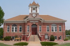 | Crowley School | building | 1999 | 99000897 |
Every wildfire the federal occurrence database records inside this county: 121 of them, burning about 9,612 acres. 7 started naturally and 5 were recorded as arson. Each settlement page carries the fires within five miles of it.
| Reported cause | Fires |
|---|---|
| Missing data/not specified/undetermined | 72 |
| Debris and open burning | 16 |
| Equipment and vehicle use | 9 |
| Natural | 7 |
| Smoking | 6 |
| Recreation and ceremony | 6 |
| Arson/incendiarism | 5 |
The five largest, by the area the report gives. One of them was set deliberately.
| Date | Cause | Size | Reported by | Name on the report |
|---|---|---|---|---|
| 15 April 2008 | Missing data/not specified/undetermined | 8,900 acres | Pueblo Interagency Dispatch Center | ORDWAY CROWLEY CO |
| 23 March 2011 | Missing data/not specified/undetermined | 300 acres | Colorado State Forest Service-State Headquarters | SUGAR CITY |
| 7 August 1995 | Natural | 160 acres | Crowley County | not named |
| 1 May 2015 | Debris and open burning | 90 acres | Ordway Volunteer Fire Department | UNKNOWN |
| 3 January 2016 | Arson/incendiarism | 50 acres | Ordway Volunteer Fire Department | UNKNOWN |
| 30 October 2010 | Missing data/not specified/undetermined | 15 acres | Colorado State Forest Service-State Headquarters | not named |
| 10 March 1995 | Debris and open burning | 10 acres | Otero County | not named |
| 13 March 2015 | Equipment and vehicle use | 8.0 acres | Ordway Volunteer Fire Department | UNKNOWN |
Every settlement page carries the fires within five miles of it - see the settlement index below.
The NOAA Storm Events Database holds 157 reports for this county, causing no deaths, 5 injuries and about $68,800 in recorded property damage. Each settlement page carries the reports that name it.
| Kind of event | Reports |
|---|---|
| Hail | 107 |
| Thunderstorm Wind | 25 |
| Tornado | 17 |
| Flash Flood | 5 |
| Funnel Cloud | 1 |
| Lightning | 1 |
| Heavy Rain | 1 |
The most serious of them, by death, then injury, then recorded damage. The accounts are quoted exactly as the forecast office filed them.
| When | Event | Place named | Harm | What the report says |
|---|---|---|---|---|
| June 2002 | Thunderstorm Wind | Sugar City | 5 hurt, $10,000 | no account filed |
| August 2004 | Flash Flood | Sugar City | $30,000 | Slow moving thunderstorms caused very heavy rain which flooded and closed highway 96 for a time. Several homes were evacuated just east of Sugar City. Residences had water in their basements, in some cases more than four feet deep, which damaged and destroyed personal effects. |
| May 1965 | Tornado (F2) | not stated | $25,000 | no account filed |
| April 1977 | Tornado (F2) | not stated | $2,500 | no account filed |
| April 2000 | Lightning | Ordway | $1,000 | no account filed |
| June 1951 | Tornado | not stated | $250 | no account filed |
| July 1994 | Thunderstorm Wind | Ordway | $50 | Thunderstorm winds knocked down fences and broke tree limbs in Ordway (15 miles northwest of La Junta). |
| August 2024 | Hail | Olney Spgs | - | A trained spotter reported hail of 0.88 inches in diameter. |
| August 2024 | Hail | Olney Spgs | - | A storm chaser reported hail of 1 inch in diameter; relayed via broadcast media. |
| August 2024 | Thunderstorm Wind | Ordway | - | An NWS Employee reported thunderstorm wind damage, with tree limbs down. |
| July 2024 | Thunderstorm Wind | Sugar City | - | Strong outflow winds of 60mph were recorded northeast of Sugar City. |
| July 2024 | Thunderstorm Wind | Sugar City | - | Large limbs and trees blown down in ditches along co ln 22 and 22.5 between cr k and hwy 96. Relayed by crowley county sheriff. |
| July 2024 | Thunderstorm Wind | Sugar City | - | Pole barn blown down, trees blown down. Relayed by county sheriff. |
| August 2024 | Hail | Olney Spgs | - | A public source reported hail of 1.5 inches in diameter. |
| August 2024 | Hail | Olney Spgs | - | A trained spotter reported hail of 0.88 inches in diameter. |
| June 2023 | Hail | Olney Spgs | - | Trained spotter reported. |
| July 2022 | Heavy Rain | Sugar City | - | Heavy rainfall of 2.09 inches. |
| September 2021 | Thunderstorm Wind | Ordway | - | Two to three inch tree limbs were snapped off. Metal siding and roofing debris was scattered around Ordway. |
| May 2021 | Tornado (EFU) | Ordway | - | The tornado was on the ground for 4 minutes. |
| June 2019 | Hail | Ordway | - | CoCoRaHS observer relayed quarter size hail just east of Ordway. |
| June 2019 | Hail | Sugar City | - | Storm chaser reported penny size hail southeast of Sugar City. |
| June 2019 | Hail | Olney Spgs | - | Trained spotter reported nickel hail. |
| July 2019 | Thunderstorm Wind | Sugar City | - | Extensive tree damage throughout Sugar City. Branches upwards of 8 inches in diameter were downed. |
| June 2016 | Thunderstorm Wind | Ordway | - | Large cottonwood trees were uprooted. |
| July 2016 | Flash Flood | Crowley | - | Heavy rain produced flash flooding and high water in the Crowley and Ordway areas. |
| July 2013 | Thunderstorm Wind | Olney Spgs | - | Several large tree limbs were downed, and a garage door was buckled. |
| May 2011 | Hail | Olney Spgs | - | No known damage. |
| June 2009 | Tornado (EF0) | Sugar City | - | This tornado formed at 1735 MST in Crowley County, 8.1 miles east-southeast of Sugar City, and moved east for around 0.8 miles before exiting Crowley County around 8.9 miles east-southeast of Sugar City at 1736 MST. The tornado continued in Otero County for another 0.35 miles, before dissipating at 1737 MST. |
| September 2009 | Tornado (EF0) | Sugar City | - | A landspout moved westward through open fields just south of County Road J, and caused no damage. |
| August 2008 | Tornado (EF0) | Sugar City | - | A brief tornado occurred over open country with no known damage. |
| June 2004 | Tornado (F0) | Sugar City | - | A brief tornado occurred over open country with no known damage. |
| August 1999 | Flash Flood | Ordway | - | Heavy rain caused extensive flooding of low lying areas in central Crowley county. No significant property damage was reported. |
| October 1997 | Tornado (F0) | Crowley | - | A brief tornado was reported by a Crowley county sheriffs officer on the outskirts of Crowley. There was no known damage. The brief, weak tornado was associated with the line of thunderstorms to the west of several supercell storms. |
| June 1995 | Tornado (F0) | Crowley | - | Brief tornado touchdown reported by the Department of Corrections caused no known damage. |
| June 1995 | Hail | Sugar City | - | Hail accumulated six to eight inches deep near Sugar City. Snow plows were called out. |
| June 1994 | Tornado (F0) | Sugar City | - | Severe thunderstorms spawned three short-lived tornadoes in Crowley County; one south of Sugar City (18 miles of La Junta) and the other two near Cheraw (eight miles north of La Junta). All of the tornadoes touched down in open fields, with no damage or injuries reported. |
| June 1994 | Tornado (F0) | Cheraw | - | Severe thunderstorms spawned three short-lived tornadoes in Crowley County; one south of Sugar City (18 miles of La Junta) and the other two near Cheraw (eight miles north of La Junta). All of the tornadoes touched down in open fields, with no damage or injuries reported. |
| June 1994 | Tornado (F0) | Cheraw | - | Severe thunderstorms spawned three short-lived tornadoes in Crowley County; one south of Sugar City (18 miles of La Junta) and the other two near Cheraw (eight miles north of La Junta). All of the tornadoes touched down in open fields, with no damage or injuries reported. |
| August 2023 | Hail | Olney Spgs | - | no account filed |
| July 2023 | Hail | Olney Spgs | - | no account filed |
| July 2023 | Hail | Ordway | - | no account filed |
| July 2023 | Hail | Sugar City | - | no account filed |
| July 2023 | Hail | Olney Spgs | - | no account filed |
| June 2022 | Hail | Sugar City | - | no account filed |
| June 2022 | Hail | Sugar City | - | no account filed |
| June 2022 | Hail | Sugar City | - | no account filed |
| July 2021 | Hail | Olney Spgs | - | no account filed |
| May 2021 | Hail | Ordway | - | no account filed |
| May 2017 | Hail | Sugar City | - | no account filed |
| June 2017 | Hail | Sugar City | - | no account filed |
| August 2017 | Hail | Olney Spgs | - | no account filed |
| August 2017 | Hail | Olney Spgs | - | no account filed |
| August 2017 | Hail | Ordway | - | no account filed |
| June 2016 | Hail | Olney Spgs | - | no account filed |
| June 2016 | Hail | Olney Spgs | - | no account filed |
| June 2016 | Thunderstorm Wind | Olney Spgs | - | no account filed |
| June 2016 | Hail | Sugar City | - | no account filed |
| September 2016 | Hail | Olney Spgs | - | no account filed |
| September 2016 | Hail | Crowley | - | no account filed |
| September 2016 | Hail | Ordway | - | no account filed |
The Survey's mineral resources record lists 21 workings inside this county. None of them still produces: all are closed or unrecorded. Each settlement page carries the workings within five miles of it.
| Commodity | Workings |
|---|---|
| Sand and Gravel, Construction | 20 |
| Uranium | 1 |
The least common of them first, because a county's hundredth gravel pit says nothing its first ten did not.
| Where | Site | Commodity | Status | Recorded |
|---|---|---|---|---|
| Unnamed Uranium Occurrence | Uranium | Occurrence | ||
| Lake Henry Anticline | Sand and Gravel, Construction | Past Producer | ||
| Unknown | Sand and Gravel, Construction | Occurrence | Sand and Gravel | |
| Unknown | Sand and Gravel, Construction | Occurrence | Sand and Gravel | |
| Unknown | Sand and Gravel, Construction | Occurrence | Sand and Gravel | |
| Unknown | Sand and Gravel, Construction | Occurrence | Sand and Gravel | |
| Unknown | Sand and Gravel, Construction | Occurrence | Sand and Gravel | |
| Unknown | Sand and Gravel, Construction | Occurrence | Sand and Gravel | |
| Unknown | Sand and Gravel, Construction | Occurrence | Sand and Gravel | |
| Unknown Gravel Pit | Sand and Gravel, Construction | Past Producer | ||
| Unknown Gravel Pit | Sand and Gravel, Construction | Past Producer | ||
| Unknown Gravel Pit | Sand and Gravel, Construction | Past Producer | ||
| Unknown Gravel Pit | Sand and Gravel, Construction | Past Producer | ||
| Unknown Gravel Pit | Sand and Gravel, Construction | Past Producer | ||
| Unknown Gravel Pit | Sand and Gravel, Construction | Past Producer | ||
| Unknown Gravel Pit | Sand and Gravel, Construction | Past Producer | ||
| Unknown Gravel Pit | Sand and Gravel, Construction | Past Producer | ||
| Unknown Gravel Pit | Sand and Gravel, Construction | Past Producer | ||
| Unknown Gravel Pit | Sand and Gravel, Construction | Past Producer | ||
| Unknown Gravel Pit | Sand and Gravel, Construction | Past Producer | ||
| Walker Hill Anticline Rpr | Sand and Gravel, Construction | Past Producer |
Named settlements recorded in the Geographic Names Information System, each with the topographic sheets covering it. Villages, hamlets and abandoned places alike. Each is shown with the nearest named watercourse or landform and the survey quadrangle it falls on.