 Block
From the record
2 National Register listings published here.
Sources: the National Register database, National Park Service
97 topographic sheets cover 16 settlements here, and 2 properties are on the National Register of Historic Places.
2 National Register listings published here.
Sources: the National Register database, National Park Service
Every property in this county listed on the National Register of Historic Places, with the year it was listed and the federal nomination document.
| Photograph | Property | Type | Listed | Reference |
|---|---|---|---|---|
| First National Bank of Elizabeth | building | 2023 | 100008713 | |
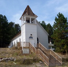 | St. Mark United Presbyterian Church | building | 1980 | 80000899 |
Every wildfire the federal occurrence database records inside this county: 305 of them, burning about 3,322 acres. 33 started naturally and 11 were recorded as arson. Each settlement page carries the fires within five miles of it.
| Reported cause | Fires |
|---|---|
| Missing data/not specified/undetermined | 212 |
| Equipment and vehicle use | 33 |
| Natural | 33 |
| Arson/incendiarism | 11 |
| Debris and open burning | 6 |
| Recreation and ceremony | 5 |
| Fireworks | 2 |
| Railroad operations and maintenance | 1 |
| Smoking | 1 |
| Misuse of fire by a minor | 1 |
The five largest, by the area the report gives. One of them was set deliberately.
| Date | Cause | Size | Reported by | Name on the report |
|---|---|---|---|---|
| 15 September 2015 | Missing data/not specified/undetermined | 610 acres | Elbert County | CR 162 |
| 15 August 2016 | Natural | 580 acres | Agate Volunteer Fire Department | UNKNOWN |
| 4 March 2018 | Missing data/not specified/undetermined | 400 acres | Kiowa Fire Protection District | UNKNOWN |
| 31 August 2011 | Missing data/not specified/undetermined | 350 acres | Colorado State Forest Service-State Headquarters | ELIZABETH |
| 4 February 2017 | Missing data/not specified/undetermined | 300 acres | North Central Fire Protection District | UNKNOWN |
| 21 October 1992 | Recreation and ceremony | 150 acres | El Paso County | not named |
| 11 September 1995 | Natural | 150 acres | Weld County | not named |
| 2 January 2018 | Arson/incendiarism | 100 acres | Kiowa Fire Protection District | UNKNOWN |
Every settlement page carries the fires within five miles of it - see the settlement index below.
The NOAA Storm Events Database holds 805 reports for this county, causing no deaths, 7 injuries and about $921,430 in recorded property damage. Each settlement page carries the reports that name it.
| Kind of event | Reports |
|---|---|
| Hail | 557 |
| Tornado | 127 |
| Thunderstorm Wind | 91 |
| Flash Flood | 22 |
| Lightning | 4 |
| Flood | 3 |
| Heavy Rain | 1 |
The most serious of them, by death, then injury, then recorded damage. The accounts are quoted exactly as the forecast office filed them.
| When | Event | Place named | Harm | What the report says |
|---|---|---|---|---|
| May 2019 | Lightning | Cedar Pt | 4 hurt | Four men were struck by lightning and one was injured while standing near a wrought iron fence at the Riverbend Cemetery. Age of the injured was 39 and the uninjured were 65, with two in their 80s. |
| July 2001 | Lightning | Kiowa | 1 hurt | A 13-yr old boy scout was knocked unconcious when lightning struck a tree near his tent. |
| August 2000 | Thunderstorm Wind | Cedar Pt | 1 hurt | no account filed |
| July 1997 | Thunderstorm Wind | Matheson | 1 hurt | no account filed |
| June 1983 | Tornado (F2) | not stated | $250,000 | no account filed |
| June 2009 | Tornado (EF2) | Elbert | $100,000 | The tornado began 8 miles south-southwest of Elizabeth and produced minor damage to two homes. The tornado then moved southeast and intensified with EF1 and EF2 damage observed 9 miles south of Elizabeth, with substantial damage to a farm, trees, and snapped power poles. The tornado moved on a more southerly track for the next 2 miles with additional EF1 and EF2 damage 11 miles south of Elizabeth. The tornado leveled a 70-yr old barn and a nearby cinder-block shed was torn open. Major tree damage was also observed. The tornado then continued southward for another mile before lifting with some EF0 and EF1 damage 12 miles south of Elizabeth. Minor damage to another home was observed with several large trees uprooted. |
| June 2009 | Tornado (EF0) | Elbert | $75,000 | A small tornado touched down. An airplane hanger was damaged and small plane flipped. |
| July 2009 | Tornado (EF0) | Resolis | $75,000 | Several power poles were completely removed from the ground, knocking out electrical power when a tornado touched down. Some trees and a home were also damaged. |
| June 2009 | Tornado (EF1) | Kiowa | $75,000 | A tornado damaged several outbuildings and a residence, and downed a number of trees. In addition, several horses were injured by flying metal debris. |
| June 2023 | Flash Flood | Matheson | $50,000 | Flash flooding washed out or damaged several county roads north of CO-86 and west of Interstate 70. |
| June 2023 | Flood | Simla | $50,000 | Heavy rain caused flooding and flash flooding which forced the closure of CO-86 at mile marker 44. Storm totals in the area ranged from 3.0 to 4.5 inches. |
| August 2024 | Thunderstorm Wind | Elizabeth | $30,000 | The fire department reported a collapsed outbuilding due to wind damage near intersection of Private Road 160 and County Road 21. |
| June 2010 | Flash Flood | River Bend | $30,000 | Heavy rain caused flash flooding along Interstate 70 at the River Bend Exit. Several cars were reportedly stuck in the floodwaters. |
| May 2015 | Flash Flood | Kiowa | $25,000 | Flooding and flash flooding washed out several county roads including: CR73 from CR112 to CR98; Freese Road from Colorado 86 to CR112; CR102, from Double Tree Ranch to the top of the Bluff; CR9 between Colorado 86 and CR98; CR106, from Canyon Road to CR13; Maul Road also suffered extensive damage. |
| July 2010 | Flash Flood | Elizabeth | $25,000 | Intense thunderstorms, producing heavy rainfall in excess of 5 inches in one hour, produced flash flooding in the vicinity of Elizabeth. Numerous county roads were washed out. The combination of heavy rain and hail made it necessary to run snow plows through the town. Extensive basement flooding was also observed. |
| August 2019 | Flash Flood | Matheson | $15,000 | Flash flooding occurred over southeast Elbert County. Several county roads were either flooded or washed out during the event. |
| June 2015 | Flash Flood | Kiowa | $15,000 | A thunderstorm with very heavy rain, up to 4 inches, produced flash flooding. Elbert County Road 178, between ERC 53 and Wolf Creek Drive was impassable to high water. |
| June 2015 | Flash Flood | Elizabeth | $15,000 | Flash flooding washed out a 6-ft diameter culvert at the end of Glennon Rd., south of Elbert County Road 186. A trained spotter measured 2.22 inches of rainfall in 30 minutes, which produced flash flooding. |
| May 2015 | Flash Flood | Matheson | $15,000 | Heavy rainfall washed out several county roads. |
| June 2015 | Flood | Elizabeth | $15,000 | Heavy rain flooded several rural roads. Basements were also flooded. Flooding was reported along Coal and Running Creeks. Elbert County Road 106 was closed due to high water between Elbert County Roads 5 and 13. |
| July 2014 | Flash Flood | Elizabeth | $10,000 | Over three inches of heavy rain caused flash flooding north and northwest of Elizabeth. The rainfall flooded barns and fields, and inundated the surrounding roadways with standing water. |
| August 2010 | Flash Flood | Kutch | $10,000 | Thunderstorms producing very heavy rain caused flash flooding near Kutch. Several county roads were washed out by the floodwaters. |
| June 2014 | Lightning | Elizabeth | $5,000 | Lightning struck an outbuilding south of Elizabeth, causing moderate damage to the contents inside. Around the same time, lightning struck a satellite dish at a home. |
| July 2011 | Flash Flood | Lowland | $5,000 | A thunderstorm produced very heavy rain, 5 inches in less than 3 hours. Flash flooding made unpaved roads impassable as a fast moving current, about 6 inches deep and a city block wide, inundated County Road 166, west of Ridge Road. In the Chaparrel Subdivision, southwest of Agate, Flooding was also reported along Emerald Trail, Topaz and Amethyst Drives, making those roadways impassable as well. Extensive field flooding was also reported. |
| August 2009 | Thunderstorm Wind | Elbert | $5,000 | Intense thunderstorm winds knocked two power poles down at the intersection of County Roads 33 and 98. |
| August 2008 | Tornado (EF0) | Elizabeth | $5,000 | A landspout tornado touched down briefly. Minor damage was reported which consisted of downed power lines, broken windows and a damaged out building. |
| June 1994 | Thunderstorm Wind | Kiowa | $5,000 | Thunderstorm winds blew two metal sheds 300 yards near Kiowa (40 miles northeast of Colorado Springs). Several power poles were snapped in two. |
| July 2008 | Hail | Kiowa | $5,000 | no account filed |
| August 1993 | Hail | Elbert | $5,000 | no account filed |
| June 1990 | Tornado (F3) | not stated | $2,500 | no account filed |
| June 1980 | Tornado (F1) | not stated | $2,500 | no account filed |
| May 1994 | Thunderstorm Wind | Elizabeth | $500 | Thunderstorm winds gusting to 70 mph (61 knots) blew out windows and damaged a storm door of a home in Elizabeth (28 miles south southeast of Denver). |
| July 1978 | Tornado (F0) | not stated | $250 | no account filed |
| June 1965 | Tornado (F1) | not stated | $250 | no account filed |
| May 1960 | Tornado (F1) | not stated | $250 | no account filed |
| April 1983 | Tornado (F1) | not stated | $30 | no account filed |
| June 1982 | Tornado (F2) | not stated | $30 | no account filed |
| August 1982 | Tornado (F1) | not stated | $30 | no account filed |
| May 1967 | Tornado (F0) | not stated | $30 | no account filed |
| May 1960 | Tornado (F1) | not stated | $30 | no account filed |
| May 1951 | Tornado | not stated | $30 | no account filed |
| August 2025 | Hail | Cedar Pt | - | The report was from mPING. |
| August 2025 | Hail | Matheson | - | The report was from mPING. |
| August 2025 | Hail | Cedar Pt | - | The report was from mPING. |
| August 2025 | Hail | Matheson | - | The report was from mPING. |
| August 2025 | Hail | Cedar Pt | - | The report was from mPING. |
| August 2025 | Hail | Cedar Pt | - | The report was from mPING. |
| August 2025 | Hail | Cedar Pt | - | The hail was measured with digital calipers. |
| August 2025 | Hail | Cedar Pt | - | The report was from mPING. |
| August 2025 | Hail | Cedar Pt | - | The report was from mPING. |
| August 2025 | Hail | Cedar Pt | - | The report was via SpotterNetwork. Radar shows 2 rounds of large hail. |
| August 2025 | Hail | Kiowa | - | The report was from mPING. |
| August 2025 | Hail | Cedar Pt | - | The report was from mPING. |
| August 2025 | Hail | Matheson | - | The report was from mPING. |
| August 2025 | Hail | Matheson | - | The report was from mPING. |
| August 2025 | Hail | Matheson | - | The report was from mPING. |
| August 2025 | Hail | Matheson | - | Off duty NWS employee reported hail up to quarter size. |
| May 2025 | Hail | Elizabeth | - | Report from Mping. |
| May 2025 | Hail | Elbert | - | Report from Mping. |
| May 2025 | Hail | Kiowa | - | Report from Mping. |
The Survey's mineral resources record lists 83 workings inside this county. 65 still produce and 18 are closed or unrecorded. Each settlement page carries the workings within five miles of it.
| Commodity | Workings |
|---|---|
| Sand and Gravel, Construction | 74 |
| Clay | 5 |
| Gold | 3 |
| Silver | 2 |
| Manganese | 1 |
The least common of them first, because a county's hundredth gravel pit says nothing its first ten did not.
| Where | Site | Commodity | Status | Recorded |
|---|---|---|---|---|
| Harris Mn Deposit | Manganese | Past Producer | Psilomelane | |
| Ronk Creek Placer Occurrence | Gold, Silver | Occurrence | Gold | |
| Running Creek Placer Occurrence | Gold, Silver | Occurrence | Gold | |
| Unknown | Gold | Past Producer | ||
| Buffalo | Clay | Producer | ||
| Claypit | Clay | Producer | ||
| Dalrymple | Clay | Producer | ||
| Dawson | Clay | Producer | ||
| Wagner | Clay | Past Producer | ||
| Gravel Pit | Sand and Gravel, Construction | Producer | ||
| Gravel Pit | Sand and Gravel, Construction | Producer | ||
| Gravel Pit | Sand and Gravel, Construction | Producer | ||
| Gravel Pit | Sand and Gravel, Construction | Producer | ||
| Gravel Pit | Sand and Gravel, Construction | Producer | ||
| Gravel Pit | Sand and Gravel, Construction | Producer | ||
| Gravel Pit | Sand and Gravel, Construction | Producer | ||
| Gravel Pit | Sand and Gravel, Construction | Producer | ||
| Gravel Pit | Sand and Gravel, Construction | Producer | ||
| Gravel Pit | Sand and Gravel, Construction | Producer | ||
| Gravel Pit | Sand and Gravel, Construction | Producer | ||
| Gravel Pit | Sand and Gravel, Construction | Producer | ||
| Gravel Pit | Sand and Gravel, Construction | Producer | ||
| Gravel Pit | Sand and Gravel, Construction | Producer | ||
| Gravel Pit | Sand and Gravel, Construction | Producer | ||
| Gravel Pit | Sand and Gravel, Construction | Producer | ||
| Gravel Pit | Sand and Gravel, Construction | Producer | ||
| Gravel Pit | Sand and Gravel, Construction | Producer | ||
| Gravel Pit | Sand and Gravel, Construction | Producer | ||
| Gravel Pit | Sand and Gravel, Construction | Producer | ||
| Gravel Pit | Sand and Gravel, Construction | Producer | ||
| Gravel Pit | Sand and Gravel, Construction | Producer | ||
| Gravel Pit | Sand and Gravel, Construction | Producer | ||
| Gravel Pit | Sand and Gravel, Construction | Producer | ||
| Gravel Pit | Sand and Gravel, Construction | Producer | ||
| Gravel Pit | Sand and Gravel, Construction | Producer | ||
| Gravel Pit | Sand and Gravel, Construction | Producer | ||
| Gravel Pit | Sand and Gravel, Construction | Producer | ||
| Gravel Pit | Sand and Gravel, Construction | Producer | ||
| Gravel Pit | Sand and Gravel, Construction | Producer | ||
| Gravel Pit | Sand and Gravel, Construction | Producer | ||
| Gravel Pit | Sand and Gravel, Construction | Producer | ||
| Gravel Pit | Sand and Gravel, Construction | Producer | ||
| Gravel Pit | Sand and Gravel, Construction | Producer | ||
| Gravel Pit | Sand and Gravel, Construction | Producer | ||
| Gravel Pit | Sand and Gravel, Construction | Producer | ||
| Gravel Pit | Sand and Gravel, Construction | Producer | ||
| Gravel Pit | Sand and Gravel, Construction | Producer | ||
| Gravel Pit | Sand and Gravel, Construction | Producer | ||
| Gravel Pit | Sand and Gravel, Construction | Producer | ||
| Gravel Pit | Sand and Gravel, Construction | Producer | ||
| Gravel Pit | Sand and Gravel, Construction | Producer | ||
| Gravel Pit | Sand and Gravel, Construction | Producer | ||
| Gravel Pit | Sand and Gravel, Construction | Producer | ||
| Gravel Pit | Sand and Gravel, Construction | Producer | ||
| Gravel Pit | Sand and Gravel, Construction | Producer | ||
| Gravel Pit | Sand and Gravel, Construction | Producer | ||
| Gravel Pit | Sand and Gravel, Construction | Producer | ||
| Gravel Pit | Sand and Gravel, Construction | Producer | ||
| Gravel Pit | Sand and Gravel, Construction | Producer | ||
| Gravel Pit | Sand and Gravel, Construction | Producer | ||
| Gravel Pit | Sand and Gravel, Construction | Producer | ||
| Gravel Pit | Sand and Gravel, Construction | Producer | ||
| Gravel Pit | Sand and Gravel, Construction | Producer | ||
| Gravel Pit | Sand and Gravel, Construction | Producer | ||
| Gravel Pit | Sand and Gravel, Construction | Producer | ||
| Gravel Pit | Sand and Gravel, Construction | Producer | ||
| Gravel Pit | Sand and Gravel, Construction | Producer | ||
| Sandpit | Sand and Gravel, Construction | Producer | ||
| Sandpit | Sand and Gravel, Construction | Producer | ||
| Sandpit | Sand and Gravel, Construction | Producer | ||
| Unknown | Sand and Gravel, Construction | Occurrence | Gravel | |
| Unknown | Sand and Gravel, Construction | Occurrence | Gravel | |
| Unknown | Sand and Gravel, Construction | Occurrence | Gravel | |
| Unknown | Sand and Gravel, Construction | Occurrence | Sand and Gravel | |
| Unknown | Sand and Gravel, Construction | Occurrence | Sand and Gravel | |
| Unknown | Sand and Gravel, Construction | Occurrence | Gravel | |
| Unknown | Sand and Gravel, Construction | Occurrence | Sand and Gravel | |
| Unknown | Sand and Gravel, Construction | Occurrence | Sand and Gravel | |
| Unknown | Sand and Gravel, Construction | Occurrence | Sedimentary | |
| Unknown | Sand and Gravel, Construction | Occurrence | Sand and Gravel | |
| Unknown | Sand and Gravel, Construction | Occurrence | Sand and Gravel | |
| Unknown | Sand and Gravel, Construction | Occurrence | Sand and Gravel | |
| Unknown | Sand and Gravel, Construction | Occurrence | Gravel |
Named settlements recorded in the Geographic Names Information System, each with the topographic sheets covering it. Villages, hamlets and abandoned places alike. Each is shown with the nearest named watercourse or landform and the survey quadrangle it falls on.
Elizabeth census division · 80107 · On Gold Creek · Russellville Gulch quadrangle
30 sheets, 1894 to 1983
Elizabeth census division · 80106 · On West Kiowa Creek · Elbert quadrangle
25 sheets, 1894 to 1983
Elizabeth census division · 80138 · Ponderosa Park quadrangle
30 sheets, 1894 to 1983
Elizabeth census division · 80107 · Ponderosa Park quadrangle
30 sheets, 1894 to 1983
Elizabeth census division · 80138 · Ponderosa Park quadrangle
30 sheets, 1894 to 1983