 Block
From the record
3 National Register listings published here.
Sources: the National Register database, National Park Service
46 topographic sheets cover 12 settlements here, and 3 properties are on the National Register of Historic Places.
3 National Register listings published here.
Sources: the National Register database, National Park Service
Every property in this county listed on the National Register of Historic Places, with the year it was listed and the federal nomination document.
| Photograph | Property | Type | Listed | Reference |
|---|---|---|---|---|
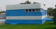 | Hugo Municipal Pool | building | 2008 | 08000692 |
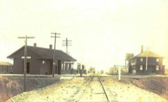 | Limon Railroad Depot | building | 2003 | 03000038 |
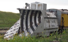 | Rock Island Snow Plow No. 95580 | structure | 2018 | 100002680 |
Every wildfire the federal occurrence database records inside this county: 41 of them, burning about 37,243 acres. 5 started naturally and none was recorded as arson. Each settlement page carries the fires within five miles of it.
| Reported cause | Fires |
|---|---|
| Missing data/not specified/undetermined | 31 |
| Natural | 5 |
| Recreation and ceremony | 3 |
| Equipment and vehicle use | 2 |
The five largest, by the area the report gives. None of them was recorded as arson.
| Date | Cause | Size | Reported by | Name on the report |
|---|---|---|---|---|
| 24 March 2011 | Missing data/not specified/undetermined | 12,000 acres | Pueblo County | KARVAL |
| 31 May 2002 | Natural | 10,000 acres | Pueblo Interagency Dispatch Center | LINCOLN COUNTY COMPLEX |
| 17 April 2018 | Missing data/not specified/undetermined | 7,288 acres | Lincoln County | HWY 94 |
| 17 April 2018 | Missing data/not specified/undetermined | 5,528 acres | Lincoln County | EDISON |
| 18 February 2016 | Missing data/not specified/undetermined | 2,282 acres | Lincoln County | PUMKIN CENTER |
| 27 November 2017 | Missing data/not specified/undetermined | 98 acres | El Paso County | UNKNOWN |
| 6 October 1992 | Natural | 20 acres | El Paso County | not named |
| 11 August 2011 | Missing data/not specified/undetermined | 10 acres | Colorado State Forest Service-State Headquarters | KARVAL |
Every settlement page carries the fires within five miles of it - see the settlement index below.
The NOAA Storm Events Database holds 859 reports for this county, causing no deaths, 19 injuries and about $29,994,710 in recorded property damage. Each settlement page carries the reports that name it.
| Kind of event | Reports |
|---|---|
| Hail | 566 |
| Thunderstorm Wind | 152 |
| Tornado | 115 |
| Flash Flood | 19 |
| Lightning | 3 |
| Heavy Rain | 2 |
| Funnel Cloud | 1 |
| Flood | 1 |
The most serious of them, by death, then injury, then recorded damage. The accounts are quoted exactly as the forecast office filed them.
| When | Event | Place named | Harm | What the report says |
|---|---|---|---|---|
| June 1990 | Tornado (F3) | not stated | 14 hurt, $25,000,000 | no account filed |
| August 2000 | Thunderstorm Wind | (Lic)Limon Arpt | 2 hurt | no account filed |
| June 1951 | Tornado (F2) | not stated | 1 hurt, $25,000 | no account filed |
| May 2001 | Lightning | Limon | 1 hurt | Lightning shocked a woman as she was talking on the phone. She went numb on one side temporarily. |
| June 1988 | Thunderstorm Wind | not stated | 1 hurt | no account filed |
| May 1999 | Tornado (F3) | Genoa | $4,000,000 | no account filed |
| July 2014 | Flash Flood | Karval | $250,000 | Numerous country roads were washed out by heavy rainfall over southern Lincoln County; an estimated 25 roads were damaged or destroyed. The floodwaters washed out several culverts. Some of roads included: Lincoln County Road M, east of CO 71 and LCR K; LCR X just east of LCR 2; LCR J; LCR 17 from LCR M to LCR F. Numerous other county roads were scoured and damaged. Two bridges are heavily scoured on each approach, but the structures remained intact. Doppler radar rainfall estimates and trained spotters indicated that 2 to 4.8 inches of rain had fallen, heaviest in and around Punkin Center. Two residences were reportedly suffered flood damage. |
| May 1991 | Tornado (F1) | not stated | $250,000 | no account filed |
| August 2015 | Tornado (EF1) | Genoa | $100,000 | Another tornado touched down briefly. Two two grain silos were destroyed and nearby power lines. |
| June 2023 | Flash Flood | Genoa | $50,000 | Local law enforcement reported thunderstorms with torrential rain and hail. Storm totals around Limon and Hugo ranged from 2.4 to 3.7 inches. The hail piled up several inches deep along highways 24 and 71, stranding vehicles. Floodwaters up to 2 feet deep were observe running across a roadway 3 miles south of Limon. |
| August 2015 | Tornado (EF1) | Genoa | $50,000 | A tornado touched down briefly. It destroyed an outbuilding and caused minor damage to a nearby home. |
| July 2009 | Flash Flood | Lake | $50,000 | Flash Flooding occurred when torrential rain and hail caused a nearby creek to jump its banks. The creek inundated State Highway 71 with 3 feet of water. Several county roads in the immediate vicinity were also washed out and closed until they could be repaired. |
| July 2013 | Flash Flood | Bagdad | $30,000 | Thunderstorms produced very heavy rain in Lincoln County. Six inches of running water was reported across County Road 2W. The area of water covered approximately 30 to 45 feet of the roadway. In addition, 12 inches of water, approximately 100 to 150 feet in width, was observed running across County Roads 33 and 109. |
| August 2019 | Flash Flood | Limon | $25,000 | Flash flooding occurred in west central Lincoln County. Numerous county roads were either flooded or washed out. State Highway 71 was flooded along Middle Rush Creek. |
| July 2010 | Tornado (EF1) | Karval | $25,000 | A tornado touched down and destroyed a garage and uprooted several trees. |
| July 2009 | Thunderstorm Wind | Boyero | $25,000 | Intense outflow winds associated with a severe thunderstorm damaged a barn. |
| May 1975 | Tornado (F1) | not stated | $25,000 | no account filed |
| May 1965 | Tornado (F2) | not stated | $25,000 | no account filed |
| May 2015 | Flood | Genoa | $15,000 | Heavy rain produced widespread flooding. Several county roads were impassable. |
| June 2010 | Flash Flood | (Lic)Limon Arpt | $10,000 | Heavy rain caused flash flooding over parts of County Road 3J, forcing its closure. |
| June 2023 | Flash Flood | Boyero | $5,000 | Floodwaters of unknown depth caused a single vehicle crash along U.S Highway 287 east of Boyero. |
| July 2008 | Flash Flood | Karval | $5,000 | Flash flooding was reported at the intersection of State Highway 71 and County Road T, where floodwaters up to one foot in depth, covered the roadway. Water was also reportedly flowing across several county roads south of Punkin Center and west of Karval. |
| July 2008 | Flash Flood | Karval | $5,000 | County Road T was washed out and closed approximately 2 miles east of State Highway 71 due to a failed culvert. Flooding of the roadway occurred between Karval and the highway. |
| July 2008 | Flash Flood | Shaw | $5,000 | Heavy rain caused flash flooding near mile marker 213, along State Highway 71. Floodwaters, 2 to 3 feet in depth, covered the highway. |
| September 1993 | Hail | Arriba | $5,000 | no account filed |
| September 1993 | Hail | Limon | $5,000 | no account filed |
| July 1992 | Tornado (F0) | not stated | $2,500 | no account filed |
| June 1992 | Tornado (F0) | not stated | $2,500 | no account filed |
| July 1972 | Tornado (F0) | not stated | $2,500 | no account filed |
| June 1994 | Thunderstorm Wind | Limon | $500 | Thunderstorm winds, estimated at 60 mph (52 knots), blew down fences northeast of Limon. |
| June 1994 | Hail | Genoa | $500 | Tennis ball size hail broke windows and damaged crops north of Genoa (10 miles east of Limon). |
| May 1994 | Thunderstorm Wind | Limon | $500 | A severe thunderstorm rumbled across southwest Lincoln County, dropping hail up to ping pong-ball size and producing wind gusts estimated at 70 mph (61 knots). The hail damaged corn and alfalfa crops. Winds blew the sheet metal off an outbuilding southwest of Limon. |
| September 1993 | Thunderstorm Wind | Arriba | $500 | no account filed |
| April 1983 | Tornado (F1) | not stated | $30 | no account filed |
| June 1983 | Tornado (F1) | not stated | $30 | no account filed |
| June 1982 | Tornado (F1) | not stated | $30 | no account filed |
| July 1982 | Tornado (F1) | not stated | $30 | no account filed |
| July 1982 | Tornado (F1) | not stated | $30 | no account filed |
| June 1982 | Tornado (F1) | not stated | $30 | no account filed |
| October 1956 | Tornado | not stated | $30 | no account filed |
| August 2025 | Hail | Hugo | - | The report was from mPING. |
| August 2025 | Hail | Hugo | - | The report was from mPING. |
| August 2025 | Hail | Hugo | - | The report was from mPING. |
| August 2025 | Hail | Hugo | - | The report was from mPING. |
| August 2025 | Hail | Punkin Center | - | The report was from mPING. |
| August 2025 | Hail | Karval | - | The report was from mPING. |
| August 2025 | Hail | Boyero | - | The report was from mPING. |
| August 2025 | Hail | Karval | - | Several reports of tennis ball sized hail from storm chasers at County Road 109 and County Road W north of Karval. |
| August 2025 | Hail | Limon | - | The report was from mPING. |
| August 2025 | Hail | Limon | - | The report was from mPING. |
| August 2025 | Hail | Hugo | - | The report was from mPING. |
| August 2025 | Hail | Hugo | - | The report was from mPING. |
| August 2025 | Hail | Hugo | - | The report was from mPING. |
| August 2025 | Hail | Punkin Center | - | The report was from mPING. |
| August 2025 | Hail | Punkin Center | - | The report was from mPING. |
| August 2025 | Hail | Karval | - | The report was from mPING. |
| June 2025 | Hail | Genoa | - | Report from mping. |
| June 2025 | Hail | Arriba | - | Report from mping. |
| August 2025 | Thunderstorm Wind | (Lic)Limon Arpt | - | The report was from the ASOS station KLIC (Limon). |
| August 2025 | Hail | Punkin Center | - | The report was from mPING. |
The Survey's mineral resources record lists 75 workings inside this county. None of them still produces: all are closed or unrecorded. Each settlement page carries the workings within five miles of it.
| Commodity | Workings |
|---|---|
| Sand and Gravel, Construction | 74 |
| Stone | 1 |
The least common of them first, because a county's hundredth gravel pit says nothing its first ten did not.
| Where | Site | Commodity | Status | Recorded |
|---|---|---|---|---|
| Lincoln Granite Qy | Stone | Past Producer | ||
| Fisher Pit | Sand and Gravel, Construction | Past Producer | ||
| Unk | Sand and Gravel, Construction | Past Producer | ||
| Unk | Sand and Gravel, Construction | Past Producer | ||
| Unk | Sand and Gravel, Construction | Past Producer | ||
| Unk | Sand and Gravel, Construction | Past Producer | ||
| Unk | Sand and Gravel, Construction | Past Producer | ||
| Unk | Sand and Gravel, Construction | Past Producer | ||
| Unk | Sand and Gravel, Construction | Past Producer | ||
| Unk | Sand and Gravel, Construction | Past Producer | ||
| Unk | Sand and Gravel, Construction | Past Producer | ||
| Unk | Sand and Gravel, Construction | Past Producer | ||
| Unk | Sand and Gravel, Construction | Past Producer | ||
| Unk | Sand and Gravel, Construction | Past Producer | ||
| Unk | Sand and Gravel, Construction | Past Producer | ||
| Unk | Sand and Gravel, Construction | Past Producer | ||
| Unk | Sand and Gravel, Construction | Past Producer | ||
| Unk | Sand and Gravel, Construction | Past Producer | ||
| Unk | Sand and Gravel, Construction | Past Producer | ||
| Unk | Sand and Gravel, Construction | Past Producer | ||
| Unk | Sand and Gravel, Construction | Past Producer | ||
| Unk | Sand and Gravel, Construction | Past Producer | ||
| Unk | Sand and Gravel, Construction | Past Producer | ||
| Unk | Sand and Gravel, Construction | Past Producer | ||
| Unk | Sand and Gravel, Construction | Past Producer | ||
| Unk | Sand and Gravel, Construction | Past Producer | ||
| Unk | Sand and Gravel, Construction | Past Producer | ||
| Unk | Sand and Gravel, Construction | Past Producer | ||
| Unk | Sand and Gravel, Construction | Past Producer | ||
| Unk | Sand and Gravel, Construction | Past Producer | ||
| Unk | Sand and Gravel, Construction | Past Producer | ||
| Unk | Sand and Gravel, Construction | Past Producer | ||
| Unk | Sand and Gravel, Construction | Past Producer | ||
| Unk | Sand and Gravel, Construction | Past Producer | ||
| Unk | Sand and Gravel, Construction | Past Producer | ||
| Unk | Sand and Gravel, Construction | Past Producer | ||
| Unk | Sand and Gravel, Construction | Past Producer | ||
| Unk | Sand and Gravel, Construction | Past Producer | ||
| Unk | Sand and Gravel, Construction | Past Producer | ||
| Unknown | Sand and Gravel, Construction | Occurrence | ||
| Unknown | Sand and Gravel, Construction | Occurrence | ||
| Unknown | Sand and Gravel, Construction | Occurrence | ||
| Unknown | Sand and Gravel, Construction | Occurrence | ||
| Unknown | Sand and Gravel, Construction | Occurrence | ||
| Unknown | Sand and Gravel, Construction | Occurrence | ||
| Unknown | Sand and Gravel, Construction | Occurrence | ||
| Unknown | Sand and Gravel, Construction | Occurrence | ||
| Unknown | Sand and Gravel, Construction | Occurrence | ||
| Unknown | Sand and Gravel, Construction | Occurrence | ||
| Unknown | Sand and Gravel, Construction | Occurrence | ||
| Unknown | Sand and Gravel, Construction | Occurrence | ||
| Unknown | Sand and Gravel, Construction | Occurrence | ||
| Unknown | Sand and Gravel, Construction | Occurrence | ||
| Unknown | Sand and Gravel, Construction | Occurrence | ||
| Unknown | Sand and Gravel, Construction | Occurrence | ||
| Unknown | Sand and Gravel, Construction | Occurrence | ||
| Unknown | Sand and Gravel, Construction | Occurrence | ||
| Unknown | Sand and Gravel, Construction | Occurrence | ||
| Unknown | Sand and Gravel, Construction | Occurrence | ||
| Unknown | Sand and Gravel, Construction | Occurrence | ||
| Unknown | Sand and Gravel, Construction | Occurrence | ||
| Unknown | Sand and Gravel, Construction | Occurrence | ||
| Unknown | Sand and Gravel, Construction | Occurrence | ||
| Unknown | Sand and Gravel, Construction | Occurrence | ||
| Unknown | Sand and Gravel, Construction | Occurrence | ||
| Unknown | Sand and Gravel, Construction | Occurrence | ||
| Unknown | Sand and Gravel, Construction | Occurrence | ||
| Unknown | Sand and Gravel, Construction | Occurrence | ||
| Unknown | Sand and Gravel, Construction | Occurrence | ||
| Unknown | Sand and Gravel, Construction | Occurrence | ||
| Unknown | Sand and Gravel, Construction | Occurrence | ||
| Unknown | Sand and Gravel, Construction | Occurrence | ||
| Unknown | Sand and Gravel, Construction | Occurrence | ||
| Unknown | Sand and Gravel, Construction | Occurrence | ||
| Unknown | Sand and Gravel, Construction | Occurrence |
Named settlements recorded in the Geographic Names Information System, each with the topographic sheets covering it. Villages, hamlets and abandoned places alike. Each is shown with the nearest named watercourse or landform and the survey quadrangle it falls on.
Karval census division · 80823 · McKenzie Draw quadrangle
12 sheets, 1891 to 1984
No longer a settlement
The vanished settlements of Lincoln County: the places named above that are no longer on the map.