 Block
From the record
11 National Register listings published here.
Sources: the National Register database, National Park Service
67 topographic sheets cover 28 settlements here, and 11 properties are on the National Register of Historic Places.
11 National Register listings published here.
Sources: the National Register database, National Park Service
Every property in this county listed on the National Register of Historic Places, with the year it was listed and the federal nomination document.
| Photograph | Property | Type | Listed | Reference |
|---|---|---|---|---|
 | Downtown Sterling Historic District | district | 2013 | 13000592 |
 | First United Presbyterian Church | building | 1982 | 82002304 |
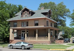 | W. C. Harris House | building | 1984 | 84000864 |
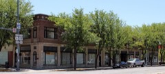 | I and M Building | building | 1982 | 82002305 |
 | Logan County Courthouse | building | 1979 | 79000615 |
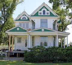 | Conrad Luft Sr. House | building | 1984 | 84000866 |
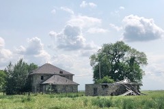 | Powell and Blair Stone Ranch | building | 2004 | 04000261 |
 | St. Anthony's Roman Catholic Church | building | 1982 | 82002306 |
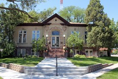 | Sterling Public Library | building | 2001 | 01001121 |
 | Sterling Union Pacific Railroad Depot | building | 1986 | 86000210 |
 | US Post Office, Federal Building, and Federal Courthouse-Sterling Main | building | 1986 | 86000187 |
Every wildfire the federal occurrence database records inside this county: 343 of them, burning about 37,311 acres. 26 started naturally and 7 were recorded as arson. Each settlement page carries the fires within five miles of it.
| Reported cause | Fires |
|---|---|
| Missing data/not specified/undetermined | 212 |
| Equipment and vehicle use | 39 |
| Debris and open burning | 31 |
| Natural | 26 |
| Recreation and ceremony | 11 |
| Smoking | 8 |
| Arson/incendiarism | 7 |
| Fireworks | 4 |
| Railroad operations and maintenance | 3 |
| Misuse of fire by a minor | 1 |
| Power generation/transmission/distribution | 1 |
The five largest, by the area the report gives. None of them was recorded as arson.
| Date | Cause | Size | Reported by | Name on the report |
|---|---|---|---|---|
| 7 March 2017 | Equipment and vehicle use | 30,000 acres | Crook Volunteer Fire Department | LOGAN FIRE |
| 15 July 2006 | Missing data/not specified/undetermined | 3,200 acres | Fort Collins Interagency Dispatch Center | I-76 |
| 27 October 2018 | Missing data/not specified/undetermined | 866 acres | Logan County | EAST LOGAN FIRE |
| 8 July 2020 | Natural | 716 acres | Logan County | COUNTY ROAD 85 |
| 9 March 2017 | Missing data/not specified/undetermined | 682 acres | Logan County | HIGHWAY 61 |
| 11 March 2011 | Missing data/not specified/undetermined | 200 acres | Colorado State Forest Service-State Headquarters | MERINO |
| 18 September 2016 | Equipment and vehicle use | 150 acres | Sterling Fire Rescue | UNKNOWN |
| 20 June 2016 | Equipment and vehicle use | 100 acres | Sterling Fire Rescue | UNKNOWN |
Every settlement page carries the fires within five miles of it - see the settlement index below.
The NOAA Storm Events Database holds 850 reports for this county, causing 2 deaths, 10 injuries and about $21,875,590 in recorded property damage. Each settlement page carries the reports that name it.
| Kind of event | Reports |
|---|---|
| Hail | 522 |
| Thunderstorm Wind | 200 |
| Tornado | 101 |
| Flash Flood | 17 |
| Flood | 5 |
| Funnel Cloud | 2 |
| Lightning | 2 |
| Heavy Rain | 1 |
The most serious of them, by death, then injury, then recorded damage. The accounts are quoted exactly as the forecast office filed them.
| When | Event | Place named | Harm | What the report says |
|---|---|---|---|---|
| June 2009 | Thunderstorm Wind | Marcott | 1 killed, 2 hurt, $75,000 | A wet microburst contributed to a fatal car accident near Holyoke. The combination of very strong winds and heavy rain caused extremely poor visibilities. The severe thunderstorms wind rolled a semi truck hauling an empty trailer on its side. The trailer came to rest on the center median while the truck ended up in the left eastbound lane. A van following behind then struck the undercarriage of the rolled over semi truck and ran off the road. The driver the of the van was killed. His teenage son and the driver of the truck suffered minor injuries. |
| June 2009 | Thunderstorm Wind | Marcott | 1 killed, 2 hurt | no account filed |
| June 2004 | Tornado (F1) | Sterling | 2 hurt, $1,900,000 | A tornado touched down in downtown Sterling, causing extensive damage. At least two commercial buildings, including a car dealership, and one college dormitory lost roofs. Several trees were uprooted; one caused major damage to a home when it fell on it. A semi-truck was also knocked on its side. Downed power lines caused scattered electrical outages which affected about 6,000 customers. A total of 150 buildings received some degree of damage. Four families were left homeless and two residents received minor injuries. Some of the damage to property and structures included: $550,000 for damaged vehicles, $500,000 to the county fairgrounds including the stadium and arena, $200,000 to Sterling High School, $70,000 to Northeastern Junior College, and $20,000 to city property. The total economic impact to Sterling which also involved cleanup and repair was estimated to be between $5 million and $7 million. |
| July 2000 | Tornado (F3) | Dailey | 2 hurt, $750,000 | no account filed |
| June 2011 | Thunderstorm Wind | Merino | 1 hurt | Thunderstorm winds toppled and destroyed a ferris wheel at a carnival ride manufacture facility. In addition, one person received minor injuries when downed electrical lines fell across the vehicle he was sitting in and shocked him. |
| July 2000 | Lightning | Sterling | 1 hurt | A man received minor injuries when lightning struck a nearby fence, shocking him. He was opening a gate attached to the fence when the bolt hit. Lightning also sparked two small grassfires in the area, but the heavy rain that accompanied the storm quickly extinguished them. |
| July 1997 | Flash Flood | Atwood | $12,900,000 | Monsoon moisture continued over the area with thunderstorms drenching the Pawnee National Grasslands, north of Stoneham, with 6 to 8 inches of rainfall. Runoff from the storms eventually turned Pawnee Creek into a huge river. The wall of water, 12 feet high and 200 feet wide made its way downstream flooding the towns of Sterling and Atwood in western Logan County. Highway bridges were washed out, trees uprooted and a portion of Burlington Northern track ripped out. In addition, a 100-ton culvert was torn away and carried downstream approximately 50 feet. In Logan County, 1000 homes and 200 businesses were impacted by the floodwaters as scores of families were evacuated. Some homes in the towns of Sterling and Atwood were under 8 feet of water. At least 13,700 acres of cropland was damaged. Damage estimates of at least $12.9 million were reported to property. A breakdown of the damages included: $10.0 million to homes in Sterling alone, $900,000 to businesses, $1.0 million to a junior college, and at least $1.0 million in damage to state roads, highways and bridges. |
| September 2013 | Flood | Beta | $5,000,000 | The flood crest continued down the South Platte River and caused widespread flooding as it made its way into the communities of Merino, Atwood, Sterling, Illiff, Proctor and Crook. Mandatory evacuations were ordered for those communities threatened by record flooding. The preliminary damage assessment for Logan County indicated 180 residences were affected, with 15 homes completely destroyed. Another 18 homes suffered major damage while 57 had minor damage. There were also 15 mobile homes with minor damage, and 75 accessory structures or private property with minor damage. In addition, 73 miles of asphalt and dirt roads were compromised. All of the main bridges were compromised; eight state bridges and one county bridge. The Northeast Colorado Health Department implemented the closing of several facilities in the city of Sterling due to the damage of Sterling's wastewater system. All retail food, body art, childcare and pool facilities were closed until the system was back up and operating. The headworks facility for the waste water management system was shut down when it became clear the river would swamp the site. |
| June 1988 | Tornado (F2) | not stated | $250,000 | no account filed |
| August 1974 | Tornado (F3) | not stated | $250,000 | no account filed |
| May 2015 | Flood | Peetz | $200,000 | Numerous roads were impassable across western Logan County due to excessive runoff from Pawnee Creek and the South Platte River. Road closures included: CR 113 from the Nebraska line to CO 138; CR 72 from CO 113 to CR 51; CR 51 from CR 72 and CR 74; CR 39 from CR 66 to CR 68; CR 49 from CR 72 to CR 74; CR 20 from CR 9 and CR 11; CR 21 and CR 21.5 at CO 14; and CR 37, one half mile north of CR 52. |
| June 2023 | Flash Flood | Willard | $100,000 | A combination of torrential rain and hail caused flash flooding. Multiple road closures were in effect due to washed out county roads, including County Road 17 south of CO 14. |
| May 2015 | Flood | Sterling Arpt | $100,000 | Heavy rain produced more flooding north of Sterling. Evacuations were ordered for Globe Meadows and areas between Globe Street and Pioneer Road due to ditch flooding west of a trailer park. Many farms in the areas reported flooded basements as well as field and roadway flooding. |
| June 1999 | Tornado (F1) | Crook | $100,000 | no account filed |
| May 2015 | Flash Flood | Padroni | $25,000 | Heavy rain coupled with already swollen rivers and streams produced flash flooding. Numerous county roads were inundated by floodwaters. |
| May 2015 | Flash Flood | Sterling | $25,000 | The small levee breached at the inlet ditch for North Sterling Reservoir. |
| June 1991 | Tornado (F0) | not stated | $25,000 | no account filed |
| May 1988 | Tornado (F1) | not stated | $25,000 | no account filed |
| June 1960 | Tornado (F2) | not stated | $25,000 | no account filed |
| August 2019 | Thunderstorm Wind | Iliff | $20,000 | Intense straight-line winds flipped two pivot sprinklers, uprooted trees and broke several power poles. Corn crops in the area were also extensively damaged. |
| July 2017 | Flash Flood | Atwood | $20,000 | Doppler radar estimated at least 3 inches of rain had fallen southwest of Sterling. |There were numerous reports of low-land flooding in and around Merino. Water flooded, basements, businesses and the post office with around one inch of standing water. |Several rural county roads were damaged by the runoff from flooded fields. |
| August 2009 | Hail | Dailey | $15,000 | Several windows were broken and some poultry killed. |
| June 2024 | Flash Flood | Sterling | $10,000 | Reports of flooded roads with water 2 to 3 feet deep in some areas. Hail clogged the city's storm drains. The basements of the Logan County Courthouse and the courthouse annex flooded. |
| August 2014 | Flash Flood | Fleming | $10,000 | Heavy rain produced flash flooding across Logan County Road 81, where up to a foot of water was observed running across the road. Some field flooding was also reported. |
| July 2010 | Thunderstorm Wind | Iliff | $10,000 | Damaging thunderstorm winds snapped tree branches, 6 inches in diameter and larger. In addition, a roof to a structure under construction was damaged in Iliff and the material tossed. |
| August 2009 | Flash Flood | Crook | $10,000 | Major flooding was observed in Crook. Anywhere from 1 to 3 feet of standing water was reported in parts of town. |
| May 2000 | Tornado (F1) | Fleming | $10,000 | A small tornado touched down, damaging some weather equipment and several nearby structures. |
| July 2008 | Flash Flood | Fleming | $5,000 | Heavy rain damaged corn crops and washed out several county roads. |
| August 2009 | Hail | Crook | $3,000 | no account filed |
| July 1998 | Hail | Sterling | $2,500 | no account filed |
| July 1989 | Tornado (F1) | not stated | $2,500 | no account filed |
| June 1983 | Tornado (F1) | not stated | $2,500 | no account filed |
| August 1982 | Tornado (F1) | not stated | $2,500 | no account filed |
| July 1958 | Tornado (F1) | not stated | $2,500 | no account filed |
| June 1982 | Tornado (F1) | not stated | $30 | no account filed |
| June 1982 | Tornado (F1) | not stated | $30 | no account filed |
| May 1958 | Tornado | not stated | $30 | no account filed |
| August 2025 | Hail | Sterling | - | Delayed report via CoCoRaHS observer. |
| June 2025 | Hail | Sterling | - | Report from mping. |
| June 2025 | Thunderstorm Wind | Sterling | - | Mesonet station (CDOT) on I-76 Sterling. |
| May 2025 | Hail | Willard | - | Report from Mping. |
| May 2025 | Hail | Willard | - | Report from Mping. |
| May 2025 | Hail | Merino | - | Report from Mping. |
| May 2025 | Hail | Atwood | - | Report from Mping. |
| May 2025 | Hail | Atwood | - | Report from Mping. |
| May 2025 | Hail | Atwood | - | Report from Mping. |
| May 2025 | Tornado (EF1) | Willard | - | The formation of this tornado was captured well by storm chaser video. The tornado did not have a coherent damage path. There was sporadic damage south of the South Platte River, primarily to a trio of grain silos. Two silos had their tops removed, one was shifted off the pad, another was destroyed. One off duty NWS employee confirmed the location of the tornado as it crossed Logan County Road R just south of County Road 59. The tornado dissipated just southwest of the Prewitt Reservoir with no evidence it crossed I-76. |
| May 2025 | Thunderstorm Wind | Iliff | - | Power line down by County Road 55 north of Iliff. Spotter also reported no power in town. Location and time estimated. |
| May 2025 | Hail | Willard | - | Report from Mping. |
| May 2025 | Thunderstorm Wind | Sterling Arpt | - | Awos station STK Sterling. |
| August 2025 | Thunderstorm Wind | Sterling | - | The report was received from mesonet station CO035 I-76 near Sterling. The peak gust of 58 knots was reported at 1904, but the first reported gust of 50 knots was at 1854. |
| May 2025 | Thunderstorm Wind | Willard | - | At the station 1MW which is 15 miles west-northwest of Sterling. |
| May 2025 | Hail | Iliff | - | Half inch to one inch hail covering the ground. |
| May 2025 | Thunderstorm Wind | Peetz | - | Awos station near Peetz. |
| May 2025 | Thunderstorm Wind | Iliff | - | Spotter confident in at least 80 mph wind gusts. Damage to branches 7 to 8 inches in diameter reported, as well as an overturned pivot sprinkler. |
| May 2025 | Hail | Willard | - | Report from Mping. |
| May 2025 | Thunderstorm Wind | Iliff | - | CoAgMet Station near Iliff. |
| July 2025 | Hail | Dailey | - | Accumulating hail. Storm chaser reports of several inches of hail accumulated on the roads southwest of Haxtun. Larger stones were just under quarter size 30 minutes after the large hail fell. Time estimated by radar. |
| August 2025 | Thunderstorm Wind | Padroni | - | The report was from mesonet station TT562 North Sterling. |
| August 2025 | Thunderstorm Wind | Peetz | - | The report was from AWOS station K1JW near Peetz. |
The Survey's mineral resources record lists 106 workings inside this county. 1 still produces and 105 are closed or unrecorded. Each settlement page carries the workings within five miles of it.
| Commodity | Workings |
|---|---|
| Sand and Gravel, Construction | 102 |
| Fire Clay (Refractory) | 2 |
| Uranium | 1 |
| Copper | 1 |
The least common of them first, because a county's hundredth gravel pit says nothing its first ten did not.
| Where | Site | Commodity | Status | Recorded |
|---|---|---|---|---|
| Tom Hoosier | Copper | Unknown | ||
| Unnamed Uranium Occurrence | Uranium | Occurrence | 1943 | |
| Unknown | Fire Clay (Refractory) | Occurrence | ||
| Unknown | Fire Clay (Refractory) | Occurrence | ||
| Northeastern | Sand and Gravel, Construction | Unknown | ||
| Pre-Ten | Sand and Gravel, Construction | Unknown | ||
| Sterling Ready Mix | Sand and Gravel, Construction | Producer | ||
| Unk | Sand and Gravel, Construction | Unknown | ||
| Unk | Sand and Gravel, Construction | Unknown | ||
| Unk | Sand and Gravel, Construction | Unknown | ||
| Unk | Sand and Gravel, Construction | Unknown | ||
| Unk | Sand and Gravel, Construction | Unknown | ||
| Unk | Sand and Gravel, Construction | Unknown | ||
| Unk | Sand and Gravel, Construction | Unknown | ||
| Unk | Sand and Gravel, Construction | Unknown | ||
| Unk | Sand and Gravel, Construction | Unknown | ||
| Unk | Sand and Gravel, Construction | Unknown | ||
| Unk | Sand and Gravel, Construction | Unknown | ||
| Unk | Sand and Gravel, Construction | Unknown | ||
| Unk | Sand and Gravel, Construction | Unknown | ||
| Unk | Sand and Gravel, Construction | Unknown | ||
| Unk | Sand and Gravel, Construction | Unknown | ||
| Unk | Sand and Gravel, Construction | Unknown | ||
| Unk | Sand and Gravel, Construction | Unknown | ||
| Unk | Sand and Gravel, Construction | Unknown | ||
| Unk | Sand and Gravel, Construction | Unknown | ||
| Unk | Sand and Gravel, Construction | Unknown | ||
| Unk | Sand and Gravel, Construction | Unknown | ||
| Unk | Sand and Gravel, Construction | Unknown | ||
| Unk | Sand and Gravel, Construction | Unknown | ||
| Unk | Sand and Gravel, Construction | Unknown | ||
| Unk | Sand and Gravel, Construction | Unknown | ||
| Unk | Sand and Gravel, Construction | Unknown | ||
| Unk | Sand and Gravel, Construction | Unknown | ||
| Unk | Sand and Gravel, Construction | Unknown | ||
| Unk | Sand and Gravel, Construction | Unknown | ||
| Unk | Sand and Gravel, Construction | Unknown | ||
| Unk | Sand and Gravel, Construction | Unknown | ||
| Unk | Sand and Gravel, Construction | Unknown | ||
| Unk | Sand and Gravel, Construction | Unknown | ||
| Unk | Sand and Gravel, Construction | Unknown | ||
| Unk | Sand and Gravel, Construction | Unknown | ||
| Unk | Sand and Gravel, Construction | Unknown | ||
| Unk | Sand and Gravel, Construction | Unknown | ||
| Unk | Sand and Gravel, Construction | Unknown | ||
| Unk | Sand and Gravel, Construction | Unknown | ||
| Unk | Sand and Gravel, Construction | Unknown | ||
| Unk | Sand and Gravel, Construction | Unknown | ||
| Unk | Sand and Gravel, Construction | Unknown | ||
| Unk | Sand and Gravel, Construction | Unknown | ||
| Unk | Sand and Gravel, Construction | Unknown | ||
| Unk | Sand and Gravel, Construction | Unknown | ||
| Unk | Sand and Gravel, Construction | Unknown | ||
| Unk | Sand and Gravel, Construction | Unknown | ||
| Unk | Sand and Gravel, Construction | Unknown | ||
| Unk | Sand and Gravel, Construction | Unknown | ||
| Unk | Sand and Gravel, Construction | Unknown | ||
| Unk | Sand and Gravel, Construction | Unknown | ||
| Unk | Sand and Gravel, Construction | Unknown | ||
| Unk | Sand and Gravel, Construction | Unknown | ||
| Unk | Sand and Gravel, Construction | Unknown | ||
| Unk | Sand and Gravel, Construction | Unknown | ||
| Unk | Sand and Gravel, Construction | Unknown | ||
| Unk | Sand and Gravel, Construction | Unknown | ||
| Unk | Sand and Gravel, Construction | Unknown | ||
| Unk | Sand and Gravel, Construction | Unknown | ||
| Unk | Sand and Gravel, Construction | Unknown | ||
| Unknown | Sand and Gravel, Construction | Occurrence | Sand | |
| Unknown | Sand and Gravel, Construction | Occurrence | Gravel | |
| Unknown | Sand and Gravel, Construction | Occurrence | Gravel | |
| Unknown | Sand and Gravel, Construction | Occurrence | Gravel | |
| Unknown | Sand and Gravel, Construction | Occurrence | Gravel | |
| Unknown | Sand and Gravel, Construction | Occurrence | Gravel | |
| Unknown | Sand and Gravel, Construction | Occurrence | Gravel | |
| Unknown | Sand and Gravel, Construction | Occurrence | Gravel | |
| Unknown | Sand and Gravel, Construction | Occurrence | Gravel | |
| Unknown | Sand and Gravel, Construction | Occurrence | Gravel | |
| Unknown | Sand and Gravel, Construction | Occurrence | Gravel | |
| Unknown | Sand and Gravel, Construction | Occurrence | Gravel | |
| Unknown | Sand and Gravel, Construction | Occurrence | Gravel | |
| Unknown | Sand and Gravel, Construction | Occurrence | Gravel | |
| Unknown | Sand and Gravel, Construction | Occurrence | Gravel | |
| Unknown | Sand and Gravel, Construction | Occurrence | Gravel | |
| Unknown | Sand and Gravel, Construction | Occurrence | Gravel | |
| Unknown | Sand and Gravel, Construction | Occurrence | Gravel | |
| Unknown | Sand and Gravel, Construction | Occurrence | Gravel | |
| Unknown | Sand and Gravel, Construction | Occurrence | Gravel | |
| Unknown | Sand and Gravel, Construction | Occurrence | Gravel | |
| Unknown | Sand and Gravel, Construction | Occurrence | Gravel | |
| Unknown | Sand and Gravel, Construction | Occurrence | Gravel | |
| Unknown | Sand and Gravel, Construction | Occurrence | Gravel | |
| Unknown | Sand and Gravel, Construction | Occurrence | Gravel | |
| Unknown | Sand and Gravel, Construction | Occurrence | Gravel | |
| Unknown | Sand and Gravel, Construction | Occurrence | Gravel | |
| Unknown | Sand and Gravel, Construction | Occurrence | Gravel | |
| Unknown | Sand and Gravel, Construction | Occurrence | Gravel | |
| Unknown | Sand and Gravel, Construction | Occurrence | Gravel | |
| Unknown | Sand and Gravel, Construction | Occurrence | Gravel | |
| Unknown | Sand and Gravel, Construction | Occurrence | Gravel | |
| Unknown | Sand and Gravel, Construction | Occurrence | Gravel | |
| Unknown | Sand and Gravel, Construction | Occurrence | Gravel | |
| Unknown | Sand and Gravel, Construction | Occurrence | Gravel | |
| Unknown | Sand and Gravel, Construction | Occurrence | Gravel | |
| Unknown | Sand and Gravel, Construction | Occurrence | Gravel | |
| Unknown | Sand and Gravel, Construction | Occurrence | Gravel | |
| Van Gundy Pit | Sand and Gravel, Construction | Unknown |
Named settlements recorded in the Geographic Names Information System, each with the topographic sheets covering it. Villages, hamlets and abandoned places alike. Each is shown with the nearest named watercourse or landform and the survey quadrangle it falls on.
Sterling census division · 80751 · On Cedar Creek · Sterling North quadrangle
9 sheets, 1951 to 1983
Merino census division · 80751 · Near Pawnee Valley · Atwood quadrangle
9 sheets, 1951 to 1983
Crook census division · 80736 · Near Skinner Draw · Proctor quadrangle
10 sheets, 1953 to 1983
Fleming census division · 80728 · Saint Petersburg quadrangle
6 sheets, 1954 to 1983
Sterling census division · 80745 · Near Spring Draw · Westplains quadrangle
6 sheets, 1954 to 1983