 Block
From the record
15 National Register listings published here.
Sources: the National Register database, National Park Service
77 topographic sheets cover 24 settlements here, and 15 properties are on the National Register of Historic Places.
15 National Register listings published here.
Sources: the National Register database, National Park Service
Every property in this county listed on the National Register of Historic Places, with the year it was listed and the federal nomination document.
| Photograph | Property | Type | Listed | Reference |
|---|---|---|---|---|
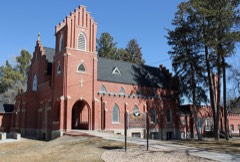 | All Saints Church of Eben Ezer | building | 1982 | 82002310 |
| Central Platoon School | building | 2001 | 01001194 | |
 | Farmers State Bank Building | building | 1990 | 90001422 |
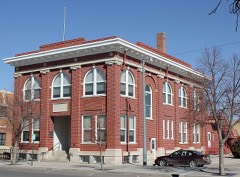 | Fort Morgan City Hall | building | 1995 | 95001339 |
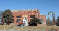 | Fort Morgan Power Plant Building | structure | 1994 | 93001553 |
 | Fort Morgan State Armory | building | 2004 | 04000596 |
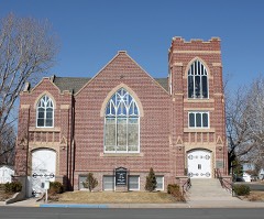 | German Evangelical Immanuel Congregational Church | building | 2005 | 05001161 |
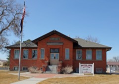 | Knearl School | building | 1997 | 97000017 |
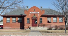 | Lincoln School | building | 2010 | 10000216 |
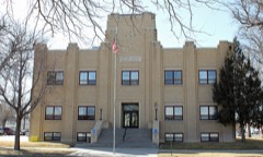 | Morgan County Courthouse and Jail | building | 2002 | 02000289 |
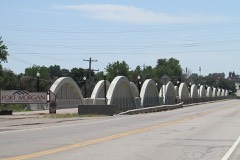 | Rainbow Arch Bridge | structure | 1985 | 85000221 |
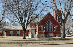 | Rankin Presbyterian Church | building | 2007 | 07000696 |
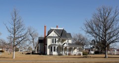 | Sherman Street Historic Residential District | district | 1987 | 87001286 |
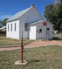 | Trail School, Old | building | 2004 | 04000337 |
 | US Post Office-Fort Morgan Main | building | 1986 | 86000177 |
Every wildfire the federal occurrence database records inside this county: 280 of them, burning about 2,528 acres. 11 started naturally and none was recorded as arson. Each settlement page carries the fires within five miles of it.
| Reported cause | Fires |
|---|---|
| Missing data/not specified/undetermined | 196 |
| Equipment and vehicle use | 58 |
| Natural | 11 |
| Fireworks | 3 |
| Recreation and ceremony | 3 |
| Railroad operations and maintenance | 3 |
| Smoking | 3 |
| Debris and open burning | 2 |
| Power generation/transmission/distribution | 1 |
The five largest, by the area the report gives. None of them was recorded as arson.
| Date | Cause | Size | Reported by | Name on the report |
|---|---|---|---|---|
| 31 August 2004 | Natural | 1,000 acres | Fort Collins Interagency Dispatch Center | SAGE BRUSH |
| 7 July 2020 | Missing data/not specified/undetermined | 395 acres | Morgan County | IA 387 |
| 10 May 2018 | Missing data/not specified/undetermined | 380 acres | Morgan County | TEAGUE RANCH |
| 10 April 2020 | Debris and open burning | 150 acres | Fort Morgan Fire Department | N/A |
| 5 August 2020 | Natural | 100 acres | Morgan County | COUNTY ROAD F |
| 27 June 2018 | Natural | 100 acres | Fort Morgan Fire Department | UNKNOWN |
| 17 April 2011 | Missing data/not specified/undetermined | 100 acres | Colorado State Forest Service-State Headquarters | FORT MORGAN |
| 6 March 2017 | Equipment and vehicle use | 60 acres | Fort Morgan Fire Department | UNKNOWN |
Every settlement page carries the fires within five miles of it - see the settlement index below.
The NOAA Storm Events Database holds 805 reports for this county, causing no deaths, 13 injuries and about $38,523,170 in recorded property damage. Each settlement page carries the reports that name it.
| Kind of event | Reports |
|---|---|
| Hail | 478 |
| Thunderstorm Wind | 178 |
| Tornado | 95 |
| Flash Flood | 32 |
| Lightning | 10 |
| Flood | 7 |
| Heavy Rain | 3 |
| Funnel Cloud | 2 |
The most serious of them, by death, then injury, then recorded damage. The accounts are quoted exactly as the forecast office filed them.
| When | Event | Place named | Harm | What the report says |
|---|---|---|---|---|
| July 1999 | Thunderstorm Wind | Ft Morgan | 10 hurt | Intense straight-line winds associated with a wet microburst blew 6 vehicles off Interstate 76, including a pickup pulling a horse trailer. Several windows were blown out of homes and vehicles in the Fort Morgan and Brush areas. As a result, 10 people were treated at area hospitals for cuts and bruises. In addition to the damage to property, numerous crops were reportedly flattened by the combination of heavy rain, hail and damaging winds. |
| May 1998 | Hail | Brush | 2 hurt, $2,200,000 | Large hail pummelled the towns of Greeley, Brush and Fort Morgan. In Brush, some roofs collapsed under the deluge and one roof was blown off. Two people received minor injuries. One woman was injured, while in her home, when large hail broke through the window. Hundreds of cars were also damaged and some were stuck in the hail, up to 18 inches deep, until snowplows could clear the roads off. Crops were shredded during the hailstorm and fields flooded. Approximately 140,000 acres of cropland in and around Brush were devastated. Damage estimates to homes and vehicle in the Greeley, Brush and Fort Morgan areas was estimated at $2.2 million. In addition, crop losses from the storm were expected to exceed $1.0 million. |
| May 2008 | Thunderstorm Wind | Lodi | 1 hurt | Thunderstorm winds knocked down a carport and injured one person. |
| September 2013 | Flood | Orchard | $30,700,000 | The preliminary damage assessment included: $1,510,800 for Residential Property Damage; $4,560,000 for County Bridge Infrastructure: $3,350,000 for County Asphault Infrastructure; and $786,000 for Gravel Road Infrastructure. Most of the damage to the city was sustained in Riverside Park. The city estimated a total cost of the flood at $20 million, including damages and expenditures. Agricultural producers in Morgan County saw little damage from the flood overall. |
| July 1997 | Flash Flood | Weldona | $2,000,000 | Radar estimates of 5 to 6 inches of rainfall were observed over northern portions of Morgan County during the evening hours. The brunt of the flooding occurred between 10 pm and 12 am lst when the Weldona Valley Ditch broke. The ensuing floodwaters, up to 4 feet deep, inundated the entire town. Approximately 50 families had to be evacuated, many from their rooftops. Although no dollar estimate was available, 48 homes were damaged, 13 extensively, as well as at least 30 vehicles. Several homes had to be condemned. In addition, $2.0 million in damage was reported to roads, businesses and public buildings in town. |
| May 2023 | Tornado (EF1) | Gary | $500,000 | A tornado touched down east of Woodrow and tracked north-northeast across Morgan County. The tornado struck a sturdy residence; it uplifted and removed the roof from the home which exposed portions of the second floor. The tornado also damaged the roof of a nearby barn, destroyed to small storage sheds and uprooted some trees on the property. |
| May 2015 | Flood | Goodrich | $500,000 | The combination of saturating rains in the first part of May, and the May 8th and 9th heavy rain storms, produced more water than the creeks and drainages could handle. Flooding due to rain water started to move east through the county washing over county roads, both dirt and pavement).The southwest and northeast portions of the county were greatly affected and the majority of roads in these areas we impassable by vehicle due to water either running over the roads or water cutting trenches through the road. County roads throughout Morgan County were inundated by floodwaters. Some parts of the county received at least 10 inches of rainfall over a two week period. |
| June 1994 | Thunderstorm Wind | Fort Morgan | $500,000 | Thunderstorm winds caused major damage to several farms north of Fort Morgan. The winds destroyed five grain bins, and damaged several buildings, including two homes. The winds also toppled a semi-trailer on Interstate 76 near Fort Morgan. |
| June 1990 | Tornado (F2) | not stated | $250,000 | no account filed |
| September 1986 | Tornado (F2) | not stated | $250,000 | no account filed |
| May 1984 | Tornado (F2) | not stated | $250,000 | no account filed |
| June 2015 | Flood | Balzac | $150,000 | A levee breach along the South Platte River produced farmland flooding over northeast Morgan County. Morgan County Road 7 was also washed out. |
| May 1996 | Tornado (F2) | Ft Morgan | $150,000 | no account filed |
| July 2016 | Flash Flood | Ft Morgan | $100,000 | Heavy rain, an estimated 2 to 4 inches in 30 minutes, produced extensive flooding of streets, businesses and basements in town. |
| June 2009 | Thunderstorm Wind | Wiggins | $100,000 | Intense thunderstorm winds destroyed an outbuilding and a pivot sprinkler on a farm. A semi-trailer traveling along Interstate 76 was also blown on its side. The driver was uninjured although the damage to his truck was extensive. |
| July 2009 | Flash Flood | Bijou | $100,000 | A wet microburst produced damaging wind and very heavy rain in the Fort Morgan area. Flash flooding occurred in Fort Morgan when up to 2 inches of rain reportedly fell in less than 20 minutes. Some parts of the city were inundated with 2.5 feet of standing water. Along County Road 20, up to 3 feet of water covered parts of the roadway. Minor flooding was also reported in Log Lane Village. |
| June 1997 | Thunderstorm Wind | Ft Morgan | $100,000 | Powerful thunderstorm winds lifted two barns from their foundations and levelled them. In addition, two grain bins were damaged, power poles and lines were downed causing scattered outages around the area. Several automobiles and other structures were damaged by falling trees. Heavy rain associated with the storms also caused localized flooding problems. Approximately 30,000 acres of crops in Morgan County were damaged. Corn crops experienced a 10 percent loss, beet and alfalfa crops incurred a 5 percent loss. |
| August 2010 | Tornado (EF1) | Brush | $50,000 | A tornado touched down near a home. It uprooted trees and did some damage to the home, breaking windows some windows. Two horse trailers were picked up and thrown approximately 100 yards. Several hundred yards of fence were torn out of the ground, and several wood and steel fence posts were torn out of the ground. Debris was found up to a mile from where the tornado touched down. A small horse barn that had been recently built was also destroyed; one horse was badly injured and was later euthanized. |
| August 2010 | Flash Flood | Ft Morgan | $50,000 | Heavy rain produced flash flooding in and around Fort Morgan. Widespread flooding was reported to homes and businesses. Basements were flooded as the streets were inundated with 1 to 3 feet of standing water. Radar estimated up to 3 inches of rain had fallen in the area. |
| June 2009 | Flash Flood | Ft Morgan Arpt | $50,000 | Heavy rain from numerous thunderstorms produced extensive flooding of roads and ditches along the Wildcat Creek area. One resident measured 5 1/2 inches of rainfall with the storms. Law enforcement reported State Highway 52 and County Road AA were under several feet of water. Several other county roads were damaged by heavy rain with extensive field flooding reported. One accident occurred when a driver drove his truck into the washed out portion of County Road Y just east of State Highway 52. He escaped the submerged truck uninjured. |
| July 2009 | Thunderstorm Wind | Brush | $50,000 | Damaging thunderstorm winds toppled two grain elevators and knocked a tree into a home. In addition, some empty trailers were blown onto their sides. Some outbuildings at High Plains Livestock suffered roof damage and broken windows. The combination of strong wind and marble size hail also caused extensive crop damage. |
| July 2000 | Flash Flood | East Central Portion | $50,000 | Very heavy rain, large hail and extensive flash flooding accompanied a line of nearly stationary thunderstorms that formed across eastern and southern portions of Morgan County. Radar estimated at least 6 inches of rain fell during the late afternoon. The heaviest concentration of rain fell in an area bounded by the following locations: Snyder, Brush, 9-mile Corner and Fort Morgan. Beaver Creek, south of Brush, jumped its banks and forced the closure of State Highway 71. Several smaller county roads were washed out and closed due to floodwaters east and south of Brush. In Fort Morgan, numerous cars were stranded and basements flooded, as much of the town was under at least a foot of water. In Morgan County, flood damage to private land was approximately $200,000, with another $50,000 damage to public infrastructures, including a small dam that was breached. |
| June 1997 | Tornado (F1) | Brush | $35,000 | A small tornado damaged an irrigation sprinkler and tore up several bales of hay. The irrigation sprinkler was picked up 3 to 4 feet into the air and flipped. |
| August 2024 | Flash Flood | Brush | $25,000 | Widespread Flash Flooding in reported in Brush due to 4 inches of rain. Exact location was estimated. No reports of damage, but there was likely some. |
| May 2015 | Flash Flood | Brush | $25,000 | Several roads in the Brush area were inundated by floodwaters. |
| May 2015 | Flash Flood | Hoyt | $25,000 | Numerous roads in southwest Morgan County were inundated by floodwaters. |
| May 2015 | Flash Flood | Brush | $25,000 | Heavy rain continued to produce flooding and flash flooding, inundating numerous roads across east central Morgan County. |
| August 2014 | Flood | Hoyt | $25,000 | Heavy rain on top of already saturated soils produced extensive small stream flooding southwest of Fort Morgan. |
| June 2010 | Flash Flood | Ft Morgan | $25,000 | Heavy rain triggered flash flooding in the Fort Morgan and Brush areas. Numerous streets were closed due to the high floodwaters. Flooding was also reported on County Road T, near State Highway 52. A trained spotter in Fort Morgan measured 3 inches of rainfall. |
| June 2010 | Flash Flood | Vallery | $25,000 | Severe thunderstorms with large hail and heavy rain produced widespread street flooding in the Fort Morgan and Brush areas. Several street closures were reported. Floodwaters were observed across State Highway 71 and Highway R, between County Roads 26 and 27. Extensive field flooding was also reported around Weldona. |
| July 1985 | Tornado (F1) | not stated | $25,000 | no account filed |
| June 1984 | Tornado (F1) | not stated | $25,000 | no account filed |
| May 1984 | Tornado (F1) | not stated | $25,000 | no account filed |
| June 1981 | Tornado (F1) | not stated | $25,000 | no account filed |
| July 2022 | Flash Flood | Weldona | $15,000 | Heavy rain from 1.9 to 3.50 inches was observed near Brush. Flooding was reported along County Road U, just west of Highway 71. A basement in the area also flooded. County Road 28, north of Brush, was completely washed out and underwater. |
| August 2000 | Lightning | Ft Morgan | $15,000 | Lightning damaged a power plant near Fort Morgan. |
| June 2014 | Flash Flood | Goodrich | $10,000 | A wet microburst produced a flash flood. Up to 8 inches of water was observed running across Morgan County Road BB, about one half mile west of Colorado State Highway 52. Flooding along Wildcat Creek inundated nearby low lying areas. |
| June 2010 | Flash Flood | Snyder | $10,000 | Several county roads were flooded. |
| August 2008 | Flash Flood | Orchard | $10,000 | Heavy rain washed out numerous county roads from Orchard to Wiggins. Other roadways in the area were under water as up to 3 inches of rain reportedly fell. |
| July 2008 | Flash Flood | Brush | $10,000 | Floodwaters, up to one foot in depth, caused extensive flooding in Brush. Streets and yards were flooded, and the high water entered several homes. |
| July 2000 | Thunderstorm Wind | Brush | $10,000 | Microburst winds damaged a garage and destroyed a small shed in Brush. The burst blew the roof off the garage and smashed the shed. |
| August 2017 | Flash Flood | Ft Morgan | $5,000 | Law enforcement closed two roadways due to high water. |
| August 2009 | Lightning | Ft Morgan | $5,000 | Lightning ignited an oil tank approximately 12-ft in diameter and 25-ft high. |
| June 2008 | Flash Flood | Bijou | $5,000 | County officials reported 12 to 24 inches of water across numerous roads including State Highway 71, south of Brush. Many farm fields were completely covered in water as Little Beaver Creek and irrigation ditches overflowed their banks. |
| June 2008 | Flash Flood | Ft Morgan Arpt | $5,000 | Numerous roadways were reportedly flooded from Fort Morgan to Brush. Little Beaver Creek continued to run out of its banks, completely inundating the surrounding farm fields. |
| July 2013 | Thunderstorm Wind | Lodi | $3,000 | Part of a roof was blown off a building. |
| September 1984 | Tornado (F1) | not stated | $2,500 | no account filed |
| July 1955 | Tornado (F2) | not stated | $2,500 | no account filed |
| June 2011 | Lightning | Ft Morgan | $2,000 | Lightning struck the top of the bell tower at a church in town causing minor damage. |
| June 2008 | Flash Flood | Vallery | $1,000 | A spotter reported flooding at the intersections of County Roads 14 and P, as over 5 inches of rain reportedly fell. |
| July 2007 | Flash Flood | Ft Morgan | $1,000 | no account filed |
| May 1994 | Thunderstorm Wind | Fort Morgan | $500 | A severe thunderstorm rumbled across portions of Weld and Morgan Counties. Spotters reported golf-ball size hail fell east of Kersey (37 miles east southeast of Fort Collins). Thunderstorm winds knocked down numerous trees and toppled power poles in Fort Morgan and near Jackson Reservoir (18 miles northwest of Fort Morgan). |
| June 1979 | Tornado (F1) | not stated | $250 | no account filed |
| June 1956 | Tornado (F2) | not stated | $250 | no account filed |
| June 1983 | Tornado (F1) | not stated | $30 | no account filed |
| August 1982 | Tornado (F1) | not stated | $30 | no account filed |
| June 1979 | Tornado (F0) | not stated | $30 | no account filed |
| May 1962 | Tornado (F0) | not stated | $30 | no account filed |
| May 1962 | Tornado (F0) | not stated | $30 | no account filed |
| August 1994 | Thunderstorm Wind | Brush | $20 | Thunderstorm winds caused several 4-5 inch diameter trees to blow over. A motor boat was tossed off a trailer. |
The Survey's mineral resources record lists 34 workings inside this county. 19 still produce and 15 are closed or unrecorded. Each settlement page carries the workings within five miles of it.
| Commodity | Workings |
|---|---|
| Sand and Gravel, Construction | 21 |
| Clay | 10 |
| Fire Clay (Refractory) | 2 |
| Calcium | 1 |
The least common of them first, because a county's hundredth gravel pit says nothing its first ten did not.
| Where | Site | Commodity | Status | Recorded |
|---|---|---|---|---|
| Fort Morgan Plant | Calcium | Producer | ||
| Unknown | Fire Clay (Refractory) | Occurrence | Sedimentary | |
| Unknown | Fire Clay (Refractory) | Occurrence | Sedimentary | |
| Borrow Pit | Clay | Producer | ||
| Clay Pit | Clay | Producer | ||
| Clay Pit | Clay | Producer | ||
| Clay Pit | Clay | Producer | ||
| Clay Pit | Clay | Producer | ||
| Clay Pit | Clay | Producer | ||
| Unknown | Clay | Occurrence | Sedimentary | |
| Unknown | Clay | Occurrence | Sedimentary | |
| Unknown | Clay | Occurrence | ||
| Unknown | Clay | Occurrence | Sedimentary | |
| Gravel Pit | Sand and Gravel, Construction | Producer | ||
| Gravel Pit | Sand and Gravel, Construction | Producer | ||
| Gravel Pit | Sand and Gravel, Construction | Producer | ||
| Gravel Pit | Sand and Gravel, Construction | Producer | ||
| Gravel Pit | Sand and Gravel, Construction | Producer | ||
| Gravel Pit | Sand and Gravel, Construction | Producer | ||
| Gravel Pit | Sand and Gravel, Construction | Producer | ||
| Gravel Pit | Sand and Gravel, Construction | Producer | ||
| Gravel Pit | Sand and Gravel, Construction | Producer | ||
| Gravel Pit | Sand and Gravel, Construction | Producer | ||
| Gravel Pit | Sand and Gravel, Construction | Producer | ||
| Sandpit | Sand and Gravel, Construction | Producer | ||
| Unknown | Sand and Gravel, Construction | Occurrence | Sand | |
| Unknown | Sand and Gravel, Construction | Occurrence | Sand | |
| Unknown | Sand and Gravel, Construction | Occurrence | ||
| Unknown | Sand and Gravel, Construction | Occurrence | Sand | |
| Unknown | Sand and Gravel, Construction | Occurrence | Gravel | |
| Unknown | Sand and Gravel, Construction | Occurrence | Sand | |
| Unknown | Sand and Gravel, Construction | Occurrence | Sand | |
| Unknown | Sand and Gravel, Construction | Occurrence | ||
| Westoff Pit & Plant | Sand and Gravel, Construction | Past Producer |
Named settlements recorded in the Geographic Names Information System, each with the topographic sheets covering it. Villages, hamlets and abandoned places alike. Each is shown with the nearest named watercourse or landform and the survey quadrangle it falls on.
Fort Morgan census division · 80701 · On Badger Creek · Brush West quadrangle
11 sheets, 1951 to 1980
Brush census division · 80733 · On Camp Creek · Brush East quadrangle
11 sheets, 1951 to 1980
Fort Morgan census division · 80705 · Near Cris Lee Draw · Fort Morgan quadrangle
10 sheets, 1951 to 1980
Weldona census division · 80649 · Near Milliron Draw · Orchard quadrangle
16 sheets, 1951 to 1982
Brush census division · 80750 · Near Dead Horse Draw · Brush East quadrangle
11 sheets, 1951 to 1980
Fort Morgan census division · 80701 · Vallery SE quadrangle
8 sheets, 1954 to 1980
Weldona census division · 80653 · Near Schaefer Draw · Weldona quadrangle
11 sheets, 1951 to 1980