 Block
From the record
10 National Register listings published here.
Sources: the National Register database, National Park Service
13 topographic sheets cover 4 settlements here, and 10 properties are on the National Register of Historic Places.
10 National Register listings published here.
Sources: the National Register database, National Park Service
Every property in this county listed on the National Register of Historic Places, with the year it was listed and the federal nomination document.
| Photograph | Property | Type | Listed | Reference |
|---|---|---|---|---|
| Evergreen Corner Rural Historic District | building | 2013 | 13000960 | |
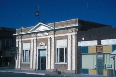 | First National Bank of Haxtun | building | 1986 | 86001454 |
| Hargreaves Homestead Rural Historic District | district | 2013 | 13000873 | |
| Harms Farm | district | 2016 | 15001010 | |
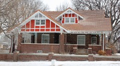 | W. E. Heginbotham House | district | 1988 | 88000170 |
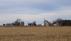 | Millage Farm Rural Historic District | district | 2013 | 13000874 |
| Oltjenbruns Farm | district | 2016 | 15001011 | |
 | Phillips County Courthouse | building | 2007 | 07001306 |
| Reimer-Smith Oil Station | building | 2000 | 00000323 | |
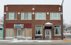 | Shirley Hotel | building | 2002 | 02000263 |
Every wildfire the federal occurrence database records inside this county: 51 of them, burning about 2,161 acres. 1 started naturally and none was recorded as arson. Each settlement page carries the fires within five miles of it.
| Reported cause | Fires |
|---|---|
| Missing data/not specified/undetermined | 49 |
| Smoking | 1 |
| Natural | 1 |
The five largest, by the area the report gives. None of them was recorded as arson.
| Date | Cause | Size | Reported by | Name on the report |
|---|---|---|---|---|
| 30 June 2020 | Missing data/not specified/undetermined | 750 acres | Phillips County | COUNTY RD 49 |
| 1 July 2020 | Missing data/not specified/undetermined | 617 acres | Phillips County | BALI NEIL |
| 9 April 2014 | Missing data/not specified/undetermined | 120 acres | Holyoke Volunteer Fire Department | UNKNOWN |
| 22 March 2004 | Missing data/not specified/undetermined | 100 acres | Colorado State Forest Service-State Headquarters | not named |
| 22 March 2004 | Missing data/not specified/undetermined | 100 acres | Colorado State Forest Service-State Headquarters | not named |
| 17 March 2011 | Missing data/not specified/undetermined | 100 acres | Colorado State Forest Service-State Headquarters | HOLYOKE |
| 13 June 2013 | Missing data/not specified/undetermined | 100 acres | Holyoke Volunteer Fire Department | UNKNOWN |
| 27 June 2011 | Missing data/not specified/undetermined | 100 acres | Colorado State Forest Service-State Headquarters | HOLYOKE |
Every settlement page carries the fires within five miles of it - see the settlement index below.
The NOAA Storm Events Database holds 405 reports for this county, causing no deaths, 2 injuries and about $2,133,530 in recorded property damage. Each settlement page carries the reports that name it.
| Kind of event | Reports |
|---|---|
| Hail | 219 |
| Thunderstorm Wind | 121 |
| Tornado | 50 |
| Flash Flood | 12 |
| Flood | 2 |
| Heavy Rain | 1 |
The most serious of them, by death, then injury, then recorded damage. The accounts are quoted exactly as the forecast office filed them.
| When | Event | Place named | Harm | What the report says |
|---|---|---|---|---|
| June 1955 | Tornado (F2) | not stated | 1 hurt, $250,000 | no account filed |
| May 2004 | Thunderstorm Wind | Holyoke | 1 hurt | Strong thunderstorm winds flipped over a travel trailer at a mobile home park. One of the occupants had to be treated for minor cuts and bruises. A couple of blocks away, a cover from a skylight was ripped away from the roof of another residence. The strong winds also downed several large branches in the immediate area. |
| July 2006 | Thunderstorm Wind | Holyoke | $1,000,000 | Stong thunderstorm winds ruptured a large storage bin containing 85,000-90,000 bushels of popcorn at Jack's Bean Company southeast of Holyoke. When the large bin ruptured, the collapse damaged two smaller 55,000 bushel bins adjacent to it. In addition, a trailer and shed were extensively damaged. |
| May 1991 | Tornado (F1) | not stated | $250,000 | no account filed |
| June 1955 | Tornado (F2) | not stated | $250,000 | no account filed |
| June 2007 | Flash Flood | Amherst | $100,000 | no account filed |
| June 1994 | Thunderstorm Wind | Haxton | $50,000 | Thunderstorm winds damaged an airplane and two hangers as well as landing lights and a beacon at an airport southeast of Haxton (30 miles east of Sterling). |
| June 2009 | Flash Flood | Holyoke | $30,000 | Floodwaters up to one foot in depth were reportedly running over U.S. Highway 385. In addition, flash flooding from heavy rains washed out portions of several roads between County Roads 10 and 21. |
| August 2021 | Flash Flood | Holyoke | $25,000 | Thunderstorms produced very heavy rain in southeast Phillips County. Local law enforcement reported several roads were flooded southeast of Holyoke. Rainfall measurements from 4 to 9 inches were reported. Several houses had water rise up to the front doors. Significant flash flooding was observed 6 miles east of Holyoke on U.S. Highway 6. Widespread flooding of roads, ditches, and fields was reported. At least one road crossing Frenchman Creek was impassable. Frenchman Creek and other streams had significant flooding as well. |
| June 2010 | Flash Flood | Amherst | $25,000 | Heavy rain washed out sections of 20 country roads in Phillips County. |
| August 1976 | Tornado | not stated | $25,000 | no account filed |
| August 1976 | Tornado | not stated | $25,000 | no account filed |
| May 1965 | Tornado (F2) | not stated | $25,000 | no account filed |
| August 2021 | Tornado (EF1) | Holyoke Arpt | $20,000 | A tornado touched down and destroyed two outbuildings. It also rolled a semi trailer. |
| June 2009 | Hail | Haxtun | $20,000 | A severe thunderstorm caused extensive damage to wheat and corn crops in the immediate area. Out of 104,000 planted acres of wheat in Phillips County; 3,000 were destroyed. Sixty thousand additional acres were damaged. Out of 102,000 planted acres of corn in the county; 2,000 were completely destroyed and 20,500 were damaged. |
| August 2003 | Thunderstorm Wind | Haxtun | $20,000 | Strong thunderstorm winds downed a tree which crashed on to a home. The force of the blow punctured a hole in the ceiling, and knocked drywall into the laundry room. |
| June 1995 | Thunderstorm Wind | Haxtun | $5,500 | Wet microburst, straight-line winds estimated in excess of 75 knots ripped through the Haxtun vicinity as a second round of thunderstorms moved through the area. The winds flipped two corner irrigation sytems on to the adjacent road, toppled a few grain bins and removed some shingles off of a roof. A 70-foot evergreen tree had been toppled along with some smaller trees. |
| April 2021 | Flood | Haxtun Muni Arpt | $5,000 | Storm totals ranged from 4 to 8 inches. The flooding forced the closure of State Highway 59 south of Haxtun. |
| April 2013 | Thunderstorm Wind | Holyoke | $5,000 | Severe thunderstorm winds knocked down a telephone pole. |
| July 1971 | Tornado (F1) | not stated | $2,500 | no account filed |
| August 1994 | Tornado (F0) | Haxtun (8NE) | $500 | A tornado, which was estimated to be 50 feet wide and a quarter mile on the ground, passed through a feed lot with damage sustained to cattle buildings and feeders. |
| July 1953 | Tornado | not stated | $30 | no account filed |
| May 2025 | Thunderstorm Wind | Holyoke | - | County dispatch reported two trees down on houses within Holyoke, along with other tree damage and power outages. Time estimated. |
| May 2025 | Thunderstorm Wind | Amherst | - | The report was from a Weatherlink weather station. |
| May 2025 | Thunderstorm Wind | Holyoke Arpt | - | The report was from a weatherlink station. |
| May 2025 | Thunderstorm Wind | Paoli | - | The report was from a weatherlink station. |
| May 2025 | Thunderstorm Wind | Holyoke | - | Mesonet station US 385 south of Holyoke. |
| May 2025 | Thunderstorm Wind | Haxtun Muni Arpt | - | Wunderground weather station. |
| May 2025 | Thunderstorm Wind | Holyoke | - | Mesonet station along US 385 south of Holyoke. |
| May 2025 | Thunderstorm Wind | Holyoke Arpt | - | Awos station HEQ Holyoke Airport. |
| August 2025 | Thunderstorm Wind | Holyoke | - | The report was received from mesonet station AW276 Holyoke. |
| August 2025 | Thunderstorm Wind | Holyoke Arpt | - | The report was from AWOS station HEQ Holyoke Airport. |
| August 2025 | Thunderstorm Wind | Paoli | - | The report was from WeatherLink station WL-Paoli 3 miles west. |
| August 2025 | Thunderstorm Wind | Holyoke | - | The report was from mesonet station CO048 US 385 Holyoke. |
| June 2025 | Thunderstorm Wind | Holyoke | - | CDOT station south of Holyoke on US 385. |
| August 2024 | Thunderstorm Wind | Holyoke | - | The mesonet station CO048 U.S. 385 Holyoke from CDOT reported the wind gust. |
| July 2024 | Thunderstorm Wind | Holyoke Arpt | - | Measured gust from KHEQ Holyoke Airport. |
| July 2024 | Thunderstorm Wind | Holyoke | - | A CDOT sensor on US-385 south of Holyoke reported a wind gust of 74mph and a sustained wind of 57mph. |
| July 2024 | Hail | Amherst | - | The report was from mping. |
| July 2024 | Thunderstorm Wind | Paoli | - | A trained spotter reported estimated wind gusts up to 60 mph along with very heavy rain. The wind knocked a few small limbs down. |
| June 2024 | Thunderstorm Wind | Holyoke | - | This was recorded on a CDOT weather sensor. |
| September 2024 | Thunderstorm Wind | Holyoke | - | Weather station CO048 US 385 Holyoke. |
| August 2023 | Thunderstorm Wind | Haxtun Muni Arpt | - | Intense thunderstorm winds destroyed some irrigation equipment. |
| June 2022 | Tornado (EFU) | Amherst | - | A landspout touched down in an open field; no damage was observed. |
| June 2022 | Tornado (EFU) | Holyoke Arpt | - | A landspout touched down briefly in an open field; no damage was observed. |
| August 2021 | Tornado (EF0) | Holyoke Arpt | - | A weak tornado touched down in an open field, but no damage was reported. |
| August 2021 | Tornado (EF0) | Holyoke Arpt | - | A tornado touched down briefly in an open field. No damage was observed. |
| July 2020 | Tornado (EF0) | Amherst | - | A tornado touched down briefly near the intersection of CO 16 and CO 55. No damage was observed. |
| July 2020 | Tornado (EF0) | Paoli | - | A weak tornado touched down briefly in an open field. No damage was observed. |
| June 2020 | Thunderstorm Wind | Haxtun | - | Macroburst winds downed power lines and damaged several buildings. |
| May 2019 | Tornado (EF0) | Holyoke | - | A tornado touched down briefly in an open field. No damage was observed. |
| May 2019 | Tornado (EF0) | Holyoke Arpt | - | A tornado touched down briefly in an open field. No damage was observed. |
| September 2019 | Hail | Paoli | - | The hail damaged broke several windows to a house and damaged vehicles. |
| September 2019 | Hail | Amherst | - | Hail broke a windshield. |
| July 2019 | Tornado (EF0) | Holyoke | - | A small tornado touched down in an open field; no damage was observed. |
| August 2019 | Thunderstorm Wind | Amherst | - | Intense straight-line winds flipped a mobile home and damaged an adjacent home. |
| July 2018 | Hail | Amherst | - | Large hail the size of baseballs broke windshields and damaged trees. |
| June 2016 | Tornado (EF0) | Paoli | - | A tornado touched down briefly but did no damage. |
| June 2016 | Hail | Paoli | - | Large hail and strong winds shattered windows to homes and vehicles. |
| July 2016 | Thunderstorm Wind | Holyoke | - | Intense straight-line winds downed trees. The storm also produced dime size hail. |
The Survey's mineral resources record lists 8 workings inside this county. None of them still produces: all are closed or unrecorded. Each settlement page carries the workings within five miles of it.
| Commodity | Workings |
|---|---|
| Sand and Gravel, Construction | 8 |
The least common of them first, because a county's hundredth gravel pit says nothing its first ten did not.
| Where | Site | Commodity | Status | Recorded |
|---|---|---|---|---|
| Borrow Pit | Sand and Gravel, Construction | Past Producer | ||
| Unk | Sand and Gravel, Construction | Past Producer | ||
| Unk | Sand and Gravel, Construction | Past Producer | ||
| Unk | Sand and Gravel, Construction | Past Producer | ||
| Unk | Sand and Gravel, Construction | Past Producer | ||
| Unknown | Sand and Gravel, Construction | Occurrence | Sedimentary | |
| Unknown | Sand and Gravel, Construction | Occurrence | Sedimentary | |
| Unknown | Sand and Gravel, Construction | Occurrence | Sedimentary |
Named settlements recorded in the Geographic Names Information System, each with the topographic sheets covering it. Villages, hamlets and abandoned places alike. Each is shown with the nearest named watercourse or landform and the survey quadrangle it falls on.
Holyoke census division · 80734 · On North Fork Frenchman Creek · Holyoke quadrangle
6 sheets, 1954 to 1983