 Block
From the record
3 National Register listings published here.
Sources: the National Register database, National Park Service
20 topographic sheets cover 5 settlements here, and 3 properties are on the National Register of Historic Places.
3 National Register listings published here.
Sources: the National Register database, National Park Service
Every property in this county listed on the National Register of Historic Places, with the year it was listed and the federal nomination document.
| Photograph | Property | Type | Listed | Reference |
|---|---|---|---|---|
| Gibello's Caves | site | 2025 | 100011624 | |
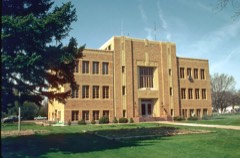 | Sedgwick County Courthouse | building | 2007 | 07000345 |
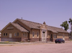 | Union Pacific Railroad Julesburg Depot | building | 2004 | 04000019 |
Every wildfire the federal occurrence database records inside this county: 45 of them, burning about 1,687 acres. 5 started naturally and none was recorded as arson. Each settlement page carries the fires within five miles of it.
| Reported cause | Fires |
|---|---|
| Missing data/not specified/undetermined | 21 |
| Equipment and vehicle use | 8 |
| Natural | 5 |
| Smoking | 5 |
| Debris and open burning | 4 |
| Railroad operations and maintenance | 2 |
The five largest, by the area the report gives. None of them was recorded as arson.
| Date | Cause | Size | Reported by | Name on the report |
|---|---|---|---|---|
| 8 July 2017 | Missing data/not specified/undetermined | 1,300 acres | Sedgwick County | MILE MARKER 173 |
| 28 July 2015 | Railroad operations and maintenance | 200 acres | Sedgwick Volunteer Fire Department | UNKNOWN |
| 13 November 2011 | Missing data/not specified/undetermined | 85 acres | Colorado State Forest Service-State Headquarters | JULESBURG |
| 13 June 2013 | Natural | 15 acres | Wages Volunteer Fire Department (Yuma Rural Fire Protection District) | UNKNOWN |
| 6 June 2018 | Natural | 15 acres | Sedgwick Volunteer Fire Department | UNKNOWN |
| 1 October 2011 | Missing data/not specified/undetermined | 13 acres | Colorado State Forest Service-State Headquarters | JULESBURG |
| 31 May 2013 | Debris and open burning | 10 acres | Wages Volunteer Fire Department (Yuma Rural Fire Protection District) | UNKNOWN |
| 31 July 2011 | Missing data/not specified/undetermined | 10 acres | Colorado State Forest Service-State Headquarters | SEDGWICK |
Every settlement page carries the fires within five miles of it - see the settlement index below.
The NOAA Storm Events Database holds 298 reports for this county, causing 2 deaths, 10 injuries and about $573,310 in recorded property damage. Each settlement page carries the reports that name it.
| Kind of event | Reports |
|---|---|
| Hail | 182 |
| Thunderstorm Wind | 63 |
| Tornado | 43 |
| Flash Flood | 7 |
| Lightning | 2 |
| Flood | 1 |
The most serious of them, by death, then injury, then recorded damage. The accounts are quoted exactly as the forecast office filed them.
| When | Event | Place named | Harm | What the report says |
|---|---|---|---|---|
| June 1960 | Tornado (F3) | not stated | 2 killed, 3 hurt, $250,000 | no account filed |
| September 1992 | Tornado (F0) | not stated | 4 hurt, $25,000 | no account filed |
| August 1950 | Tornado (F2) | not stated | 1 hurt, $25,000 | no account filed |
| June 1999 | Tornado (F1) | Ovid | 1 hurt | no account filed |
| June 1951 | Tornado (F1) | not stated | 1 hurt | no account filed |
| June 2007 | Flash Flood | Julesburg | $100,000 | no account filed |
| June 2007 | Flash Flood | Julesburg | $100,000 | no account filed |
| April 2015 | Tornado (EF1) | Marks Butte | $25,000 | A tornado touched down briefly. A grain bin was destroyed and a power pole was knocked down. |
| August 1950 | Tornado (F2) | not stated | $25,000 | no account filed |
| August 2011 | Flash Flood | Ovid | $10,000 | A severe thunderstorm produced minor flash flooding. |
| July 2008 | Thunderstorm Wind | Julesburg | $5,000 | no account filed |
| May 1990 | Tornado (F0) | not stated | $2,500 | no account filed |
| July 1960 | Tornado (F2) | not stated | $2,500 | no account filed |
| June 1953 | Tornado (F1) | not stated | $2,500 | no account filed |
| May 1962 | Tornado (F1) | not stated | $250 | no account filed |
| May 1951 | Tornado (F0) | not stated | $250 | no account filed |
| May 1951 | Tornado (F1) | not stated | $250 | no account filed |
| May 1962 | Tornado (F0) | not stated | $30 | no account filed |
| May 1951 | Tornado (F0) | not stated | $30 | no account filed |
| May 2025 | Thunderstorm Wind | Ovid | - | The report was from a weatherlink station. |
| August 2025 | Thunderstorm Wind | Julesburg | - | The report east from mesonet station CO034 I-76 Julesburg. |
| July 2024 | Hail | Dorsey | - | The report was from mping. |
| July 2024 | Hail | Julesburg | - | The report was from mping. |
| July 2024 | Hail | Marks Butte | - | The time was estimated. |
| July 2024 | Hail | Marks Butte | - | The time was estimated. |
| July 2024 | Thunderstorm Wind | Julesburg | - | Mesonet station CO034, I-76 Julesburg. |
| June 2024 | Hail | Ovid | - | A mping report. |
| June 2024 | Thunderstorm Wind | Julesburg | - | Also observed quarter size hail. |
| June 2024 | Thunderstorm Wind | Julesburg | - | Measured at a CDOT sensor on I-76 near Julesburg. |
| June 2024 | Thunderstorm Wind | Julesburg Muni Arpt | - | From the mesonet station UP469, 2.3 miles northeast of Ovid. |
| June 2022 | Tornado (EFU) | Sedgwick | - | A tornado touched down in an open field; no damage was observed. |
| June 2022 | Tornado (EFU) | Sedgwick | - | A tornado touched down in an open field; no damage was observed. |
| June 2020 | Hail | Dorsey | - | Very large hail accompanied by wind gusts to 50 mph broke several car windows. |
| July 2020 | Tornado (EF0) | Julesburg | - | A tornado touched down briefly in an open field. No damage was reported. |
| July 2020 | Tornado (EF0) | Julesburg | - | A weak tornado touched down briefly. No damage was observed. |
| July 2020 | Tornado (EF0) | Julesburg | - | A tornado touched down briefly near the intersection of CO 12 and CO 53. No damage was reported. |
| July 2020 | Tornado (EF0) | Julesburg | - | A tornado touched down briefly near the intersection of CO 18 and U.S. Highway 385. No damage was observed. |
| July 2020 | Tornado (EF0) | Julesburg | - | A tornado touched down briefly and damaged an unoccupied building near the intersection of CO 16 AND CO 55. |
| June 2020 | Thunderstorm Wind | Julesburg | - | Intense winds snapped tree limbs up to 2 inches in diameter. |
| May 2019 | Tornado (EF0) | Marks Butte | - | A tornado touched down and caused minor damage to 20,000 bushel capacity grain bins. Ten of 12 grain bins were damaged; some by downed pipes that fell on them. |
| May 2019 | Hail | Ovid | - | Heavy rainfall was also observed. |
| September 2019 | Hail | Julesburg | - | Several windows at a home were broken. |
| June 2018 | Tornado (EF0) | Julesburg | - | A weak tornado touched down briefly in an open field. No damage was observed. |
| June 2018 | Thunderstorm Wind | Julesburg | - | Intense thunderstorm winds blew down power poles in and around Julesburg, knocking out the power. Crop damage was also reported west of Julesburg. |
| July 2018 | Hail | Julesburg | - | Baseball size hail shattered a windshield. |
| July 2018 | Thunderstorm Wind | Julesburg | - | Intense thunderstorm winds blew down power lines. In addition, a trailer was blown on its side near I-76 and the stateline. |
| July 2018 | Thunderstorm Wind | Julesburg | - | Strong winds and large hail caused extensive damage to an assisted living facility. |
| July 2018 | Hail | Julesburg | - | The large hail broke the windows on one side of the house. |
| June 2016 | Tornado (EF0) | Julesburg | - | A tornado touched down briefly but did no damage. |
| June 2016 | Hail | Julesburg | - | Very strong winds were also observed. |
| June 2014 | Tornado (EF0) | Dorsey | - | A tornado touched down briefly. No damage was observed. |
| June 2014 | Thunderstorm Wind | Julesburg Muni Arpt | - | Thunderstorm winds downed several trees. |
| September 2013 | Flood | Sedgwick | - | The extent if the damage was minimal and confined to areas west of Sedgwick which included County Roads 1,3,5,7 and 41. |
| May 2011 | Thunderstorm Wind | Julesburg | - | Intense thunderstorms winds snapped a tree in two, causing the top of the tree to fall on to the backside of a home. |
| June 2011 | Thunderstorm Wind | Julesburg | - | Intense straightline winds knocked down a 50-foot tree. |
| June 2011 | Tornado (EF0) | Sedgwick | - | A tornado touched down briefly but did no damage. |
| June 2010 | Thunderstorm Wind | Julesburg | - | A gift shop in Julesburg sustained damaged when debris shattered a large window. |
| March 2007 | Tornado (EF0) | Julesburg | - | A small tornado touched down but did no damage. |
| April 2006 | Lightning | Julesburg | - | Lightning struck a tree adjacent to Saint Anthony's Catholic Church. The blast split the tree and broke several windows of the nearby church. |
| June 2004 | Tornado (F0) | Ovid | - | A tornado touched down but did no damage. |
The Survey's mineral resources record lists 40 workings inside this county. 2 still produce and 38 are closed or unrecorded. Each settlement page carries the workings within five miles of it.
| Commodity | Workings |
|---|---|
| Sand and Gravel, Construction | 36 |
| Fire Clay (Refractory) | 2 |
| Sand and Gravel, Construction, Gemstone | 1 |
| Iron | 1 |
The least common of them first, because a county's hundredth gravel pit says nothing its first ten did not.
| Where | Site | Commodity | Status | Recorded |
|---|---|---|---|---|
| Ovid Limekiln | Iron | Producer | ||
| Unknown | Sand and Gravel, Construction, Gemstone | Producer | ||
| Unknown | Fire Clay (Refractory) | Occurrence | Sedimentary | |
| Unknown | Fire Clay (Refractory) | Occurrence | Sedimentary | |
| Ovid | Sand and Gravel, Construction | Past Producer | ||
| Unk | Sand and Gravel, Construction | Past Producer | ||
| Unk | Sand and Gravel, Construction | Unknown | ||
| Unk | Sand and Gravel, Construction | Unknown | ||
| Unk | Sand and Gravel, Construction | Unknown | ||
| Unk | Sand and Gravel, Construction | Unknown | ||
| Unk | Sand and Gravel, Construction | Unknown | ||
| Unk | Sand and Gravel, Construction | Unknown | ||
| Unk | Sand and Gravel, Construction | Unknown | ||
| Unk | Sand and Gravel, Construction | Unknown | ||
| Unk | Sand and Gravel, Construction | Unknown | ||
| Unk | Sand and Gravel, Construction | Unknown | ||
| Unk | Sand and Gravel, Construction | Unknown | ||
| Unk | Sand and Gravel, Construction | Unknown | ||
| Unk | Sand and Gravel, Construction | Past Producer | ||
| Unk | Sand and Gravel, Construction | Unknown | ||
| Unk | Sand and Gravel, Construction | Unknown | ||
| Unk | Sand and Gravel, Construction | Unknown | ||
| Unk | Sand and Gravel, Construction | Unknown | ||
| Unk | Sand and Gravel, Construction | Unknown | ||
| Unk | Sand and Gravel, Construction | Unknown | ||
| Unk | Sand and Gravel, Construction | Past Producer | ||
| Unk | Sand and Gravel, Construction | Unknown | ||
| Unk | Sand and Gravel, Construction | Unknown | ||
| Unk | Sand and Gravel, Construction | Unknown | ||
| Unk | Sand and Gravel, Construction | Unknown | ||
| Unk | Sand and Gravel, Construction | Past Producer | ||
| Unknown | Sand and Gravel, Construction | Occurrence | Sedimentary | |
| Unknown | Sand and Gravel, Construction | Occurrence | Sedimentary | |
| Unknown | Sand and Gravel, Construction | Occurrence | Sedimentary | |
| Unknown | Sand and Gravel, Construction | Occurrence | Sedimentary | |
| Unknown | Sand and Gravel, Construction | Occurrence | Sedimentary | |
| Unknown | Sand and Gravel, Construction | Occurrence | Sedimentary | |
| Unknown | Sand and Gravel, Construction | Occurrence | Sedimentary | |
| Unknown | Sand and Gravel, Construction | Occurrence | Sedimentary | |
| Unknown | Sand and Gravel, Construction | Occurrence | Sedimentary |
Named settlements recorded in the Geographic Names Information System, each with the topographic sheets covering it. Villages, hamlets and abandoned places alike. Each is shown with the nearest named watercourse or landform and the survey quadrangle it falls on.
South Sedgwick census division · 80737 · Julesburg quadrangle
10 sheets, 1953 to 1983
No longer a settlement
South Sedgwick census division · 80744 · On Lodgepole Creek · Ovid quadrangle
12 sheets, 1953 to 1983
No longer a settlement
Julesburg census division · 80744 · On Lodgepole Creek · Ovid quadrangle
12 sheets, 1953 to 1983
The vanished settlements of Sedgwick County: the places named above that are no longer on the map.