 Block
From the record
4 National Register listings published here.
Sources: the National Register database, National Park Service
46 topographic sheets cover 22 settlements here, and 4 properties are on the National Register of Historic Places.
4 National Register listings published here.
Sources: the National Register database, National Park Service
Every property in this county listed on the National Register of Historic Places, with the year it was listed and the federal nomination document.
| Photograph | Property | Type | Listed | Reference |
|---|---|---|---|---|
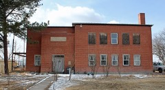 | Akron Gymnasium | building | 2008 | 07001397 |
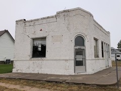 | Farmers State Bank of Cope | building | 2017 | 100000952 |
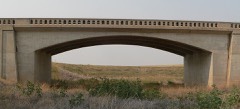 | Plum Bush Creek Bridge | structure | 2002 | 02001135 |
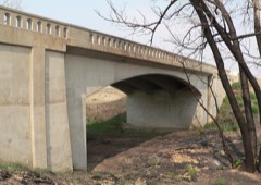 | West Plum Bush Creek Bridge | structure | 2002 | 02001136 |
Every wildfire the federal occurrence database records inside this county: 212 of them, burning about 54,689 acres. 36 started naturally and 1 was recorded as arson. Each settlement page carries the fires within five miles of it.
| Reported cause | Fires |
|---|---|
| Missing data/not specified/undetermined | 121 |
| Natural | 36 |
| Equipment and vehicle use | 31 |
| Debris and open burning | 8 |
| Recreation and ceremony | 7 |
| Smoking | 5 |
| Railroad operations and maintenance | 2 |
| Arson/incendiarism | 1 |
| Fireworks | 1 |
The five largest, by the area the report gives. None of them was recorded as arson.
| Date | Cause | Size | Reported by | Name on the report |
|---|---|---|---|---|
| 25 June 2012 | Missing data/not specified/undetermined | 45,000 acres | Fort Collins Interagency Dispatch Center | LAST CHANCE |
| 3 March 2018 | Equipment and vehicle use | 4,300 acres | Southwest Washington County Fire Protection District | UNKNOWN |
| 31 October 2010 | Natural | 1,200 acres | Colorado State Forest Service-State Headquarters | not named |
| 6 July 2017 | Equipment and vehicle use | 1,000 acres | Otis Fire Department | UNKNOWN |
| 19 September 2018 | Equipment and vehicle use | 320 acres | Akron Volunteer Fire Department | UNKNOWN |
| 30 October 2016 | Missing data/not specified/undetermined | 300 acres | Southwest Washington County Fire Protection District | UNKNOWN |
| 14 August 2011 | Missing data/not specified/undetermined | 300 acres | Colorado State Forest Service-State Headquarters | LSAT CHANCE |
| 6 July 1994 | Natural | 200 acres | Yuma County | not named |
Every settlement page carries the fires within five miles of it - see the settlement index below.
The NOAA Storm Events Database holds 1,104 reports for this county, causing no deaths, 7 injuries and about $16,416,120 in recorded property damage. Each settlement page carries the reports that name it.
| Kind of event | Reports |
|---|---|
| Hail | 651 |
| Tornado | 210 |
| Thunderstorm Wind | 208 |
| Flash Flood | 24 |
| Flood | 5 |
| Lightning | 3 |
| Funnel Cloud | 2 |
| Heavy Rain | 1 |
The most serious of them, by death, then injury, then recorded damage. The accounts are quoted exactly as the forecast office filed them.
| When | Event | Place named | Harm | What the report says |
|---|---|---|---|---|
| June 1967 | Tornado (F1) | not stated | 4 hurt, $2,500 | no account filed |
| August 2004 | Flash Flood | Central Portion | 3 hurt | Strong thunderstorms, producing up to 3 inches of rain, triggered flash flooding over parts of central Washington County. The floodwaters tipped over a mobile home. The occupants suffered only minor injuries. A deputy patrolling the area was also caught in the floodwaters, as his vehicle was washed approximately 100 yards into a field. The deputy was not injured. |
| September 2013 | Flood | Messex | $10,000,000 | The flood crest moving down the South Platte River completely submerged the community of Messex and forced the evacuation of the small community for several days. The railroad tracks, owned by the Burlington Northern Santa Fe Railway on the west side of the river, suffered extensive damage. In addition, a section of CO63 was also damaged. Several small bridges and county roads were washed out by flooding around Messex including Washington County Roads 59, N and WW. The entrance and exit ramps of Interstate 76 to Barlow Road were closed due to flooding. Fiber optic cables were also damaged during the flood. |
| June 2015 | Flood | Messex | $5,000,000 | A levee breach, about 100 yards wide along the South Platte River, produced farmland flooding over northwest Washington County. Floodwaters, 3 to 4 feet deep, washed out the Union Pacific railroad tracks southwest of Messex. Up to 10 inches of water covered several miles of track. Approximately 30 trains per day had to be diverted until the tracks could be repaired and inspected. Washington County Road 58.3 was also washed out. |
| May 1996 | Tornado (F3) | Elba | $300,000 | no account filed |
| June 1952 | Tornado (F2) | not stated | $250,000 | no account filed |
| September 1998 | Thunderstorm Wind | Anton | $200,000 | Damaging thunderstorm winds toppled the leg of a grain elevator in Anton. Some trees in the immediate area were also split. The peak wind gust was estimated. |
| September 2014 | Flash Flood | Burdett | $100,000 | Strong thunderstorms producing up to 4 inches of rainfall, caused flash flooding. State Highway 61 was closed following an accident involving a semi-truck. Several sections of the highway experienced flooding. Extensive flooding was also observed in fields and ditches north and west along the highway towards Sterling. Several county roads were reportedly washed out. |
| June 2023 | Flood | (Ako)Akron Weather Station | $50,000 | Law enforcement reported that flooding forced the closure of CO-63 between Akron and Anton. Rainfall totals ranged from 3 to 5 inches in the area. |
| September 2014 | Flash Flood | Akron | $50,000 | Heavy rain, up to 3 inches in one hour, washed out numerous county roads along a 10-mile swath stretching from southwest of Akron to southeast of Otis. Water reportedly ran across CO 36 east of Anton at Washington County Road HH. A reverse 911 notification was sent to residents in a 10 by 13 mile area. |
| August 2013 | Flash Flood | Last Chance | $50,000 | Heavy rain producing thunderstorms caused extensive flooding of creeks and fields. Numerous dirt roads were damaged or washed out completely. |
| August 2002 | Flash Flood | Southeast Portion | $50,000 | Severe thunderstorms producing large hail and heavy rain caused flash flooding over sections of southeast Washington County. Flooding occurred on State Highway 63, north of Akron, and along County Road 57. Floodwaters along the highway caused several cars, including a sheriff's vehicle, to slide into the ditch. There was also 2 feet of water reportedly covering highway 61, approximately 13 miles north of Otis. |
| August 2002 | Flash Flood | Southeast Portion | $50,000 | Heavy rain triggered flash flooding over southeastern Washington. Five county roads were washed out during the storm. |
| August 2023 | Thunderstorm Wind | Hyde | $30,000 | Very strong winds flipped a small barn on its side and caused minor shingle damage to a manufactured home. |
| June 1996 | Hail | Akron | $30,000 | no account filed |
| June 2005 | Lightning | Akron | $25,000 | Lightning struck two oil refinery tanks. One of the tanks lost approximately 500 barrels of crude oil. |
| June 1992 | Tornado (F0) | not stated | $25,000 | no account filed |
| May 1991 | Tornado (F0) | not stated | $25,000 | no account filed |
| May 1975 | Tornado (F3) | not stated | $25,000 | no account filed |
| April 1955 | Tornado | not stated | $25,000 | no account filed |
| April 2013 | Thunderstorm Wind | Akron | $20,000 | Severe thunderstorm winds blew over and destroyed a mobile home. |
| June 2023 | Tornado (EF2) | Elba | $15,000 | A large tornado with estimated peak winds to 118 mph, snapped power poles as it crossed Highway 63. |
| June 2015 | Flash Flood | Akron Arpt | $15,000 | Flash flooding occurred along U.S. Highway 34. |
| June 2023 | Flash Flood | Elba | $10,000 | Rushing water observed overtopping CO-63 north of Elba. A trained spotter near Elba measured a total of 4.2 inches of rainfall. |
| July 2013 | Flash Flood | Otis Stansfield Arpt | $10,000 | Heavy rain produced flash flooding along Colorado Highway 61 and Mile Marker 15. All the county roads east of the highway and north of County Road 54 were closed by floodwaters. Extensive flooding washed out several of the county roads. |
| May 2011 | Flash Flood | Otis Stansfield Arpt | $10,000 | Water up to a foot deep was reportedly running over County Road P, just north of State Highway 6; and several spots along County Road ZZ. A trained spotter measured 3.27 inches of rainfall 10 miles northwest of Yuma. |
| August 2008 | Flash Flood | Messex | $10,000 | Heavy rain caused considerable damage to several county roads and culverts south of Akron. |
| July 2022 | Flash Flood | Otis Stansfield Arpt | $5,000 | Six inches of water was observed running across County Road 44 at Highway 61. |
| July 2019 | Thunderstorm Wind | Akron Arpt | $5,000 | Strong winds damaged a patio roof and flag pole. |
| June 2008 | Flash Flood | Akron | $5,000 | Officials in Washington County reported roadways northwest of Akron were inundated by floodwaters. |
| July 2008 | Flash Flood | Pinneo | $5,000 | Heavy rain forced the closure of State Highway 34. |
| May 1994 | Thunderstorm Wind | Otis | $5,000 | Thunderstorm winds, estimated at 60 mph (52 knots) by spotters, destroyed a hog shed and killed a hog northwest of Otis (12 miles east of Akron). The winds also blew a tin roof off a barn. |
| August 2008 | Thunderstorm Wind | Akron | $5,000 | no account filed |
| July 1969 | Tornado (F0) | not stated | $2,500 | no account filed |
| July 1958 | Tornado (F2) | not stated | $2,500 | no account filed |
| March 1954 | Tornado | not stated | $2,500 | no account filed |
| July 1994 | Thunderstorm Wind | Akron | $500 | Thunderstorm winds knocked down power poles in Akron. |
| May 1982 | Tornado (F2) | not stated | $250 | no account filed |
| April 1957 | Tornado (F0) | not stated | $250 | no account filed |
| June 1983 | Tornado (F1) | not stated | $30 | no account filed |
| June 1982 | Tornado (F1) | not stated | $30 | no account filed |
| May 1960 | Tornado (F2) | not stated | $30 | no account filed |
| July 1958 | Tornado | not stated | $30 | no account filed |
| June 2025 | Thunderstorm Wind | Akron | - | Microburst at CoAgMET station. Time of gust estimated due to gust observations only reported at top of hour. |
| August 2025 | Thunderstorm Wind | (Ako)Akron Weather Station | - | The AWOS station KAKO Akron reported the wind gust. |
| May 2025 | Hail | Messex | - | Colorado Parks and Wildlife employee reported golf ball sized hail at Prewitt Reservoir. |
| May 2025 | Hail | (Ako)Akron Weather Station | - | Report from Mping. |
| May 2025 | Hail | (Ako)Akron Weather Station | - | Report from Mping. |
| May 2025 | Hail | Otis | - | Report from Mping. |
| May 2025 | Hail | Akron Arpt | - | Report from Mping. |
| May 2025 | Tornado (EF2) | Messex | - | Well documented tornado that moved south parallel to CO-63, remaining generally in open areas 2-3 miles west of CO-63. We obtained the width (400 yds) of the tornado based on power poles snapped along County Road 50. One single family residence was struck with minor damage to the house, and significant damage to all outbuildings and trees on the property, consistent with EF-1 damage. Debris from the property was carried approximately one mile to the south-southwest. Further south of the damaged property, power poles were snapped and thrown a considerable distance (25 yds), consistent with EF-2 intensity. The power poles were on the west side of AA, just north of County Road 48. Video evidence and the results of the storm survey, suggest that the tornado dissipated just before 6 PM MDT. |
| May 2025 | Hail | Akron | - | Report from Mping. |
| May 2025 | Hail | Messex | - | In-situ Collaborative Experiment for the Collection of Hail In the Plains (ICECHIP) reported the large hail. |
| May 2025 | Thunderstorm Wind | (Ako)Akron Weather Station | - | Located at the Akron airport AKO. |
| May 2025 | Thunderstorm Wind | Midway | - | Mesonet station near Brush. |
| May 2025 | Thunderstorm Wind | (Ako)Akron Weather Station | - | Measured at the Akron Airport, AKO. |
| July 2025 | Thunderstorm Wind | Cope | - | WeatherLink Station near Cope Colorado. |
| July 2025 | Hail | Burdett | - | Report from mping. |
| July 2025 | Hail | Otis | - | Reported via social media. Time and location estimated. |
| July 2025 | Hail | Otis | - | Retired NWS employee measured 3.9cm diameter hail in Otis approximately 20 minutes after it fell. |
The Survey's mineral resources record lists 29 workings inside this county. 1 still produces and 28 are closed or unrecorded. Each settlement page carries the workings within five miles of it.
| Commodity | Workings |
|---|---|
| Sand and Gravel, Construction | 26 |
| Gold | 1 |
| Stone | 1 |
| Pumice | 1 |
The least common of them first, because a county's hundredth gravel pit says nothing its first ten did not.
| Where | Site | Commodity | Status | Recorded |
|---|---|---|---|---|
| Unknown | Pumice | Past Producer | ||
| Unnamed Gold Occurrence | Gold | Occurrence | Placer | |
| Washington Granite Qy | Stone | Producer | ||
| Schoenecker Pit & Plant | Sand and Gravel, Construction | Past Producer | ||
| Unk | Sand and Gravel, Construction | Past Producer | ||
| Unk | Sand and Gravel, Construction | Past Producer | ||
| Unk | Sand and Gravel, Construction | Past Producer | ||
| Unk | Sand and Gravel, Construction | Past Producer | ||
| Unk | Sand and Gravel, Construction | Past Producer | ||
| Unk | Sand and Gravel, Construction | Past Producer | ||
| Unk | Sand and Gravel, Construction | Past Producer | ||
| Unk | Sand and Gravel, Construction | Past Producer | ||
| Unk | Sand and Gravel, Construction | Past Producer | ||
| Unk | Sand and Gravel, Construction | Past Producer | ||
| Unk | Sand and Gravel, Construction | Past Producer | ||
| Unk | Sand and Gravel, Construction | Past Producer | ||
| Unk | Sand and Gravel, Construction | Past Producer | ||
| Unk | Sand and Gravel, Construction | Past Producer | ||
| Unk | Sand and Gravel, Construction | Past Producer | ||
| Unk | Sand and Gravel, Construction | Past Producer | ||
| Unk | Sand and Gravel, Construction | Past Producer | ||
| Unk | Sand and Gravel, Construction | Past Producer | ||
| Unk | Sand and Gravel, Construction | Past Producer | ||
| Unk | Sand and Gravel, Construction | Past Producer | ||
| Unk | Sand and Gravel, Construction | Past Producer | ||
| Unknown | Sand and Gravel, Construction | Occurrence | Gravel | |
| Unknown | Sand and Gravel, Construction | Past Producer | ||
| Unknown | Sand and Gravel, Construction | Past Producer | ||
| Unknown | Sand and Gravel, Construction | Past Producer |
Named settlements recorded in the Geographic Names Information System, each with the topographic sheets covering it. Villages, hamlets and abandoned places alike. Each is shown with the nearest named watercourse or landform and the survey quadrangle it falls on.
Cope census division · 80720 · De Nova quadrangle
8 sheets, 1954 to 1983
No longer a settlement
The vanished settlements of Washington County: the places named above that are no longer on the map.