 Block
From the record
5 National Register listings published here.
Sources: the National Register database, National Park Service
57 topographic sheets cover 18 settlements here, and 5 properties are on the National Register of Historic Places.
5 National Register listings published here.
Sources: the National Register database, National Park Service
Every property in this county listed on the National Register of Historic Places, with the year it was listed and the federal nomination document.
| Photograph | Property | Type | Listed | Reference |
|---|---|---|---|---|
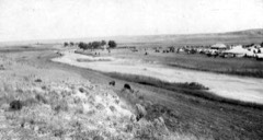 | Beecher Island Battleground | site | 1976 | 76000569 |
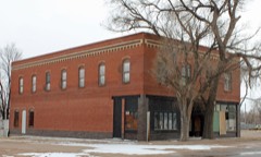 | Boggs Lumber and Hardware Building | building | 1985 | 85000086 |
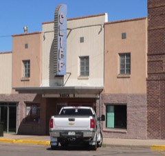 | Cliff Theater | building | 2013 | 13000577 |
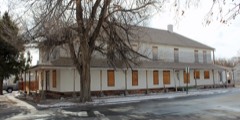 | Lett Hotel | building | 1990 | 89002378 |
| Walter and Anna Zion Homestead | district | 2005 | 05000652 |
Every wildfire the federal occurrence database records inside this county: 257 of them, burning about 33,472 acres. 37 started naturally and 1 was recorded as arson. Each settlement page carries the fires within five miles of it.
| Reported cause | Fires |
|---|---|
| Missing data/not specified/undetermined | 158 |
| Natural | 37 |
| Equipment and vehicle use | 30 |
| Recreation and ceremony | 8 |
| Smoking | 8 |
| Debris and open burning | 6 |
| Railroad operations and maintenance | 5 |
| Power generation/transmission/distribution | 3 |
| Arson/incendiarism | 1 |
| Fireworks | 1 |
The five largest, by the area the report gives. None of them was recorded as arson.
| Date | Cause | Size | Reported by | Name on the report |
|---|---|---|---|---|
| 18 March 2012 | Missing data/not specified/undetermined | 24,000 acres | Yuma County | HEARTSTRONG |
| 8 April 2014 | Missing data/not specified/undetermined | 2,500 acres | Yuma County | YUMA COUNTY |
| 4 April 2018 | Missing data/not specified/undetermined | 1,783 acres | Yuma County | COUNTY ROAD 56 |
| 15 October 2011 | Missing data/not specified/undetermined | 1,000 acres | Colorado State Forest Service-State Headquarters | HAIGLER |
| 10 July 1994 | Natural | 500 acres | Yuma County | not named |
| 5 September 2010 | Missing data/not specified/undetermined | 350 acres | Colorado State Forest Service-State Headquarters | not named |
| 10 March 2015 | Railroad operations and maintenance | 320 acres | Yuma Volunteer Fire Department (Yuma Rural Fire Protection District) | UNKNOWN |
| 31 October 2016 | Equipment and vehicle use | 300 acres | Wray Volunteer Fire Department (Yuma County Fire Protection District) | UNKNOWN |
Every settlement page carries the fires within five miles of it - see the settlement index below.
The NOAA Storm Events Database holds 1,536 reports for this county, causing no deaths, 18 injuries and about $12,498,380 in recorded property damage. Each settlement page carries the reports that name it.
| Kind of event | Reports |
|---|---|
| Hail | 1029 |
| Thunderstorm Wind | 349 |
| Tornado | 104 |
| Flash Flood | 33 |
| Flood | 11 |
| Funnel Cloud | 7 |
| Heavy Rain | 2 |
| Lightning | 1 |
The most serious of them, by death, then injury, then recorded damage. The accounts are quoted exactly as the forecast office filed them.
| When | Event | Place named | Harm | What the report says |
|---|---|---|---|---|
| October 1971 | Tornado (F2) | not stated | 9 hurt, $2,500,000 | no account filed |
| May 2016 | Tornado (EF2) | Wray Muni Arpt | 4 hurt, $135,000 | The tornado developed just north of the Wray airport. It remained semi-stationary for the first few minutes of its lifetime before moving north. The tornado crossed Highway 385 just north of the CR 39 intersection. As it crossed the highway it strewed barb wire fencing across the road, picked up a semi and the attached trailer, tossing them east of the highway. Cargo from the trailer was blown across the highway. A tractor parked near the highway was flipped on its side at this same location. Near this same location a mobile home had the roof removed by the tornado. Law enforcement reported around 40 electrical poles were down due to the tornado. According to law enforcement four people impacted by the tornado had minor injuries. The tornado's path was in the rural areas north of Wray. The tornado ended before reaching CR 45 east of Highway 385. |
| June 1972 | Tornado (F2) | not stated | 3 hurt, $25,000 | no account filed |
| July 1985 | Tornado (F2) | not stated | 2 hurt, $250,000 | no account filed |
| June 2011 | Thunderstorm Wind | Clarkville | $3,400,000 | At least two residences sustained major damage, and many others significant damage, as an intense thunderstorm moved over northeast Yuma county. Several large grain bins were destroyed with others damaged. One grain bin fell on a parked semi-trailer causing additional damage to the vehicle. Ten irrigation sprinkler systems was overturned, numerous trees were uprooted. Window and siding damage occurred at several residences with parts of roofs damaged. Y-W electric reported a loss of 44 utility poles. In addition, thousands of acres of cropland were impacted by the hail accompanying the storm. Dollar estimates of damage are approximate and based on figures from the USDA. |
| August 2023 | Tornado (EF3) | Yuma Arpt | $1,000,000 | The tornado began in far eastern Washington County near the town of Hyde and moved east-southeast into northwest Yuma County. In Yuma County, the tornado remained southwest of the city of Yuma, where it looped around three times along the path causing damage to irrigation pivots, trees, and numerous power poles. The tornado dissipated during a fourth large loop. There was also significant damage to a residential property, three grain bins, and a machine shed towards the end of the path. Image of the actual tornado path is attached. |
| June 2021 | Thunderstorm Wind | Yuma | $1,000,000 | Yuma County Emergency Manager reported sixty-eight power poles blown down along CR 48 north of the city of Yuma. Damage was estimated at 1 million dollars. |
| June 1998 | Hail | Yuma | $1,000,000 | Hail up to baseball size damaged windows, windshields, roofs, siding, and vehicles. Hail started as dime size at 2100 MST. |
| June 2010 | Tornado (EF1) | Vernon | $380,000 | A tornado developed about 6 miles SW of Vernon and tracked southeast, dissipating just west of Beecher Island. Winds estimated at 100 mph in the Rear Flank downdraft just south of the tornado also caused extensive damage. forty eight utility poles were downed, three irrigation pivots were overturned, a barn was destroyed, several trailer homes were damaged, and the roof of the small auditorium in Beecher Island was heavily damaged. |
| June 2008 | Hail | Yuma | $350,000 | This is the second major hail storm to impact the city of Yuma during the same afternoon. Golfball to baseball sized hail fell, and smaller hail under a half inch in diameter covered the ground to a depth of 1 foot. Some house windows were broken during this event. |
| June 2008 | Hail | Yuma | $350,000 | Large hail pelted Yuma Colorado and surrounding areas for over 30 minutes, causing hail to accumulate to a depth of 5 inches. Many hailstones were quarter sized but several reports of golf ball sized hail were received. Some trees were stripped of leaves and small branches, some windows were broken and roofs sustained damage. |
| August 1992 | Tornado (F0) | not stated | $250,000 | no account filed |
| May 1988 | Tornado (F2) | not stated | $250,000 | no account filed |
| August 2008 | Flood | Idalia | $150,000 | Observer reported 5.35 inches of rain in 90 minutes which resulted in low land flooding, numerous flooded basements and county roads becoming impassible in northern Kit Carson and southern Yuma counties. This precipitation fell on already saturated soils after a week of heavy rain episodes. |
| August 2023 | Thunderstorm Wind | Yuma Arpt | $145,000 | Five power poles were blown down or snapped along Highway 59. |
| July 2025 | Thunderstorm Wind | Yuma | $135,000 | The Emergency Manager reported 8 or 9 power poles down between County Road 45 and County Road 47. Highway 59 southbound was also closed in that area for restoration of the powerlines. |
| June 2008 | Flash Flood | Yuma | $100,000 | A second intense supercell dropped hail and extremely heavy rain on the city of Yuma. Street flooding was common throughout town with field flooding and minor basement flooding noted. All retaining ponds in town were reported to be filled to capacity. |
| August 2019 | Tornado (EF1) | Robb | $70,000 | A brief tornado occurred northwest of Wray, CO, or west-southwest of Wauneta, CO. This tornado uprooted trees and snapped several large branches at a residence. The tornado was captured by photograph and forwarded to NWS Goodland by the Yuma County Emergency Manager. |
| June 2008 | Thunderstorm Wind | Wray Muni Arpt | $56,000 | Damage occurred at the Bledsoe feedlot where office windows were blown out, the top of a grain bin was blown off, and over 1 mile of power lines were down south of the feedlot. Nearby, an irrigation sprinkler was overturned and a grain bin turned over. |
| August 2019 | Thunderstorm Wind | Wray Muni Arpt | $50,000 | NWS Storm Survey confirmed straight line wind damage north of Wray, CO. At this location, damage consisted of a few trees snapped, metal roofing blown off a farm structure, and power poles leaning. |
| June 2011 | Thunderstorm Wind | Wray Muni Arpt | $50,000 | A thunderstorm wind gust tore part of a roof off a residence and destroyed an extra room that had been added onto the house. |
| June 2010 | Hail | Yuma | $50,000 | A supercell thunderstorm produced reports of a swath of hail from 1 west of Yuma to 3 east of Yuma with multiple reports of 2.75 inch diameter hail. In addition, it is estimated that over 26,000 acres of crops were damaged or destroyed. Many windows were broken in homes and vehicles. |
| June 2008 | Thunderstorm Wind | Yuma | $50,000 | Forty five power poles were either downed or damaged in the Yuma area as strong winds accompanying a supercell thunderstorm produced large hail, flooding rainfall and damaging outflow winds. |
| June 1998 | Hail | Wray | $50,000 | Baseball size hail broke windows and windshields. |
| June 1998 | Hail | Yuma | $50,000 | At Eckley, golfball to baseball size hail damaged windows, vehicles, and roofs. At 4S of Eckley, a house suffered window and skylight damage and a calf sustained a spinal cord injury due to hail. |
| September 1993 | Hail | Beecher Island | $50,000 | An early morning severe thunderstorm dumped hail up to golfball size in Beecher Island (14 miles south of Yuma). The hail broke windows and damaged vehicles as well as destroying crops. |
| September 1996 | Flash Flood | Idalia | $50,000 | no account filed |
| June 2008 | Thunderstorm Wind | Eckley | $36,250 | An irrigation sprinkler was overturned, six power poles were down and large trees were reported toppled. |
| August 2023 | Tornado (EF2) | Idalia | $30,000 | Based on damage to power poles the tornado tracked south than east along CR 2. The tornado damaged half an irrigation pivot and snapped nine power poles along CR 2. Then it shifted south again before reaching the CR2/ CR Y intersection. Based on radar data the tornado continued south-southeast into Kit Carson County, ending northwest of the CR MM/CR 44 intersection. |
| June 2018 | Thunderstorm Wind | Bonny Lake | $30,000 | An irrigation pivot was blown over. |
| June 2011 | Thunderstorm Wind | Laird | $30,000 | A thunderstorm wind gust destroyed a grain bin at a farmstead. |
| July 2018 | Thunderstorm Wind | Kirk | $25,000 | Thunderstorm winds blew down several power poles near the intersection of CR R and CR 3. |
| June 2018 | Hail | Beecher Is | $25,000 | Hail stones were found two hours after storm had ended. All west windows in the house were broken along with all windshields on vehicles. Wheat and corn fields were destroyed from CR 11 to CR 16 along CR KK. |
| July 2010 | Thunderstorm Wind | Idalia | $25,000 | Power poles damaged or broken over a two mile stretch with live wires on Highway 395 between Road 7 and Road 9. |
| June 1990 | Tornado (F1) | not stated | $25,000 | no account filed |
| August 1988 | Tornado (F1) | not stated | $25,000 | no account filed |
| July 1986 | Tornado (F1) | not stated | $25,000 | no account filed |
| May 2025 | Thunderstorm Wind | Wray | $20,000 | Picked up northwest corner of house roof and dropped it again, breaking four roof trusses. Healthy 12 inch diameter honey locus tree 25 feet tall nearby was uprooted. |
| May 2021 | Thunderstorm Wind | Clarkville | $20,000 | Strong winds associated with a thunderstorms knocked down powerlines at the intersection of County Roads 55 and T. Blowing dust associated with the thunderstorm was also reported. Visibility was down to one-quarter mile at times. |
| August 2020 | Hail | Kirk | $20,000 | Various sized hail reported ranging from nickel to hen egg in size for a duration of approximately 25 minutes in the town of Kirk. Several windows were broken and holes in siding of home from the hail found in town. |
| June 2018 | Hail | Beecher Is | $20,000 | Quite a bit of roof and siding damage along with broken windows. |
| June 1998 | Hail | Clarkville | $20,000 | Golfball hail and strong winds broke house windows and did $13,000 damage to 2 vehicles. |
| May 2020 | Thunderstorm Wind | Joes | $15,000 | Heat burst occurred near Joes causing damage to an approximately 75 year old farm outbuilding, broken utility pole, and displaced hay bale. Winds estimated to 80 MPH based on damage. |
| July 2010 | Flash Flood | Hale Bonny Dam Arpt | $15,000 | Many county roads were closed overnight in the vicinity of Bonny Reservoir and the small town of Hale. One county road had a culvert washed out. A resident 1 mile north and 1 mile west of Bonny Lake reported at least 10 inches of rain, stating his gauge holds ten inches and it filled up and overflowed. |
| July 2020 | Thunderstorm Wind | Clarkville | $14,000 | Pictures of damaged farm buildings received via social media. Damage seen included snapped wooden posts, debris driven into a metal grain bin, and a building with a tin roof partially stripped and an awning partially collapsed. Wind speed estimated based on storm damage. |
| June 2020 | Thunderstorm Wind | Yuma | $10,000 | Power outage in Yuma as thunderstorm winds blew through. |
| July 2010 | Thunderstorm Wind | Bonny Lake | $10,000 | Two-inch branches broken and blown 60 feet from the trees. Hog feeders also blown around yard. |
| July 2015 | Thunderstorm Wind | Joes | $8,000 | Several trees, approximately twelve inches in diameter, were blown down. Part of a tin roof was peeled over. Power lines were blown down in town and a ten inch diameter dead tree was snapped off at the top while another was uprooted. 1.16 inches of rainfall was measured in Joes. |
| August 2008 | Lightning | Kirk | $6,000 | Three cows were killed by lightning in three separate incidents near this location. A pasture fire was also started by lightning in the vicinity. |
| May 2005 | Hail | Wray | $6,000 | Car damage reported to be $6,000. |
| June 2021 | Thunderstorm Wind | Wray | $5,500 | As the line of storms moved over the location, 1 inch in diameter tree limbs were snapped off trees and a few shingles blown off the roof of a home. |
| June 2011 | Thunderstorm Wind | Kirk | $5,000 | A building under construction was blown down by thunderstorm winds. |
| June 2009 | Thunderstorm Wind | Wray Muni Arpt | $5,000 | Strong thunderstorm outflow winds destroyed a partially enclosed outbuilding. |
| August 2002 | Thunderstorm Wind | Idalia | $5,000 | Empty cattle truck blown over. |
| August 1993 | Hail | Laird | $5,000 | Severe thunderstorms rolled across portions of Northeast Colorado, dropping hail up to golfball-size. The hail caused considerable damage to crops and buildings across Phillips and Yuma Counties. |
| May 2008 | Hail | Abarr | $4,000 | NSSL SHAVE project relayed public report of golf ball size lasting one minute. This hail resulted in damage to a vehicle. |
| June 2016 | Hail | Kirk | $3,500 | The hail fell for about 25 minutes, dented a vehicle and damaged trees. |
| August 2023 | Hail | Wray Muni Arpt | $3,000 | CoCoRaHs observer reported estimated golf ball sized hail with dents to vehicles. |
| June 2012 | Hail | Alvin | $3,000 | Hail estimated at baseball size damaged a vehicle, breaking all the windows. |
| August 1988 | Tornado (F1) | not stated | $2,500 | no account filed |
The Survey's mineral resources record lists 85 workings inside this county. None of them still produces: all are closed or unrecorded. Each settlement page carries the workings within five miles of it.
| Commodity | Workings |
|---|---|
| Sand and Gravel, Construction | 79 |
| Clay | 3 |
| Fire Clay (Refractory) | 1 |
| Volcanic Materials | 1 |
| Pumice | 1 |
The least common of them first, because a county's hundredth gravel pit says nothing its first ten did not.
| Where | Site | Commodity | Status | Recorded |
|---|---|---|---|---|
| Unknown | Fire Clay (Refractory) | Occurrence | Sedimentary | |
| Unknown | Volcanic Materials | Occurrence | ||
| Unknown | Pumice | Past Producer | ||
| Unknown | Clay | Occurrence | Sedimentary | |
| Unknown | Clay | Past Producer | ||
| Unknown | Clay | Past Producer | ||
| Unk | Sand and Gravel, Construction | Past Producer | ||
| Unk | Sand and Gravel, Construction | Past Producer | ||
| Unk | Sand and Gravel, Construction | Past Producer | ||
| Unk | Sand and Gravel, Construction | Past Producer | ||
| Unk | Sand and Gravel, Construction | Past Producer | ||
| Unk | Sand and Gravel, Construction | Past Producer | ||
| Unk | Sand and Gravel, Construction | Past Producer | ||
| Unk | Sand and Gravel, Construction | Past Producer | ||
| Unk | Sand and Gravel, Construction | Past Producer | ||
| Unk | Sand and Gravel, Construction | Past Producer | ||
| Unk | Sand and Gravel, Construction | Past Producer | ||
| Unk | Sand and Gravel, Construction | Past Producer | ||
| Unk | Sand and Gravel, Construction | Past Producer | ||
| Unk | Sand and Gravel, Construction | Past Producer | ||
| Unk | Sand and Gravel, Construction | Past Producer | ||
| Unk | Sand and Gravel, Construction | Past Producer | ||
| Unk | Sand and Gravel, Construction | Past Producer | ||
| Unk | Sand and Gravel, Construction | Past Producer | ||
| Unk | Sand and Gravel, Construction | Past Producer | ||
| Unk | Sand and Gravel, Construction | Past Producer | ||
| Unk | Sand and Gravel, Construction | Past Producer | ||
| Unk | Sand and Gravel, Construction | Past Producer | ||
| Unk | Sand and Gravel, Construction | Past Producer | ||
| Unk | Sand and Gravel, Construction | Past Producer | ||
| Unk | Sand and Gravel, Construction | Past Producer | ||
| Unk | Sand and Gravel, Construction | Past Producer | ||
| Unk | Sand and Gravel, Construction | Past Producer | ||
| Unk | Sand and Gravel, Construction | Past Producer | ||
| Unk | Sand and Gravel, Construction | Past Producer | ||
| Unk | Sand and Gravel, Construction | Past Producer | ||
| Unk | Sand and Gravel, Construction | Past Producer | ||
| Unknown | Sand and Gravel, Construction | Occurrence | Gravel | |
| Unknown | Sand and Gravel, Construction | Occurrence | Gravel | |
| Unknown | Sand and Gravel, Construction | Occurrence | Sand | |
| Unknown | Sand and Gravel, Construction | Occurrence | Gravel | |
| Unknown | Sand and Gravel, Construction | Occurrence | ||
| Unknown | Sand and Gravel, Construction | Occurrence | ||
| Unknown | Sand and Gravel, Construction | Occurrence | Gravel | |
| Unknown | Sand and Gravel, Construction | Occurrence | Sedimentary | |
| Unknown | Sand and Gravel, Construction | Occurrence | Gravel | |
| Unknown | Sand and Gravel, Construction | Occurrence | Gravel | |
| Unknown | Sand and Gravel, Construction | Occurrence | ||
| Unknown | Sand and Gravel, Construction | Occurrence | ||
| Unknown | Sand and Gravel, Construction | Occurrence | ||
| Unknown | Sand and Gravel, Construction | Occurrence | ||
| Unknown | Sand and Gravel, Construction | Occurrence | Gravel | |
| Unknown | Sand and Gravel, Construction | Occurrence | ||
| Unknown | Sand and Gravel, Construction | Occurrence | ||
| Unknown | Sand and Gravel, Construction | Occurrence | ||
| Unknown | Sand and Gravel, Construction | Occurrence | Gravel | |
| Unknown | Sand and Gravel, Construction | Occurrence | ||
| Unknown | Sand and Gravel, Construction | Occurrence | Gravel | |
| Unknown | Sand and Gravel, Construction | Occurrence | ||
| Unknown | Sand and Gravel, Construction | Occurrence | Gravel | |
| Unknown | Sand and Gravel, Construction | Occurrence | Gravel | |
| Unknown | Sand and Gravel, Construction | Occurrence | Gravel | |
| Unknown | Sand and Gravel, Construction | Past Producer | ||
| Unknown | Sand and Gravel, Construction | Past Producer | ||
| Unknown | Sand and Gravel, Construction | Past Producer | ||
| Unknown | Sand and Gravel, Construction | Past Producer | ||
| Unknown | Sand and Gravel, Construction | Past Producer | ||
| Unknown | Sand and Gravel, Construction | Past Producer | ||
| Unknown | Sand and Gravel, Construction | Past Producer | ||
| Unknown | Sand and Gravel, Construction | Past Producer | ||
| Unknown | Sand and Gravel, Construction | Past Producer | ||
| Unknown | Sand and Gravel, Construction | Past Producer | ||
| Unknown | Sand and Gravel, Construction | Past Producer | ||
| Unknown | Sand and Gravel, Construction | Past Producer | ||
| Unknown | Sand and Gravel, Construction | Past Producer | ||
| Unknown | Sand and Gravel, Construction | Past Producer | ||
| Unknown | Sand and Gravel, Construction | Past Producer | ||
| Unknown | Sand and Gravel, Construction | Past Producer | ||
| Unknown | Sand and Gravel, Construction | Past Producer | ||
| Unknown | Sand and Gravel, Construction | Past Producer | ||
| Unknown | Sand and Gravel, Construction | Past Producer | ||
| Unknown | Sand and Gravel, Construction | Past Producer | ||
| Unknown | Sand and Gravel, Construction | Past Producer | ||
| Unknown | Sand and Gravel, Construction | Past Producer | ||
| Unknown | Sand and Gravel, Construction | Past Producer |
Named settlements recorded in the Geographic Names Information System, each with the topographic sheets covering it. Villages, hamlets and abandoned places alike. Each is shown with the nearest named watercourse or landform and the survey quadrangle it falls on.
Wray census division · 80758 · Near Roman Nose Ridge · Beecher Island quadrangle
10 sheets, 1954 to 1983