BlockBefore
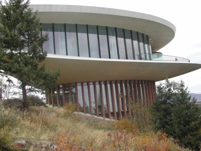
Photograph of Sculptured House
Photograph by Elizabeth, CC BY 2.0. Via Wikimedia Commons.

Deaton Sculptured House

Built in 1963 (expressionist architecture). Listed on the National Register of Historic Places in 2004.

From the record

“The Sculptured House, also known as the Sleeper House, is a distinctive elliptical curved house built in Genesee, Colorado, United States, on Genesee Mountain in 1963 by the architect Charles Deaton. It features prominently in the 1973 Woody Allen sci-fi comedy Sleeper.”

Wikipedia article Sculptured House, CC BY-SA 4.0.

One of 83 National Register listings published here for Jefferson County · listed in 2004 · category: Building · built in 1963, expressionist architecture, by Charles Deaton.

Sources: the Wikipedia article · the case file at the National Archives · the National Register database, National Park Service

The listing

  • Address. 24501 Ski Hill Dr., Golden, 80401
  • When was it listed? February 2004
  • Category. building
  • Census division. Golden
  • When was it built? 1963
  • Architectural style. expressionist architecture
  • Architect. Charles Deaton
  • National Register reference number. 02000385 - the number the National Park Service assigned this property when it was listed, and the key its nomination file is catalogued under at the National Archives.

Fires near this property

243 since 2003

Regional context, not property-specific evidence. The federal wildfire occurrence database lists 243 fires within 5 miles of Deaton Sculptured House between 2003 and 2020, burning about 1,718 acres in total. 10 started naturally. 1 was recorded as arson. Distance is straight-line from the map coordinates, so a fire counted here may appear on a neighbouring settlement's page as well.

Reported cause Fires
Missing data/not specified/undetermined197
Smoking14
Equipment and vehicle use10
Natural10
Recreation and ceremony4
Fireworks3
Misuse of fire by a minor2
Debris and open burning1
Arson/incendiarism1
Railroad operations and maintenance1

The most recent of them, most recent first, with the day each was reported and the service that recorded it.

DateCause SizeReported by Name on the report
9 September 2015Missing data/not specified/undeterminedunder an acreWest Metro Fire RescueUNKNOWN
8 September 2019Naturalunder an acreColorado State Forest Service-State Headquartersnot named
8 September 2019Naturalunder an acreColorado State Forest Service-State HeadquartersN/A
7 September 2013Missing data/not specified/undeterminedunder an acreGolden Fire DepartmentUNKNOWN
6 September 2011Missing data/not specified/undeterminedunder an acreColorado State Forest Service-State HeadquartersGOLDEN
5 September 2019Missing data/not specified/undeterminedunder an acreColorado State Forest Service-State Headquartersnot named
5 September 2015Missing data/not specified/undetermined1.0 acresWest Metro Fire RescueUNKNOWN
4 September 2018Missing data/not specified/undeterminedunder an acreGolden Fire DepartmentUNKNOWN

Every fire recorded in Jefferson County

Mines and quarries near this property

10 of 108 shown

Regional context, not property-specific evidence. The federal mineral resources record lists 108 workings within 5 miles of Deaton Sculptured House: 53 producers, 31 occurrences, 20 past producers, 3 unknowns. 53 still produce. What was taken out: Clay, Fire Clay (Refractory), Uranium, Sand and Gravel, Construction. Distance is straight-line from the map coordinates, so a quarry counted here may appear on a neighbouring settlement's page as well.

Where SiteCommodity StatusRecorded
Alumet Pilot PlantAluminumUnknown
Bear CreekGypsum-AnhydriteProducer
Buckman PropertyUranium, Copper, Lead, Molybdenum, Zinc, SilverOccurrenceVein
Burroughs Feldspar MineFeldspar, Beryllium, Mica, Niobium (Columbium), Tantalum, Bismuth, REE, Uranium, Thorium, LithiumPast Producer1942, 1944
Capitol CentralLead, Gold, Silver, ZincUnknown
FoothillsGold, SilverPast Producer
Genessee Mountain Scheelite OccurrenceTungstenOccurrenceScheelite
Grapevine MineUranium, VanadiumPast Producer1955
Malachite MineGold, Copper, Silver, Zinc, Nickel, LeadPast Producer1866, 1888
Roscoe Beryl ProspectMica, Feldspar, Quartz, REE, BerylliumPast ProducerBeryl, Gadolinite, Monazite, Muscovite, Xenotime

Every working recorded in Jefferson County

Storms near this property

60 of 70 shown

Regional context, not property-specific evidence. The National Weather Service names Golden, the town this property stands in, in 70 storm reports between 1994 and 2025: 53 hail, 7 flash flood, 6 lightning, 4 thunderstorm wind. No death or injury is recorded in these reports. Each account below is quoted exactly as the forecast office filed it, from the NOAA Storm Events Database, and each date opens the federal record of that event.

WhenEvent Place namedHarm What the report says
May 2007LightningGolden$200,000no account filed
September 2013Flash FloodGolden-Coal Creek went over its banks and washed out portions of CO72 at Twin Spruce. The highway was completely washed out between Plainview and Twin Spruce. Additional washouts occurred on side streets within Coal Creek Canyon. Many residents were ordered to remain in their homes (Shelter In Place) until rescue teams could reach them.
September 2013Flash FloodGolden-Flash flooding and debris was reportedly washed out a sections of CO72 at the base of Coal Creek Canyon. Road closures included: CO72 , from CO93 to Coal Creek Canyon; CO93, between CO72 and CO128; CO72, between CO93 and Indiana St.; U.S. 36, between Wadsworth Blvd and Flatirons; Interstate 70 west, from Floyd Hill to Hidden Valley due to rock slides. Natural Gas Lines in Coal Creek Canyon were also shut off.
September 2013Flash FloodGolden-Continuous heavy rainfall produced flash flooding. Additional road washouts occurred on side streets within Coal Creek Canyon. CO72 was completely washed out between Plainview and Twin Spruce.
September 2013Flash FloodGolden-Continuous moderate to heavy rainfall produced flash flooding.
September 2013Flash FloodGolden-Continuous heavy rainfall produced widespread flash flooding.
August 2010LightningGolden-A lightning strike sparked a small grass fire near Quaker Street and Golden Road. It was quickly extinguished by emergency responders.
July 2003Flash FloodGolden-Heavy rainfall caused flooding and flash flooding problems in north central Jefferson County. Officials were forced to briefly close State Highway 93, north of Golden, which was flooded by runoff and littered with debris. In Golden, flash floods left several backyards and basements full of standing water. At least one car was submerged in a garage. Radar estimated 1 to 1.5 inches of rain had fallen in the area in approximately 30 minutes.
August 2001LightningGolden-Lightning coupled with strong thunderstorm winds knocked out power to approximately 10,000 Excel Energy customers.
July 2000LightningGolden-Lightning sparked a grassfire that burned approximately 50 acres at the Rocky Flats Environmental Test Facility.
August 2000LightningGolden-Lightning sparked three small grassfires near Golden. The fires however, were quickly contained.
July 1997Flash FloodGolden-Heavy rain caused Lena Gulch to surge 2 feet over its banks. The fire department had to rescue a man when his van stalled in the highwaters.
April 1994HailGolden-Weather spotters reported dime-size hail fell at the intersection of Highways 287 and C470 in Jefferson County. Marble-size hail covered the ground near Golden (12 miles west of Denver), to a depth of one inch.
July 2025Thunderstorm WindGolden-no account filed
August 2021HailGolden-no account filed
August 2020HailGolden-no account filed
July 2019HailGolden-no account filed
May 2017HailGolden-no account filed
July 2016HailGolden-no account filed
May 2015HailGolden-no account filed
June 2015HailGolden-no account filed
July 2014HailGolden-no account filed
August 2014HailGolden-no account filed
March 2014Thunderstorm WindGolden-no account filed
August 2011HailGolden-no account filed
June 2010HailGolden-no account filed
July 2010HailGolden-no account filed
July 2009HailGolden-no account filed
September 2009HailGolden-no account filed
May 2008HailGolden-no account filed
May 2007HailGolden-no account filed
July 2007HailGolden-no account filed
May 2007HailGolden-no account filed
July 2007HailGolden-no account filed
April 2006HailGolden-no account filed
April 2005HailGolden-no account filed
March 2005LightningGolden-no account filed
April 2005HailGolden-no account filed
June 2005Thunderstorm WindGolden-no account filed
June 2004HailGolden-no account filed
June 2003HailGolden-no account filed
August 2002HailGolden-no account filed

Every storm recorded in Jefferson County

Map coverage status

No historic map-sheet match is published for this property yet. That does not mean no map exists. This record needs a coordinate-quality review before it can be joined to a sheet boundary. Browse the county's mapped places while that work is pending.

Listed places nearby

6 within 8 miles

Other National Register properties close enough to walk or drive between, ordered by distance from this one. Both positions come from the same geocoding pass that matched these properties to their map sheets.

Photograph PropertyDistance Listed
Rockland Community Church and Cemetery0.7 miles2009
Katherine Craig Park0.9 miles1995
Thiede Ranch1.5 miles1996
Genesee Park2.1 miles1990
Lorraine Lodge2.4 miles1984
Queen of Heaven Orphanage Summer Camp2.6 miles2000

Sources for this property

National Archives recordThe nomination case file for reference 02000385 in Record Group 79.
Wikipedia articleCommunity-written account of this property, licensed CC BY-SA.
Jefferson CountyAll 83 listed properties in this county.

Provenance

  • Listing record. National Park Service National Register of Historic Places, listed-properties dataset, current to 2026-05-22.
  • Map join. Address geocoded through the United States Census geocoder, then tested against the published boundary of every sheet in the USGS Historical Topographic Map Collection.
  • How this page is made. Listing fields come from federal records; map-sheet coverage is a labelled coordinate-to-boundary calculation, not a source-field claim.
  • Wildfire. Short, Karen C. 2022. Spatial wildfire occurrence data for the United States, 1992-2020 [FPA_FOD_20221014]. 6th Edition. Fort Collins, CO: Forest Service Research Data Archive. https://doi.org/10.2737/RDS-2013-0009.6 Collected with United States Government funding and usable without additional permissions or fees.
  • Mines and quarries. USGS Mineral Resources Data System (MRDS) https://mrdata.usgs.gov/mrds/ A work of the United States government, no copyright under 17 U.S.C. 105.
  • Storms. NOAA National Centers for Environmental Information, Storm Events Database https://www.ncei.noaa.gov/stormevents/ A work of the United States government, no copyright under 17 U.S.C. 105. Narratives are quoted verbatim from the National Weather Service report and are not edited or summarised.