 Block
From the record
One of 28 National Register listings published here for Montrose County · listed in 2003 · category: Building · built in 1910.
Sources: the case file at the National Archives · the National Register database, National Park Service
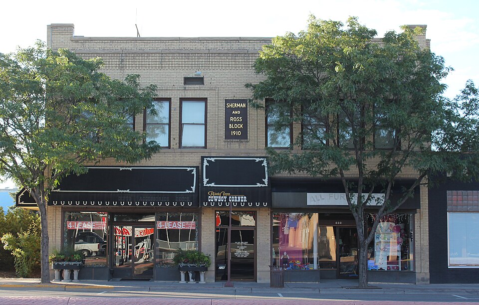
Built in 1910. Listed on the National Register of Historic Places in 2003.
One of 28 National Register listings published here for Montrose County · listed in 2003 · category: Building · built in 1910.
Sources: the case file at the National Archives · the National Register database, National Park Service
Regional context, not property-specific evidence. The federal wildfire occurrence database lists 485 fires within 5 miles of Sherman and Ross Block Building between 1993 and 2020, burning about 812 acres in total. 9 started naturally. 7 were recorded as arson. Distance is straight-line from the map coordinates, so a fire counted here may appear on a neighbouring settlement's page as well.
| Reported cause | Fires |
|---|---|
| Missing data/not specified/undetermined | 346 |
| Debris and open burning | 41 |
| Smoking | 32 |
| Equipment and vehicle use | 25 |
| Recreation and ceremony | 17 |
| Natural | 9 |
| Arson/incendiarism | 7 |
| Fireworks | 4 |
| Misuse of fire by a minor | 2 |
| Railroad operations and maintenance | 1 |
| Power generation/transmission/distribution | 1 |
The most recent of them, most recent first, with the day each was reported and the service that recorded it.
| Date | Cause | Size | Reported by | Name on the report |
|---|---|---|---|---|
| 9 September 2018 | Missing data/not specified/undetermined | under an acre | Montrose Fire Protection District | UNKNOWN |
| 9 September 2016 | Missing data/not specified/undetermined | under an acre | Montrose Fire Protection District | UNKNOWN |
| 7 September 2019 | Debris and open burning | under an acre | Colorado State Forest Service-State Headquarters | not named |
| 7 September 2019 | Missing data/not specified/undetermined | under an acre | Colorado State Forest Service-State Headquarters | not named |
| 7 September 2018 | Smoking | under an acre | Montrose Fire Protection District | UNKNOWN |
| 5 September 2017 | Missing data/not specified/undetermined | under an acre | Montrose Fire Protection District | UNKNOWN |
| 5 September 1993 | Recreation and ceremony | under an acre | Montrose Fire Protection District | not named |
| 3 September 2017 | Missing data/not specified/undetermined | under an acre | Montrose Fire Protection District | UNKNOWN |
Regional context, not property-specific evidence. The federal mineral resources record lists 26 workings within 5 miles of Sherman and Ross Block Building: 11 unknowns, 7 occurrences, 7 past producers, 1 producer. 1 still produces. What was taken out: Sand and Gravel, Construction, Gold, Clay, Lead, Zinc, Copper. Distance is straight-line from the map coordinates, so a quarry counted here may appear on a neighbouring settlement's page as well.
| Where | Site | Commodity | Status | Recorded |
|---|---|---|---|---|
| Clay Pit | Clay | Unknown | ||
| Poughkeepsie Mill | Lead, Zinc, Copper | Past Producer | ||
| Dolores Placer | Gold | Past Producer | ||
| Good Bye Dan | Gold | Past Producer | ||
| Placer | Gold | Past Producer | ||
| Red Canon | Gold | Past Producer | ||
| Corey Gravel Pit | Sand and Gravel, Construction | Past Producer | ||
| Gravel Pit | Sand and Gravel, Construction | Unknown | ||
| Gravel Pit | Sand and Gravel, Construction | Unknown | ||
| Gravel Pit | Sand and Gravel, Construction | Unknown |
Regional context, not property-specific evidence. The National Weather Service names Montrose, the town this property stands in, in 30 storm reports between 1994 and 2024: 7 thunderstorm wind, 5 funnel cloud, 5 flood, 4 flash flood. The reports record 1 death. Each account below is quoted exactly as the forecast office filed it, from the NOAA Storm Events Database, and each date opens the federal record of that event.
| When | Event | Place named | Harm | What the report says |
|---|---|---|---|---|
| May 2004 | Lightning | Montrose | 1 killed | no account filed |
| June 2024 | Lightning | Montrose | $500,000 | One of several strong to severe thunderstorms that passed through the city of Montrose produced a bolt of lightning that struck a house south of town. This then set the house on fire, eventually destroying it. |
| June 2009 | Thunderstorm Wind | Montrose | $20,000 | A microburst traversed a section of the town of Montrose, breaking off numerous large branches and snapping off some trees. Loose objects such as picnic tables, chairs, and barbecue grills were blown over or tossed around. It took three days for the City of Montrose to clean up all of the debris on sidewalks and streets. |
| July 2006 | Flash Flood | Montrose | $20,000 | no account filed |
| August 2010 | Flash Flood | Montrose | $10,000 | A ten foot high and 30 foot wide wall of water came roaring down normally dry Tappan Wash and went out of its banks in places, including yards of residences as well as a section of Dave Wood Road. A person hiking up the wash narrowly escaped the wall of water by quickly climbing up the wash embankment. Culverts and irrigation canals were clogged with debris which included logs and a large amount of personal property. Some of the personal property items were later found downstream. A camper trailer in a yard was knocked over and damaged by the flood waters, while a nearby trailer was picked up and carried a short distance away. |
| June 2004 | Thunderstorm Wind | Montrose | $10,000 | no account filed |
| July 1999 | Flash Flood | Montrose | $10,000 | no account filed |
| July 2022 | Flood | Montrose | $5,000 | The culverts backed up as a result of heavy rain from thunderstorms. This resulted in several inches of water and some embedded debris spilling over onto Racine and Sunshine Roads in Montrose. |
| May 1994 | Thunderstorm Wind | Montrose | $5,000 | Severe thunderstorms rumbled across portions of western and northwestern Colorado. The winds toppled a trailer home north of Montrose and blew over a shed in Rangely (61 miles north of Grand Junction). |
| July 1994 | Thunderstorm Wind | Montrose | $5,000 | Thunderstorm winds toppled several trees Montrose. One tree fell onto a residence, causing damage. |
| April 2023 | Flood | Montrose | $4,000 | Rapid snowmelt resulted in portions of Dave Wood Road to be washed out from flooding. |
| April 2023 | Flood | Montrose | $2,000 | As a result of rapid snowmelt, a portion of Spring Canyon Road in Montrose County was closed due to flooding. |
| August 2009 | Lightning | Montrose | $1,000 | Lightning struck a power substation on the north side of Montrose during the early morning hours, causing minor damage This caused the electrical power to be down for nearly 1400 residences in northern Montrose County north of the town of Montrose for about 90 minutes. |
| August 2022 | Flood | Montrose | - | Localized flooding occurred 6 miles southwest of Montrose as a result of heavy rain from thunderstorms. 1.25 inches of rain fell in an hour. |
| July 2019 | Thunderstorm Wind | Montrose | - | Collapsing thunderstorms brought strong wind gusts estimated at 55 to 65 mph to Montrose resulting in trees being blown over and damage to a car in town. |
| July 2019 | Flood | Montrose | - | Thunderstorms produced heavy rain over the city of Montrose which resulted in some minor street flooding above the crown of the road on North 5th Street. Radar estimated rainfall rates of 0.25 to 0.50 inches per hour. |
| July 2017 | Heavy Rain | Montrose | - | WA total of 0.85 of an inch of rain fell within 30 minutes. |
| May 2009 | Funnel Cloud | Montrose | - | Numerous eyewitnesses, including a local TV station reporter, observed and photographed a funnel cloud north of Montrose. |
| July 2007 | Flash Flood | Montrose | - | Heavy rain producing thunderstorms caused a flash flood which deposited mud, rocks, and debris up to 2 feet deep onto a 30 foot wide section of 175 Road at the bottom of the East Portal near Crystal Dam. |
| July 2006 | Heavy Rain | Montrose | - | no account filed |
| July 2006 | Heavy Rain | Montrose | - | no account filed |
| May 2005 | Thunderstorm Wind | Montrose | - | no account filed |
| August 2005 | Hail | Montrose | - | no account filed |
| October 2004 | Funnel Cloud | Montrose | - | no account filed |
| July 2004 | Thunderstorm Wind | Montrose | - | no account filed |
| July 2004 | Funnel Cloud | Montrose | - | no account filed |
| September 2003 | Heavy Rain | Montrose | - | no account filed |
| August 2000 | Hail | Montrose | - | no account filed |
| April 1998 | Funnel Cloud | Montrose | - | no account filed |
| September 1997 | Funnel Cloud | Montrose | - | no account filed |
No historic map-sheet match is published for this property yet. That does not mean no map exists. This record needs a coordinate-quality review before it can be joined to a sheet boundary. Browse the county's mapped places while that work is pending.
Other National Register properties close enough to walk or drive between, ordered by distance from this one. Both positions come from the same geocoding pass that matched these properties to their map sheets.
| Photograph | Property | Distance | Listed |
|---|---|---|---|
 | US Post Office-Montrose Main | under 500 feet | 1986 |
 | Montrose County Courthouse | 0.1 miles | 1994 |
 | Denver and Rio Grande Depot | 0.1 miles | 1982 |
| Knights of Pythias (KP) Building | 0.1 miles | 2024 | |
 | Benevolent and Protective Order of Elks Lodge | 0.1 miles | 2004 |
 | Montrose City Hall | 0.2 miles | 1982 |
| National Archives record | The nomination case file for reference 03000196 in Record Group 79. |
| Montrose County | All 28 listed properties in this county. |