
BlockBefore
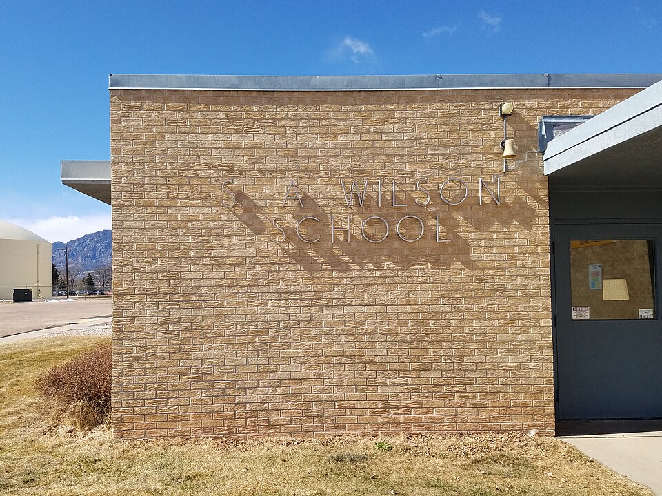
Photograph of S. A. Wilson Elementary School
Photograph by HikingUniversity, CC BY-SA 4.0. Via Wikimedia Commons.

S.A. Wilson Elementary School

Listed on the National Register of Historic Places in 2017.

From the record

“Wilson Elementary School in Security-Widefield, an unincorporated area south of Colorado Springs, Colorado, was built in 1959 and expanded in 1961. It was listed on the National Register of Historic Places in 2017.”

Wikipedia article S.A. Wilson Elementary School, CC BY-SA 4.0.

One of 98 National Register listings published here for El Paso County · listed in 2017 · category: Building.

Sources: the Wikipedia article · the National Register database, National Park Service

The listing

  • What is counted as historic. The nomination lists 1 building as contributing to the listing.
  • Listed as. Wilson, S.A., Elementary School - the National Register files a house under its owner's surname.
  • Address. 930 Lea Dr., Colorado Springs, 80010
  • When was it listed? May 2017
  • Category. building
  • Also known as. Colorado's Mid Century Schools, 1945-1970 MPS
  • National Register reference number. 100000929 - assigned by the National Park Service when the property was listed.

Storms near this property

19 since 1993

Regional context, not property-specific evidence. The National Weather Service names Colorado Springs, the town this property stands in, in 19 storm reports between 1993 and 1996: 16 hail, 2 thunderstorm wind, 1 tornado. No death or injury is recorded in these reports. Each account below is quoted exactly as the forecast office filed it, from the NOAA Storm Events Database, and each date opens the federal record of that event.

WhenEvent Place namedHarm What the report says
August 1993HailColorado Springs$50,000no account filed
August 1993HailColorado Springs$5,000no account filed
August 1995Tornado (F0)Colorado Springs-A tornado briefly touched down twice just southeast of the downtown Colorado Springs, first near the intersection of Hancock and Las Animas and then at the Fountain View Apartments, at the intersection of Hutchinson Drive and Fountain Blvd. Several windows were shattered in the apartment complex, and a 30-foot maple tree was toppled, cutting power lines to the apartment complex and damaging a nearby automobile.
June 1995HailColorado Springs-Very heavy rain accompanied the dime-size hail. The slow moving storm dropped up to three inch rainfall amounts at some locations. A few areas measured rainfall rates of over one inch in 20 minutes.
July 1995Thunderstorm WindColorado Springs-Lightning triggered a minor housefire in the attic. Thunderstorm winds snapped numerous tree limbs which damaged parked cars. In addition, larger branches blocked rush hour traffic along some roads.
May 1994HailColorado Springs-Severe thunderstorms rumbled across El Paso County, dumping hail over much of the area. A spotter reported golf-ball size hail fell in Calhan (32 miles northeast of Colorado Springs).
September 1994HailColorado Springs-,,,,,,,,Flash Flooding Thunderstorms containing hail up to 1 inch in diameter and very heavy rains moved over most of the city of Colorado Springs. Rain fell at the rate of four inches per half hour in isolated locations across the city. Hail accumulated to 6 to 9 inches deep near Garden of the Gods west of Colorado Springs. Snow plows were called out at several locations to remove accumulated hail. Four to five feet of water on one city street stranded six people in their cars who needed to be rescued. Water at Templeton Gap Floodway was 10 to 15 feet deep and 100 feet wide. 100 people were evacuated from Campers Village Mobile Home Park, where water rose rapidly to a depth of four feet.
May 1994HailColorado Springs-Severe thunderstorms rumbled across El Paso County, dumping hail over much of the area. A spotter reported golf-ball size hail fell in Calhan (32 miles northeast of Colorado Springs).
May 1996HailColorado Springs-no account filed
August 1995HailColorado Springs-no account filed
July 1995HailColorado Springs-no account filed
May 1995HailColorado Springs-no account filed
June 1994HailColorado Springs-no account filed
July 1994HailColorado Springs-no account filed
August 1993Thunderstorm WindColorado Springs-no account filed
August 1993HailColorado Springs-no account filed

Every storm recorded in El Paso County

Map coverage status

No historic map-sheet match is published for this property yet. That does not mean no map exists. This record needs a coordinate-quality review before it can be joined to a sheet boundary. Browse the county's mapped places while that work is pending.

Sources for this property

National Archives recordThe nomination case file for reference 100000929 in Record Group 79.
Wikipedia articleCommunity-written account of this property, licensed CC BY-SA.
El Paso CountyAll 98 listed properties in this county.

Provenance

  • Listing record. National Park Service National Register of Historic Places, listed-properties dataset, current to 2026-05-22.
  • Map join. Address geocoded through the United States Census geocoder, then tested against the published boundary of every sheet in the USGS Historical Topographic Map Collection.
  • How this page is made. Listing fields come from federal records; map-sheet coverage is a labelled coordinate-to-boundary calculation, not a source-field claim.
  • Storms. NOAA National Centers for Environmental Information, Storm Events Database https://www.ncei.noaa.gov/stormevents/ A work of the United States government, no copyright under 17 U.S.C. 105. Narratives are quoted verbatim from the National Weather Service report and are not edited or summarised.