 Block
From the record
One of 6 National Register listings published here for San Juan County · listed in 2020 · category: Building.
Sources: the National Register database, National Park Service
Listed on the National Register of Historic Places in 2020.
One of 6 National Register listings published here for San Juan County · listed in 2020 · category: Building.
Sources: the National Register database, National Park Service
Regional context, not property-specific evidence. The federal wildfire occurrence database lists 1 fire within 5 miles of Frisco-Bagley Mine and Tunnel in 2015, burning under an acre in total. None started naturally. None was recorded as arson. Distance is straight-line from the map coordinates, so a fire counted here may appear on a neighbouring settlement's page as well.
| Reported cause | Fires |
|---|---|
| Recreation and ceremony | 1 |
The most recent of them, most recent first, with the day each was reported and the service that recorded it.
| Date | Cause | Size | Reported by | Name on the report |
|---|---|---|---|---|
| 26 September 2015 | Recreation and ceremony | under an acre | Southwest District, Montrose | PALMETTO |
Regional context, not property-specific evidence. The federal mineral resources record lists 338 workings within 5 miles of Frisco-Bagley Mine and Tunnel: 167 past producers, 65 occurrences, 53 unknowns, 51 producers. 52 still produce. What was taken out: Gold, Silver, Lead, Zinc. Distance is straight-line from the map coordinates, so a quarry counted here may appear on a neighbouring settlement's page as well.
| Where | Site | Commodity | Status | Recorded |
|---|---|---|---|---|
| Acapulca | Bismuth, Lead, Silver, Zinc, Gold | Past Producer | ||
| Alabama | Silver, Gold, Lead, Zinc | Past Producer | ||
| American Flats-Eng. Mtn. Dist. | Gold, Lead, Copper, Zinc, Silver | Producer | ||
| Belcher Tun No.1 | Lead, Silver, Zinc, Gold | Past Producer | ||
| Ben Butler | Silver, Gold, Copper, Lead | Past Producer | ||
| Bill Young Group | Silver, Zinc, Gold, Lead | Past Producer | ||
| Black Diamond | Lead, Silver, Copper | Occurrence | Tetrahedrite | |
| Bon Homme Tunnel | Copper, Silver, Lead, Bismuth, Zinc | Past Producer | 1885, 1974 | |
| Bonanza King | Silver, Gold, Copper | Producer | Chalcopyrite, Galena, Sphalerite | |
| Dewitt | Zinc, Silver, Copper, Lead | Producer |
Regional context, not property-specific evidence. The National Weather Service names Silverton, the town this property stands in, in 6 storm reports between 1996 and 2021: 4 flash flood, 1 lightning, 1 debris flow. The reports record 4 injuries. Each account below is quoted exactly as the forecast office filed it, from the NOAA Storm Events Database, and each date opens the federal record of that event.
| When | Event | Place named | Harm | What the report says |
|---|---|---|---|---|
| August 1996 | Lightning | Silverton | 4 hurt | no account filed |
| August 1999 | Flash Flood | Silverton | $10,000 | no account filed |
| July 2007 | Flash Flood | Silverton | $5,000 | Heavy convective rainfall concentrated just north of the La Plata and San Juan County line produced a massive flow of water, rock, and mud which traveled across the Durango to Silverton Narrow Gage Railroad track and dammed up the Animas River about one mile north of Needleton. Initially, the entire river channel was dammed. The river bed at that location was raised 8 feet on the east side of the channel and remained blocked on the west side of the channel. The debris flow covered about 250 feet of railroad track. The peak depth of debris on the railroad track was measured at close to 45 feet. The railroad track did not sustain significant damage, because the lowest several feet of debris on the track consisted primarily of mud. On top of the mud was a lot of rock material with some trees mixed in it. |
| August 1999 | Flash Flood | Silverton | $2,000 | no account filed |
| July 2021 | Debris Flow | Silverton | - | A debris flow occurred as a result of heavy rain over Ophir Pass in the Southwest San Juan Mountains. Social media footage showed a combination of rock and mud across the pass with cars having to turn around as a result of the debris flow. |
| July 1999 | Flash Flood | Silverton | - | no account filed |
No historic map-sheet match is published for this property yet. That does not mean no map exists. This record needs a coordinate-quality review before it can be joined to a sheet boundary. Browse the county's mapped places while that work is pending.
Other National Register properties close enough to walk or drive between, ordered by distance from this one. Both positions come from the same geocoding pass that matched these properties to their map sheets.
| Photograph | Property | Distance | Listed |
|---|---|---|---|
| Martin Mining Complex | 3.3 miles | 2004 | |
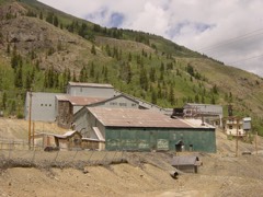 | Shenandoah-Dives Mill | 7.6 miles | 2000 |
| National Archives record | The nomination case file for reference 100005235 in Record Group 79. |
| San Juan County | All 6 listed properties in this county. |