BlockBefore
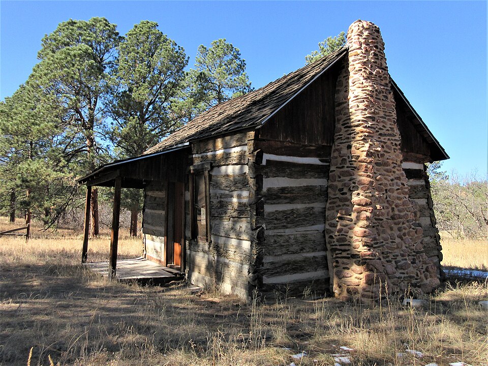
Photograph of Pioneer Cabin
Photograph by Leonard L. Myers, CC BY-SA 4.0. Via Wikimedia Commons.

Pioneer Cabin

Listed on the National Register of Historic Places in 1975.

From the record

“Burgess House, is one of the oldest buildings in Colorado Springs, Colorado's Douglas Valley. It is on the National Register of Historic Places.”

Wikipedia article Pioneer Cabin (Colorado Springs, Colorado), CC BY-SA 4.0.

One of 98 National Register listings published here for El Paso County · listed in 1975 · category: Building.

Sources: the Wikipedia article · the case file at the National Archives · the National Register database, National Park Service · the Wikipedia article

The listing

Fires near this property

214 since 1992

Regional context, not property-specific evidence. The federal wildfire occurrence database lists 214 fires within 5 miles of Pioneer Cabin between 1992 and 2020, burning about 133 acres in total. 19 started naturally. 4 were recorded as arson. Distance is straight-line from the map coordinates, so a fire counted here may appear on a neighbouring settlement's page as well.

Reported cause Fires
Missing data/not specified/undetermined153
Natural19
Smoking15
Equipment and vehicle use8
Debris and open burning6
Recreation and ceremony6
Arson/incendiarism4
Fireworks2
Misuse of fire by a minor1

The most recent of them, most recent first, with the day each was reported and the service that recorded it.

DateCause SizeReported by Name on the report
8 September 2018Smokingunder an acreColorado Springs Fire DepartmentUNKNOWN
4 September 2001Naturalunder an acrePike and San Isabel National ForestGOAT
30 September 2016Missing data/not specified/undeterminedunder an acrePike and San Isabel National ForestDEAD MAN
29 September 2019Missing data/not specified/undeterminedunder an acreColorado State Forest Service-State Headquartersnot named
26 September 2018Missing data/not specified/undeterminedunder an acreColorado Springs Fire DepartmentUNKNOWN
25 September 2014Smokingunder an acreColorado Springs Fire DepartmentUNKNOWN
25 September 2014Missing data/not specified/undeterminedunder an acreColorado Springs Fire DepartmentUNKNOWN
25 September 2005Missing data/not specified/undetermined1.0 acresColorado State Forest Service-State Headquartersnot named

Every fire recorded in El Paso County

Mines and quarries near this property

10 of 24 shown

Regional context, not property-specific evidence. The federal mineral resources record lists 24 workings within 5 miles of Pioneer Cabin: 19 producers, 3 past producers, 2 occurrences. 19 still produce. What was taken out: Sand and Gravel, Construction, Clay, Stone, Crushed/Broken, Magnesite, Limestone, Crushed/Broken, Stone, Crushed/Broken. Distance is straight-line from the map coordinates, so a quarry counted here may appear on a neighbouring settlement's page as well.

Where SiteCommodity StatusRecorded
HollyLimestone, GeneralOccurrenceLimestone
Holly #1 MineStone, Crushed/Broken, MagnesitePast ProducerSedimentary
Holly #1 MineStone, Crushed/Broken, Magnesite, StonePast Producer
Pikeview QuarryLimestone, Crushed/Broken, Stone, Crushed/Broken, MagnesitePast ProducerSedimentary
Hecla-BarberClayProducerClay
Hecla-BarberClayProducer
HustedClayProducerClay
Husted PitClayProducer
Flying W Gravel PitSand and Gravel, ConstructionProducer
Gravel PitSand and Gravel, ConstructionProducer

Every working recorded in El Paso County

Storms near this property

19 since 1993

Regional context, not property-specific evidence. The National Weather Service names Colorado Springs, the town this property stands in, in 19 storm reports between 1993 and 1996: 16 hail, 2 thunderstorm wind, 1 tornado. No death or injury is recorded in these reports. Each account below is quoted exactly as the forecast office filed it, from the NOAA Storm Events Database, and each date opens the federal record of that event.

WhenEvent Place namedHarm What the report says
August 1993HailColorado Springs$50,000no account filed
August 1993HailColorado Springs$5,000no account filed
August 1995Tornado (F0)Colorado Springs-A tornado briefly touched down twice just southeast of the downtown Colorado Springs, first near the intersection of Hancock and Las Animas and then at the Fountain View Apartments, at the intersection of Hutchinson Drive and Fountain Blvd. Several windows were shattered in the apartment complex, and a 30-foot maple tree was toppled, cutting power lines to the apartment complex and damaging a nearby automobile.
June 1995HailColorado Springs-Very heavy rain accompanied the dime-size hail. The slow moving storm dropped up to three inch rainfall amounts at some locations. A few areas measured rainfall rates of over one inch in 20 minutes.
July 1995Thunderstorm WindColorado Springs-Lightning triggered a minor housefire in the attic. Thunderstorm winds snapped numerous tree limbs which damaged parked cars. In addition, larger branches blocked rush hour traffic along some roads.
May 1994HailColorado Springs-Severe thunderstorms rumbled across El Paso County, dumping hail over much of the area. A spotter reported golf-ball size hail fell in Calhan (32 miles northeast of Colorado Springs).
September 1994HailColorado Springs-,,,,,,,,Flash Flooding Thunderstorms containing hail up to 1 inch in diameter and very heavy rains moved over most of the city of Colorado Springs. Rain fell at the rate of four inches per half hour in isolated locations across the city. Hail accumulated to 6 to 9 inches deep near Garden of the Gods west of Colorado Springs. Snow plows were called out at several locations to remove accumulated hail. Four to five feet of water on one city street stranded six people in their cars who needed to be rescued. Water at Templeton Gap Floodway was 10 to 15 feet deep and 100 feet wide. 100 people were evacuated from Campers Village Mobile Home Park, where water rose rapidly to a depth of four feet.
May 1994HailColorado Springs-Severe thunderstorms rumbled across El Paso County, dumping hail over much of the area. A spotter reported golf-ball size hail fell in Calhan (32 miles northeast of Colorado Springs).
May 1996HailColorado Springs-no account filed
August 1995HailColorado Springs-no account filed
July 1995HailColorado Springs-no account filed
May 1995HailColorado Springs-no account filed
June 1994HailColorado Springs-no account filed
July 1994HailColorado Springs-no account filed
August 1993Thunderstorm WindColorado Springs-no account filed
August 1993HailColorado Springs-no account filed

Every storm recorded in El Paso County

Map coverage status

No historic map-sheet match is published for this property yet. That does not mean no map exists. This record needs a coordinate-quality review before it can be joined to a sheet boundary. Browse the county's mapped places while that work is pending.

Listed places nearby

6 within 8 miles

Other National Register properties close enough to walk or drive between, ordered by distance from this one. Both positions come from the same geocoding pass that matched these properties to their map sheets.

Photograph PropertyDistance Listed
Carlton House1.7 miles1989
United States Air Force Academy, Cadet Area2.0 miles2004
Cottonwood Creek Bridge4.9 miles2001
Glen Eyrie7.0 miles1975
Inez Johnson Lewis School7.0 miles1988
Glen Eyrie (Boundary Increase)7.0 miles2016

Sources for this property

National Archives recordThe nomination case file for reference 75000520 in Record Group 79.
Wikipedia articleCommunity-written account of this property, licensed CC BY-SA.
El Paso CountyAll 98 listed properties in this county.

Provenance

  • Listing record. National Park Service National Register of Historic Places, listed-properties dataset, current to 2026-05-22.
  • Map join. Address geocoded through the United States Census geocoder, then tested against the published boundary of every sheet in the USGS Historical Topographic Map Collection.
  • How this page is made. Listing fields come from federal records; map-sheet coverage is a labelled coordinate-to-boundary calculation, not a source-field claim.
  • Wildfire. Short, Karen C. 2022. Spatial wildfire occurrence data for the United States, 1992-2020 [FPA_FOD_20221014]. 6th Edition. Fort Collins, CO: Forest Service Research Data Archive. https://doi.org/10.2737/RDS-2013-0009.6 Collected with United States Government funding and usable without additional permissions or fees.
  • Mines and quarries. USGS Mineral Resources Data System (MRDS) https://mrdata.usgs.gov/mrds/ A work of the United States government, no copyright under 17 U.S.C. 105.
  • Storms. NOAA National Centers for Environmental Information, Storm Events Database https://www.ncei.noaa.gov/stormevents/ A work of the United States government, no copyright under 17 U.S.C. 105. Narratives are quoted verbatim from the National Weather Service report and are not edited or summarised.