 Block
From the record
One of 11 National Register listings published here for Teller County · listed in 1998 · category: District.
Sources: the case file at the National Archives · the National Register database, National Park Service
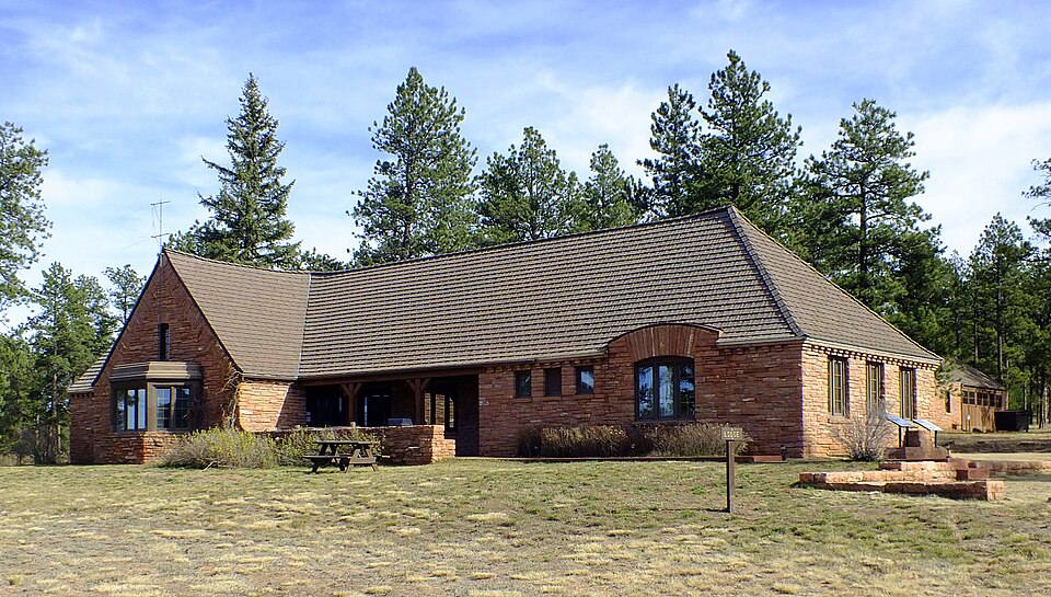
Listed on the National Register of Historic Places in 1998.
One of 11 National Register listings published here for Teller County · listed in 1998 · category: District.
Sources: the case file at the National Archives · the National Register database, National Park Service
Regional context, not property-specific evidence. The federal wildfire occurrence database lists 219 fires within 5 miles of Manitou Experimental Forest Station between 1992 and 2020, burning about 593 acres in total. 67 started naturally. 7 were recorded as arson. Distance is straight-line from the map coordinates, so a fire counted here may appear on a neighbouring settlement's page as well.
| Reported cause | Fires |
|---|---|
| Missing data/not specified/undetermined | 69 |
| Natural | 67 |
| Recreation and ceremony | 52 |
| Firearms and explosives use | 8 |
| Arson/incendiarism | 7 |
| Power generation/transmission/distribution | 4 |
| Debris and open burning | 4 |
| Equipment and vehicle use | 3 |
| Misuse of fire by a minor | 2 |
| Fireworks | 1 |
| Smoking | 1 |
| Other causes | 1 |
The most recent of them, most recent first, with the day each was reported and the service that recorded it.
| Date | Cause | Size | Reported by | Name on the report |
|---|---|---|---|---|
| 25 September 1998 | Recreation and ceremony | under an acre | Pike and San Isabel National Forest | ROASTED PIG |
| 25 September 1992 | Missing data/not specified/undetermined | under an acre | Teller County | not named |
| 23 September 2019 | Missing data/not specified/undetermined | under an acre | Pike and San Isabel National Forest | TURKEY TRACK2 |
| 22 September 2018 | Missing data/not specified/undetermined | 160 acres | Pike and San Isabel National Forest | TURKEY TRACK 8 |
| 21 September 2013 | Missing data/not specified/undetermined | under an acre | Teller County | UNKNOWN |
| 21 September 2003 | Recreation and ceremony | under an acre | Pike and San Isabel National Forest | ROCKY |
| 2 September 2019 | Recreation and ceremony | under an acre | Pike and San Isabel National Forest | 928 |
| 2 September 2019 | Recreation and ceremony | under an acre | Pike and San Isabel National Forest | LOG |
Regional context, not property-specific evidence. The federal mineral resources record lists 25 workings within 5 miles of Manitou Experimental Forest Station: 11 past producers, 9 producers, 5 occurrences. 9 still produce. What was taken out: Feldspar, Gold, Stone, Sand and Gravel, Construction. Distance is straight-line from the map coordinates, so a quarry counted here may appear on a neighbouring settlement's page as well.
| Where | Site | Commodity | Status | Recorded |
|---|---|---|---|---|
| C & S | Fluorine-Fluorite | Past Producer | ||
| Fern Cr. | Quartz, Mica, Fluorine-Fluorite, Feldspar | Producer | Biotite, Fluorite, Quartz | |
| Lone Pine Feldspar Quarry | Feldspar, Niobium (Columbium), Thorium, REE | Past Producer | Microcline | |
| Lone Pine Pegmatite | Niobium (Columbium), Thorium | Occurrence | Pyrochlore, Thorite | |
| Lost Dutchman Quarry | Feldspar, Thorium, REE | Past Producer | 1953 | |
| Snow Flake Mine | REE, Feldspar | Producer | Allanite, Fergusonite, Thalenite, Zircon | |
| Snowflake Mine | Feldspar, Molybdenum, Fluorine-Fluorite, REE, Niobium (Columbium), Tantalum | Past Producer | 1952 | |
| Snowflake Mine | Feldspar, Fluorine-Fluorite, Tantalum | Producer | ||
| Spielman Quarry | Feldspar, REE | Past Producer | 1947 | |
| Brannan Pit No 6 | Sand and Gravel, Construction | Producer |
Regional context, not property-specific evidence. The National Weather Service names Woodland Park, the town this property stands in, in 68 storm reports between 1993 and 2023: 40 hail, 18 flash flood, 3 thunderstorm wind, 3 lightning. The reports record 2 deaths and 2 injuries. Each account below is quoted exactly as the forecast office filed it, from the NOAA Storm Events Database, and each date opens the federal record of that event.
| When | Event | Place named | Harm | What the report says |
|---|---|---|---|---|
| August 1998 | Lightning | Woodland Park | 1 killed, 1 hurt | no account filed |
| July 2006 | Lightning | Woodland Park | 1 killed | A young man playing soccer was struck and killed by lightning. |
| August 2003 | Lightning | Woodland Park | 1 hurt | no account filed |
| July 2004 | Flash Flood | Woodland Park | $500,000 | Rounds of showers and heavy rain from strong thunderstorms caused numerous flash floods...mainly across the Hayman burn scar in the northwest part of the county. Especially hard hit was the road to the Turkey Rock Ranch Estates in far northwest Teller county. Others road affected in the Hayman burn scar were Forest Road 200 and 360 around Lutheran Valley Retreat, and High Road and Shelf Road in the southwest part of the county. Shelf Road was closed for around one month. At least 6 privately owned dams broke, and water flowed over another. A state of emergency was declared by Teller county officials through the weekend. |
| August 2008 | Tornado (EF1) | Woodland Park | $20,000 | A tornado occurred in northeast Teller County...destroying scores of trees...and narrowly missing a subdivision. |
| August 2013 | Flash Flood | Woodland Park | $10,000 | no account filed |
| September 1993 | Hail | Woodland Park | $5,000 | Severe thunderstorms dumped quarter size hail in Woodland Park (20 miles northwest of Colorado Springs). There were reports of marble-size hail 4 inches deep just north of Woodland Park. Several vehicles slid off the roadway due to the hail and sustained minor damage. Snow plows were used to remove the hail from the road. Lightning struck a transformer in Woodland Park, causing a brief power outage. |
| July 2023 | Tornado (EF1) | Woodland Park | - | Maximum wind gust estimated was 108 mph. |
| June 2015 | Flash Flood | Woodland Park | - | Heavy rain caused some flooding of roadways to a depth of greater than six inches. |
| August 2011 | Flash Flood | Woodland Park | - | Six inches or more of water was flowing across State Highway 67 in several spots. |
| July 2010 | Flash Flood | Woodland Park | - | Water over six inches deep flowed across Stump Road. |
| August 2010 | Flash Flood | Woodland Park | - | Up to 3 feet of water flowed in a low water crossing near the intersection of Highway 67 and County Road 78. |
| June 2009 | Thunderstorm Wind | Woodland Park | - | A few pine trees were snapped off. |
| June 2007 | Tornado (EF1) | Woodland Park | - | A slow moving EF1 tornado occurred around 8 miles northwest of Woodland Park around Forest Road 357 (Rule Ridge Road). The tornado lasted around 10 minutes, but only traveled around one mile. The tornado uprooted or snapped off many trees and stranded motorists on the road. No known structures were damaged. |
| July 2006 | Flash Flood | Woodland Park | - | Two to 3 inches of rain fell in a short time west and north of Woodland Park in Teller County, causing Trail Creek Road above Wildhorn Road in northern Teller County to wash out and become completely impassable. Painted Rock Road was only passable on one lane due to flooding. Also...Highway 67 was closed at the Douglas County line due to the flash flooding in Douglas County. |
| August 2004 | Flash Flood | Woodland Park | - | A slow moving thunderstorm brought very heavy rain and flash flooding to Painted Rocks Road. |
| August 2004 | Flash Flood | Woodland Park | - | Very heavy rain from a slow moving thunderstorm brought flash flooding to the southeast portion of the Hayman Burn Scar. |
| May 2003 | Flash Flood | Woodland Park | - | Flooding occurred on Stump Road (Teller County Road 33). |
| May 2003 | Flash Flood | Woodland Park | - | Flooding and road washouts occurred near the four corners area of the Hayman Fire burn scar. |
| July 2003 | Flash Flood | Woodland Park | - | Trail Creek Road was washed out in areas and impassable due to flash flood. |
| July 2002 | Flash Flood | Woodland Park | - | Heavy rain over portions of the Hayman Fire Burn area caused ash and water to rush across roadways in the Turkey Creek Drainage. |
| July 2002 | Flash Flood | Woodland Park | - | Heavy rain forced incident crews in the Hayman Fire Burn area to head for safe spots. Reports of water and debris washing across the roadways were noted. |
| June 1995 | Hail | Woodland Park | - | Large amounts of hail three-quarters inch or smaller fell in the Woodland Park area and north to near the Douglas County line. Small hail was about one-foot deep with drifts to two feet in northeast Teller County. The small eight inches deep in spots near Woodland Park. |
| August 1993 | Hail | Woodland Park | - | Spotters reported hail up to half dollar-size fell in Woodland Park (20 miles northwest of Colorado Springs). |
| September 1993 | Hail | Woodland Park | - | Severe thunderstorms dumped quarter size hail in Woodland Park (20 miles northwest of Colorado Springs). There were reports of marble-size hail 4 inches deep just north of Woodland Park. Several vehicles slid off the roadway due to the hail and sustained minor damage. Snow plows were used to remove the hail from the road. Lightning struck a transformer in Woodland Park, causing a brief power outage. |
| July 2023 | Heavy Rain | Woodland Park | - | no account filed |
| June 2021 | Hail | Woodland Park | - | no account filed |
| June 2021 | Hail | Woodland Park | - | no account filed |
| June 2021 | Hail | Woodland Park | - | no account filed |
| June 2018 | Hail | Woodland Park | - | no account filed |
| May 2018 | Hail | Woodland Park | - | no account filed |
| July 2018 | Hail | Woodland Park | - | no account filed |
| July 2018 | Hail | Woodland Park | - | no account filed |
| July 2018 | Hail | Woodland Park | - | no account filed |
| July 2018 | Hail | Woodland Park | - | no account filed |
| June 2016 | Hail | Woodland Park | - | no account filed |
| June 2014 | Hail | Woodland Park | - | no account filed |
| June 2014 | Hail | Woodland Park | - | no account filed |
| August 2013 | Hail | Woodland Park | - | no account filed |
| July 2010 | Hail | Woodland Park | - | no account filed |
| July 2010 | Hail | Woodland Park | - | no account filed |
| July 2010 | Hail | Woodland Park | - | no account filed |
| July 2010 | Hail | Woodland Park | - | no account filed |
| June 2009 | Hail | Woodland Park | - | no account filed |
| June 2009 | Hail | Woodland Park | - | no account filed |
| July 2009 | Hail | Woodland Park | - | no account filed |
| July 2009 | Hail | Woodland Park | - | no account filed |
| June 2008 | Hail | Woodland Park | - | no account filed |
| July 2008 | Hail | Woodland Park | - | no account filed |
| August 2008 | Hail | Woodland Park | - | no account filed |
| June 2007 | Hail | Woodland Park | - | no account filed |
| June 2006 | Thunderstorm Wind | Woodland Park | - | no account filed |
| June 2006 | Hail | Woodland Park | - | no account filed |
| June 2005 | Hail | Woodland Park | - | no account filed |
| June 2005 | Flash Flood | Woodland Park | - | no account filed |
| July 2004 | Hail | Woodland Park | - | no account filed |
| September 2004 | Hail | Woodland Park | - | no account filed |
| July 2004 | Hail | Woodland Park | - | no account filed |
| July 2003 | Flash Flood | Woodland Park | - | no account filed |
| July 2002 | Flash Flood | Woodland Park | - | no account filed |
No historic map-sheet match is published for this property yet. That does not mean no map exists. This record needs a coordinate-quality review before it can be joined to a sheet boundary. Browse the county's mapped places while that work is pending.
| National Archives record | The nomination case file for reference 98001091 in Record Group 79. |
| Teller County | All 11 listed properties in this county. |