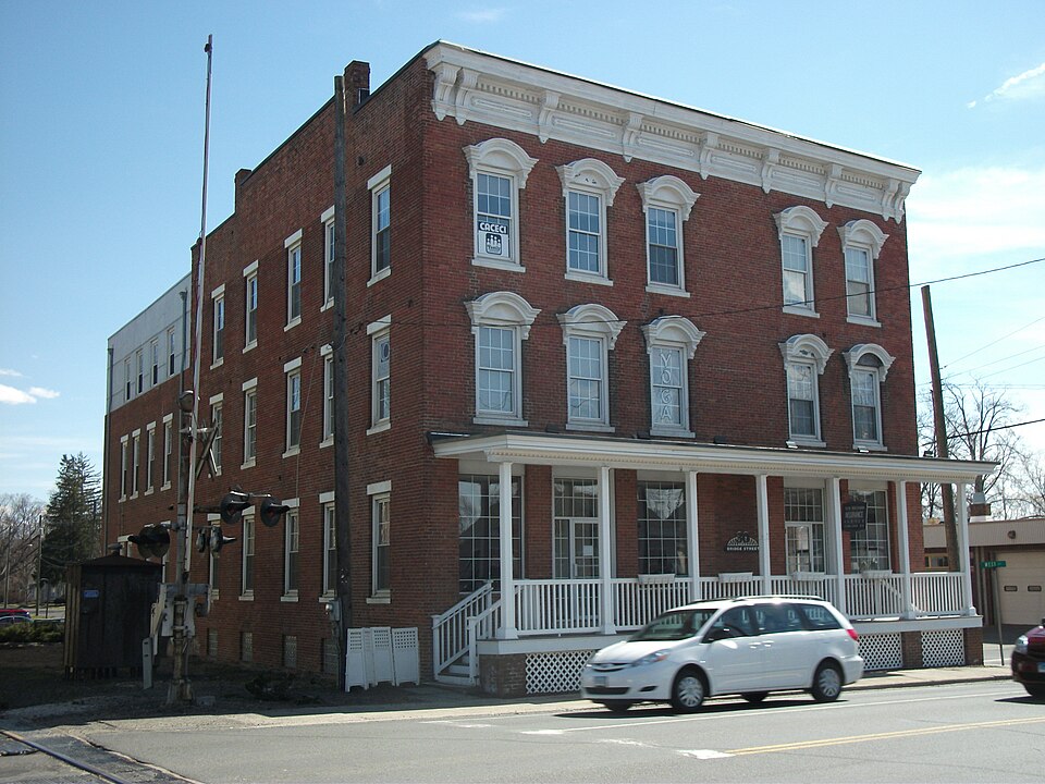
Listed on the National Register of Historic Places in 1992.
From the record
“The Merritt Beach & Son Building is a historic commercial building at 30 Bridge Street U.S. Built in 1873, it is one of the town's oldest surviving commercial buildings.”
Wikipedia article Merritt Beach & Son Building, CC BY-SA 4.0.
One of 166 National Register listings published here for Litchfield County · listed in 1992 · category: Building.
National Register reference number.92000403- the number the National Park Service assigned this property when it was listed, and the key its nomination file is catalogued under at the National Archives.
What happened here
An account from the chapter on New Milford town. The inset identifies its exact
source book and publication year.
Shortly after this we had an exciting chase. We had come up with Early^s troops at Mt. Jackson, where they had established a hospital, and we gave chase after them with our three army corps stretched across the entire valley from mountain to mountain. The valley was undulating, and as we reached a rise of ground we could see Early's troops just going over the next rise, and so it continued all the afternoon, our light artillery driving ahead of the infantry, and throwing solid shot or shell after them kept them moving at a lively pace while the infantry followed.
The Potatucks were a i)owerful tribe, with whom the white settlers never had any difficulty ; but as the neighboring settlement of Woodbury increased in population they longed for some more congenial retreat, and in time most of them joined the clan at New Milford.
When the Weautenaugs of New Milford first became a distinct clan is not known. That they occupied lauds here opposite the village prior to 1671 is quite evident ; but how long before that we have no positive proof. That they were then an insignficant clan is evident from the fact that they were unknown in history and in song, only as the name of the place would indicate some knowledge of the locality by the colonial authorities. Afterwards, however, they became of more importance, probably as early as 1650. At the time of the settlement of New Milford there were probably small clans along the Housatonic River northward, refugees from larger tribes, and, if not making any permanent place their residence, roamed over the vast expanse of wilderness for purposes of hunting and fishing. There was, undoubtedly, quite an extensive clan in the southern part of Berkshire Co., Mass., on the Housatonic River; which had been there many years among those grand old mountains, the natural home of the red man, springing from the Mahikanders or River Indians, who lived on the east side of the Hudson River below Albany. But all these small tribes or clans were very insignifi- cant and weak in comparison witli that large and powerful tribe of Northern New York, the Mohawks, who claimed jurisdiction over all the territory of Western Massachusetts and Connecticut, and came down annually to collect tribute from them, which must be satisfied or a fierce army of blood-thirsty Mohawks would soon appear among them to enforce their demands. They were compelled to pay for fear of death or captivity. The cry, " A Mohawk !" caused all the signal-fires to be lighted on the mountain heights, and drove the peaceful Indians along the Housatonic River into their forts, or to the settlements of the whites for protection. The New Milford Indians had forts on both sides of the Housatonic River, probably in the vicinity of the Steep Rock, about six miles above the village, as appears from an ancient map of Weautenaug, found when the town was first settled. And there was also a fort somewhere in the locality of the residence of E. T. Brewer, from which circumstance the place has always been called "Fort Hill."
Regional context, not property-specific
evidence. The
federal wildfire occurrence database
lists 141 fires within 5 miles of Merritt Beach & Son Building
between 1992 and 2020, burning about 151 acres in total. None started naturally. 10 were recorded as arson.
Distance is straight-line from the map coordinates, so a fire counted
here may appear on a neighbouring settlement's page as well.
Reported cause
Fires
Missing data/not specified/undetermined
67
Debris and open burning
21
Recreation and ceremony
17
Misuse of fire by a minor
11
Arson/incendiarism
10
Railroad operations and maintenance
5
Smoking
4
Equipment and vehicle use
3
Other causes
2
Fireworks
1
The most recent of
them, most recent first, with the day each was reported and the service
that recorded it.
Regional context, not property-specific
evidence. The federal mineral resources record lists
23 workings within 5 miles of Merritt Beach & Son Building: 18 past producers, 4 producers, 1 occurrence.
4 still produce. What was taken out: Sand and Gravel, Construction, Iron, Quartz, Stone. Distance is straight-line from the
map coordinates, so a quarry counted here may appear on a neighbouring
settlement's page as well.
Regional context, not property-specific
evidence. The National Weather Service names
New Milford, the town this property stands in, in 33 storm reports between 1994 and 2019: 17 thunderstorm wind, 7 hail, 5 flash flood, 2 flood.
No death or injury is recorded in these reports. Each account below is quoted exactly as the forecast office
filed it, from the NOAA Storm Events Database, and each date
opens the federal record of that event.
During the afternoon of November 4, a line of showers and embedded thunderstorms crossed western Connecticut. At New Milford in Litchfield County, lightning destroyed the computer system in the public library.
A strong cold front triggered scattered showers and thunderstorms across Litchfield County during the afternoon of July 10. One of the storms became severe. Thunderstorm winds knocked large tree limbs down in the town of New Milford.
Flooding was reported along portions of the East Aspetuck River near New Milford. This flooding resulted in three road closures, including Welles Road and Merryall Road.
Heavy rain and associated runoff caused the Still River at Brookfield to exceed its flood stage of 12.0 feet at 2:11 AM EST Thursday morning on the 9th, crested at 12.32 feet at 6:30 AM EST on the 9th, and fell back below flood stage at 12:51 PM EST.
A weak upper air disturbance produced widely scattered thunderstorms across Litchfield County during the evening of August 26. One of the storms became briefly severe as it deposited dime size hail in the town of New Milford.
State police reported that three-quarter-inch hail covered the ground in New Milford. There were numerous reports of pea-size hail in Litchfield, Hartford, and Tolland Counties.
No historic map-sheet match is published
for this property yet. That does not mean no map exists. This record needs
a coordinate-quality review before it can be joined to a sheet boundary.
Browse the county's mapped places while that work is
pending.
Listed places nearby
6 within 8 miles
Other National Register properties close
enough to walk or drive between, ordered by distance from this one. Both
positions come from the same geocoding pass that matched these properties
to their map sheets.
Listing record. National Park Service National Register of Historic Places, listed-properties dataset, current to 2026-05-22.
Map join. Address geocoded through the United States Census geocoder, then tested against the published boundary of every sheet in the USGS Historical Topographic Map Collection.
How this page is made. Listing fields come from federal records; map-sheet coverage is a labelled coordinate-to-boundary calculation, not a source-field claim.
Wildfire. Short, Karen C. 2022. Spatial wildfire occurrence data for the United States, 1992-2020 [FPA_FOD_20221014]. 6th Edition. Fort Collins, CO: Forest Service Research Data Archive. https://doi.org/10.2737/RDS-2013-0009.6 Collected with United States Government funding and usable without additional permissions or fees.
Mines and quarries. USGS Mineral Resources Data System (MRDS) https://mrdata.usgs.gov/mrds/ A work of the United States government, no copyright under 17 U.S.C. 105.
Storms. NOAA National Centers for Environmental Information, Storm Events Database https://www.ncei.noaa.gov/stormevents/ A work of the United States government, no copyright under 17 U.S.C. 105. Narratives are quoted verbatim from the National Weather Service report and are not edited or summarised.
 Block