 Block
BlockScottsmoor, Florida
13 topographic sheets cover this place, the earliest surveyed in 1950 and the latest in 1979. It stands in the Titusville census division. It lies in ZIP code area 32754. The Survey maps it on the Maytown quadrangle. 692 people lived here at the 2020 count. It stands 30 feet above sea level.
Then and now
1950 to 1979The same ground, surveyed 29 years apart. Drag the handle to wipe between them. Both sheets are United States Geological Survey originals; neither has been altered.
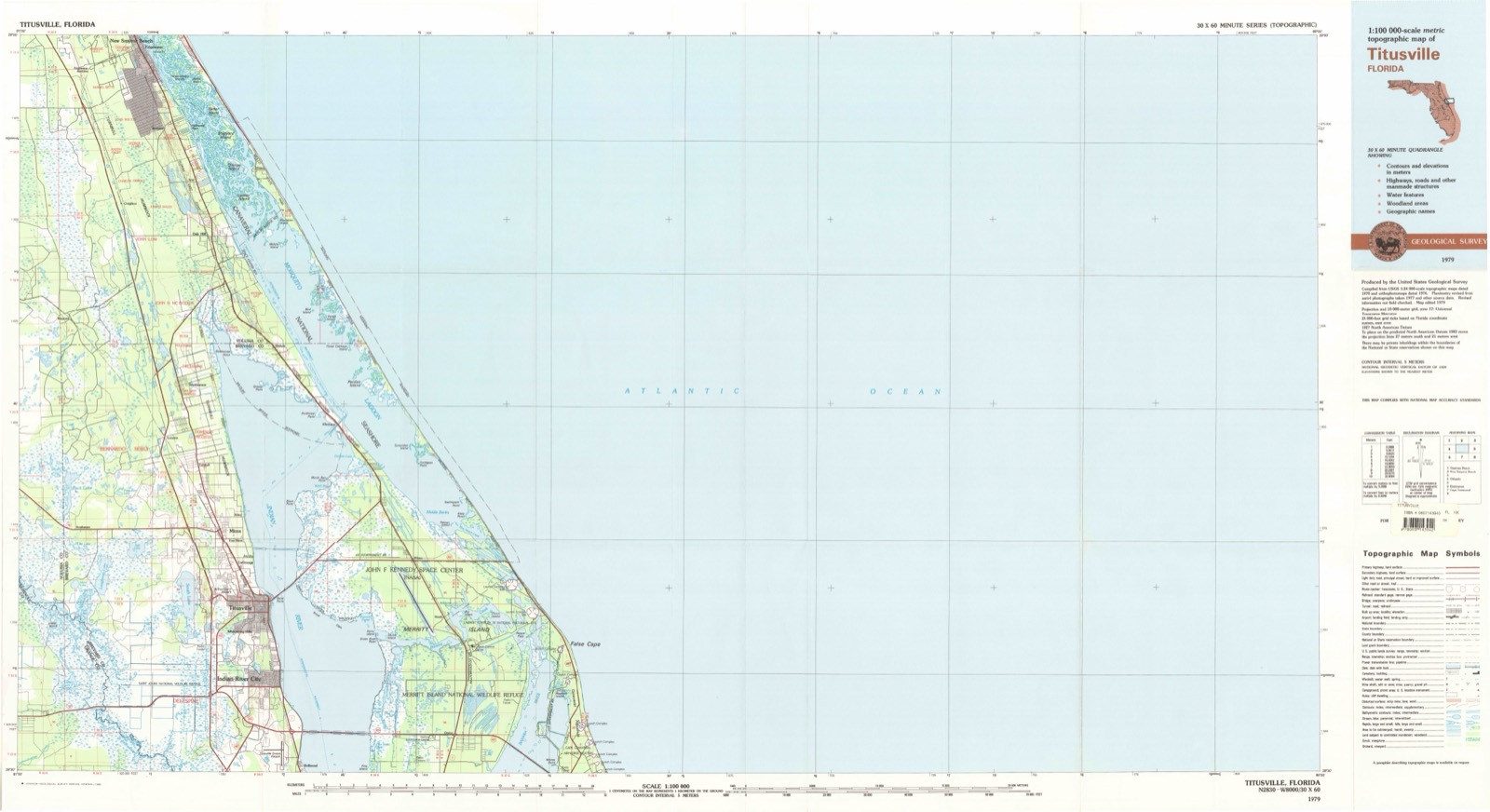
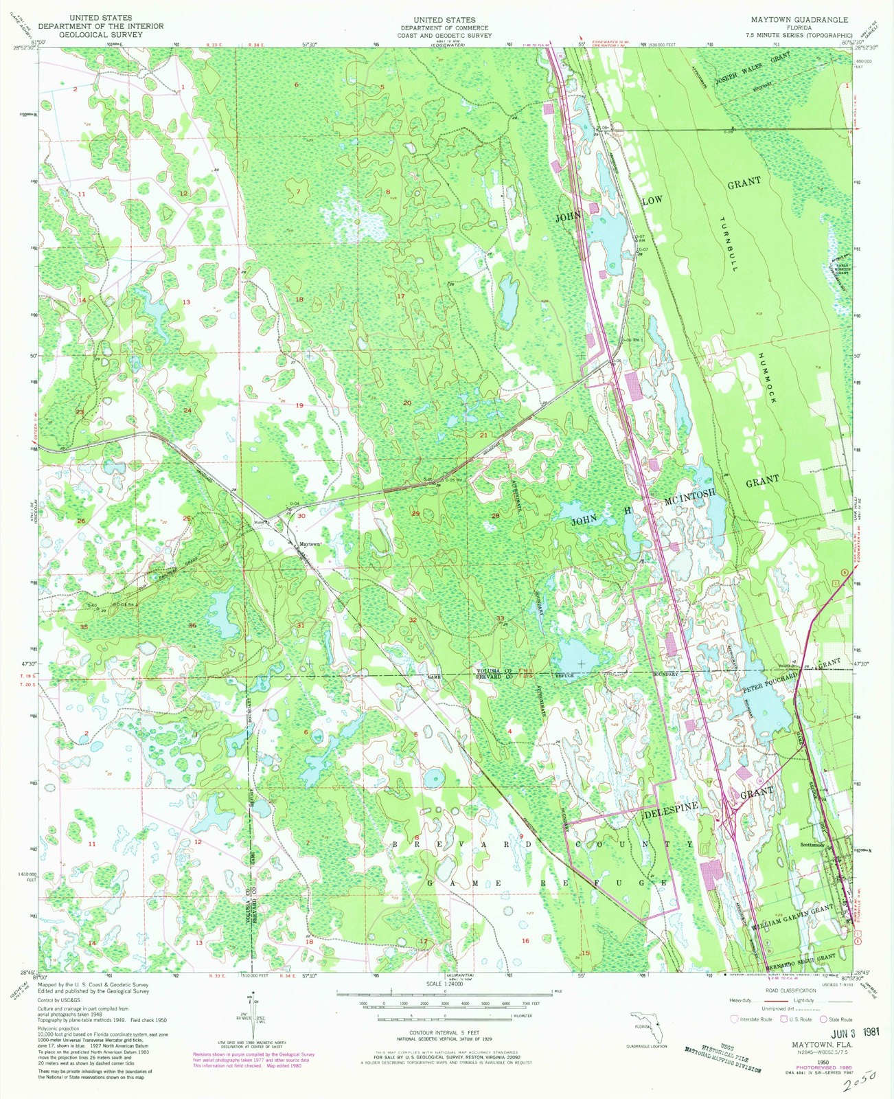
Topographic sheets covering this place
6 surveys from 13 printed sheetsMatched by testing this settlement's coordinate against the published boundary of every sheet in the United States Geological Survey's historical collection. Each opens the scanned sheet at the Survey.
- 1950 USGS Maytown quadrangle1:24000, 6 printings
- 1955 USGS Orlando quadrangle1:250000, 3 printings
- 1957 USGS Orlando quadrangle1:250000
- 1958 USGS Orlando quadrangle1:250000
- 1962 USGS Orlando quadrangle1:250000
- 1979 USGS Titusville quadrangle1:100000
Fires near this place
232 since 1992Regional context, not property-specific evidence. The federal wildfire occurrence database lists 232 fires within 5 miles of Scottsmoor between 1992 and 2020, burning about 7,191 acres in total. 97 started naturally. 26 were recorded as arson. Distance is straight-line from the map coordinates, so a fire counted here may appear on a neighbouring settlement's page as well.
| Reported cause | Fires |
|---|---|
| Natural | 97 |
| Missing data/not specified/undetermined | 44 |
| Equipment and vehicle use | 37 |
| Arson/incendiarism | 26 |
| Debris and open burning | 10 |
| Railroad operations and maintenance | 7 |
| Recreation and ceremony | 5 |
| Power generation/transmission/distribution | 3 |
| Misuse of fire by a minor | 2 |
| Smoking | 1 |
The most recent of them, most recent first, with the day each was reported and the service that recorded it.
| Date | Cause | Size | Reported by | Name on the report |
|---|---|---|---|---|
| 3 September 2013 | Recreation and ceremony | under an acre | Merritt Island National Wildlife Refuge | DITCH FIRE |
| 29 September 2009 | Natural | 4.0 acres | Florida Forest Service | BEST WESTERN (O5) |
| 27 September 2010 | Arson/incendiarism | under an acre | Florida Forest Service | OUTBOARD (O5) |
| 26 September 2018 | Natural | 3.0 acres | Florida Forest Service | BIG TIRE - (05) |
| 26 September 2018 | Natural | 25 acres | Florida Forest Service | HORSESHOE FIRE (05) |
| 26 September 2016 | Natural | 8.0 acres | Florida Forest Service | DEERING (5) |
| 26 September 2010 | Recreation and ceremony | 2.0 acres | Florida Forest Service | CHEECH (05) |
| 22 September 2016 | Missing data/not specified/undetermined | 11 acres | Florida Forest Service | TRAIL (64) |
Settlements close enough to share some of these fires:
Mines and quarries near this place
1 within 5 milesRegional context, not property-specific evidence. The federal mineral resources record lists 1 working within 5 miles of Scottsmoor: 1 producer. All of them still produce. What was taken out: Limestone, General. Distance is straight-line from the map coordinates, so a quarry counted here may appear on a neighbouring settlement's page as well.
| Where | Site | Commodity | Status | Recorded |
|---|---|---|---|---|
| Volusia Co. Rd. and Bridge - Oak Hill Pit | Limestone, General | Producer | Limestone |
Storms near this place
18 since 2001Regional context, not property-specific evidence. The National Weather Service names Scottsmoor in 18 storm reports between 2001 and 2022: 9 hail, 4 thunderstorm wind, 2 lightning, 1 funnel cloud. The reports record 2 deaths and 1 injury. Each account below is quoted exactly as the forecast office filed it, from the NOAA Storm Events Database, and each date opens the federal record of that event.
| When | Event | Place named | Harm | What the report says |
|---|---|---|---|---|
| September 2022 | Lightning | Scottsmoor | 2 killed | The Orlando Fire Department and local news media reported that a crew boat with five boys was struck or nearly struck by lightning, causing the boat to capsize, at around 1615LST. Four of the boys made it to shore, where one was sent to the hospital. The fifth boy was missing for a time and was later found deceased. The hospitalized boy was in critical condition and was declared brain dead. He was taken off of life support a few days later. |
| June 2012 | Lightning | Scottsmoor | 1 hurt | Lightning struck two trees at the Crane Lakes Golf Course in Port Orange. A 55 year old woman who was standing nearby was indirectly struck and taken to a nearby medical center where she was admitted in serious condition. |
| May 2012 | Thunderstorm Wind | Scottsmoor | $200 | A severe thunderstorm toppled several large cedar trees near Scottsmoor. Additional isolated tree damage was reported around the area. |
| September 2022 | Flash Flood | Scottsmoor | - | Flash flooding affected northern Brevard County due to 8-14 inches of rain, which occurred primarily over a 12-18 hour period. Emergency Management officials indicated numerous water rescues elsewhere along area roadways and within residential communities, particularly in Mims and Scottsmoor where the heaviest rain fell. Many areas experienced standing water at/above 3 feet above ground level and|water approached or entered several homes. |
| January 2017 | Hail | Scottsmoor | - | A trained weather spotter observed nickel-sized hail at Hacienda Del Rio near Edgewater. |
| September 2017 | Flood | Scottsmoor | - | Rainbands associated with Hurricane Irma produced rainfall totals between 8 and 15 inches, resulting in areas of urban and poor drainage flooding. Numerous roadways were impacted by significant levels of standing water and many retention ponds reached capacity or overflowed. See the separate entry for the more serious (flash) flooding which impacted portions of Port St. John, north Merritt Island and Rockledge. |
| May 2014 | Funnel Cloud | Scottsmoor | - | A NWS Cooperative Observer spotted a funnel cloud about one mile north of Scottsmoor, near Highway US 1. The funnel cloud was associated with a line of strong thunderstorms. |
| July 2012 | Hail | Scottsmoor | - | Nickel sized hail fell near Scottsmoor as a strong sea breeze induced thunderstorm occurred. |
| May 2012 | Hail | Scottsmoor | - | A coop observer in Scottsmoor reported estimated quarter to half-dollar-sized hail. |
| August 2012 | Hail | Scottsmoor | - | A trained spotter observed penny sized hail north of Mims. |
| March 2011 | Thunderstorm Wind | Scottsmoor | - | Many thigh-sized tree limbs downed. |
| August 2009 | Thunderstorm Wind | Scottsmoor | - | Numerous medium to large trees toppled adjacent to Interstate 95 north of Scottsmoor and south of Edgewater. |
| July 2006 | Thunderstorm Wind | Scottsmoor | - | Thunderstorm winds blew down trees across US Highway 1 near Scottsmoor. |
| March 2005 | Hail | Scottsmoor | - | no account filed |
| July 2003 | Hail | Scottsmoor | - | no account filed |
| March 2003 | Hail | Scottsmoor | - | no account filed |
| July 2002 | Hail | Scottsmoor | - | no account filed |
| June 2001 | Hail | Scottsmoor | - | no account filed |
Nearest settlements
The eight closest, with where each one stands in the county. Distances are straight-line, computed from the Geographic Names Information System coordinates.
| Map | Place | Distance | Sheets |
|---|---|---|---|
| Aurantia | 2.7 miles | 12 | |
| Turnbull | 4.0 miles | 13 | |
| Shiloh | 4.2 miles | 14 | |
| Holiday Village Travel Park | 4.9 miles | 13 | |
| Allenhurst | 6.8 miles | 13 | |
| Wiley | 6.9 miles | 13 | |
| Mims | 7.2 miles | 13 | |
| East Mims | 7.9 miles | 13 |
Elsewhere
Matched on this settlement's Geographic Names Information System number rather than its name, so it cannot be a different place of the same name in another state.
| Wikipedia article on Scottsmoor | An encyclopaedic summary. Its text is share-alike, so it is linked here rather than copied. |
| Wikidata item Q7438201 | The structured record the population and elevation above come from. Public domain (CC0). |
Provenance
This settlement is recorded in the Geographic Names Information System as feature 290768. The sheet list is computed by point-in-boundary test against the United States Geological Survey's historical topographic inventory. Both are works of the United States government and carry no copyright under 17 U.S.C. 105.
Wildfire. Short, Karen C. 2022. Spatial wildfire occurrence data for the United States, 1992-2020 [FPA_FOD_20221014]. 6th Edition. Fort Collins, CO: Forest Service Research Data Archive. https://doi.org/10.2737/RDS-2013-0009.6 Collected with United States Government funding and usable without additional permissions or fees.
Mines and quarries. USGS Mineral Resources Data System (MRDS) https://mrdata.usgs.gov/mrds/ A work of the United States government, no copyright under 17 U.S.C. 105.
Storms. NOAA National Centers for Environmental Information, Storm Events Database https://www.ncei.noaa.gov/stormevents/ A work of the United States government, no copyright under 17 U.S.C. 105. Narratives are quoted verbatim from the National Weather Service report and are not edited or summarised.