BlockBefore
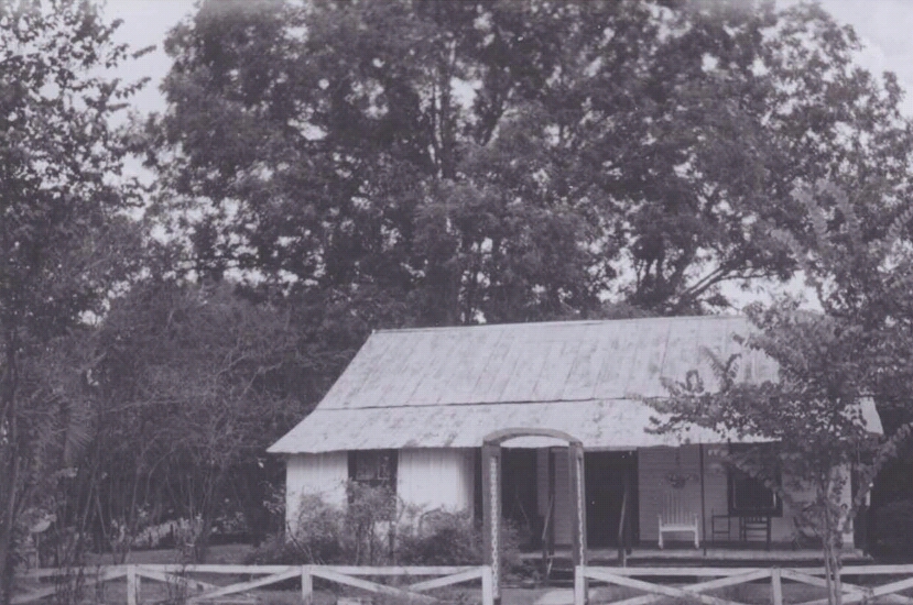
Photograph of Cannon Farm
Photograph by National Park Service, Public domain. Via Wikimedia Commons.

Cannon Farm

Listed on the National Register of Historic Places in 2013. 5 historic topographic surveys show this location, the earliest from 1954.

From the record

“The Cannon Farm is a historic farmstead at 5470 NW 37th Court in Bell, Florida. The main house is a vernacular wood-frame structure that was originally built in 1898 as a schoolhouse when the area was part of Alachua County.”

Wikipedia article Cannon Farm, CC BY-SA 4.0.

One of 1 National Register listings published here for Gilchrist County · listed in 2013 · category: District.

Sources: the Wikipedia article · the National Register database, National Park Service

The listing

  • Address. 5470 NW. 37th Ct., Bell, 32619
  • When was it listed? October 2013
  • Category. district
  • Census division. Bell
  • National Register reference number. 13000851 - assigned by the National Park Service when the property was listed.

Fires near this property

154 since 1992

Regional context, not property-specific evidence. The federal wildfire occurrence database lists 154 fires within 5 miles of Cannon Farm between 1992 and 2019, burning about 1,334 acres in total. 16 started naturally. 6 were recorded as arson. Distance is straight-line from the map coordinates, so a fire counted here may appear on a neighbouring settlement's page as well.

Reported cause Fires
Railroad operations and maintenance43
Debris and open burning40
Equipment and vehicle use19
Missing data/not specified/undetermined18
Natural16
Arson/incendiarism6
Recreation and ceremony3
Power generation/transmission/distribution3
Misuse of fire by a minor2
Other causes2
Smoking1
Fireworks1

The most recent of them, most recent first, with the day each was reported and the service that recorded it.

DateCause SizeReported by Name on the report
8 September 2010Equipment and vehicle use1.0 acresFlorida Forest Service2010-08-0520 FEATHER BUNCHER
7 September 2010Arson/incendiarism10 acresFlorida Forest ServiceGILCHRIST/LOST WORLD FIRE
6 September 1992Natural12 acresFlorida Forest Servicenot named
28 September 2006Debris and open burningunder an acreFlorida Forest ServiceGILCHRIST -- WIREGRASS FIRE
25 September 2019Recreation and ceremony2.0 acresFlorida Forest ServiceNW 101ST(21)
19 September 2007Recreation and ceremonyunder an acreFlorida Forest Service34 - CANOE FIRE #0474
30 August 2009Debris and open burningunder an acreFlorida Forest Service2009-08-0604GILCHRIST
28 August 2007Natural6.0 acresFlorida Forest ServiceAIRPLANE 1

Every fire recorded in Gilchrist County

Mines and quarries near this property

3 within 5 miles

Regional context, not property-specific evidence. The federal mineral resources record lists 3 workings within 5 miles of Cannon Farm: 1 past producer, 1 producer, 1 unknown. 1 still produces. What was taken out: Limestone, General, Stone, Crushed/Broken. Distance is straight-line from the map coordinates, so a quarry counted here may appear on a neighbouring settlement's page as well.

Where SiteCommodity StatusRecorded
Unnamed Limestone QuarryStone, Crushed/BrokenPast Producer
Gilchrist Co. Board of Co. Comm. - Townsend MineLimestone, GeneralUnknownLimestone
Philman - Philman's PitLimestone, GeneralProducerLimestone

Every working recorded in Gilchrist County

Storms near this property

42 since 1995

Regional context, not property-specific evidence. The National Weather Service names Bell, the town this property stands in, in 42 storm reports between 1995 and 2023: 23 thunderstorm wind, 9 hail, 5 heavy rain, 2 lightning. The reports record 2 injuries. Each account below is quoted exactly as the forecast office filed it, from the NOAA Storm Events Database, and each date opens the federal record of that event.

WhenEvent Place namedHarm What the report says
December 1996Thunderstorm WindBell2 hurt, $12,000no account filed
March 2018Thunderstorm WindBell$15,000Multiple barns were damaged and one was completely destroyed. The time of damage was based on radar. The cost of damage was unknown, but it was estimated so the event could be included in Storm Data.
September 1999Thunderstorm WindBell$15,000Large trees were blown down. One tree damaged a car traveling on West 32nd Street.
March 1998Thunderstorm WindBell$5,000Roof Damage
August 1999Thunderstorm WindBell$1,500Large trees and power lines were blown down.
June 1998Thunderstorm WindBell$1,500Large trees were blown down.
September 2018Thunderstorm WindBell$500A tree was blown down near 6209 NW 50th Terrace. The cost of damage was estimated for the event to be included in Storm Data.
July 2000Thunderstorm WindBell$500Large trees were blown down.
June 2017FloodBell$10The roadway at U.S. Highway 129 and County Road 232 East was underwater. The is no known property damage, but a small dollar value was added so this report would be included in Storm Data.
June 2023Thunderstorm WindBell-Trees and power lines were blown down across the NW portion of the county. The time of damage was based on radar data.
June 2023Thunderstorm WindBell-Power lines were blown down at County Road 340 and NW 55th Street.
August 2022Heavy RainBell-A public weather station near Hatchben (KFLBRANF17) measured 3.72 inches of rainfall from about 3:30 pm local time to 6:40 pm local time.
August 2022Thunderstorm WindBell-Trees and power lines were blown down from thunderstorm winds about 3 miles north of Bell.
April 2019Thunderstorm WindBell-Trees and power lines were blown down across the county.
June 2019Heavy RainBell-The Gilchrist County EOC rain gauge measured 2.79 inches of rainfall in 2 hours.
June 2019Heavy RainBell-The WeatherStem station at the Gilchrist County EOC measured a daily total of 2.02 inches.
July 2019Heavy RainBell-An observer near Bell measured 2.28 inches of rainfall within the past 6 hrs.
August 2017Heavy RainBell-Minor street flooding was reported near NW 25th Street near Bell.
September 2017Funnel CloudBell-The Florida Fish and Wildlife reported a funnel cloud east of the Suwanee River south of the County Road 340 bridge.
February 2016Thunderstorm WindBell-Florida Forest Service reported 2 trees down in the Bell area. One was off of SW 10th Street. The time of damage was based on radar.
June 2011Thunderstorm WindBell-Trees were blown down along Highway 129 in Bell. The time of the event was based on radar imagery.
April 2011HailBell-Nickel to dime size hail was reported 2 miles south of CR 340.
July 2010Thunderstorm WindBell-Large tree limbs were blown down. The time of the event was based on radar.
June 2008HailBell-Golf ball size hail was reported about 1 mile south of Bell. The hail lasted about 10 minutes. Strong wind gusts were also observed.
June 2008HailBell-The Cooperative Law Enforcement Station in Bell reported nickel size hail.
June 2008Thunderstorm WindBell-Trees were blown down in Bell.
March 2008Thunderstorm WindBell-Four trees were blown down. Public reported a possible tornado on their property at 5401 NW 22nd Court in Bell. Event time estimated based on radar imagery.
August 2007HailBell-The Bell post office reported dime to nickel size hail.
January 2006HailBell-Hail broke seal on screen room enclosure/addition to a house.
May 2003Thunderstorm WindBell-Large trees and power lines down on County Road 232. Power outages reported.
June 2003Thunderstorm WindBell-Large trees and power lines down.
November 2002Thunderstorm WindBell-2 treess down with scattered power outages.
May 1995Thunderstorm WindBell-Large trees uprooted west of SR 37.
May 2014Funnel CloudBell-no account filed
May 2006LightningBell-no account filed
July 2006Thunderstorm WindBell-no account filed
July 2006LightningBell-no account filed
July 2006HailBell-no account filed
May 2001HailBell-no account filed
May 2000HailBell-no account filed
June 1998Thunderstorm WindBell-no account filed
June 1998HailBell-no account filed

Every storm recorded in Gilchrist County

Maps showing this location

5 surveys

United States Geological Survey topographic sheets whose coverage includes this point. Matched by taking the middle of the area the National Park Service maps for this listing, then testing that coordinate against the published boundary of every sheet.

Sources for this property

National Archives recordThe nomination case file for reference 13000851 in Record Group 79.
Wikipedia articleCommunity-written account of this property, licensed CC BY-SA.
Gilchrist CountyAll 1 listed properties in this county.

Provenance

  • Listing record. National Park Service National Register of Historic Places, listed-properties dataset, current to 2026-05-22.
  • Map join. Address geocoded through the United States Census geocoder, then tested against the published boundary of every sheet in the USGS Historical Topographic Map Collection.
  • How this page is made. Listing fields come from federal records; map-sheet coverage is a labelled coordinate-to-boundary calculation, not a source-field claim.
  • Wildfire. Short, Karen C. 2022. Spatial wildfire occurrence data for the United States, 1992-2020 [FPA_FOD_20221014]. 6th Edition. Fort Collins, CO: Forest Service Research Data Archive. https://doi.org/10.2737/RDS-2013-0009.6 Collected with United States Government funding and usable without additional permissions or fees.
  • Mines and quarries. USGS Mineral Resources Data System (MRDS) https://mrdata.usgs.gov/mrds/ A work of the United States government, no copyright under 17 U.S.C. 105.
  • Storms. NOAA National Centers for Environmental Information, Storm Events Database https://www.ncei.noaa.gov/stormevents/ A work of the United States government, no copyright under 17 U.S.C. 105. Narratives are quoted verbatim from the National Weather Service report and are not edited or summarised.