 Block
From the record
3 National Register listings published here.
Sources: the National Register database, National Park Service
16 topographic sheets cover 9 settlements here, and 3 properties are on the National Register of Historic Places.
3 National Register listings published here.
Sources: the National Register database, National Park Service
Every property in this county listed on the National Register of Historic Places, with the year it was listed and the federal nomination document.
| Photograph | Property | Type | Listed | Reference |
|---|---|---|---|---|
 | Glenwood High School | building | 1997 | 97000923 |
 | Wheeler County Courthouse | building | 1980 | 80001263 |
 | Woodland | building | 1984 | 84001301 |
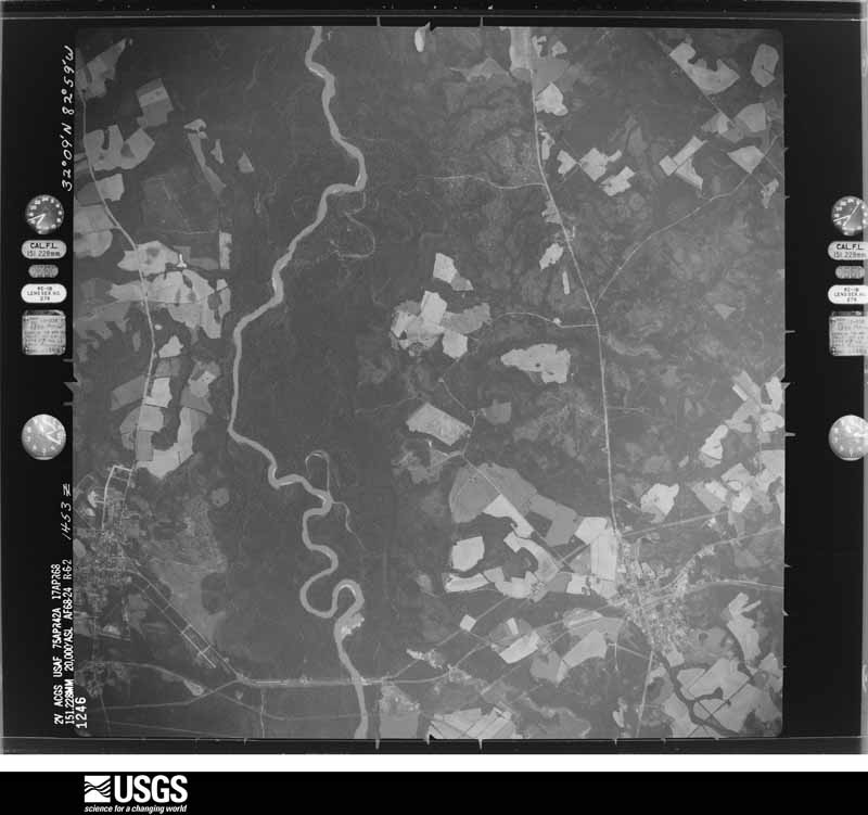
Flown by the U.S. Geological Survey between 1937 and 1989, the Aerial Photo Single Frames collection is the definitive mid-century view of the land: fields, roads and rivers as the camera saw them. The Survey holds 776 frames inside the rectangle that bounds this county; the 24 frames below were taken over the county itself, chosen across the decades of flights (at most four a year from that rectangle), so one flight cannot crowd out the rest. The full set is free to browse and download at EarthExplorer under the dataset Aerial Photo Single Frames.























The thermometers that kept this county's weather, and the gages that measured the flow of its streams, as the federal records hold them.
Who lived here in 1950, one enumeration district at a time, as the Census Bureau described each district. Each row opens its official National Archives result, with Population Schedules and ED Maps available there.
Every wildfire the federal occurrence database records inside this county: 1,525 of them, burning about 4,370 acres. 88 started naturally and 162 were recorded as arson. Each settlement page carries the fires within five miles of it.
| Reported cause | Fires |
|---|---|
| Debris and open burning | 888 |
| Equipment and vehicle use | 228 |
| Arson/incendiarism | 162 |
| Natural | 88 |
| Recreation and ceremony | 57 |
| Missing data/not specified/undetermined | 53 |
| Misuse of fire by a minor | 25 |
| Smoking | 24 |
The five largest, by the area the report gives. One of them was set deliberately.
| Date | Cause | Size | Reported by | Name on the report |
|---|---|---|---|---|
| 29 July 2016 | Natural | 346 acres | Georgia Forestry Commission | FY2017-WHEELER-007 |
| 25 March 2014 | Debris and open burning | 164 acres | Georgia Forestry Commission | FY2014-WHEELER-025 |
| 23 April 1999 | Equipment and vehicle use | 87 acres | Georgia Forestry Commission | not named |
| 23 May 2012 | Natural | 81 acres | Georgia Forestry Commission | FY2012-WHEELER-063 |
| 13 November 2005 | Arson/incendiarism | 81 acres | Georgia Forestry Commission | not named |
| 13 July 2008 | Natural | 78 acres | Georgia Forestry Commission | not named |
| 5 March 2005 | Debris and open burning | 62 acres | Georgia Forestry Commission | not named |
| 4 November 2013 | Debris and open burning | 61 acres | Georgia Forestry Commission | FY2014-WHEELER-008 |
Every settlement page carries the fires within five miles of it - see the settlement index below.
The NOAA Storm Events Database holds 90 reports for this county, causing 2 deaths, 1 injury and about $5,986,400 in recorded property damage. Each settlement page carries the reports that name it.
| Kind of event | Reports |
|---|---|
| Thunderstorm Wind | 67 |
| Hail | 12 |
| Tornado | 8 |
| Flood | 2 |
| Flash Flood | 1 |
The most serious of them, by death, then injury, then recorded damage. The accounts are quoted exactly as the forecast office filed them.
| When | Event | Place named | Harm | What the report says |
|---|---|---|---|---|
| September 2024 | Tornado (EF1) | Jordan | 2 killed | A brief tornado occurred in rural Wheeler County ahead of Hurricane Helene during the evening hours of September 26th. The tornado touched down and crossed Hwy 19 near the intersections of Ponderosa Road and Adams Cemetery Road. A few small trees were|snapped, but the main damage was to a mobile home/trailer that was completely destroyed with debris thrown across Hwy 19 into a field about 75 yards away. The mobile home/trailer was not fastened down and there are no pictures of what it looked like before it was hit. |
| May 1975 | Tornado (F1) | not stated | 1 hurt, $250,000 | no account filed |
| January 1993 | Tornado (F1) | Alamo | $5,000,000 | A small tornado developed at Alamo and moved east-northeast across Wheeler County. Several homes, businesses, and other properties were damaged; 2 mobile homes were destroyed. Several county maintenance and storage buildings were heavily damaged. A school complex had extensive damages, including considerable roof damage to one section. Heavy rain fell through the open roof and damaged the carpets, desks, and other properties. Numerous trees, limbs, and power lines were downed by the tornado. Scattered outages resulted. Residential damage costs were estimated at over $500,000. By 0410EST, the tornado had dissipated and the parent storm moved into Montgomery County. |
| June 1985 | Tornado (F1) | not stated | $250,000 | no account filed |
| May 1984 | Tornado (F1) | not stated | $250,000 | no account filed |
| May 2008 | Thunderstorm Wind | Alamo | $25,000 | The Wheeler County 911 Center reported that dozens of trees and power lines were blown down across the northern and central part of the county, including Alamo and Erik. At least eight roads were blocked and closed from downed trees. |
| December 2006 | Thunderstorm Wind | Spring Hill | $25,000 | The Wheeler County Sheriff reported that a number of trees and several power lines were down in the Spring Hill area. Minor roof damage was also observed to a few homes in the area. |
| April 2017 | Thunderstorm Wind | Alamo | $12,000 | The Wheeler County 911 center reported multiple trees blown down across the county. |
| June 2016 | Thunderstorm Wind | Glenwood | $8,000 | The Wheeler County 911 center reported numerous trees blown down around the intersection of Highways 46 and 19. |
| June 2014 | Thunderstorm Wind | Alamo | $8,000 | The Wheeler County Emergency Manager reported 15 to 20 trees and several power lines down mainly in a two-square-mile area. One tree fell on a small shelter with minor damage. |
| July 2017 | Thunderstorm Wind | Glenwood | $7,000 | The Wheeler County Emergency Manager reported eight or nine trees blown down around the intersection of Highways 19 and 46. |
| August 2019 | Thunderstorm Wind | Stuckey | $6,000 | The public reported a few trees and a power line blown down along Landsburg Road. |
| November 2014 | Thunderstorm Wind | Alamo | $6,000 | The Wheeler County 911 Center reported trees blown down across the county. |
| June 2019 | Thunderstorm Wind | Glenwood | $5,000 | The Wheeler County Emergency Manager reported trees and power lines blown down in the Glenwood area from Still Lane to Cat Squirrel Lane. |
| April 2018 | Thunderstorm Wind | Spring Hill | $5,000 | The Wheeler County Emergency Manager reported several trees blown down around the intersection of Scotland Road and Springhill Road. |
| January 2013 | Thunderstorm Wind | Avants | $5,000 | The Wheeler County Emergency Manager reported that at least a dozen trees were knocked down countywide. A few of those fell on power lines causing short outages. One tree impacted a porch with only minor damage. |
| December 2012 | Tornado (EF1) | Spring Hill | $5,000 | A National Weather Service survey team found a second short-lived tornado in Wheeler County. This tornado was also classified as an EF1 tornado with winds around 100 mph. It caused some minor shingle damage to one structure, and about 50 trees were downed or had their tops sheared off.||[12/17/12: Tornado #3, County #1-1, EF1, Wheeler, 2012:009]. |
| December 2012 | Thunderstorm Wind | Spring Hill | $5,000 | A National Weather Service survey team determined that a thunderstorm downburst uprooted and snapped several trees. This downburst was most likely from a rear-flank downdraft associated with the brief EF1 tornado that occurred nearby. |
| April 2009 | Flood | Avants | $5,000 | The Wheeler County Emergency Management Director reported that several dirt roads across the county were washed out from heavy rain. Minor flooding was also observed to fields and woodlands near streams and creeks. Over six inches of rain fell in parts of the county over a 3-day period. This was on top of saturated soils from prior weeks of above normal rainfall. |
| June 2009 | Thunderstorm Wind | Erick | $5,000 | A trained spotter reported that at least eight trees were down in the far western portion of the county near the Wheeler county line from the Erick and Avants area near Little Ocmulgee State Park to just across the Telfair county line from Scotland. Some county roads were blocked from the downed trees. |
| June 2000 | Thunderstorm Wind | Alamo | $5,000 | The Wheeler county 911 center reported a traffic light was blown down at the intersection of U.S.Highway 280 and Georgia Highway 126. Also several large limbs were blown down on power lines. |
| October 1993 | Thunderstorm Wind | Alamo | $5,000 | Thunderstorm winds blew out windows in a few homes and downed several large trees. |
| April 1997 | Thunderstorm Wind | Mt Vernon | $4,500 | no account filed |
| April 2020 | Thunderstorm Wind | Spring Hill | $4,000 | EM reported two trees down near the intersection of Hope Church Road and Edwards Creek Road. |
| September 2019 | Thunderstorm Wind | Stuckey | $4,000 | The Wheeler County Emergency Manager reported trees blown down on Old Glenwood Road and Lotts Creek Road. |
| June 2018 | Thunderstorm Wind | Jordan | $4,000 | The Wheeler County Emergency Manager reported trees blown down from around St. Paul Church Road and Opossum Road to Hope Church Road near Springhill Road. |
| June 2018 | Thunderstorm Wind | Glenwood | $4,000 | The Wheeler County 911 center reported several trees and power lines blown down across the Glenwood Community. |
| June 2015 | Thunderstorm Wind | Glenwood | $4,000 | The Wheeler County 911 Center reported several trees blown down in the Glenwood area near the intersection of Highway 280 and Highway 19. |
| March 2015 | Thunderstorm Wind | Jordan | $4,000 | The Wheeler County 911 center reported several trees and power lines blown down across the county. |
| August 2006 | Thunderstorm Wind | Alamo | $4,000 | The Wheeler County Emergency Management Director reported that thunderstorm downburst winds blew down well over a dozen trees across the northern part of the county. More than 12 trees were down four miles north of Alamo on Snow Hill Road and more than six trees were down in the north part of Alamo. |
| January 2024 | Thunderstorm Wind | Spring Hill | $3,000 | A few trees down along Springhill Rd SSE of Alamo. |
| January 2024 | Thunderstorm Wind | Spring Hill | $3,000 | A few trees down along Farmers Rd SE of Scotland. |
| July 2024 | Thunderstorm Wind | Erick | $3,000 | Multiple trees down at Bay Springs Church Road and W Hwy 280. |
| July 2023 | Thunderstorm Wind | Stuckey | $3,000 | The emergency manager reported a few trees down in the north end of the county. |
| June 2019 | Thunderstorm Wind | Jordan | $3,000 | The Wheeler County Emergency Manager reported a few trees blown down on Bells Ferry Road and St. Paul Church Road. |
| June 2013 | Thunderstorm Wind | Erick | $3,000 | The Wheeler County Emergency Manager reported that around a dozen trees were blown down across roads. Several power lines were downed as well. |
| April 2011 | Thunderstorm Wind | Spring Hill | $3,000 | A National Weather Service employee confirmed that a storage shed was blown over by straight-line winds, likely less than 50 knots. |
| June 2011 | Thunderstorm Wind | Alamo | $3,000 | The Wheeler County Emergency Management Director reported that several trees were down across the county, but especially along Georgia Highway 19 just north of Jordan. |
| December 2009 | Flood | Avants | $3,000 | The Wheeler County Emergency Management Director reported minor flooding of some roads and property across the county, mostly adjacent to overflowing creeks and streams. Two dirt roads, one near Higgston and another near Alston, were closed because of high water. Monetary damage was confined to minor debris removal in these areas. |
| May 2009 | Thunderstorm Wind | Jordan | $3,000 | The Wheeler County 911 Center reported that several trees and power lines were down in the southern part of the county between Jordan and Lumber City along the Wheeler/Telfair county line. Some trees and power lines were down on Georgia Highway 19. |
| July 2007 | Thunderstorm Wind | Jordan | $3,000 | The Wheeler County Emergency Management Director reported that several trees and power lines were down in the southern part of the county, south of Jordan. |
| July 2003 | Thunderstorm Wind | Alamo | $3,000 | The Little Ocmulgee Electric Membership Cooperative (EMC) reported that several trees were blown down. |
| August 2000 | Thunderstorm Wind | Glenwood | $3,000 | The Little Ocmulgee Electric Membership Cooperative reported several small trees down along with some power lines down. |
| April 2020 | Thunderstorm Wind | Alamo | $2,000 | Tree reported down near the intersection of Hill Farm Road and Hwy 126. |
| January 2017 | Thunderstorm Wind | Jordan | $2,000 | The Wheeler County Emergency Manager reported trees blown down on St. Paul Church Road. |
| April 2014 | Thunderstorm Wind | Glenwood | $2,000 | The Wheeler County 911 Center reported that several trees were blown down over the eastern portion of the county. |
| March 2013 | Thunderstorm Wind | Avants | $2,000 | Employees at the Little Ocmulgee State Park reported that a few trees were blown down on the golf course. A porch also had its roof blown off. |
| February 2008 | Thunderstorm Wind | Alamo | $2,000 | The postal service for the Alamo area reported that several trees were blown down across the northern portion of the county, generally north of a line from Little Ocmulgee State Park to Glenwood. A large tree was down across Georgia Highway 46 in the far northern part of the county and several other trees were down in the area. A few trees were also down within Little Ocmulgee State Park. |
| April 2007 | Thunderstorm Wind | Alamo | $2,000 | The Wheeler County Emergency Management Director reported that from eight to ten trees were blown down across the northern portion of the county. Trees were down on both Georgia Highway 126 and Georgia Highway 19 near the Laurens county line. |
| July 2002 | Thunderstorm Wind | Jordan | $2,000 | The Wheeler county 911 center reported that trees and power lines were down along Georgia Highway 19 from Jordan south to the Telfair county line, near Lumber City. |
| July 1997 | Thunderstorm Wind | Alamo | $2,000 | Several trees were knocked down, mainly east of Alamo. |
| October 2019 | Thunderstorm Wind | Spring Hill | $1,000 | The Wheeler County Emergency Manager reported a tree blown down near the intersection of Hope Church Road and Daisy Lane. |
| May 2018 | Thunderstorm Wind | Spring Hill | $1,000 | The Wheeler County Emergency Manager reported a tree blown down along Farmers Road. |
| May 2017 | Thunderstorm Wind | Jordan | $1,000 | The Wheeler County Emergency Manager reported a tree blown down near the intersection of Highway 19 and St. Paul Church Road. |
| July 2010 | Thunderstorm Wind | Alamo | $1,000 | The Wheeler County 911 Center reported that a few trees were down near the western border of the county, especially in the Spring Hill area. |
| July 2010 | Thunderstorm Wind | Alamo | $1,000 | The Wheeler County 911 Center reported that three trees were down on U.S. Highway 441 near and south of Little Ocmulgee State Park in the far western part of the county, near the Telfair county line. |
| August 2008 | Thunderstorm Wind | Alamo | $500 | The Wheeler County 911 Center reported that a tree was blown down on a power line. |
| March 1993 | Thunderstorm Wind | Alamo | $500 | A few large trees were uprooted and toppled over power lines by thunderstorm winds. |
| June 1996 | Thunderstorm Wind | Alamo | $500 | no account filed |
| July 2000 | Thunderstorm Wind | Alamo | $400 | The Wheeler county 911 center reported a few trees down. |
The Survey's mineral resources record lists 8 workings inside this county. 2 still produce and 6 are closed or unrecorded. Each settlement page carries the workings within five miles of it.
| Commodity | Workings |
|---|---|
| Sand and Gravel, Construction | 8 |
The least common of them first, because a county's hundredth gravel pit says nothing its first ten did not.
| Where | Site | Commodity | Status | Recorded |
|---|---|---|---|---|
| Clegg Mine Jl Clegg Sand | Sand and Gravel, Construction | Producer | ||
| Flanders Mine | Sand and Gravel, Construction | Producer | ||
| Holland Asphalt Sand Pit | Sand and Gravel, Construction | Past Producer | ||
| Unnamed Sand Deposit | Sand and Gravel, Construction | Past Producer | Alluvium | |
| Unnamed Sand Deposit | Sand and Gravel, Construction | Occurrence | Alluvium | |
| Unnamed Sand Deposit | Sand and Gravel, Construction | Occurrence | Alluvium | |
| Unnamed Sand Deposit | Sand and Gravel, Construction | Occurrence | Alluvium | |
| Unnamed Sand Deposit | Sand and Gravel, Construction | Past Producer | Alluvium |
Named settlements recorded in the Geographic Names Information System, each with the topographic sheets covering it. Villages, hamlets and abandoned places alike. Each is shown with the nearest named watercourse or landform and the survey quadrangle it falls on.
Glenwood census division · 30428 · On Eddards Creek · Jordan quadrangle
8 sheets, 1957 to 1988
The complete index, with nothing left out. Each of these is a separate record with its own page: a federal survey report, or the case file that argued a property on to the National Register. Both are public domain and reproduced word for word.