
BlockBefore
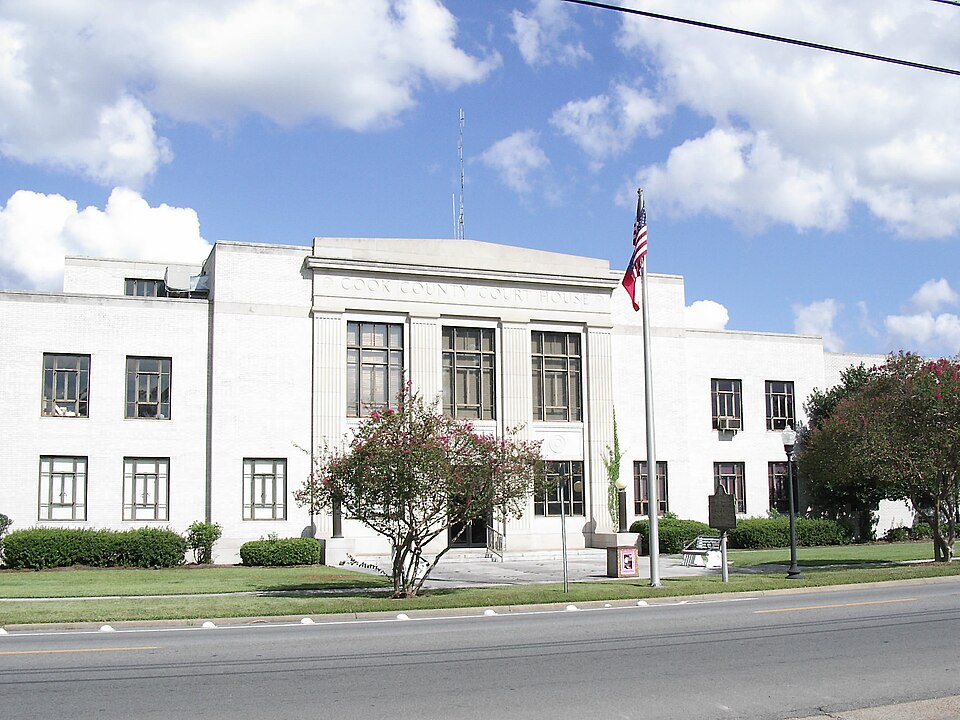
Photograph of Cook County Courthouse
Photograph by ​ Englisch Wikipedia user Mjrmtg, CC BY-SA 3.0. Via Wikimedia Commons.

Cook County Courthouse

Listed on the National Register of Historic Places in 1995.

From the record

“The Cook County Courthouse in Adel, Georgia is a building built in 1939. It was designed by Atlanta architect William J.”

Wikipedia article Cook County Courthouse (Georgia), CC BY-SA 4.0.

One of 3 National Register listings published here for Cook County · listed in 1995 · category: Building.

Sources: the Wikipedia article · the case file at the National Archives · the National Register database, National Park Service

The listing

  • What is counted as historic. The nomination lists 1 building as contributing to the listing.
  • Address. 212 N. Hutchinson Ave., Adel, 31620
  • When was it listed? June 1995
  • Category. building
  • Also known as. Georgia County Courthouses TR
  • Census division. Adel-Sparks
  • Architectural style. Stripped Classicism
  • National Register reference number. 95000714 - the number the National Park Service assigned this property when it was listed, and the key its nomination file is catalogued under at the National Archives.

Fires near this property

719 since 1992

Regional context, not property-specific evidence. The federal wildfire occurrence database lists 719 fires within 5 miles of Cook County Courthouse between 1992 and 2020, burning about 3,123 acres in total. 17 started naturally. 53 were recorded as arson. Distance is straight-line from the map coordinates, so a fire counted here may appear on a neighbouring settlement's page as well.

Reported cause Fires
Debris and open burning502
Equipment and vehicle use82
Arson/incendiarism53
Missing data/not specified/undetermined22
Natural17
Misuse of fire by a minor14
Railroad operations and maintenance10
Smoking10
Recreation and ceremony9

The most recent of them, most recent first, with the day each was reported and the service that recorded it.

DateCause SizeReported by Name on the report
9 September 1998Debris and open burning2.1 acresGeorgia Forestry Commissionnot named
9 September 1998Missing data/not specified/undetermined1.5 acresGeorgia Forestry Commissionnot named
9 September 1997Equipment and vehicle useunder an acreGeorgia Forestry Commissionnot named
9 September 1995Debris and open burning6.5 acresGeorgia Forestry Commissionnot named
7 September 1999Naturalunder an acreGeorgia Forestry Commissionnot named
6 September 1999Recreation and ceremonyunder an acreGeorgia Forestry Commissionnot named
30 September 2003Debris and open burning2.8 acresGeorgia Forestry Commissionnot named
30 September 2003Debris and open burning7.3 acresGeorgia Forestry Commissionnot named

Every fire recorded in Cook County

Mines and quarries near this property

1 within 5 miles

Regional context, not property-specific evidence. The federal mineral resources record lists 1 working within 5 miles of Cook County Courthouse: 1 unknown. None of them still produces. What was taken out: Phosphorus-Phosphates. Distance is straight-line from the map coordinates, so a quarry counted here may appear on a neighbouring settlement's page as well.

Where SiteCommodity StatusRecorded
Adel Milling Co/ Adel, Ga.Phosphorus-PhosphatesUnknown

Every working recorded in Cook County

Storms near this property

32 since 1993

Regional context, not property-specific evidence. The National Weather Service names Adel, the town this property stands in, in 32 storm reports between 1993 and 2025: 18 thunderstorm wind, 5 hail, 5 flash flood, 4 lightning. The reports record 1 injury. Each account below is quoted exactly as the forecast office filed it, from the NOAA Storm Events Database, and each date opens the federal record of that event.

WhenEvent Place namedHarm What the report says
June 2011Thunderstorm WindAdel1 hurt, $30,000A restaurant in downtown Adele at the intersection of Highway 37 and Highway 41 had its roof peeled back by downburst winds. Three homes were also damage by falling trees with one injury reported in one home due to a fallen tree. The monetary damage figure provided is a rough estimate.
March 1993Thunderstorm WindAdel$500,000Thunderstorm winds severely damaged a manufacturing plant in Adel. Approximately 35,000 square feet of the building was destroyed while another 20,000 square feet was heavily damaged. In a trailer park in Adel, one trailer was flipped over and another had its roof removed.
June 1998Thunderstorm WindAdel$175,000Severe thunderstorm winds raked the Cook County Airport in Adel, damaging four planes and two hangars. The winds knocked out power to 1,000 Sparks residents. A few billboards near Interstate 75 were damaged.
January 2017Thunderstorm WindAdel$50,000The Colquitt Electric Membership Corporation reported numerous power poles and power lines down through portions of Berrien, Brooks, Colquitt, Cook, and Lowndes counties.
June 2009LightningAdel$50,000Numerous lightning strikes damaged fuses in the City of Adel's electrical system. About 350 electric customers were without power for a few hours.
May 1998HailAdel$50,000Golfball to baseball sized hail damaged numerous vehicles and residences in and around Adel.
May 1997Thunderstorm WindAdel$30,000no account filed
August 2008LightningAdel$15,000Lightning struck a communications tower in Adel and burned some components. The damage caused 200 customers to lose Internet service.
June 2007Thunderstorm WindAdel$15,000Numerous trees were down across the southwest portion of the county. There was minor damage to a few homes.
March 2023Thunderstorm WindAdel$10,000There were a couple of downed power lines as well as one tree that fell on a vehicle. In addition, a couple of tree tops broke off and landed on roofs.
June 2011LightningAdel$10,000Lightning caused a house fire in Adel. The monetary damage figure provided is a rough estimate.
June 2022LightningAdel$5,000A lightning strike to a gas line near 816 S Gordon Ave resulted in a fire.
February 2012Thunderstorm WindAdel$5,000The Cook county 911 call center reported trees down and power outages around Adel. Monetary damage was estimated.
May 2004Flash FloodAdel$5,000Several county roads surrounding Adel were flooded. Two to four inches of rain fell in two hours, which caused a half-foot rise in the Little River basin. Reported by the Cook County EMA.
May 2021Thunderstorm WindAdel$2,000A power line was blown down in Adel.
July 2012Thunderstorm WindAdel$1,000The Cook county 911 dispatch reported a tree down on Caulie Harris Road. Monetary damage was estimated.
December 2004Thunderstorm WindAdel$1,000Numerous trees were down. Reported by the Cook County Sheriff.
June 1994Thunderstorm WindAdel$500A few large trees were blown down across U.S. Highway 41.
May 2025Flash FloodAdel-There were a few roads flooded in the Adel and Sparks areas.
May 2024Flash FloodAdel-Flooding was reported on Highway 37 in both directions at Pine Street.
June 2024Thunderstorm WindAdel-There were a couple reports of trees down in Cook county.
July 2022Thunderstorm WindAdel-Several large trees were blown down near the area of Highway 37 and Indian Creek Road and were blocking the highway.
July 2022Flash FloodAdel-A motorist reported water over the roadway on Coxstill Road.
December 2021Thunderstorm WindAdel-Trees were blown down with some debris in roadways in the Adel area.
April 2018Thunderstorm WindAdel-A tree was blown down in Adel.
January 2017Thunderstorm WindAdel-Trees were blown down on Livingston Road.
April 2015HailAdel-Nickel size hail was reported in Adel for 5 minutes with little to no wind.
July 2015Thunderstorm WindAdel-A few trees were blown down in Adel.
July 2015Flash FloodAdel-A stationary thunderstorm over Adel resulted in very heavy rainfall in a short period of time. Some streets had water up to a foot deep and were briefly closed.
March 2013HailAdel-Golf ball size hail was reported via WALB's facebook page.
March 2013HailAdel-Golf ball size hail was confirmed via a photograph about 5 miles east of Adel.
June 2023HailAdel-no account filed

Every storm recorded in Cook County

Map coverage status

No historic map-sheet match is published for this property yet. That does not mean no map exists. This record needs a coordinate-quality review before it can be joined to a sheet boundary. Browse the county's mapped places while that work is pending.

Listed places nearby

2 within 8 miles

Other National Register properties close enough to walk or drive between, ordered by distance from this one. Both positions come from the same geocoding pass that matched these properties to their map sheets.

Photograph PropertyDistance Listed
SOWEGA Building0.2 miles1990
United States Post Office-Adel, Georgia0.2 miles2009

Sources for this property

National Archives recordThe nomination case file for reference 95000714 in Record Group 79.
Wikipedia articleCommunity-written account of this property, licensed CC BY-SA.
Cook CountyAll 3 listed properties in this county.

Provenance

  • Listing record. National Park Service National Register of Historic Places, listed-properties dataset, current to 2026-05-22.
  • Map join. Address geocoded through the United States Census geocoder, then tested against the published boundary of every sheet in the USGS Historical Topographic Map Collection.
  • How this page is made. Listing fields come from federal records; map-sheet coverage is a labelled coordinate-to-boundary calculation, not a source-field claim.
  • Wildfire. Short, Karen C. 2022. Spatial wildfire occurrence data for the United States, 1992-2020 [FPA_FOD_20221014]. 6th Edition. Fort Collins, CO: Forest Service Research Data Archive. https://doi.org/10.2737/RDS-2013-0009.6 Collected with United States Government funding and usable without additional permissions or fees.
  • Mines and quarries. USGS Mineral Resources Data System (MRDS) https://mrdata.usgs.gov/mrds/ A work of the United States government, no copyright under 17 U.S.C. 105.
  • Storms. NOAA National Centers for Environmental Information, Storm Events Database https://www.ncei.noaa.gov/stormevents/ A work of the United States government, no copyright under 17 U.S.C. 105. Narratives are quoted verbatim from the National Weather Service report and are not edited or summarised.