 Block
From the record
5 National Register listings published here.
Sources: the National Register database, National Park Service
24 topographic sheets cover 18 settlements here, and 5 properties are on the National Register of Historic Places.
5 National Register listings published here.
Sources: the National Register database, National Park Service
Every property in this county listed on the National Register of Historic Places, with the year it was listed and the federal nomination document.
| Photograph | Property | Type | Listed | Reference |
|---|---|---|---|---|
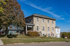 | Adams County Jail | building | 1991 | 91000119 |
 | Corning Commercial Historic District | district | 2012 | 12000318 |
| Corning Opera House | building | 1993 | 93000954 | |
 | Noah Odell House | building | 2000 | 00000917 |
 | Snider Bridge | structure | 1998 | 98000774 |
Every wildfire the federal occurrence database records inside this county: 37 of them, burning about 588 acres. None started naturally and none was recorded as arson. Each settlement page carries the fires within five miles of it.
| Reported cause | Fires |
|---|---|
| Missing data/not specified/undetermined | 17 |
| Debris and open burning | 15 |
| Smoking | 2 |
| Equipment and vehicle use | 2 |
| Railroad operations and maintenance | 1 |
The five largest, by the area the report gives. None of them was recorded as arson.
| Date | Cause | Size | Reported by | Name on the report |
|---|---|---|---|---|
| 11 April 2009 | Missing data/not specified/undetermined | 120 acres | Iowa Department of Natural Resources | not named |
| 4 March 2017 | Debris and open burning | 110 acres | Iowa Department of Natural Resources | not named |
| 2 February 2006 | Missing data/not specified/undetermined | 80 acres | Iowa Department of Natural Resources | not named |
| 16 October 2020 | Debris and open burning | 60 acres | Iowa Department of Natural Resources | not named |
| 13 October 2020 | Debris and open burning | 30 acres | Iowa Department of Natural Resources | not named |
| 26 March 2014 | Debris and open burning | 30 acres | Iowa Department of Natural Resources | not named |
| 22 March 2007 | Missing data/not specified/undetermined | 20 acres | Iowa Department of Natural Resources | not named |
| 26 November 2017 | Missing data/not specified/undetermined | 20 acres | Iowa Department of Natural Resources | not named |
Every settlement page carries the fires within five miles of it - see the settlement index below.
The NOAA Storm Events Database holds 273 reports for this county, causing 1 death, 6 injuries and about $37,008,500 in recorded property damage. Each settlement page carries the reports that name it.
| Kind of event | Reports |
|---|---|
| Hail | 102 |
| Thunderstorm Wind | 81 |
| Tornado | 26 |
| Flash Flood | 26 |
| Heavy Rain | 25 |
| Flood | 6 |
| Funnel Cloud | 6 |
| Lightning | 1 |
The most serious of them, by death, then injury, then recorded damage. The accounts are quoted exactly as the forecast office filed them.
| When | Event | Place named | Harm | What the report says |
|---|---|---|---|---|
| May 2024 | Tornado (EF3) | Nodaway | 1 killed, $1,800,000 | The tornado entered into Adams County after clipping the northwest corner of Taylor County. Damage was immediate on the county border with damage to trees and and to farm buildings and power poles within the first few miles in the county. The tornado continued to gain in strength and size as it travelled northeast through southwest Adams county remaining in rural areas south and east of Nodaway. The tornado eventually crossed Federal Highway 34 just north of Brooks with plenty of videos showing a large funnel with debris swirling below it. As the tornado crossed State Highway 148, it gained in strength with EF2 damage becoming more common. Upon reaching the intersection of 150th Street and Notchwood Avenue, EF3 damage occurred with much of an unanchored house losing walls and sliding off the foundation. All outbuildings at this site were also destroyed. As the tornado continued into the north central portion of the county, it encountered several industrial wind mills. Several of the towers collapsed along with the large blades being tossed hundreds of feet through the air. The tornado was multi-vortex at this point with a width of 1300 yards. The tornado exited the county into Adair County between Quince Avenue and Redwood Avenue. The was one death in the county from this tornado when a female driver was ejected from a vehicle which got caught within the circulation. |
| May 2004 | Thunderstorm Wind | Corning | 2 hurt, $50,000 | no account filed |
| April 1999 | Tornado (F4) | Nodaway | 1 hurt, $1,000,000 | no account filed |
| July 1958 | Tornado (F3) | not stated | 1 hurt, $250,000 | no account filed |
| April 2001 | Tornado (F1) | Mt Etna | 1 hurt, $100,000 | Trailer house overturned and destroyed. Roofs torn off of two sheds. |
| April 1989 | Thunderstorm Wind | not stated | 1 hurt | no account filed |
| May 1989 | Tornado (F4) | not stated | $25,000,000 | no account filed |
| June 1984 | Tornado (F3) | not stated | $2,500,000 | no account filed |
| May 2024 | Tornado (EF3) | Dickieville | $1,000,000 | The tornado entered into Adams County from Montgomery County. This tornado remained in rural areas of western and northern Adams County until lifting north of the town of Carl near the Adair County line. The tornado impacted a house on the north side of 200th street shortly after entering the county removing much of the roof with general collapse of the structure. A large hog confinement facility near the intersection of 190th and Aspen was severally damage with most buildings destroyed. EF3 damage occurred to a house along 175th Street near Cherry Avenue with all wall removed except a couple of the interior walls. The outbuildings at this location were all destroyed as well. Another house along 150th Street near Dogwood Avenue had all but a few interior walls removed with EF3 damage as well. All outbuildings were destroyed at this site as well. The tornado turned slightly to the right at this point with only limited interaction with building sites but plenty of tree damage for the remainder of it path. |
| July 2015 | Flood | Lincoln Center | $250,000 | Flooding was reported across much of the county with water affecting roads and low lying areas. Numerous secondary roads across the county remain closed with water flowing over them. |
| September 2001 | Thunderstorm Wind | Corning | $250,000 | no account filed |
| August 1988 | Tornado (F1) | not stated | $250,000 | no account filed |
| May 1959 | Tornado (F2) | not stated | $250,000 | no account filed |
| August 2015 | Tornado (EF1) | Williamson | $200,000 | This segment is for Adams county. This very visible tornado meandered across Adair and Adams counties for over half an hour, traveling only 8.5 miles in that time. The worst damage occurred near the small hamlet of Williamson where multiple buildings were damaged. The tornado initially traveled to the SW-SE, but executed a cyclonic loop two miles south of Williamson and then traveled to the N-NE for the remainder of its life. |
| May 2011 | Flash Flood | Nodaway | $200,000 | Several places throughout Nodaway reported 6 inches of flowing water over roads and inundating homes and businesses. |
| June 2008 | Flood | Corning | $200,000 | Several houses and businesses on the northeast side of Corning have been inundated with water. |
| May 2007 | Flood | Lincoln Center | $200,000 | no account filed |
| July 2015 | Flash Flood | Prescott | $150,000 | Emergency Manager reported several roads in Corning and Prescott have street flooding. Also reported several gravel roads south of Highway 34 are flooded. |
| June 2014 | Flash Flood | Quincy | $150,000 | Many roads washed out across western Adams County west of Highway 148 and north of Highway 34. |
| April 2012 | Thunderstorm Wind | Mt Etna | $150,000 | Farm buildings were destroyed by high winds. |
| May 2011 | Flash Flood | Nodaway | $150,000 | Adams County Law Enforcement reported railroad tracks washed out between track mile posts 423 and 424. |
| September 2001 | Thunderstorm Wind | Corning | $150,000 | no account filed |
| May 2024 | Tornado (EF1) | Mercer | $100,000 | This tornado developed in rural Adams County southeast of Corning. It remained in agricultural fields initially before impacting a farmstead along Highway 34. Two outbuildings were damaged at this location. Additional homesteads were impacted with mostly minor damage. The EF1 damage occurred just before the tornado departed the county were a grove of trees sustained more significant damage. The tornado then entered Union County just northwest of Cromwell. |
| June 2014 | Flash Flood | Stringtown | $100,000 | Water was reported over many county roadways. |
| July 2008 | Flash Flood | Stringtown | $100,000 | The Adams County law enforcement reported that highway 34 was closed at Sycamore Ave near Stringtown due to water over the road, County Road H45 was closed southeast of Corning and anther road was closed near Mount Etna. Widespread street flooding was reported as well in Prescott and Corning. |
| June 2010 | Flood | Corning | $100,000 | no account filed |
| April 2006 | Thunderstorm Wind | Prescott | $100,000 | no account filed |
| June 2014 | Lightning | Corning | $80,000 | A home in the city of Corning was a total loss after it burned down following a lightning strike. |
| September 2014 | Thunderstorm Wind | Corning | $75,000 | Heavy damage to a machine shed and trees caused by strong straight-line winds. |
| May 2014 | Thunderstorm Wind | Mercer | $75,000 | Barn blown down by high winds. |
| April 2016 | Thunderstorm Wind | Mercer | $50,000 | A semi was reported flipped and a shed destroyed along Hwy 34. |
| July 2016 | Thunderstorm Wind | Quincy | $50,000 | Emergency Manager reported a path of wind damage from 183rd and Hickory Ave in Quincy to Lake Icaria. Numerous trees were down and two campers flipped at the Lake Icaria campgrounds. Time of start point estimated via radar. |
| June 2014 | Thunderstorm Wind | Brooks | $50,000 | Significant damage was done to a home near Brooks. Siding and shutters were wrecked, windows broken by hail as well. |
| June 2014 | Flash Flood | Dickieville | $50,000 | Aspen Ave was reported washed out between 175th and 190th. |
| May 2013 | Hail | Carbon | $50,000 | Hail completely covered the ground. |
| May 2013 | Hail | Carbon | $50,000 | Two to three inch hail received via social media. |
| April 2012 | Tornado (EF1) | Stringtown | $50,000 | Tornado developed about one half mile west of the Adams/Union county line in Adams county. The tornado did EF1 damage to a farmstead shortly after developing. Shortly thereafter, the tornado continued into Union county. |
| October 2007 | Flood | Lincoln Center | $50,000 | Barricades were placed at 110th and Birch with water flowing over the road. |
| September 1993 | Hail | Mount Etna | $50,000 | A warm front was to the south of Iowa while a cold front was approaching from the Dakotas. At the same time, a moderate to strong southerly flow of air developed in the lower levels of the atmosphere. This flow drew moisture in a shallow layer of moisture northward from the remnants of Hurricane Gert. Thunderstorms erupted over Kansas and southeast Nebraska, then moved into southwest Iowa. Heavy rainfall occurred over the southwest counties of the state. Reports of 1.50 to 2.50 inches of rain were common over a seven county area. Since soil moisture conditions were at the saturation point, all rainfall quickly ran off causing widespread flash flooding. Generally speaking, the flooding was fairly minor by this summers standards, but still several roads were overtopped with flood waters. The storms did produce gusty winds and several reports of pea-size to a little larger hail. One of the storms did produce larger hail. A storm which, had reached tops in excess of 60,000 feet at one point, moved into Adams County. Hail a little larger than quarters pounded an area west of Mount Etna for 30 minutes. The actual location of most of the hail was in Lincoln Township, the northwest corner, one half mile south of the Cass/Adams County border on county road N28. Crop damage in the area was extensive. |
| May 2004 | Thunderstorm Wind | Corning | $50,000 | no account filed |
| July 2000 | Flash Flood | East Portion | $50,000 | no account filed |
| June 1997 | Thunderstorm Wind | Corning | $50,000 | no account filed |
| April 1994 | Hail | Corning | $50,000 | no account filed |
| March 2020 | Tornado (EF0) | Carl | $30,000 | Tornado developed just south of the Adams/Adair county line moving northeast. The tornado encountered a farmstead producing EF0 damage to an outbuilding. The northeast trajectory took the tornado into Adair county shortly after impacting the farmstead. |
| June 2008 | Thunderstorm Wind | Carbon | $30,000 | High winds destroyed a machine shed. |
| March 2002 | Thunderstorm Wind | Carbon | $30,000 | no account filed |
| November 2015 | Thunderstorm Wind | Stringtown | $25,000 | Trained spotter reported a semi blown over by high winds on Highway 34. |
| June 2014 | Thunderstorm Wind | Corning | $25,000 | A large amount of tree damage was reported with leaves stripped and 5 inch diamter branches down. |
| April 2012 | Thunderstorm Wind | Lincoln Center | $25,000 | Cars were damaged with trees down. A transformer was blown. Funnel clouds were also observed. |
| May 2011 | Flash Flood | Nodaway | $25,000 | Water flowing over rural roads in several locations of southwest Adams County. EM had to turn around one half mile south of Nodaway due to flash flooding. |
| May 2011 | Flash Flood | Nodaway | $25,000 | Water reported up to the railroad tracks. |
| June 2011 | Flash Flood | Prescott | $25,000 | Six to 8 inches of water flowing over a road at Union Ave just south of 150th St. Also occurring at Vanilla Ave and 150th St. |
| June 2010 | Flash Flood | Nevinville | $25,000 | Water over Willow Road near the intersection of 150th St. |
| June 2010 | Flash Flood | Nevinville | $25,000 | Water over the roads near 150th and Union. |
| March 2009 | Thunderstorm Wind | Carbon | $25,000 | A motor home has been blown on its side, with part of a roof blown off a house. Power poles were blown down, with all the debris lying off to the northeast. |
| June 2008 | Flash Flood | Stringtown | $25,000 | Water was running over Highway 34. |
| June 2008 | Tornado (EF1) | Stringtown | $25,000 | A storm chaser reports tornado entering southwest Corning with debris cloud. |
| June 2008 | Flash Flood | Mt Etna | $25,000 | Water was reported over many cross roads with 110th St across the northern portion of the county. |
| June 2014 | Hail | Mercer | $25,000 | no account filed |
| June 2010 | Hail | Corning | $25,000 | no account filed |
The Survey's mineral resources record lists 2 workings inside this county. All of them still produce. Each settlement page carries the workings within five miles of it.
| Commodity | Workings |
|---|---|
| Sand and Gravel, Construction, Stone, Crushed/Broken | 1 |
| Stone, Crushed/Broken | 1 |
The least common of them first, because a county's hundredth gravel pit says nothing its first ten did not.
| Where | Site | Commodity | Status | Recorded |
|---|---|---|---|---|
| Corning Quarry | Stone, Crushed/Broken | Producer | ||
| Mt Etna Quarry | Sand and Gravel, Construction, Stone, Crushed/Broken | Producer |
Named settlements recorded in the Geographic Names Information System, each with the topographic sheets covering it. Villages, hamlets and abandoned places alike. Each is shown with the nearest named watercourse or landform and the survey quadrangle it falls on.
Prescott township · 50841 · Corning South quadrangle
8 sheets, 1955 to 1985
No longer a settlement
Prescott township · 50859 · On Mount Zion Branch · Prescott quadrangle
9 sheets, 1954 to 1993
Quincy township · 50841 · Corning North quadrangle
9 sheets, 1954 to 1993
No longer a settlement
The vanished settlements of Adams County: the places named above that are no longer on the map.