 Block
From the record
15 National Register listings published here.
Sources: the National Register database, National Park Service
18 topographic sheets cover 15 settlements here, and 15 properties are on the National Register of Historic Places.
15 National Register listings published here.
Sources: the National Register database, National Park Service
Every property in this county listed on the National Register of Historic Places, with the year it was listed and the federal nomination document.
| Photograph | Property | Type | Listed | Reference |
|---|---|---|---|---|
 | Audobon County Court House | building | 2003 | 03000826 |
 | Audubon County Courthouse | building | 1977 | 77000493 |
 | Audubon County Home Historic District | district | 2015 | 15000080 |
| Bennedsen, Boldt, and Hansen Building | building | 1991 | 91001460 | |
| Bethany Danish Evangelical Lutheran Church | building | 1991 | 91001457 | |
 | John D. Bush House | building | 1991 | 91001461 |
| Andrew P. Hansen Farmstead | building | 1991 | 91001458 | |
 | Immanuel Danish Evangelical Lutheran Church | building | 1991 | 91001462 |
 | Hans J. Jorgensen Barn | building | 1991 | 91001452 |
 | Kimballton Commercial District | district | 1995 | 95001016 |
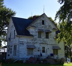 | Kimballton West 2nd-West 3rd Street Residential District | district | 1995 | 95001017 |
| Hans M. Koch House | building | 1991 | 91001453 | |
| Jens T. Larsen House | building | 1991 | 91001451 | |
| Poplar Rural District | district | 1992 | 91001463 | |
| Ross Grain Elevator | structure | 2018 | 100002575 |
Every wildfire the federal occurrence database records inside this county: 15 of them, burning about 334 acres. None started naturally and none was recorded as arson. Each settlement page carries the fires within five miles of it.
| Reported cause | Fires |
|---|---|
| Debris and open burning | 10 |
| Missing data/not specified/undetermined | 5 |
The five largest, by the area the report gives. None of them was recorded as arson.
| Date | Cause | Size | Reported by | Name on the report |
|---|---|---|---|---|
| 10 March 2012 | Missing data/not specified/undetermined | 100 acres | Iowa Department of Natural Resources | not named |
| 15 March 2017 | Debris and open burning | 60 acres | Iowa Department of Natural Resources | not named |
| 30 March 2015 | Debris and open burning | 60 acres | Iowa Department of Natural Resources | not named |
| 10 April 2020 | Debris and open burning | 50 acres | Iowa Department of Natural Resources | not named |
| 29 April 2010 | Missing data/not specified/undetermined | 40 acres | Iowa Department of Natural Resources | 1464 210TH ST., AUDUBON, IOWA |
| 2 April 2013 | Debris and open burning | 10 acres | Iowa Department of Natural Resources | not named |
| 8 October 2006 | Missing data/not specified/undetermined | 10 acres | Iowa Department of Natural Resources | not named |
| 12 May 2007 | Missing data/not specified/undetermined | 2.0 acres | Iowa Department of Natural Resources | not named |
Every settlement page carries the fires within five miles of it - see the settlement index below.
The NOAA Storm Events Database holds 270 reports for this county, causing no deaths, 1 injury and about $2,784,500 in recorded property damage. Each settlement page carries the reports that name it.
| Kind of event | Reports |
|---|---|
| Hail | 117 |
| Thunderstorm Wind | 97 |
| Heavy Rain | 23 |
| Tornado | 14 |
| Flash Flood | 11 |
| Flood | 8 |
The most serious of them, by death, then injury, then recorded damage. The accounts are quoted exactly as the forecast office filed them.
| When | Event | Place named | Harm | What the report says |
|---|---|---|---|---|
| May 1968 | Tornado (F1) | not stated | 1 hurt, $25,000 | no account filed |
| June 2013 | Thunderstorm Wind | Sharon | $250,000 | Winds lasted 30 minutes in the Audubon area. Tree limbs 4 to 5 inches in diameter were down, corn flattened, town totally without electricity. A farmstead lost 2 buildings southwest of town. |
| April 2007 | Flood | Audubon | $250,000 | no account filed |
| May 2007 | Flood | Gray | $250,000 | no account filed |
| May 2004 | Flash Flood | Countywide | $150,000 | no account filed |
| March 2019 | Flood | Gray | $100,000 | County reported multiple secondary roads in Audubon County closed due to flooding. |
| June 2011 | Thunderstorm Wind | Audubon | $100,000 | High winds in Audubon caused damage to a local church. A structure holding the Ten Commandments was destroyed by the winds as they were torn down from the church. |
| June 1998 | Flood | Audubon | $100,000 | no account filed |
| December 2021 | Tornado (EF1) | Brayton | $75,000 | Tornado moved into Audubon county from Cass county. This tornado remained on the ground in rural areas of southeastern Audubon county. Damage was primarily to trees with one garage being destroyed east of Exira producing an EF1 rating. |
| May 2007 | Flash Flood | Audubon Arpt | $75,000 | no account filed |
| May 1998 | Thunderstorm Wind | Exira | $75,000 | no account filed |
| December 2021 | Tornado (EF1) | Brayton | $50,000 | This tornado continued into Audubon county from Cass county. The tornado remains in rural portions of southern and central Audubon county. Most damage was to farm outbuildings, trees and power poles with EF1 the highest damage rating observed. |
| May 2007 | Flash Flood | Audubon | $50,000 | no account filed |
| May 2007 | Flash Flood | Exira | $50,000 | no account filed |
| May 2004 | Flash Flood | Audubon | $50,000 | no account filed |
| August 2002 | Flash Flood | Brayton | $50,000 | no account filed |
| October 2002 | Thunderstorm Wind | Hamlin | $50,000 | no account filed |
| June 1996 | Flood | Audubon | $50,000 | no account filed |
| June 1994 | Hail | Exira | $50,000 | no account filed |
| May 1998 | Thunderstorm Wind | Audubon | $45,000 | no account filed |
| May 2015 | Thunderstorm Wind | Viola Center | $35,000 | A machine shed on a farm was destroyed. |
| June 2013 | Flash Flood | Kenfield | $30,000 | Water overtopped the bridge on County Highway F58 near 340th St. Tree debris was left on the road. Water was receding as of 0405 CST. |
| September 2011 | Thunderstorm Wind | Audubon | $30,000 | Numerous tree branches were down all over town. |
| August 2007 | Thunderstorm Wind | Audubon | $30,000 | no account filed |
| April 2001 | Thunderstorm Wind | Audubon | $30,000 | no account filed |
| June 1996 | Flood | Audubon | $30,000 | no account filed |
| June 2014 | Thunderstorm Wind | Kenfield | $25,000 | Damage was reported at the Littlefield Recreation Area. |
| May 2004 | Flash Flood | Kimballton | $25,000 | no account filed |
| July 2002 | Thunderstorm Wind | Gray | $25,000 | no account filed |
| July 1996 | Thunderstorm Wind | Viola Center | $25,000 | no account filed |
| September 1977 | Tornado | not stated | $25,000 | no account filed |
| June 1976 | Tornado (F2) | not stated | $25,000 | no account filed |
| July 1998 | Thunderstorm Wind | Audubon | $20,000 | no account filed |
| August 2007 | Thunderstorm Wind | Audubon | $15,000 | Winds blew down a few large trees and several 5 to 10 inch diameter limbs were downed in Audubon. |
| March 2006 | Thunderstorm Wind | Audubon Arpt | $15,000 | no account filed |
| April 2001 | Thunderstorm Wind | Audubon | $15,000 | no account filed |
| July 1999 | Hail | Audubon | $15,000 | no account filed |
| May 2024 | Tornado (EF0) | Brayton | $10,000 | The tornado developed southeast of Brayton and moved northeast in rural southern Audubon County. The bulk of the damage done was to trees. There was also a TDS associated with this tornado on the radar. The tornado dissipated a few miles east of Exira. |
| May 2024 | Thunderstorm Wind | Audubon | $10,000 | Emergency manager reported power lines down on the northeast side of Audubon. Time estimated from radar. |
| August 2015 | Hail | Viola Center | $10,000 | Public reported quarter sized hail along with some trees snapped off in the area. Delayed report and time estimated from radar. |
| June 2013 | Thunderstorm Wind | Audubon | $10,000 | Winds estimated up to 70 MPH causing the building to shake. Spotter unable to open doors to outside due to wind. |
| May 2012 | Flash Flood | Ross | $10,000 | Water covering the County Highway N14 bridge that crosses Indian Creek. About one half mile of the road was under water. The worst area of flooding was 5 miles either side of a line from Kimballton to Audubon. A log was left on a bridge over the creek after the water had receded. Multiple locations required gravel grading and debris removal off of county roads. |
| June 2010 | Thunderstorm Wind | Gray | $10,000 | Tree branches were on electrical lines with power out in Gray. |
| June 2010 | Thunderstorm Wind | Gray | $10,000 | Numerous tree branches down in the Gray area. |
| June 2009 | Thunderstorm Wind | Gray | $10,000 | Strong straight line winds caused sparking of transformers. Large branches were down and a tree fell on a car. |
| May 2008 | Thunderstorm Wind | Viola Center | $10,000 | Two power poles were downed. |
| September 2007 | Thunderstorm Wind | Audubon | $10,000 | Wind report was from the Audubon Community schoolnet. ID SAUI4. |
| June 2014 | Hail | Exira | $10,000 | no account filed |
| August 2007 | Flash Flood | Imballton | $10,000 | no account filed |
| May 2005 | Hail | Kimballton | $10,000 | no account filed |
| May 2005 | Hail | Audubon | $10,000 | no account filed |
| May 2004 | Hail | Audubon | $10,000 | no account filed |
| August 2004 | Hail | Audubon | $10,000 | no account filed |
| May 1998 | Hail | Audubon | $10,000 | no account filed |
| July 1998 | Flood | Audubon | $10,000 | no account filed |
| May 1998 | Thunderstorm Wind | Kimballton | $10,000 | no account filed |
| May 1998 | Hail | Brayton | $10,000 | no account filed |
| May 1996 | Hail | Audubon | $10,000 | no account filed |
| May 2019 | Hail | Gray | $5,000 | Public reported nickel to half dollar sized hail. |
| April 2013 | Thunderstorm Wind | Audubon | $5,000 | Semi truck was blown over on the highway north of Audubon. |
The Survey's mineral resources record lists 5 workings inside this county. None of them still produces: all are closed or unrecorded. Each settlement page carries the workings within five miles of it.
| Commodity | Workings |
|---|---|
| Sand and Gravel, Construction | 5 |
The least common of them first, because a county's hundredth gravel pit says nothing its first ten did not.
| Where | Site | Commodity | Status | Recorded |
|---|---|---|---|---|
| Anderson Pit | Sand and Gravel, Construction | Past Producer | ||
| Brayton Pit | Sand and Gravel, Construction | Past Producer | ||
| Brayton Plant | Sand and Gravel, Construction | Unknown | ||
| Christenson Pit | Sand and Gravel, Construction | Past Producer | ||
| Fiscus Pit | Sand and Gravel, Construction | Past Producer |
Named settlements recorded in the Geographic Names Information System, each with the topographic sheets covering it. Villages, hamlets and abandoned places alike. Each is shown with the nearest named watercourse or landform and the survey quadrangle it falls on.