 Block
From the record
17 National Register listings published here.
Sources: the National Register database, National Park Service
64 topographic sheets cover 25 settlements here, and 17 properties are on the National Register of Historic Places.
17 National Register listings published here.
Sources: the National Register database, National Park Service
Every property in this county listed on the National Register of Historic Places, with the year it was listed and the federal nomination document.
| Photograph | Property | Type | Listed | Reference |
|---|---|---|---|---|
 | Belle Plaine Main Street Historic District | district | 2013 | 13000828 |
 | Benton County Courthouse | building | 1976 | 76000733 |
 | Burlington, Cedar Rapids & Northern Passenger Station-Vinton | building | 1990 | 90001852 |
 | Central Vinton Residential Historic District | district | 2012 | 12000948 |
 | Herring Hotel | building | 2008 | 08001250 |
 | Iowa Canning Company Seed House Building | building | 2012 | 12000094 |
| James Greer McQuilkin Round Barn | building | 1986 | 86001414 | |
 | Preston's Station Historic District | district | 2020 | 100005572 |
 | Frank G. Ray House & Carriage House | building | 1982 | 82000403 |
| Round Barn, Bruce Township Section 3 | building | 1986 | 86001415 | |
| Round Barn, Bruce Township Section 6 | building | 1986 | 86001416 | |
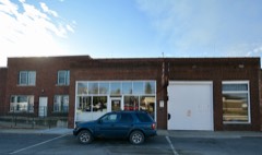 | Sankot Motor Company | building | 1995 | 95000558 |
| Shellsburg Bridge | structure | 1998 | 98000770 | |
| Upper Stone Schoolhouse | building | 1983 | 83000340 | |
 | Vinton Public Library | building | 1983 | 83000341 |
 | Youngville Cafe | building | 2007 | 06001321 |
 | Zalesky, Frank E. and Katie (Cherveny), House | building | 2012 | 12000191 |
Every wildfire the federal occurrence database records inside this county: 85 of them, burning about 1,216 acres. None started naturally and 1 was recorded as arson. Each settlement page carries the fires within five miles of it.
| Reported cause | Fires |
|---|---|
| Missing data/not specified/undetermined | 49 |
| Debris and open burning | 30 |
| Smoking | 2 |
| Equipment and vehicle use | 2 |
| Arson/incendiarism | 1 |
| Recreation and ceremony | 1 |
The five largest, by the area the report gives. None of them was recorded as arson.
| Date | Cause | Size | Reported by | Name on the report |
|---|---|---|---|---|
| 24 April 2018 | Debris and open burning | 402 acres | Port Louisa National Wildlife Refuge | CORNLAND WILDFIRE |
| 11 April 2014 | Debris and open burning | 200 acres | Iowa Department of Natural Resources | not named |
| 31 March 2015 | Debris and open burning | 160 acres | Iowa Department of Natural Resources | not named |
| 14 March 2009 | Missing data/not specified/undetermined | 50 acres | Iowa Department of Natural Resources | not named |
| 9 April 2014 | Debris and open burning | 40 acres | Iowa Department of Natural Resources | not named |
| 6 April 2014 | Debris and open burning | 40 acres | Iowa Department of Natural Resources | not named |
| 15 October 2015 | Debris and open burning | 35 acres | Iowa Department of Natural Resources | not named |
| 23 October 2011 | Missing data/not specified/undetermined | 35 acres | Iowa Department of Natural Resources | 200 BLK OF C AVE, IA |
Every settlement page carries the fires within five miles of it - see the settlement index below.
The NOAA Storm Events Database holds 752 reports for this county, causing 2 deaths, 25 injuries and about $22,491,250 in recorded property damage. Each settlement page carries the reports that name it.
| Kind of event | Reports |
|---|---|
| Thunderstorm Wind | 361 |
| Hail | 275 |
| Tornado | 46 |
| Flash Flood | 25 |
| Flood | 16 |
| Heavy Rain | 15 |
| Funnel Cloud | 13 |
| Lightning | 1 |
The most serious of them, by death, then injury, then recorded damage. The accounts are quoted exactly as the forecast office filed them.
| When | Event | Place named | Harm | What the report says |
|---|---|---|---|---|
| August 1965 | Tornado (F4) | not stated | 1 killed, 17 hurt, $2,500,000 | no account filed |
| December 2021 | Thunderstorm Wind | Walford | 1 killed | A semi-trailer was blown over during severe thunderstorm winds. The driver was thrown from the vehicle and pronounced dead at the scene. |
| July 2016 | Tornado (EF2) | Vinton | 5 hurt | A tornado tracked across the southern parts of Vinton, with damage to over a dozen homes, an apartment complex and other buildings including some roofs removed. Numerous power poles and trees were down with damage to other structures like a cell phone tower and some corn fields. |
| April 1984 | Thunderstorm Wind | not stated | 2 hurt | no account filed |
| April 2006 | Thunderstorm Wind | Van Horne | 1 hurt, $150,000 | NWS storm survey indicates a one mile wide swath of estimated 61 knot (70 mph) winds centered along 71st Street. Several outbuildings were destroyed with tree and roof damage and a tractor trailer rig was blown over. Some windows were blown out causing minor structural damage. One injury occurred with this event. A 22 year old male was hurt when the outbuilding collapsed around him. |
| June 2008 | Flood | Mt Auburn | $10,000,000 | The record crest on the Cedar River at Vinton occurred on June 12, 2008 at 24.60 feet. Flood stage is 15 feet. |
| July 2011 | Thunderstorm Wind | Garrison | $1,000,000 | Wind gusts estimated to be 120 mph caused significant damage in Garrison, IA around 455 am CDT July 11. The fire station was destroyed. The roof of the library blew off. About 80 percent of the structures in town were damaged with significant damage to about 20 percent of them. |
| July 2011 | Thunderstorm Wind | Vinton | $1,000,000 | Wind gusts estimated to be 120 mph caused significant damage throughout the town of Vinton, IA at 500 am CDT July 11. Hundreds of trees and power lines were blown down throughout the area and several cars and buildings were damaged. The Iowa Braille and Sight Saving School was heavily damaged. The Old Main building on campus will need a new roof. A smokestack at the hospital was blown off punching a gaping hole in the side of the rehabilitation center. Several buildings in Vinton sustained massive damage, including the A.S.A.C. building, Kruger's Barber Shop, the Pioneer Seed building, Mickey's Bar, Phillips funeral home and the Hummel Apartments. |
| May 2003 | Hail | Urbana | $1,000,000 | no account filed |
| July 2011 | Thunderstorm Wind | Urbana | $500,000 | Wind gusts estimated to be 80 mph ripped the roof off of the Urbana Elementary School in Urbana, IA around 510 am CDT July 11. Several other businesses were also damaged in the Becca Industrial Park, including Buresh Arch Millwork, Borlaug Systems, and PalTech Enterprises. |
| May 2003 | Hail | Keystone | $500,000 | no account filed |
| May 2003 | Hail | Garrison | $500,000 | no account filed |
| April 2003 | Hail | Urbana | $400,000 | no account filed |
| June 2010 | Flash Flood | Garrison | $250,000 | Heavy rains resulted in flash flooding of several streets in Vinton, IA and Garrison, IA during the evening of June 18. Flood waters covered Highway 218 about 3 miles south of Vinton. In addition, Hinkle Creek near Garrison was rising rapidly. |
| June 2009 | Thunderstorm Wind | Urbana | $250,000 | Wind gusts estimated to be 75 mph blew down several large trees and highway signs in Urbana, IA around 750 am June 19. Shingles were also peeled off of houses and the signs at a gas station and a bank were blown out. |
| August 2009 | Flash Flood | Garrison | $250,000 | Heavy rains of 3 to 8 inches resulted in some flash flooding across parts of Benton County on August 27. Some areas particularly hard hit were Keystone, Van Horne, Garrison, and Shellsburg. Prairie Creek experienced unprecedented flooding. It flooded an entire pasture and filled some ditches along Highway 30. Mud Creek also flooded out of its banks. Much of the area experienced standing water and some residences reported flooded basements. Several roads around Shellsburg were closed due to the flood waters flowing over roadways. |
| July 2003 | Thunderstorm Wind | Vinton | $250,000 | no account filed |
| July 2003 | Thunderstorm Wind | Mt Auburn | $250,000 | no account filed |
| August 1972 | Tornado (F1) | not stated | $250,000 | no account filed |
| May 1971 | Tornado (F3) | not stated | $250,000 | no account filed |
| July 1970 | Tornado (F1) | not stated | $250,000 | no account filed |
| April 1966 | Tornado (F3) | not stated | $250,000 | no account filed |
| July 2003 | Tornado (F1) | Vinton | $200,000 | Traveled through mainly rural areas |
| August 2004 | Thunderstorm Wind | Countywide | $150,000 | The squall line entered northwest Benton County around 1654 CST (2254 UTC) and created a consistent path of damaging winds in an east southeast direction across the northern part of the county to the Benton/Linn County line. Winds estimated at 52 knots (60 mph) occurred in Garrison during 1702-1712 CST, estimated 61 knots (70 mph) in Mt. Auburn 1708-1718 CST, Vinton 1713-1723 CST with a measured 58 knots (67 mph) at the sheriff department, and estimated 61 knots in Urbana 1732-1742 CST. Considerable damage occurred at the Vinton Airport located 3 miles north of Vinton with one hangar destroyed and another severely damaged. The damage was continuous with many corn fields flattened. In the southern part of the county wind damage was sporatic. Severe winds estimated at 52 knots (60 mph) occurred in Belle Plaine during 1702-1712 CST and Van Horne 1710-1720 CST. |
| September 2016 | Flood | Mt Auburn | $100,000 | Heavy rainfall of 4 to over 10 inches over significant areas from 21 to 23 September in extreme North Central and Northeast Iowa moved downstream causing the Cedar River to rise above major flood stage levels. ||Vinton rose above its major flood stage level of 19.0 feet on September 25th, 2016 at approximately 5 AM CST. It crested around 21.8 feet at approximately 8 AM CST on September 26th, 2016. It fell below major flood stage on September 28th around 9 AM CST.||Approximately 20 residences were inundated with water. State Highway 150 was closed at Vinton. Additional roads in the city of Vinton and secondary roads across the county were closed. |
| July 2011 | Thunderstorm Wind | Shellsburg | $100,000 | Wind gusts estimated to be 80 mph completely destroyed a metal building and blew over several roofs in Shellsburg, IA at 521 am CDT July 11. |
| August 2009 | Thunderstorm Wind | Van Horne | $100,000 | Wind gusts estimated to be 70 mph blew a 2 to 2.5 foot diameter tree down onto a house at the intersection of Highway 30 and 20th Avenue about 3 miles south southwest of Van Horne, IA around 735 pm August 9. |
| July 2008 | Tornado (EF1) | Van Horne | $100,000 | An EF1 tornado damaged a hog confinement, a barn, and some grain bins and machine sheds along a 1 mile path located about 2 to 3 miles east of Van Horne, IA around 510 pm July 2. |
| April 2003 | Hail | Urbana | $100,000 | no account filed |
| July 1995 | Thunderstorm Wind | Oskaloosa | $100,000 | no account filed |
| April 2010 | Thunderstorm Wind | Atkins | $50,000 | Wind gusts estimated to be 70 mph blew a steel roof off of a farm outbuilding, ripped the top of a silo off, and blew a barn down just north of Atkins, IA around 1012 pm April 5. |
| August 2009 | Thunderstorm Wind | Keystone | $50,000 | Wind gusts estimated to be 80 mph blew down several 1.5 foot diameter trees and 3 to 6 inch diameter tree limbs, moved and overturned some grain wagons about 100 yards, blew away some mail boxes, and ripped the doors off a house and barn about 4 miles southwest of Van Horne, IA around 745 pm August 9. |
| June 2009 | Thunderstorm Wind | Urbana | $50,000 | Wind gusts estimated to be 65 mph blew a camping trailer into a house in Urbana, IA around 730 am June 19. A semi trailer was also blown over in town. |
| May 2008 | Flash Flood | Vinton | $50,000 | Heavy rains of 2 to 5 inches resulted in flash flooding in numerous areas across Benton County during much of the morning of May 30. Highway 218 was impassible at several locations due to water flowing over the highway. Other county roads were covered with water as several area streams and creeks overflowed their banks. A motorist was rescued from the flood waters in the Garrison area after the vehicle was washed into a flooded creek. A bridge on Highway V61 north of Vinton was washed out due to the flash flooding. In particular, Hickle Creek flooded several roads in the vicinity of Vinton and caused some homes to be evacuated. Several other residences in Vinton experienced sewers backing up into their basements. The flood waters began to recede during the late morning hours. |
| June 2008 | Thunderstorm Wind | Urbana | $50,000 | Wind gusts estimated to be 70 mph damaged several Iowa DOT buildings near the intersection of Interstate 380 and Highway 150 just northwest of Urbana, IA at 2:02 am June 6. The roof was blown off of a salt shed, a pole building was partially destroyed, a wood shed was destroyed, a steel building was seriously damaged, and a brick garage was damaged. |
| May 2004 | Tornado (F1) | Atkins | $50,000 | Rated F1 with winds estimated at 110 mph. |
| July 2003 | Thunderstorm Wind | Vinton | $50,000 | Large trees down |
| July 2003 | Thunderstorm Wind | Atkins | $50,000 | 2 to 3 inch limbs down |
| July 2003 | Thunderstorm Wind | Vinton Meml Arpt | $50,000 | KVTI AWOS |
| July 2003 | Thunderstorm Wind | Mt Auburn | $50,000 | no account filed |
| July 2003 | Hail | Mt Auburn | $50,000 | no account filed |
| June 1998 | Thunderstorm Wind | Countywide | $50,000 | no account filed |
| June 1994 | Hail | Keystone to Norway | $50,000 | no account filed |
| June 1994 | Hail | Walford | $50,000 | no account filed |
| June 1994 | Thunderstorm Wind | Urbana | $50,000 | no account filed |
| July 1994 | Thunderstorm Wind | Belle Plaine | $50,000 | no account filed |
| July 1994 | Hail | Vinton | $50,000 | no account filed |
| July 1994 | Thunderstorm Wind | Vinton | $50,000 | no account filed |
| May 2017 | Thunderstorm Wind | Newhall | $25,000 | A picture was received from social media via Twitter of a roof blown off a home. |
| July 2016 | Tornado (EF1) | Norway | $25,000 | A tornado touched down southeast of Norway and tracked southeast to Walford and then into Linn County. It damaged 2 farmsteads before reaching Walford. In Walford, it damaged the roofs of numerous homes. |
| June 2012 | Thunderstorm Wind | Belle Plaine | $25,000 | Wind gusts estimated to be 70 mph blew down numerous tree limbs and power lines across the southern third of Benton County around 506 pm CDT June 29. |
| May 2011 | Thunderstorm Wind | Belle Plaine | $25,000 | Wind gusts estimated to be 70 mph destroyed the bell tower and canopy over a walkway at First Lutheran Church in Belle Plaine, IA around 450 pm CDT May 24. |
| July 2011 | Thunderstorm Wind | Vinton Meml Arpt | $25,000 | Wind gusts estimated to be 70 mph blew a semi truck off Highway 150 just north of Vinton, IA at 501 am CDT July 11. |
| July 2011 | Thunderstorm Wind | Belle Plaine | $25,000 | Wind gusts estimated to be 70 mph downed numerous trees and power lines in Belle Plaine, IA around 430 am CDT July 11. The north side of town was hardest hit. Some properties was damaged by the fallen trees. |
| July 2009 | Thunderstorm Wind | Vinton | $25,000 | Wind gusts estimated to be 70 mph blew down several large trees and limbs in Vinton, IA around 425 AM July 10. Some of the trees and branches fell on some power lines. |
| June 2008 | Thunderstorm Wind | Garrison | $25,000 | Wind gusts estimated to be 65 mph ripped off the roof of a machine shed just southeast of Garrison, IA at 1:48 am June 6. The roof was blown into some power lines causing a power outage in the area. |
| June 2008 | Thunderstorm Wind | Belle Plaine | $25,000 | Wind gusts estimated to be 70 mph ripped the roof off a house just north of Belle Plaine, IA at 1:50 am June 6. |
| June 2008 | Thunderstorm Wind | Keystone | $25,000 | Wind gusts estimated to be 70 mph blew a grain bin over in Keystone, IA at 1:42 am June 6. The grain bin struck some power lines resulting in a power outage for the area. |
| May 1995 | Hail | Newhall | $25,000 | no account filed |
| July 1995 | Thunderstorm Wind | Vinton | $25,000 | no account filed |
The Survey's mineral resources record lists 24 workings inside this county. 10 still produce and 14 are closed or unrecorded. Each settlement page carries the workings within five miles of it.
| Commodity | Workings |
|---|---|
| Stone, Crushed/Broken | 16 |
| Sand and Gravel, Construction | 5 |
| Clay | 1 |
| Stone, Crushed/Broken, Sand and Gravel, Construction | 1 |
| Limestone, Dimension | 1 |
The least common of them first, because a county's hundredth gravel pit says nothing its first ten did not.
| Where | Site | Commodity | Status | Recorded |
|---|---|---|---|---|
| Garrison Brick and Tile Works | Clay | Past Producer | ||
| Unknown | Stone, Crushed/Broken, Sand and Gravel, Construction | Past Producer | ||
| Unknown | Limestone, Dimension | Past Producer | ||
| Coots Sand Plant | Sand and Gravel, Construction | Producer | ||
| Goosie Pit | Sand and Gravel, Construction | Producer | ||
| Karr Sand and Gravel | Sand and Gravel, Construction | Producer | ||
| Unknown | Sand and Gravel, Construction | Past Producer | ||
| Vinton Sand Pit | Sand and Gravel, Construction | Producer | ||
| Aungst Brothers Quarry | Stone, Crushed/Broken | Past Producer | ||
| Ballheim Quarry | Stone, Crushed/Broken | Producer | ||
| Demmel Quarry | Stone, Crushed/Broken | Producer | ||
| Froning Quarry | Stone, Crushed/Broken | Past Producer | ||
| Garrison Quarry | Stone, Crushed/Broken | Producer | ||
| Jabens Quarry | Stone, Crushed/Broken | Past Producer | ||
| Long Quarry | Stone, Crushed/Broken | Producer | ||
| Miller Quarry | Stone, Crushed/Broken | Past Producer | ||
| Mt. Auburn Quarry | Stone, Crushed/Broken | Past Producer | ||
| Old Bliss Quarry | Stone, Crushed/Broken | Past Producer | ||
| Old Long Quarry | Stone, Crushed/Broken | Past Producer | ||
| Pork Chop Hill Quarry | Stone, Crushed/Broken | Producer | ||
| Smith Quarry | Stone, Crushed/Broken | Past Producer | ||
| Unknown | Stone, Crushed/Broken | Past Producer | ||
| Vinton Quarry | Stone, Crushed/Broken | Producer | ||
| White Quarry | Stone, Crushed/Broken | Past Producer |
Named settlements recorded in the Geographic Names Information System, each with the topographic sheets covering it. Villages, hamlets and abandoned places alike. Each is shown with the nearest named watercourse or landform and the survey quadrangle it falls on.
Benton township · 52349 · Center Point NW quadrangle
13 sheets, 1888 to 1984
No longer a settlement
Jackson township · 52229 · Garrison quadrangle
9 sheets, 1954 to 1984
No longer a settlement
Polk township · 52345 · Center Point quadrangle
14 sheets, 1888 to 1984
No longer a settlement
The vanished settlements of Benton County: the places named above that are no longer on the map.