 Block
From the record
19 National Register listings published here.
Sources: the National Register database, National Park Service
60 topographic sheets cover 21 settlements here, and 19 properties are on the National Register of Historic Places.
19 National Register listings published here.
Sources: the National Register database, National Park Service
Every property in this county listed on the National Register of Historic Places, with the year it was listed and the federal nomination document.
| Photograph | Property | Type | Listed | Reference |
|---|---|---|---|---|
 | Alonzo J. and Flora Barkley House | building | 1995 | 95000857 |
 | Beaver Creek Bridge | structure | 1998 | 98000762 |
 | Big Creek Bridge | structure | 1998 | 98000766 |
 | Big Creek Bridge 2 | structure | 1998 | 98000767 |
| Boone Bridge | structure | 98000761 | ||
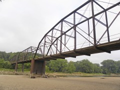 | Boone Bridge 2 | structure | 1998 | 98000765 |
 | Boone County Courthouse | building | 1981 | 81000226 |
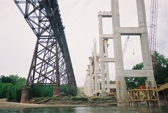 | Boone Viaduct | structure | 1978 | 78001207 |
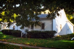 | Carl and Ulrika Dalander Cassel House | building | 1982 | 82002609 |
 | Champlin Memorial Masonic Temple | building | 1990 | 90001853 |
| Des Moines Township #7 | building | 2019 | 100004212 | |
 | Ericson Public Library | building | 1983 | 83000344 |
 | First National Bank | building | 1989 | 88003232 |
 | John H. Herman House | building | 1989 | 88003233 |
 | Perrigo-Holmes House | building | 1994 | 94001102 |
 | J. H. Riekenberg House | building | 1988 | 87002017 |
| Squaw Creek Bridge | structure | 1998 | 98000763 | |
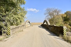 | Squaw Creek Bridge 2 | structure | 1998 | 98000764 |
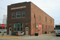 | Stoll Building Works | building | 1997 | 97000390 |
Every wildfire the federal occurrence database records inside this county: 28 of them, burning about 175 acres. None started naturally and 1 was recorded as arson. Each settlement page carries the fires within five miles of it.
| Reported cause | Fires |
|---|---|
| Missing data/not specified/undetermined | 25 |
| Debris and open burning | 2 |
| Arson/incendiarism | 1 |
The five largest, by the area the report gives. None of them was recorded as arson.
| Date | Cause | Size | Reported by | Name on the report |
|---|---|---|---|---|
| 15 March 2006 | Missing data/not specified/undetermined | 30 acres | Iowa Department of Natural Resources | not named |
| 31 October 2010 | Missing data/not specified/undetermined | 20 acres | Iowa Department of Natural Resources | 2443 HWY E-43, IOWA |
| 8 September 2009 | Missing data/not specified/undetermined | 20 acres | Iowa Department of Natural Resources | not named |
| 5 October 2011 | Missing data/not specified/undetermined | 20 acres | Iowa Department of Natural Resources | 120TH AND HWY 17 BOONE COUNTY, IA |
| 20 November 2019 | Missing data/not specified/undetermined | 18 acres | Iowa Department of Natural Resources | not named |
| 26 March 2006 | Missing data/not specified/undetermined | 15 acres | Iowa Department of Natural Resources | not named |
| 11 November 2010 | Missing data/not specified/undetermined | 10 acres | Iowa Department of Natural Resources | I AVE, OGDEN., IOWA |
| 15 March 2011 | Missing data/not specified/undetermined | 7.0 acres | Iowa Department of Natural Resources | 250TH ST. & D AVE, IA |
Every settlement page carries the fires within five miles of it - see the settlement index below.
The NOAA Storm Events Database holds 594 reports for this county, causing no deaths, 13 injuries and about $36,712,500 in recorded property damage. Each settlement page carries the reports that name it.
| Kind of event | Reports |
|---|---|
| Thunderstorm Wind | 214 |
| Hail | 194 |
| Heavy Rain | 72 |
| Tornado | 53 |
| Flash Flood | 26 |
| Flood | 20 |
| Funnel Cloud | 12 |
| Lightning | 3 |
The most serious of them, by death, then injury, then recorded damage. The accounts are quoted exactly as the forecast office filed them.
| When | Event | Place named | Harm | What the report says |
|---|---|---|---|---|
| June 1976 | Tornado (F5) | not stated | 9 hurt, $25,000,000 | no account filed |
| November 2005 | Tornado (F2) | Madrid | 2 hurt, $750,000 | Tornado moved from Dallas County into Boone County. Two injuries occurred in Woodward. |
| March 2006 | Thunderstorm Wind | Boone | 2 hurt, $50,000 | no account filed |
| March 1990 | Tornado (F2) | not stated | $2,500,000 | no account filed |
| June 1996 | Flash Flood | Boone | $400,000 | no account filed |
| November 2005 | Tornado (F1) | Boxholm | $250,000 | Tornado moved across Boone County and moved into Webster County. |
| April 2007 | Flood | Boxholm | $250,000 | no account filed |
| May 1998 | Hail | Pilot Mound | $250,000 | no account filed |
| March 1991 | Tornado (F2) | not stated | $250,000 | no account filed |
| March 1990 | Tornado (F1) | not stated | $250,000 | no account filed |
| October 1980 | Tornado (F1) | not stated | $250,000 | no account filed |
| June 1976 | Tornado (F3) | not stated | $250,000 | no account filed |
| May 1962 | Tornado (F2) | not stated | $250,000 | no account filed |
| July 2010 | Thunderstorm Wind | Boone | $200,000 | Local law enforcement reports trees and power lines down in Boone and across the county with some roads closed due to debris. |
| November 2005 | Tornado (F1) | Madrid | $200,000 | Tornado hit one home, but remained mostly in open countryside. |
| May 2004 | Flash Flood | Countywide | $200,000 | no account filed |
| April 2001 | Tornado (F1) | Ogden | $150,000 | Relatively brief touchdown, destroyed a barn. |
| June 2001 | Flash Flood | Countywide | $150,000 | no account filed |
| February 2016 | Flood | Zook Spur | $100,000 | An Emergency Manager reported flooding due to an ice jam near Fraser and in areas south of Highway 30 near the 270th Street/E57 bridge. |
| May 2012 | Thunderstorm Wind | Boone | $100,000 | The emergency manager reported that four 1 1/2 foot diameter evergreen trees were downed and the roof was torn off of a barn in the northwest corner of Boone. Also from a mile north of Boone to the eastern border of the county sheeting was strewn about from various buildings. |
| July 2010 | Thunderstorm Wind | Madrid | $100,000 | Local law enforcement reports power lines and trees down across the county. Some roads blocked by debris and a house struck by a tree on 320th about 2 miles northeast of Madrid. |
| November 2005 | Tornado (F0) | Boone | $100,000 | Tornado touched down in Boone County and moved into Story County. |
| June 2008 | Flood | Ridgeport | $100,000 | no account filed |
| June 2008 | Flood | Ridgeport | $100,000 | no account filed |
| May 2004 | Flash Flood | Countywide | $100,000 | no account filed |
| May 1998 | Hail | Boone | $100,000 | no account filed |
| June 1998 | Flood | Boone | $100,000 | no account filed |
| May 2017 | Thunderstorm Wind | Napier | $75,000 | Emergency manager reported multiple farmsteads with roofs blown off, damage to several outbuildings, a garage blown off the foundation, and power lines down. The roof and upper levels of an old corn crib were blown off, windows broken from debris blowing into the window, a garage door was ripped off the track, 6 inch diameter tree limbs were down, large trees were down blocking a road. Another large tree limb landed on a van and porch roof destroying the van and roof. |
| November 2015 | Thunderstorm Wind | Napier | $75,000 | Boone County Emergency Manager reported a 3 mile stretch of damage from 1.5 W of Napier to 3 miles NE of Napier. Damaged included roof off old grain bin, damaged barn, and a one foot diameter pine tree down. All damage was in one direction. Time estimated from radar. |
| July 2010 | Thunderstorm Wind | Boone | $75,000 | Numerous branches down across the city of Boone. Largest was at least 18 inches in diameter. |
| July 2008 | Thunderstorm Wind | Ogden | $75,000 | Numerous trees were blown down and a grain elevator blown over. |
| July 2008 | Thunderstorm Wind | Sheldahl | $75,000 | Structural damage was reported near the intersection of 320th and Violet, and 310th and Unicorn. |
| August 2007 | Flash Flood | Wolf | $75,000 | Several gravel and hard top roads were closed over northern Boone county, mainly northwest of Boone. |
| April 2001 | Tornado (F1) | Pilot Mound | $75,000 | Tracked over mainly open country. |
| March 2006 | Thunderstorm Wind | Pilot Mound | $75,000 | no account filed |
| June 1998 | Tornado (F1) | Berkley | $75,000 | no account filed |
| July 2012 | Thunderstorm Wind | Ogden | $60,000 | Emergency Manager estimated winds of 60 MPH. Central Iowa Expo building was destroyed. |
| March 2017 | Tornado (EF0) | Luther | $50,000 | Tornado began near the Des Moines River just west of Ledges State Park. This tornado tracked northeast for several miles producing mainly EF0 damage. The tornado likely had intermittent contact with the ground, especially near Jordon to the Boone/Story County line. The tornado continued into Story County. |
| August 2015 | Flash Flood | Pilot Mound | $50,000 | Emergency Manager reported Juniper Ave closed in the 100 block. Box culvert also washed out due to the flash flooding. |
| December 2015 | Flood | Ericson | $50,000 | Flooding was reported in the town of Luther with water within inches of town hall. |
| July 2011 | Thunderstorm Wind | Madrid | $50,000 | High winds tore part of the roof off of a stick built house. |
| August 2010 | Flash Flood | Boone | $50,000 | Boone County law reports numerous roads flooded in town as well as flooding along old Highway 30 at Highway 17. |
| July 2010 | Flash Flood | Ridgeport | $50,000 | Intersection of County Highways R27 and E18 closed due to flooding. Over a foot of water was reported flowing over a gravel road in the same area. Four to 5 inches of rainfall has been measured. |
| May 2008 | Heavy Rain | Boone | $50,000 | Heavy rain of 3 inches caused basement flooding in Boone. |
| June 2008 | Flash Flood | Ericson | $50,000 | Several county gravel roads were under water across southeast Boone County. |
| June 2008 | Flash Flood | Moingona | $50,000 | Extensive street flooding in Boone. Flash flooding reported at 150th and 139th St. in Boone County. |
| July 2008 | Hail | Fraser | $50,000 | Public reports baseball size hail in Fraser. |
| July 2008 | Thunderstorm Wind | Madrid | $50,000 | A barn was blown down. |
| April 1994 | Tornado (F1) | not stated | $50,000 | Thunderstorms had moved out of Iowa for the most part during the late evening hours as the dry slot advanced over the state. During the early morning hours, three other features combined to once again produce severe weather in the state. The surface dry line was advancing east across Kansas and southeast Nebraska. At the same time a strong low level jet had become established with speeds in excess of 55 kts. Above this a strong jet stream was in place in the upper levels. What is known as a speed maximum (a jet streak) rotated around the upper trough and ejected toward Iowa. This set the stage for rekindling of strong thunderstorms. At this time, moisture was much more limited so thunderstorms were more of the pulse variety and were not able to maintain their strength as in a supercell storm. Hail and winds were the trademarks of these storms. Hail of three-quarters of an inch to one inch in diameter pelted Adams and Adair Counties. Many of the other storms only produced pea- to occasional marble-size hail. One storm became quiet strong for a while. It was the southern most storm in the line. It produced 60 mph winds as it passed through both Greenfield and Corning. Another storm developed a couple hours later and moved into central Iowa. High winds blew into the west part of Ames causing damage to trees and buildings. A tornado developed on the southwest part of the storm a short time later. It tracked through the western parts of the city. It touched down near new United States Highway 30 and lifted as it crossed old Highway 30. Several buildings were damaged or destroyed. Windows were broken out on several houses and cars in the area. Power was knocked out in the area as well. |
| April 1994 | Thunderstorm Wind | Story City | $50,000 | Thunderstorms had moved out of Iowa for the most part during the late evening hours as the dry slot advanced over the state. During the early morning hours, three other features combined to once again produce severe weather in the state. The surface dry line was advancing east across Kansas and southeast Nebraska. At the same time a strong low level jet had become established with speeds in excess of 55 kts. Above this a strong jet stream was in place in the upper levels. What is known as a speed maximum (a jet streak) rotated around the upper trough and ejected toward Iowa. This set the stage for rekindling of strong thunderstorms. At this time, moisture was much more limited so thunderstorms were more of the pulse variety and were not able to maintain their strength as in a supercell storm. Hail and winds were the trademarks of these storms. Hail of three-quarters of an inch to one inch in diameter pelted Adams and Adair Counties. Many of the other storms only produced pea- to occasional marble-size hail. One storm became quiet strong for a while. It was the southern most storm in the line. It produced 60 mph winds as it passed through both Greenfield and Corning. Another storm developed a couple hours later and moved into central Iowa. High winds blew into the west part of Ames causing damage to trees and buildings. A tornado developed on the southwest part of the storm a short time later. It tracked through the western parts of the city. It touched down near new United States Highway 30 and lifted as it crossed old Highway 30. Several buildings were damaged or destroyed. Windows were broken out on several houses and cars in the area. Power was knocked out in the area as well. |
| July 2010 | Thunderstorm Wind | Ericson | $50,000 | no account filed |
| July 2008 | Thunderstorm Wind | Ogden | $50,000 | no account filed |
| July 2008 | Thunderstorm Wind | Ericson | $50,000 | no account filed |
| July 1999 | Hail | Pilot Mound | $50,000 | no account filed |
| May 1998 | Thunderstorm Wind | Boone | $50,000 | no account filed |
| June 1998 | Thunderstorm Wind | Madrid | $50,000 | no account filed |
| May 1995 | Thunderstorm Wind | Weldon | $50,000 | no account filed |
| June 1994 | Hail | Madrid | $50,000 | no account filed |
| June 1994 | Hail | Woodward | $50,000 | no account filed |
| October 1994 | Thunderstorm Wind | Ogden | $50,000 | no account filed |
The Survey's mineral resources record lists 35 workings inside this county. 4 still produce and 31 are closed or unrecorded. Each settlement page carries the workings within five miles of it.
| Commodity | Workings |
|---|---|
| Sand and Gravel, Construction | 27 |
| Clay | 8 |
The least common of them first, because a county's hundredth gravel pit says nothing its first ten did not.
| Where | Site | Commodity | Status | Recorded |
|---|---|---|---|---|
| Boone Clay Works | Clay | Past Producer | ||
| Everett Yard | Clay | Past Producer | ||
| G. Eckert Yard | Clay | Past Producer | ||
| Jacob Yegge Brickyard | Clay | Past Producer | ||
| N. W. Griffee Pottery Works | Clay | Past Producer | ||
| Slater Yard | Clay | Past Producer | ||
| Unknown | Clay | Past Producer | ||
| Unknown | Clay | Past Producer | ||
| Ahrens Pit | Sand and Gravel, Construction | Past Producer | ||
| Blancher Pit | Sand and Gravel, Construction | Past Producer | ||
| Boone Pit | Sand and Gravel, Construction | Past Producer | ||
| Colemen Pit | Sand and Gravel, Construction | Past Producer | ||
| Earl Gates | Sand and Gravel, Construction | Past Producer | ||
| Gast Pit | Sand and Gravel, Construction | Past Producer | ||
| Hollingsworth Pit | Sand and Gravel, Construction | Producer | ||
| Jensen Pit | Sand and Gravel, Construction | Producer | ||
| Jorden Pit | Sand and Gravel, Construction | Past Producer | ||
| Keeney Pit | Sand and Gravel, Construction | Past Producer | ||
| Laube Pit | Sand and Gravel, Construction | Past Producer | ||
| Maudlin Pit | Sand and Gravel, Construction | Past Producer | ||
| Mondt Pit | Sand and Gravel, Construction | Past Producer | ||
| Myers Pit | Sand and Gravel, Construction | Producer | ||
| Nystrom Pit | Sand and Gravel, Construction | Past Producer | ||
| Stumbo Pit | Sand and Gravel, Construction | Producer | ||
| Swigert Pit | Sand and Gravel, Construction | Past Producer | ||
| Unknown | Sand and Gravel, Construction | Past Producer | ||
| Unknown | Sand and Gravel, Construction | Past Producer | ||
| Unknown | Sand and Gravel, Construction | Past Producer | ||
| Unknown | Sand and Gravel, Construction | Past Producer | ||
| Unknown | Sand and Gravel, Construction | Past Producer | ||
| Unknown | Sand and Gravel, Construction | Past Producer | ||
| Unknown | Sand and Gravel, Construction | Past Producer | ||
| Unknown | Sand and Gravel, Construction | Past Producer | ||
| Unknown | Sand and Gravel, Construction | Past Producer | ||
| Unknown | Sand and Gravel, Construction | Past Producer |
Named settlements recorded in the Geographic Names Information System, each with the topographic sheets covering it. Villages, hamlets and abandoned places alike. Each is shown with the nearest named watercourse or landform and the survey quadrangle it falls on.
Yell township · 50036 · On Bass Point Creek · Boone West quadrangle
13 sheets, 1916 to 1993
Des Moines township · 50036 · On Sand Creek · Boone West quadrangle
13 sheets, 1916 to 1993