 Block
From the record
13 National Register listings published here.
Sources: the National Register database, National Park Service
22 topographic sheets cover 21 settlements here, and 13 properties are on the National Register of Historic Places.
13 National Register listings published here.
Sources: the National Register database, National Park Service
Every property in this county listed on the National Register of Historic Places, with the year it was listed and the federal nomination document.
| Photograph | Property | Type | Listed | Reference |
|---|---|---|---|---|
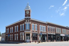 | Bank of Sumner | building | 2004 | 04000900 |
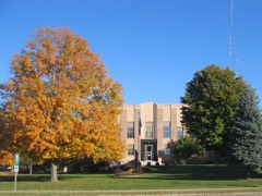 | Bremer County Court House | building | 2003 | 03000821 |
| Green Mill Ford Bridge | structure | 1998 | 98000760 | |
 | Harmon and LeValley Northwest Historic District | district | 2014 | 14000284 |
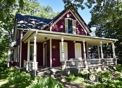 | Old Fourth Ward Southeast Historic District | district | 2013 | 13000922 |
 | Sturdevant Southwest Historic District | district | 2016 | 16000248 |
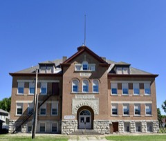 | Sumner High School | building | 2004 | 04000597 |
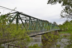 | Third Street Bridge (FHWA No. 012250) | structure | 2018 | 100002485 |
 | Wartburg College Historic District | district | 2022 | 100008031 |
 | Wartburg Teachers' Seminary | building | 1978 | 78001208 |
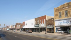 | Waverly East Bremer Avenue Commercial Historic District | district | 2014 | 14000174 |
 | Waverly House | building | 1976 | 76000735 |
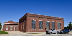 | Waverly Municipal Hydroelectric Powerhouse | building | 2026 | 13000923 |
Every wildfire the federal occurrence database records inside this county: 66 of them, burning about 1,006 acres. 1 started naturally and none was recorded as arson. Each settlement page carries the fires within five miles of it.
| Reported cause | Fires |
|---|---|
| Missing data/not specified/undetermined | 28 |
| Debris and open burning | 28 |
| Equipment and vehicle use | 8 |
| Natural | 1 |
| Smoking | 1 |
The five largest, by the area the report gives. None of them was recorded as arson.
| Date | Cause | Size | Reported by | Name on the report |
|---|---|---|---|---|
| 1 April 2015 | Debris and open burning | 500 acres | Iowa Department of Natural Resources | not named |
| 14 October 2010 | Missing data/not specified/undetermined | 80 acres | Iowa Department of Natural Resources | 2300 BLK OF MIDWAY AVE, IOWA |
| 1 April 2015 | Debris and open burning | 50 acres | Iowa Department of Natural Resources | not named |
| 13 May 2020 | Debris and open burning | 40 acres | Iowa Department of Natural Resources | not named |
| 13 May 2020 | Debris and open burning | 30 acres | Iowa Department of Natural Resources | not named |
| 4 November 2020 | Equipment and vehicle use | 30 acres | Iowa Department of Natural Resources | not named |
| 4 November 2020 | Equipment and vehicle use | 30 acres | Iowa Department of Natural Resources | not named |
| 15 March 2009 | Missing data/not specified/undetermined | 20 acres | Iowa Department of Natural Resources | not named |
Every settlement page carries the fires within five miles of it - see the settlement index below.
The NOAA Storm Events Database holds 394 reports for this county, causing no deaths, 12 injuries and about $15,845,000 in recorded property damage. Each settlement page carries the reports that name it.
| Kind of event | Reports |
|---|---|
| Thunderstorm Wind | 151 |
| Hail | 128 |
| Heavy Rain | 32 |
| Tornado | 29 |
| Flash Flood | 24 |
| Flood | 21 |
| Funnel Cloud | 5 |
| Lightning | 4 |
The most serious of them, by death, then injury, then recorded damage. The accounts are quoted exactly as the forecast office filed them.
| When | Event | Place named | Harm | What the report says |
|---|---|---|---|---|
| July 2019 | Thunderstorm Wind | Waverly | 9 hurt, $20,000 | Numerous tents on the fairgrounds were blown down with people in them causing some injuries. In another place in town a woman had a broken arm when a tree fell on her while mowing the lawn. Several trees fell across the area with some additional injuries. There was no thunderstorm in the area, as they were to the north, but the strong gust front from the storms up north produced the damage. |
| July 2019 | Thunderstorm Wind | Sumner | 2 hurt, $2,000 | Some inflatables were blown away from a town celebration. Two injuries were sustained at the town celebration from outdoor flying objects. There were no thunderstorms in the area, as they were to the north, but the strong gust front from the storms up north produced the damage. |
| May 1988 | Thunderstorm Wind | not stated | 1 hurt | no account filed |
| April 1981 | Tornado (F2) | not stated | $2,500,000 | no account filed |
| September 1961 | Tornado (F4) | not stated | $2,500,000 | no account filed |
| July 2021 | Tornado (EF2) | Babcock | $1,000,000 | The tornado moved into Bremer county from Butler county. The tornado impacted a couple of acreages just east of the county line producing EF0 and EF1 damage before weakening and becoming an intermittent funnel. The tornado destroyed 2 barns just north of the 4th street SW exit off of Highway 218. It then crossed the Cedar River just southwest Waverly doing damage to houses on both sides of the river, mostly EF0 and EF1 damage. After crossing Hilton Avenue, it intensified and produced EF2 damage with extensive tree damage along with toppling a high voltage power line. The tornado continued farther east and slowly weakened, staying mostly in open rural land. The tornado eventually lifted to the northwest of Denver. |
| July 2010 | Flash Flood | Denver | $1,000,000 | Water covered most secondary roads in Bremer County, but was receding. Numerous flooded basements across the county, but the worst hit were in the Denver and Readlyn areas. The sewer system was threatened in Readlyn and Denver pumps were running to aid the overtaxed sewer system. |
| May 1999 | Flash Flood | Waverly | $750,000 | no account filed |
| July 1994 | Thunderstorm Wind | Waverly | $500,000 | no account filed |
| June 1994 | Thunderstorm Wind | Sumner | $500,000 | no account filed |
| June 2010 | Thunderstorm Wind | Bremer | $350,000 | Three houses damaged and 2 barns down. One house was shifted on its foundation. Storm survey conclusion was these were straight line winds of about 95 MPH. |
| May 2013 | Flash Flood | Waverly | $300,000 | Several roads across the county have water over them from small creeks and streams. Flooding reported in the cities. |
| May 2013 | Flood | Babcock | $250,000 | no account filed |
| June 2008 | Flood | Plainfield | $250,000 | no account filed |
| May 1988 | Tornado (F1) | not stated | $250,000 | no account filed |
| November 1988 | Tornado (F1) | not stated | $250,000 | no account filed |
| July 1977 | Tornado (F2) | not stated | $250,000 | no account filed |
| November 1975 | Tornado (F1) | not stated | $250,000 | no account filed |
| July 1971 | Tornado (F2) | not stated | $250,000 | no account filed |
| March 2019 | Flood | Finchford | $200,000 | The county EM reported flooding of county roads across the county. |
| June 2014 | Thunderstorm Wind | Buck Creek | $200,000 | Narrow but strong area of wind damage in east central Bremer County. Worst damage was on a farmstead (point used for this event). A barn was flattened, multiple trees were snapped, and several empty grain bins were thrown into the trees. |
| April 2008 | Flood | Plainfield | $200,000 | no account filed |
| September 2005 | Thunderstorm Wind | Plainfield | $150,000 | no account filed |
| July 2018 | Flood | Plainfield | $100,000 | Water was reported over many roads in the county. |
| July 2017 | Flash Flood | Sumner | $100,000 | Law enforcement reported several houses with water flooding into basement along with numerous roads covered with water up to 1 foot in places. At least one person reported as being evacuated from their home. |
| September 2016 | Flood | Waverly | $100,000 | Law enforcement reported all of the southeast portion of Waverly has been evacuated due to the Cedar River flooding. Time of evacuation unknown. |
| April 2008 | Flash Flood | Waverly | $100,000 | Roads were washed out in various parts of the county. |
| April 2008 | Flash Flood | Denver | $100,000 | Part of the town was being evacuated due to flooding. |
| September 2001 | Tornado (F2) | Waverly | $100,000 | Tornado moved in from Butler County and touched down again, mostly in open field. A car and garage was damaged in Bremer County. |
| May 2004 | Flash Flood | Countywide | $100,000 | no account filed |
| June 1997 | Thunderstorm Wind | Tripoli | $100,000 | no account filed |
| April 1997 | Thunderstorm Wind | Plainfield | $100,000 | no account filed |
| August 2007 | Thunderstorm Wind | Plainfield | $75,000 | High winds blew the roof off of a convenience store. The roof flew one block, shearing off power poles and knocking out power to entire town. Trees were blown down on houses in Plainfield. Trees and power poles were down just west of Plainfield. |
| August 2007 | Thunderstorm Wind | Plainfield | $75,000 | Numerous trees were blown down along highway 218 from the Chickasaw/Bremer County line, south through at least Plainfield. Trees were blown down on roads and some homes. Power poles were also blown down on roads. Large areas were without electricity. a few barns were also blown down. |
| July 1999 | Flash Flood | Waverly | $75,000 | no account filed |
| July 1995 | Hail | Plainfield | $60,000 | no account filed |
| June 2018 | Flood | Frederika | $50,000 | Minor flooding was reported along the Wapsipinicon River throughout the county and especially at Tripoli and along portions of the East Fork Wapsipinicon River throughout the county. |
| September 2018 | Flood | Janesville | $50,000 | Emergency management reported multiple road closures due to standing or running water over the roadways. Creeks across much of the county were overwhelmed with flooded fields as well. The Bremer County dispatch also noted closures at 200th and Hawthorne, 130th and Midway, 310th and Morgan, 1900 block of Marquis Rd, 200 block of 200th St. and 150th and Dakota. |
| July 2017 | Flash Flood | Sumner | $50,000 | Emergency manager reported up to a dozen evacuations from high water around the Sumner area. Multiple road closures as well. |
| July 2017 | Flash Flood | Sumner | $50,000 | Emergency manager reported total evacuations in Sumner now. Numerous roads continue to be underwater. Electrical power in Sumner has been interrupted as well. |
| July 2016 | Thunderstorm Wind | Plainfield | $50,000 | Trained spotter reported numerous trees down and uprooted. A large grain bin was pushed several feet onto the railroad tracks. Large trash dumpsters were also tipped over. |
| September 2016 | Flood | Plainfield | $50,000 | Law enforcement reported street flooding along 130th in Plainfield, along with several other roads in the Plainfield area. |
| September 2016 | Flood | Frederika | $50,000 | Iowa DOT reported US Highway 63 closed to southbound traffic due to flooding. Detour in place. |
| June 2015 | Thunderstorm Wind | Janesville | $50,000 | Emergency Manager reported a tree uprooted and on a house in town. Many large limbs down throughout the county. |
| June 2010 | Thunderstorm Wind | Tripoli | $50,000 | Damage was done to a home by microburst straight line winds estimated at 95 MPH. |
| June 2010 | Thunderstorm Wind | Sumner | $50,000 | Thunderstorm winds estimated between 80 and 90 MPH by survey team. |
| June 2010 | Thunderstorm Wind | Tripoli | $50,000 | Straight line microburst destroyed an old barn with winds estimated at 100 MPH. |
| August 2010 | Flash Flood | Waverly | $50,000 | Water up to the top of tires on vehicles located at the intersection of 3rd Ave and 4th Street in northwest Waverly. |
| July 2009 | Thunderstorm Wind | Waverly | $50,000 | Extensive crop damage was reported northwest of Waverly. |
| June 2008 | Thunderstorm Wind | Janesville | $50,000 | At the high school in Janesville, the roof of the softball dugout was ripped off and parts were wrapped around a light pole. The fence was blown over. |
| March 2010 | Flood | Plainfield | $50,000 | no account filed |
| May 2008 | Thunderstorm Wind | Waverly | $50,000 | no account filed |
| July 2000 | Flash Flood | Countywide | $50,000 | no account filed |
| June 1998 | Flood | Waverly | $50,000 | no account filed |
| June 1998 | Flood | Waverly | $50,000 | no account filed |
| July 1994 | Thunderstorm Wind | Plainfield | $50,000 | no account filed |
| August 1994 | Hail | Sumner | $50,000 | no account filed |
| June 1994 | Thunderstorm Wind | Sumner | $50,000 | no account filed |
| June 2009 | Thunderstorm Wind | Tripoli | $40,000 | Large trees were downed with 2 barns destroyed. |
| May 1998 | Thunderstorm Wind | Sumner | $40,000 | no account filed |
The Survey's mineral resources record lists 37 workings inside this county. 3 still produce and 34 are closed or unrecorded. Each settlement page carries the workings within five miles of it.
| Commodity | Workings |
|---|---|
| Sand and Gravel, Construction | 28 |
| Stone, Crushed/Broken | 8 |
| Barium-Barite | 1 |
The least common of them first, because a county's hundredth gravel pit says nothing its first ten did not.
| Where | Site | Commodity | Status | Recorded |
|---|---|---|---|---|
| Occurrence | Barium-Barite | Past Producer | Barite | |
| Drappe Quarry | Stone, Crushed/Broken | Past Producer | ||
| Foelske Quarry & Mill | Stone, Crushed/Broken | Producer | ||
| Frederika Quarry | Stone, Crushed/Broken | Producer | ||
| Shield Quarry | Stone, Crushed/Broken | Past Producer | ||
| Unknown | Stone, Crushed/Broken | Past Producer | ||
| Unknown | Stone, Crushed/Broken | Past Producer | ||
| Unknown | Stone, Crushed/Broken | Past Producer | ||
| Unknown | Stone, Crushed/Broken | Past Producer | ||
| Brandt-St Pit | Sand and Gravel, Construction | Past Producer | ||
| Dix Pit | Sand and Gravel, Construction | Past Producer | ||
| Harms Pit | Sand and Gravel, Construction | Past Producer | ||
| Janesville Pit | Sand and Gravel, Construction | Past Producer | ||
| Nolte Pit | Sand and Gravel, Construction | Producer | ||
| Oran Pit | Sand and Gravel, Construction | Past Producer | ||
| Unknown | Sand and Gravel, Construction | Past Producer | ||
| Unknown | Sand and Gravel, Construction | Unknown | ||
| Unknown | Sand and Gravel, Construction | Past Producer | ||
| Unknown | Sand and Gravel, Construction | Unknown | ||
| Unknown | Sand and Gravel, Construction | Past Producer | ||
| Unknown | Sand and Gravel, Construction | Past Producer | ||
| Unknown | Sand and Gravel, Construction | Unknown | ||
| Unknown | Sand and Gravel, Construction | Unknown | ||
| Unknown | Sand and Gravel, Construction | Unknown | ||
| Unknown | Sand and Gravel, Construction | Past Producer | ||
| Unknown | Sand and Gravel, Construction | Past Producer | ||
| Unknown | Sand and Gravel, Construction | Unknown | ||
| Unknown | Sand and Gravel, Construction | Unknown | ||
| Unknown | Sand and Gravel, Construction | Unknown | ||
| Unknown | Sand and Gravel, Construction | Past Producer | ||
| Unknown | Sand and Gravel, Construction | Past Producer | ||
| Unknown | Sand and Gravel, Construction | Unknown | ||
| Unknown | Sand and Gravel, Construction | Past Producer | ||
| Unknown | Sand and Gravel, Construction | Past Producer | ||
| Unknown | Sand and Gravel, Construction | Past Producer | ||
| Unknown | Sand and Gravel, Construction | Unknown | ||
| Unknown | Sand and Gravel, Construction | Past Producer |
Named settlements recorded in the Geographic Names Information System, each with the topographic sheets covering it. Villages, hamlets and abandoned places alike. Each is shown with the nearest named watercourse or landform and the survey quadrangle it falls on.
Frederika township · 50676 · On East Fork Wapsipinicon River · Tripoli quadrangle
9 sheets, 1954 to 1984
Jackson township · 50647 · On Klock Creek · Shell Rock quadrangle
9 sheets, 1954 to 1984