 Block
From the record
8 National Register listings published here.
Sources: the National Register database, National Park Service
16 topographic sheets cover 11 settlements here, and 8 properties are on the National Register of Historic Places.
8 National Register listings published here.
Sources: the National Register database, National Park Service
Every property in this county listed on the National Register of Historic Places, with the year it was listed and the federal nomination document.
| Photograph | Property | Type | Listed | Reference |
|---|---|---|---|---|
 | Boughton, Lemuel C. and Mary (Vaughn), House | building | 2019 | 100004428 |
 | Cherokee Commercial Historic District | district | 2005 | 05000903 |
 | Cherokee Public Library | building | 1985 | 85000773 |
 | Gillette, Guy M. and Rose (Freeman), House | building | 2019 | 100004427 |
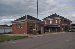 | Illinois Central Railroad Yard-Cherokee | district | 1990 | 90001308 |
 | Lewis Hotel | building | 1997 | 97000963 |
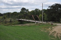 | Mill Creek Bridge | structure | 1998 | 98000811 |
 | Seaman, Roy C. and Lena (Johnson), House | building | 2019 | 100004429 |
Every wildfire the federal occurrence database records inside this county: 115 of them, burning about 1,198 acres. None started naturally and none was recorded as arson. Each settlement page carries the fires within five miles of it.
| Reported cause | Fires |
|---|---|
| Debris and open burning | 46 |
| Missing data/not specified/undetermined | 40 |
| Equipment and vehicle use | 23 |
| Smoking | 4 |
| Misuse of fire by a minor | 1 |
| Other causes | 1 |
The five largest, by the area the report gives. None of them was recorded as arson.
| Date | Cause | Size | Reported by | Name on the report |
|---|---|---|---|---|
| 29 September 2011 | Missing data/not specified/undetermined | 200 acres | Iowa Department of Natural Resources | SEC. 27 - CHEROKEE COUNTY, IA |
| 23 April 2009 | Missing data/not specified/undetermined | 160 acres | Iowa Department of Natural Resources | not named |
| 16 March 2015 | Debris and open burning | 80 acres | Iowa Department of Natural Resources | not named |
| 15 October 2015 | Equipment and vehicle use | 75 acres | Iowa Department of Natural Resources | not named |
| 6 April 2008 | Missing data/not specified/undetermined | 65 acres | Iowa Department of Natural Resources | not named |
| 15 October 2015 | Equipment and vehicle use | 45 acres | Iowa Department of Natural Resources | not named |
| 29 September 2011 | Missing data/not specified/undetermined | 40 acres | Iowa Department of Natural Resources | APPROX 12 SOUTH AND 1 EAST OF MARCUS, IA |
| 4 April 2015 | Equipment and vehicle use | 40 acres | Iowa Department of Natural Resources | not named |
Every settlement page carries the fires within five miles of it - see the settlement index below.
The NOAA Storm Events Database holds 382 reports for this county, causing no deaths, 4 injuries and about $14,553,030 in recorded property damage. Each settlement page carries the reports that name it.
| Kind of event | Reports |
|---|---|
| Hail | 163 |
| Thunderstorm Wind | 117 |
| Flood | 37 |
| Tornado | 29 |
| Flash Flood | 25 |
| Heavy Rain | 6 |
| Funnel Cloud | 4 |
| Lightning | 1 |
The most serious of them, by death, then injury, then recorded damage. The accounts are quoted exactly as the forecast office filed them.
| When | Event | Place named | Harm | What the report says |
|---|---|---|---|---|
| June 1952 | Tornado (F4) | not stated | 4 hurt, $2,500,000 | no account filed |
| March 2019 | Flood | Washta | $3,390,000 | Flooding resulted in extensive damage to public infrastructure including numerous county and township roads, culverts, and some bridges. |
| June 1984 | Tornado (F2) | not stated | $2,500,000 | no account filed |
| June 2024 | Flood | Washta | $1,020,000 | Rainfall amounts across Cherokee County from June 20-22 ranged from around a quarter of an inch across southern areas to around 2 inches across northern areas. Farther north and upstream, 5 to 10 inches of rain fell across portions of northwest Iowa. This rainfall resulted in moderate to record flooding along the Little Sioux River and Mill Creek and overland flooding along the adjoining flood plain.||The majority of flood damage occurred in or around the city of Cherokee. A total of 140 residences were impacted by flood water. Of those, 45 received major damage while 22 were completely destroyed. There were also 10 businesses that received major damage or were destroyed. Spring Lake Park was severely damaged, including a washed out road, washed out campgrounds, and a flooded yacht club. At one point, 8 bridges around Cherokee were closed and other county roads and bridges were temporarily closed. Preliminary damage assessments estimate loss to public infrastructure to be 1.02 million dollars.||For additional information on river flooding, please see other flood entries for Cherokee County. |
| December 2021 | Tornado (EF1) | Aurelia | $1,000,000 | The tornado spun up 7 miles south-southwest of Aurelia just west of the intersection of T Avenue and 610th Street. The tornado moved either northeast or north-northeast along its track and exited Cherokee County at 1707CST near the intersection of 510th Street and 10th Avenue. The tornado continued northeast and lifted one mile south of the Buena Vista County Conservation Park at 1712CST. ||Shortly after touchdown, the tornado partially collapsed the roof on a hog confinement which killed 13 hogs. Debris from this building was strewn for one to two miles to the northeast. On a northeastward track, another animal confinement farm was struck by the tornado after a couple minutes which resulted in loss of several roof panels on multiple buildings. At this point the tornado shifted path toward more of a north-northeast direction and moved into Aurelia. A drying unit was removed from the top of a grain elevator on the south edge of town. Most of the damage throughout the eastern half of Aurelia was snapped trees, which caused collateral damage to numerous roofs and windows along the path. The tornado moved through the golf course snapping and uprooting numerous trees. The tornado continued with a shift to a more northeast track, and destroyed a barn and three outbuildings along 535th Street northeast of Aurelia. Additional damage occurred to a machine shed and large trees along the Cherokee and Buena Vista County line. The tornado was rated EF1 in both Cherokee and Buena Vista Counties. The average path width was 150 yards in Cherokee County and the maximum estimated wind speed was 110 mph. Property damage costs are a rough estimate. |
| June 2014 | Flood | Larrabee | $1,000,000 | Persistent heavy rains caused major flooding of the Little Sioux River. Much farmland, other lowlands, and roads near the river were flooded. Flooded and closed roads in the town of Cherokee included Main Street and U. S. Highway 59. Several homes and businesses were flooded, especially in basements. The river crested at 8.55 feet above flood stage at Cherokee on June 19th. |
| May 2013 | Flash Flood | Aurelia | $500,000 | Widespread heavy rainfall of up to 9 inches caused flash flooding which was also widespread, affecting especially the eastern half of the county. There was significant flooding of numerous streets and homes, with many homes and businesses in the city of Cherokee affected by basement or lower level flooding. Some basements were nearly full of water. In rural areas, numerous roads, fields, and homes were flooded. |
| August 1994 | Hail | Cherokee | $500,000 | no account filed |
| December 2021 | Tornado (EF1) | Larrabee | $250,000 | This tornado formed on the southeast fringes of Larrabee, just south of 455th Street. As the tornado crossed 455th Street, it quickly destroyed four silos, a shed and a chicken barn. The tornado traveled northeast over open fields before a few trees were snapped and the east wall of a barn was pulled away along R Avenue just south of 430th Street. The tornado exited Cherokee County around 4 miles south of Sutherland, one-half mile east of the intersection of Tyler Avenue and 420th Street. The tornado continued in O'Brien County for almost 4 miles before dissipating two miles southeast of Sutherland at 1711CST. The tornado was rated EF1 while in both Cherokee County and O'Brien County. The average path width in Cherokee County was 50 yards and the maximum estimated wind speed was 105 mph. Property damage costs are a rough estimate. |
| July 2010 | Thunderstorm Wind | Cherokee | $200,000 | Thunderstorm winds caused widespread tree damage, including several large trees blown down. Several homes and businesses were damaged by falling trees, and other had shingle and other roof damage. Several vehicles were also damaged by falling trees and tree debris. A storage shed full of sports equipment at the high school was destroyed, with the equipment damaged. Signs and power lines were blown down, and a power outage resulted. A semi was blown over near town. |
| August 2006 | Thunderstorm Wind | Meriden | $200,000 | Thunderstorm winds destroyed the Maryhill Catholic Church, a structure which had stood since being rebuilt in 1905 after a lightning strike and fire. The winds also blew a hog shed 200 yards off its foundation, blew down or uprooted several large trees, and blew down power lines. |
| August 2002 | Flash Flood | Cherokee | $200,000 | Heavy rain amounting to over four inches caused flooding of roads and basements. Maple creek rose out of its banks and up to the bottom of a bridge on Iowa Highway Seven. |
| April 2011 | Tornado (EF1) | Quimby | $100,000 | A tornado snapped and damaged power poles and lines, destroyed or damaged several outbuildings on two farmsteads, flipped over a camper into a garage, damaging the garage, flipped over a large anchored empty tank, damaged the roof of a house and broke windows on the house, heavily damaged several buildings in a livestock confinement area, blew a grain bin off its foundation into a semi truck cab, flipped another semi trailer into a grain bin, and caused tree damage, including several trees blown down or snapped off. |
| June 2010 | Flood | Larrabee | $100,000 | Heavy rain caused moderate to record flooding along the Little Sioux River, with lowlands including land and several roads near the river flooded. Several roads were flooded on the south side of the town of Cherokee, including U.S. Highway 59 which was under much water, the state Highway 3 bypass, and several other roads. Up to 200 people were evacuated from the south side of Cherokee, where several businesses were flooded, and where access was cut off to areas not flooded. The river rose very rapidly and crested at a record 10.3 feet above flood stage at Cherokee on June 27th, which was the day after the flooding began. |
| July 1998 | Thunderstorm Wind | Cherokee | $100,000 | no account filed |
| December 2021 | Thunderstorm Wind | Marcus | $50,000 | Thunderstorm winds removed sections of the roof off a few buildings and blew a semi-truck off the road. Property damage costs are a rough estimate. |
| June 2014 | Flood | Marcus | $50,000 | Persistent moderate to heavy rain caused flooding of fields and other lowlands, including several roads, homes, and businesses. This flooding lasted for almost two days, and was aggravated locally by additional storms during that time. Some roads were damaged or washed out. |
| May 2013 | Flood | Larrabee | $50,000 | Heavy rain caused major to record flooding of the Little Sioux River. Farmland, parkland, and the basements or lower levels of numerous homes and several businesses were flooded. Several main roads and numerous secondary roads were flooded by the river. Main roads flooded included United States Highway 59 and Iowa Highway 3. Much of the area affected by the river flooding had also been affected by flash flooding more directly associated with the heavy rains. The river crested at a record 10.9 feet above flood stage at Cherokee on May 27th. |
| August 2000 | Thunderstorm Wind | Cleghorn | $50,000 | Thunderstorm winds caused power line and tree damage, including a 30 to 40 foot tall tree snapped at its base. Corn was flattened, but the amount of crop damage was not determined. |
| September 1997 | Thunderstorm Wind | Washta | $50,000 | no account filed |
| August 1994 | Hail | Larrabee | $50,000 | no account filed |
| July 1994 | Thunderstorm Wind | Cleghorn | $50,000 | no account filed |
| June 1994 | Hail | Marcus | $50,000 | no account filed |
| June 1994 | Hail | Marcus | $50,000 | no account filed |
| June 1994 | Hail | Cherokee | $50,000 | no account filed |
| June 1994 | Hail | Cherokee | $50,000 | no account filed |
| December 2021 | Thunderstorm Wind | Aurelia | $30,000 | Thunderstorm winds resulted in failure of garage doors, with removal of walls and roof of half the building. Debris was thrown north and northwest into several homes. Property damage costs are a rough estimate. |
| December 2021 | Thunderstorm Wind | Meriden | $30,000 | Thunderstorms winds removed a portion of the roof of a well-built machine shed. Property damage costs are a rough estimate. |
| December 2021 | Thunderstorm Wind | Aurelia | $30,000 | Thunderstorm winds blew in the south facing doors of a metal shed, which caused complete removal of the roof. Property damage costs are a rough estimate. |
| July 2010 | Flash Flood | Cherokee | $30,000 | Heavy rain caused flash flooding of numerous streets in the town of Cherokee. Basements and parkland were also flooded. |
| August 1991 | Tornado (F2) | not stated | $25,000 | no account filed |
| August 1985 | Tornado (F1) | not stated | $25,000 | no account filed |
| September 1983 | Tornado (F1) | not stated | $25,000 | no account filed |
| August 1980 | Tornado (F1) | not stated | $25,000 | no account filed |
| April 1958 | Tornado (F2) | not stated | $25,000 | no account filed |
| December 2021 | Thunderstorm Wind | Aurelia | $20,000 | A half-dozen power poles were snapped off at the ground by thunderstorm winds. Property damage costs are a rough estimate. |
| June 2003 | Thunderstorm Wind | Washta | $20,000 | Thunderstorm winds caused tree damage, including up to four inch diameter trees blown down. Minor damage to homes also occurred. |
| June 2003 | Lightning | Cherokee | $20,000 | Lightning caused a house fire which damaged the roof and ceiling of a home. |
| June 2001 | Thunderstorm Wind | Cherokee | $20,000 | Thunderstorm winds caused tree and power line damage, resulting in power outages. Several trees were blown completely down, including one which damaged the porch of a house. |
| December 2021 | Thunderstorm Wind | Mary Hill | $15,000 | Thunderstorm winds knocked down a machine shed. Property damage costs are a rough estimate. |
| October 2015 | Tornado (EF0) | Larrabee | $10,000 | A brief tornado tore most of the roof off a house. |
| October 2013 | Tornado (EF1) | Washta | $10,000 | A tornado, crossing into Chrerokee County from Woodbury County, damaged power poles, power lines, and trees. |
| June 2013 | Thunderstorm Wind | Cherokee | $10,000 | Thunderstorm winds caused tree damage, including large limbs blown down. The winds also blew down power lines. |
| September 2012 | Thunderstorm Wind | Cherokee | $10,000 | Thunderstorm winds caused tree damage and blew down power lines. |
| June 2011 | Flash Flood | Marcus | $10,000 | Heavy rain caused flash flooding of many paved and gravel roads. The floodwaters washed out a culvert and also washed a pickup truck off a road. |
| August 2000 | Thunderstorm Wind | Marcus | $10,000 | Thundestorm winds caused tree damage, including large trees blown down. |
| May 1998 | Thunderstorm Wind | Cherokee | $10,000 | no account filed |
| May 2012 | Thunderstorm Wind | Quimby | $5,000 | Thunderstorm winds destroyed a lean-to shed, blew away shingles, and caused tree damage, including the top of one tree blown down. |
| July 2001 | Thunderstorm Wind | Quimby | $5,000 | Thunderstorm winds caused tree damage and tossed patio furniture. |
| June 1994 | Hail | Larrabee | $5,000 | A cold front moved southeast out of the Dakotas into Iowa during the late afternoon and evening hours. Parameters for severe weather were weak. The instability was there, but moisture, inflow, and shear were marginal. A mesoscale convective system developed over Minnesota during the afternoon hours. As the evening progressed, the storms developed toward the southwest. Eventually the complex overspread about the northeast two thirds of Iowa. Some severe weather was reported with the storms, but it was limited. Dime-size hail fell in the northwest counties of the state. In O'Brien County, golf ball-size hail fell at Sheldon. Some roof damage was reported there. Hail damage to property was minor, however many crops were damaged. Gusty winds were common with the storms, but there were few wind gusts reaching severe criteria. Minor damage was reported in Spencer as winds clocked at 60 mph blew through the city. |
| June 1994 | Hail | Cherokee | $5,000 | no account filed |
| June 1994 | Thunderstorm Wind | Marcus | $5,000 | no account filed |
| April 2011 | Thunderstorm Wind | Quimby | $3,000 | Thunderstorm winds damaged outbuildings and a shelterbelt on a farmstead. |
| July 1987 | Tornado (F0) | not stated | $2,500 | no account filed |
| March 1963 | Tornado (F2) | not stated | $2,500 | no account filed |
| April 1968 | Tornado (F1) | not stated | $30 | no account filed |
| March 2025 | Thunderstorm Wind | Cleghorn | - | A 63 mph thunderstorm outflow wind gust was measured by a personal weather station. |
| June 2025 | Hail | Fielding | - | There was a brief period of pea to nickel size hail. |
| July 2025 | Thunderstorm Wind | Cleghorn | - | Thunderstorm winds downed large trees on a farmstead. |
| July 2025 | Thunderstorm Wind | Meriden | - | Large trees were snapped and uprooted by thunderstorm wind gusts. |
The Survey's mineral resources record lists 86 workings inside this county. 20 still produce and 66 are closed or unrecorded. Each settlement page carries the workings within five miles of it.
| Commodity | Workings |
|---|---|
| Sand and Gravel, Construction | 86 |
The least common of them first, because a county's hundredth gravel pit says nothing its first ten did not.
| Where | Site | Commodity | Status | Recorded |
|---|---|---|---|---|
| Backhaus Pit | Sand and Gravel, Construction | Producer | ||
| Bainbridge Pit | Sand and Gravel, Construction | Past Producer | ||
| Boothby Pit | Sand and Gravel, Construction | Past Producer | ||
| Bugh Pit | Sand and Gravel, Construction | Past Producer | ||
| Bugh Pit | Sand and Gravel, Construction | Past Producer | ||
| Cherokee Brewer Pit and Plant | Sand and Gravel, Construction | Producer | ||
| Cherokee County Hwy Dept | Sand and Gravel, Construction | Past Producer | ||
| Cherokee County Pits | Sand and Gravel, Construction | Producer | ||
| Cherokee Pit | Sand and Gravel, Construction | Past Producer | ||
| Cherokee Pit | Sand and Gravel, Construction | Producer | ||
| Clark Pit | Sand and Gravel, Construction | Producer | ||
| Corbett Pit | Sand and Gravel, Construction | Past Producer | ||
| Ext Brewer Pit | Sand and Gravel, Construction | Producer | ||
| Galva | Sand and Gravel, Construction | Producer | ||
| Hyndman and Freeman | Sand and Gravel, Construction | Past Producer | ||
| Jones Pit | Sand and Gravel, Construction | Past Producer | ||
| Julius Pit | Sand and Gravel, Construction | Past Producer | ||
| Killam Pit | Sand and Gravel, Construction | Producer | ||
| King Pit | Sand and Gravel, Construction | Past Producer | ||
| Larabee | Sand and Gravel, Construction | Producer | ||
| Lundell Const | Sand and Gravel, Construction | Past Producer | ||
| Lundsgaard | Sand and Gravel, Construction | Past Producer | ||
| Maudlin Const Co | Sand and Gravel, Construction | Past Producer | ||
| Maudlin Const Co | Sand and Gravel, Construction | Producer | ||
| Maudlin Const Co | Sand and Gravel, Construction | Producer | ||
| Maudlin Const Co | Sand and Gravel, Construction | Producer | ||
| Mauer | Sand and Gravel, Construction | Past Producer | ||
| Meyler Paul Pit | Sand and Gravel, Construction | Past Producer | ||
| Miller Pit | Sand and Gravel, Construction | Producer | ||
| Montgomery Pit | Sand and Gravel, Construction | Past Producer | ||
| Nelson | Sand and Gravel, Construction | Past Producer | ||
| Nelson Pit | Sand and Gravel, Construction | Producer | ||
| P F Pinkerton | Sand and Gravel, Construction | Past Producer | ||
| Peterson Pit | Sand and Gravel, Construction | Past Producer | ||
| Peterson Pit | Sand and Gravel, Construction | Past Producer | ||
| Quimby | Sand and Gravel, Construction | Producer | ||
| Rogers Pit | Sand and Gravel, Construction | Past Producer | ||
| Rohlfsen Gravel Co | Sand and Gravel, Construction | Past Producer | ||
| Shea Sand and Gravel Co | Sand and Gravel, Construction | Past Producer | ||
| Steele Pit | Sand and Gravel, Construction | Producer | ||
| Unknown | Sand and Gravel, Construction | Past Producer | ||
| Unknown | Sand and Gravel, Construction | Past Producer | ||
| Unknown | Sand and Gravel, Construction | Past Producer | ||
| Unknown | Sand and Gravel, Construction | Unknown | ||
| Unknown | Sand and Gravel, Construction | Producer | ||
| Unknown | Sand and Gravel, Construction | Past Producer | ||
| Unknown | Sand and Gravel, Construction | Past Producer | ||
| Unknown | Sand and Gravel, Construction | Past Producer | ||
| Unknown | Sand and Gravel, Construction | Past Producer | ||
| Unknown | Sand and Gravel, Construction | Past Producer | ||
| Unknown | Sand and Gravel, Construction | Past Producer | ||
| Unknown | Sand and Gravel, Construction | Past Producer | ||
| Unknown | Sand and Gravel, Construction | Past Producer | ||
| Unknown | Sand and Gravel, Construction | Past Producer | ||
| Unknown | Sand and Gravel, Construction | Past Producer | ||
| Unknown | Sand and Gravel, Construction | Past Producer | ||
| Unknown | Sand and Gravel, Construction | Past Producer | ||
| Unknown | Sand and Gravel, Construction | Past Producer | ||
| Unknown | Sand and Gravel, Construction | Past Producer | ||
| Unknown | Sand and Gravel, Construction | Past Producer | ||
| Unknown | Sand and Gravel, Construction | Past Producer | ||
| Unknown | Sand and Gravel, Construction | Past Producer | ||
| Unknown | Sand and Gravel, Construction | Past Producer | ||
| Unknown | Sand and Gravel, Construction | Past Producer | ||
| Unknown | Sand and Gravel, Construction | Past Producer | ||
| Unknown | Sand and Gravel, Construction | Past Producer | ||
| Unknown | Sand and Gravel, Construction | Past Producer | ||
| Unknown | Sand and Gravel, Construction | Past Producer | ||
| Unknown | Sand and Gravel, Construction | Producer | ||
| Unknown | Sand and Gravel, Construction | Past Producer | ||
| Unknown | Sand and Gravel, Construction | Past Producer | ||
| Unknown | Sand and Gravel, Construction | Past Producer | ||
| Unknown | Sand and Gravel, Construction | Past Producer | ||
| Unknown | Sand and Gravel, Construction | Past Producer | ||
| Unknown | Sand and Gravel, Construction | Past Producer | ||
| Unknown | Sand and Gravel, Construction | Past Producer | ||
| Unknown | Sand and Gravel, Construction | Past Producer | ||
| Unknown | Sand and Gravel, Construction | Past Producer | ||
| Unknown | Sand and Gravel, Construction | Past Producer | ||
| Voltmer Pit | Sand and Gravel, Construction | Past Producer | ||
| Washta | Sand and Gravel, Construction | Producer |
Named settlements recorded in the Geographic Names Information System, each with the topographic sheets covering it. Villages, hamlets and abandoned places alike. Each is shown with the nearest named watercourse or landform and the survey quadrangle it falls on.
Cherokee township · 51012 · On Railroad Creek · Cherokee South quadrangle
9 sheets, 1954 to 1985
Pilot township · 51012 · On Coonley Creek · Cherokee South quadrangle
9 sheets, 1954 to 1985