 Block
From the record
8 National Register listings published here.
Sources: the National Register database, National Park Service
25 topographic sheets cover 14 settlements here, and 8 properties are on the National Register of Historic Places.
8 National Register listings published here.
Sources: the National Register database, National Park Service
Every property in this county listed on the National Register of Historic Places, with the year it was listed and the federal nomination document.
| Photograph | Property | Type | Listed | Reference |
|---|---|---|---|---|
 | J. V. Banta House | building | 1983 | 83000348 |
 | Chicago, Burlington and Quincy Depot | building | 2009 | 08001283 |
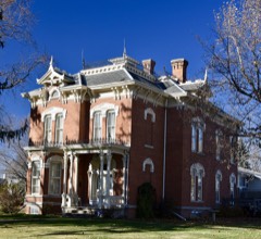 | Cowles, George H and Alice Spaulding, House | building | 2006 | 06001161 |
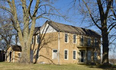 | John and Mary Jane Kyte Farmstead District | district | 2000 | 00001074 |
 | Osceola Commercial Historic District | district | 2018 | 100001971 |
| Osceola Masonic Block | building | 2010 | 10000421 | |
 | Temple, Marcellus Luther and Julia Protzman, House | building | 1996 | 96000361 |
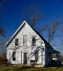 | Dickinson Webster House | building | 1977 | 77000501 |
Every wildfire the federal occurrence database records inside this county: 16 of them, burning about 477 acres. None started naturally and none was recorded as arson. Each settlement page carries the fires within five miles of it.
| Reported cause | Fires |
|---|---|
| Debris and open burning | 7 |
| Missing data/not specified/undetermined | 7 |
| Railroad operations and maintenance | 1 |
| Smoking | 1 |
The five largest, by the area the report gives. None of them was recorded as arson.
| Date | Cause | Size | Reported by | Name on the report |
|---|---|---|---|---|
| 5 April 2011 | Missing data/not specified/undetermined | 300 acres | Iowa Department of Natural Resources | 110TH AVE MURRAY IA, IA |
| 12 February 2006 | Missing data/not specified/undetermined | 75 acres | Iowa Department of Natural Resources | not named |
| 13 March 2015 | Railroad operations and maintenance | 40 acres | Iowa Department of Natural Resources | not named |
| 6 October 2020 | Debris and open burning | 26 acres | Iowa Department of Natural Resources | not named |
| 4 April 2013 | Debris and open burning | 10 acres | Iowa Department of Natural Resources | not named |
| 1 March 2020 | Debris and open burning | 10 acres | Iowa Department of Natural Resources | not named |
| 6 March 2020 | Debris and open burning | 3.0 acres | Iowa Department of Natural Resources | not named |
| 27 February 2006 | Missing data/not specified/undetermined | 3.0 acres | Iowa Department of Natural Resources | not named |
Every settlement page carries the fires within five miles of it - see the settlement index below.
The NOAA Storm Events Database holds 358 reports for this county, causing no deaths, 3 injuries and about $6,885,500 in recorded property damage. Each settlement page carries the reports that name it.
| Kind of event | Reports |
|---|---|
| Hail | 125 |
| Thunderstorm Wind | 93 |
| Heavy Rain | 83 |
| Flash Flood | 21 |
| Tornado | 20 |
| Flood | 10 |
| Funnel Cloud | 4 |
| Lightning | 2 |
The most serious of them, by death, then injury, then recorded damage. The accounts are quoted exactly as the forecast office filed them.
| When | Event | Place named | Harm | What the report says |
|---|---|---|---|---|
| March 2002 | Thunderstorm Wind | Hopeville | 1 hurt, $50,000 | no account filed |
| March 2002 | Thunderstorm Wind | Osceola | 1 hurt, $30,000 | Driver of semi-tractortrailer rig received minor injuries as rig was blown off the highway. |
| August 2006 | Flash Flood | North Portion | 1 hurt, $25,000 | no account filed |
| April 2024 | Tornado (EF2) | Osceola | $400,000 | The emergency manager provided several reports of damage along the path of this tornado. The tornado began just southeast of the Osceola Rest Area along Interstate 35 and travelled northeast through the town of Osceola. EF2 damage was done just southwest of town where a roof was removed from a house along 225th Avenue. There was mainly EF0 to EF1 damage through Osceola from tree damage and limited roof damage to homes in town. The tornado emerged from the northeast side of Osceola and continued northeast through rural Clarke County. The tornado dissipated near Lilac Street after impacting one last farmstead. |
| May 2024 | Tornado (EF1) | Lacelle | $250,000 | Clarke County EMA identified a path of damage to the south of Osceola from a QLCS tornado. This tornado began just south of Freedom Street and west of 200th Avenue. The tornado damaged an outbuilding at a farmstead along Freedom Street continued northeast crossing Interstate 35 where a lake separates the north and south bound lanes. The tornado uprooted several trees along 220th Avenue and damaged a couple different acreages along Highway 69 south of Osceola. One last house was damaged along Country Club Road with portions of the roof removed. The tornado lifted not long afterwards. |
| May 2015 | Thunderstorm Wind | Osceola | $250,000 | Around 82 train cars were blown over. Several very large trees were uprooted in a narrow corridor. Many branches were snapped and several farm buildings lost roofs. |
| June 2015 | Flood | Jamison | $250,000 | Rainfall amounts of 3 to 4.5 inches caused flooding across portions of the county damaging roads and 6 bridges. |
| August 2014 | Flash Flood | Murray | $250,000 | A trained spotter reported water over the roads with sewers backing up all over Murray Water 12 to 18 inces deep and running across Highway R15. |
| August 2014 | Flash Flood | Murray | $250,000 | The Clarke County dispatch said several roads and Highways were impassable. Water was covering the roads near the bridge south of Osceola on U.S. Highway 69. |
| July 1986 | Tornado (F2) | not stated | $250,000 | no account filed |
| June 1980 | Tornado (F1) | not stated | $250,000 | no account filed |
| June 1980 | Tornado (F1) | not stated | $250,000 | no account filed |
| May 1975 | Tornado (F2) | not stated | $250,000 | no account filed |
| June 1967 | Tornado (F2) | not stated | $250,000 | no account filed |
| September 1965 | Tornado (F2) | not stated | $250,000 | no account filed |
| June 1964 | Tornado (F2) | not stated | $250,000 | no account filed |
| March 2019 | Flood | Hopeville | $200,000 | Localized flooding was reported in low lying areas of Murray. West of Osceola, 190th Avenue was closed due to ponding of water over the road. As the rain and snowmelt continued, numerous roads across the county began to flood and were closed as well. |
| April 2013 | Flood | Murray | $200,000 | Severe road erosion and washouts noted on some gravel roads. |
| September 2014 | Flash Flood | Osceola | $150,000 | Highway 69 south of town closed due to water from a creek over the road. Several other roads in town flooded. |
| April 2001 | Tornado (F2) | Murray | $125,000 | Tornado moved from Union County into Clarke County, then moved into Madison County. |
| May 2024 | Tornado (EF0) | Woodburn | $100,000 | This path was relayed by the Clarke County EMA with the tornado starting southwest of Woodburn just west of 310th Avenue. The tornado produced mainly tree damage southwest of Woodburn. Upon entering Woodburn near the intersection of Maple Street and Sigler Street, the tornado began producing damage to trees. The front wall of an older business in town collapsed although the building was in some disrepair. Additional tree and minor home damage occurred near the intersection of Walnut and Sherman Streets. More tree and powerline damage was noted along Smith Street on the east side of town before the tornado exited Woodburn. One final farmstead had outbuilding damage and tree branches downed before the tornado lifted. |
| April 2023 | Hail | Osceola Muni Arpt | $100,000 | Broken windows, corrugated metal outbuildings severely dented, vehicles parked outside severely dented, newly established trees damaged. |
| May 2015 | Thunderstorm Wind | Murray | $100,000 | Farm buildings were damaged or destroyed in the 1675 to 1700 blocks of Highway 34. A 2 X 10 was driven into the ground. |
| July 2015 | Flash Flood | Murray | $100,000 | Law Enforcement reported a culvert out on a road and numerous gravel roads flooded throughout the county. White Breast Creek was out of its banks. |
| September 2014 | Flash Flood | Murray | $100,000 | Several roads washed out and bridges washed out across the county. East Long Creek and Seven Mile Creek remain out of their banks. Residual high water remains on other creeks and streams with standing water in many places. Damage was reported to many road surfaces. |
| September 2014 | Flood | Murray | $100,000 | Several roads remained washed out and bridges washed out across the county. East Long Creek and Seven Mile Creek remained out of their banks. Residual high water remains on other creeks and streams with standing water in many places. Damage was reported to many road surfaces. |
| August 2014 | Flood | Murray | $100,000 | Several inches of water over 210th st from 2 southwest of Murray into Union County. |
| August 2007 | Flash Flood | Leslie | $100,000 | Washouts were reported on some county roads and some paved highways were threatened by flood waters. |
| May 2015 | Thunderstorm Wind | Osceola Muni Arpt | $75,000 | Trees and grain bins were blown down. |
| August 2011 | Thunderstorm Wind | Murray | $75,000 | Trained spotter reports wind gusts around 70 MPH lasting quite some time. Multiple large trees down, some on houses. Dime to nickel size hail also fell. |
| May 2015 | Thunderstorm Wind | Osceola | $50,000 | A wooden barn was completely destroyed along 180th Ave. |
| May 2014 | Thunderstorm Wind | Leslie | $50,000 | Grain bins were damaged by strong thunderstorm winds. |
| March 2014 | Tornado (EF0) | Osceola | $50,000 | Spotter about 1.5 miles north of the tornado saw small rope funnel which lasted only a couple of minutes. Initially encountered a house and tore a small section of roofing away. Also tipped over a parked semi-trailer scattering debris into the field across the road. Tornado proceeded northeast and tore the roof off an old farm machinery building on the west side of Highway 69 and then snapped one power pole in a farm field before dissipating. |
| June 2013 | Thunderstorm Wind | Leslie | $50,000 | A machine shed was destroyed and debris strewn across the field to the northeast. A large tree was snapped toward the top. |
| May 2008 | Tornado (EF1) | Murray | $50,000 | Damage was primarily done to outbuildings, power lines, and trees. |
| September 2008 | Flash Flood | Woodburn | $50,000 | Water was covering all roads in Woodburn. |
| August 2007 | Flash Flood | Murray | $50,000 | Cars were reported stranded by high water flowing over a county road. |
| August 2007 | Flash Flood | Osceola Muni Arpt | $50,000 | Cars were stranded by high water in the town of Hopeville. Several inches of water was flowing over Highway 69 on the south edge of town. |
| April 2012 | Hail | Murray | $50,000 | no account filed |
| July 2001 | Hail | Osceola | $50,000 | no account filed |
| October 2001 | Hail | Osceola | $50,000 | no account filed |
| June 1998 | Flood | Osceola | $50,000 | no account filed |
| June 2018 | Thunderstorm Wind | Murray | $40,000 | Emergency manager reported large trees and power lines down in Murray. |
| June 2008 | Thunderstorm Wind | Leslie | $35,000 | A hog confinement building was damaged with roofs off of the buildings at the intersection of H48 and R48 east of Highway 69. Possible tornado. |
| July 2009 | Flash Flood | Murray | $35,000 | no account filed |
| October 2001 | Thunderstorm Wind | Osceola | $35,000 | no account filed |
| June 2018 | Thunderstorm Wind | Murray | $30,000 | Public reported multiple trees down, including one snapped at the trunk that was approximately 18 inches in diameter. Several power lines were also reported down in town. |
| June 1997 | Thunderstorm Wind | Murray | $30,000 | no account filed |
| May 1996 | Thunderstorm Wind | Osceola | $30,000 | no account filed |
| July 1996 | Thunderstorm Wind | Murray | $30,000 | no account filed |
| December 2021 | Thunderstorm Wind | Osceola | $25,000 | Emergency manager reported trees down on power lines in Osceola. Time estimated from radar. |
| June 2018 | Hail | Lacelle | $25,000 | Public reported wind driven hail up to golf ball sized lasting about 15 minutes. Siding on the south side of the house was completely destroyed. |
| May 2014 | Flash Flood | Osceola | $25,000 | Highway 69 south of Osceola was closed with water over the road from White Breast Creek. |
| May 2014 | Thunderstorm Wind | Weldon | $25,000 | A garage was destroyed and other damage was done to outbuildings. |
| August 2011 | Thunderstorm Wind | Murray | $25,000 | A 6 foot diameter tree was sheared off near the base, a 25 foot flag pole snapped, and a few signs mangled. Numerous 2 to 4 inch tree limbs down around town. |
| September 2008 | Flash Flood | Woodburn | $25,000 | Water was flowing over Highway 69 south of Osceola and also over roads in the Woodburn area. |
| July 2008 | Flash Flood | Osceola | $25,000 | White breast and South Creeks were out of their banks. Water was over 255th St along White breast Creek. A culvert was washed out. Pine street was closed due to high water. Several basements were flooded. |
| August 2007 | Flash Flood | Lacelle | $25,000 | Several cars were stranded by high water over county roads. |
| May 2011 | Lightning | Osceola | $25,000 | no account filed |
| July 2001 | Hail | Jamison | $25,000 | no account filed |
The Survey's mineral resources record lists 6 workings inside this county. 2 still produce and 4 are closed or unrecorded. Each settlement page carries the workings within five miles of it.
| Commodity | Workings |
|---|---|
| Stone, Crushed/Broken | 3 |
| Zinc | 1 |
| Sand and Gravel, Construction | 1 |
| Clay | 1 |
The least common of them first, because a county's hundredth gravel pit says nothing its first ten did not.
| Where | Site | Commodity | Status | Recorded |
|---|---|---|---|---|
| Drill Hole | Zinc | Past Producer | Sphalerite | |
| Siegel Brick and Tile Yard | Clay | Past Producer | ||
| Unknown | Sand and Gravel, Construction | Past Producer | ||
| Osceola Central Shop | Stone, Crushed/Broken | Producer | ||
| Osceola Quarry and Mill | Stone, Crushed/Broken | Producer | ||
| Stanley Quarry | Stone, Crushed/Broken | Past Producer |
Named settlements recorded in the Geographic Names Information System, each with the topographic sheets covering it. Villages, hamlets and abandoned places alike. Each is shown with the nearest named watercourse or landform and the survey quadrangle it falls on.
Green Bay township · 50264 · Lacelle quadrangle
7 sheets, 1954 to 1981
No longer a settlement
Liberty township · 50275 · Woodburn quadrangle
10 sheets, 1950 to 1984
No longer a settlement
The vanished settlements of Clarke County: the places named above that are no longer on the map.