 Block
From the record
9 National Register listings published here.
Sources: the National Register database, National Park Service
24 topographic sheets cover 14 settlements here, and 9 properties are on the National Register of Historic Places.
9 National Register listings published here.
Sources: the National Register database, National Park Service
Every property in this county listed on the National Register of Historic Places, with the year it was listed and the federal nomination document.
| Photograph | Property | Type | Listed | Reference |
|---|---|---|---|---|
| Adams-Higgins House | building | 1984 | 84001214 | |
 | Clay County Courthouse | building | 1981 | 81000229 |
| Grand Avenue Historic Commercial District | district | 2004 | 04001322 | |
| Philip and Anna Parrish Kirchner Log House | building | 1993 | 93000897 | |
| Little Sioux River Bridge | structure | 1998 | 98000810 | |
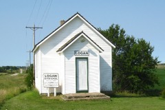 | Logan Center School No.5 | building | 2001 | 00001652 |
| North Grand Avenue Residential Historic District | district | 2014 | 14000212 | |
| Spencer High School and Auditorium | building | 2010 | 10000002 | |
| Wanata State Park Picnic Shelter | building | 1990 | 90001677 |
Every wildfire the federal occurrence database records inside this county: 34 of them, burning about 1,347 acres. 2 started naturally and none was recorded as arson. Each settlement page carries the fires within five miles of it.
| Reported cause | Fires |
|---|---|
| Missing data/not specified/undetermined | 23 |
| Debris and open burning | 5 |
| Smoking | 2 |
| Natural | 2 |
| Misuse of fire by a minor | 1 |
| Equipment and vehicle use | 1 |
The five largest, by the area the report gives. None of them was recorded as arson.
| Date | Cause | Size | Reported by | Name on the report |
|---|---|---|---|---|
| 1 April 2015 | Equipment and vehicle use | 700 acres | Iowa Department of Natural Resources | not named |
| 6 September 2019 | Debris and open burning | 200 acres | Iowa Department of Natural Resources | not named |
| 23 March 2012 | Smoking | 145 acres | Iowa Department of Natural Resources | not named |
| 8 September 2012 | Natural | 100 acres | Iowa Wetland Management District | SMITH SLOUGH WF |
| 11 March 2006 | Missing data/not specified/undetermined | 40 acres | Iowa Department of Natural Resources | not named |
| 8 April 2019 | Debris and open burning | 33 acres | Iowa Department of Natural Resources | not named |
| 9 April 2019 | Debris and open burning | 33 acres | Iowa Department of Natural Resources | not named |
| 14 January 2006 | Missing data/not specified/undetermined | 15 acres | Iowa Department of Natural Resources | not named |
Every settlement page carries the fires within five miles of it - see the settlement index below.
The NOAA Storm Events Database holds 663 reports for this county, causing 1 death, 1 injury and about $35,828,780 in recorded property damage. Each settlement page carries the reports that name it.
| Kind of event | Reports |
|---|---|
| Hail | 250 |
| Thunderstorm Wind | 188 |
| Flood | 165 |
| Tornado | 38 |
| Flash Flood | 18 |
| Heavy Rain | 2 |
| Lightning | 1 |
| Funnel Cloud | 1 |
The most serious of them, by death, then injury, then recorded damage. The accounts are quoted exactly as the forecast office filed them.
| When | Event | Place named | Harm | What the report says |
|---|---|---|---|---|
| June 2024 | Flood | Peterson | 1 killed, $25,590,000 | Rainfall amounts across Clay County from June 20-22 ranged from 3 to 7 inches. Farther north and upstream, up to 10 inches of rain fell across portions of northwest Iowa. This rainfall resulted in extensive overland flooding and record flooding along the Little Sioux and Ocheyedan Rivers. ||The city of Spencer experienced catastrophic flooding when waters from the Little Sioux and Ocheyedan Rivers overtopped the city's berm system. At peak flooding, approximately 383 people were rescued, leaving hundreds of residents displaced. Eighty homes had collapsed or caved-in foundations and roughly 2,100 structures of the 5,100 throughout the city were damaged by flood waters. Numerous others had sewage backup into their basements. ||Many other residences outside of Spencer were also impacted by flood water. County-wide, over 2,400 households were approved for federal disaster assistance, at a cost of over 22 million dollars. Widespread overland flooding also resulted in numerous township, county, and state roads inundated with water and closed. Preliminary damage assessments estimate loss to public infrastructure to be 3.59 million dollars.||One direct fatality occurred on June 22 when a man drowned after attempting to drive across a flooded road with rapidly flowing water. The vehicle was swept off the roadway and moved downstream before coming to rest along a tree line. ||The majority of overland flooding subsided by June 25, but river flooding continued through the end of the month. For additional information on river flooding, please see other entries for Clay County. |
| May 2008 | Thunderstorm Wind | Rossie | 1 hurt, $10,000 | Thunderstorm winds blew down walls of a storage building, causing the building to collapse. Falling rubble injured one man while he was walking to his vehicle after work. |
| July 1995 | Thunderstorm Wind | county wide | $2,500,000 | no account filed |
| March 2019 | Flood | Peterson | $550,000 | Flooding resulted in extensive damage to public infrastructure including numerous county and township roads, culverts, and some bridges. |
| June 2014 | Flood | Fostoria | $500,000 | Persistent heavy rains caused moderate to major flooding of the Little Sioux River. Farmland, other lowlands including parks, and several roads near the river were flooded, including in the city of Spencer. Some homes were flooded, mainly in basements. The river crested at 5.18 feet above flood stage at Spencer on June 20th. |
| September 2005 | Hail | Everly | $500,000 | Large hail fell in an area around 20 miles long and 3 to 5 miles wide. The hail was quarter to golf ball size over most of the area but reached baseball size at Everly. The hail, driven by accompanying damaging winds, broke windows in buildings and vehicles, dented vehicles, and damaged roofs and siding on homes and other buildings. Besides Everly and Webb, the communities of Greenville and Rossie were also affected. The hail covered the ground over much of the area, and was blown into drifts as high as 3 feet. Corn and soybean crops were heavily damaged, with the greater damage to soybean crops. The amount of crop damage was not known. |
| September 2005 | Thunderstorm Wind | Everly | $500,000 | Thunderstorm winds caused widespread tree, power pole, and power line damage along a path around 20 miles long and roughly 5 miles wide. Numerous trees were blown down, some blocking roads, forcing law enforcement to close all roads leading to Everly. Damage to structures was also reported, including shingles blown off roofs, siding damaged, and several small outbuildings and other rural structures destroyed or heavily damaged. Power outages resulted in Everly and in several rural areas. Besides Everly and Webb, the communities of Greenville and Rossie were also affected. The winds also contributed to damage caused by accompanying large hail, and blew the hail into drifts. The amount of crop damage was not known. |
| May 2004 | Hail | Spencer | $500,000 | Large hail caused widespread damage to vehicles, windows, and roofs. Crop damage was also extensive in the area with over one hundred thousand acres of corn, beans, and other small grain crops affected during this storm and another hail storm which occurred later in the day. The amount of crop damage was not known. |
| May 2004 | Hail | Spencer | $500,000 | Large hail damaged vehicles, broke windows, and damaged roofs and siding. Crop damage was also extensive with over one hundred thousand acres of corn, bean, and other small grain crops affected during this storm and another hail storm in the area earlier in the day. The amount of crop damage was not known. Property damage was in addition to the damage from the earlier storm. |
| June 2004 | Tornado (F2) | Everly | $500,000 | A tornado destroyed a hog barn, killing ten hogs, destroyed a greenhouse, destroyed a barn, outbuildings, a machine shed and a garage, and damaged several other farm structures including a horse barn. Several horses were injured. At least two houses were damaged, with windows blown out. Several vehicles were also damaged. Numerous power lines and trees were blown down. The tornado also damaged crops. |
| August 1994 | Thunderstorm Wind | Edgewood | $500,000 | Thunderstorms moved across northeast Iowa throughout the night. In what appeared to be a downburst situation, high winds struck a farm near Edgewood. A narrow path could be seen in the fields surrounding the farm. The farmstead that sustained damage reported one barn blown down by the winds. Sixty head of cattle were within the barn, 12 of them were killed in the collapse. The garage was pulled away from the farm house and toys were strewn across the fields downwind. A chopper box was also overturned. |
| June 1994 | Thunderstorm Wind | Farmersburg | $500,000 | no account filed |
| March 2019 | Flood | Fostoria | $300,000 | Snow melt and heavy rainfall (measured 1.78 inches 4 miles northwest of Milford and 1.59 inches 3 miles south southeast of Lake Park) resulted in significant flooding of agricultural lands and several county roads. Little Sioux River near Milford (gage site MIFI4) reached the second highest stage on record cresting 6.02 feet above flood stage on March 18. |
| June 2008 | Tornado (EF2) | Royal | $300,000 | A tornado destroyed or heavily damaged numerous outbuildings on at least 8 affected farmsteads, with damaged buildings including several large sheds. The tornado damaged numerous grain bins, most of which were carried off their foundations, with some being carried as much as a half mile. The ornado also overturned a camper, blew the top off a silo, destroyed a garage, broke windows on a house, and caused considerable damage to trees, power poles, and power lines. |
| June 2001 | Thunderstorm Wind | Spencer | $300,000 | Thunderstorm winds caused widespread tree damage, with several streets blocked by fallen trees. Some vehicles were damaged by tree debris. The winds tore a wall and part of the roof from a racquet club building. Power lines and poles were blown down, resulting in a one hour power outage which affected almost all of the city of Spencer. |
| July 1986 | Tornado (F1) | not stated | $250,000 | no account filed |
| June 1984 | Tornado (F1) | not stated | $250,000 | no account filed |
| June 1984 | Tornado (F2) | not stated | $250,000 | no account filed |
| May 2004 | Tornado (F1) | Royal | $230,000 | A tornado destroyed a farm house and several other buildings on a farm. |
| August 2005 | Thunderstorm Wind | Greenville | $150,000 | Thunderstorm winds caused widespread tree and power line damage, with many trees blown down. Power lines and poles were blown down along a stretch of several miles. One large tree severely damaged a pickup and trailer when it was blown down. The winds also destroyed small farm buildings and damaged equipment. The winds and accompanying small hail damaged crops, but the amount of crop damage was not known. |
| August 2005 | Thunderstorm Wind | Peterson | $100,000 | Thunderstorm winds severely damaged a small house and caused widespread tree damage. |
| August 2005 | Thunderstorm Wind | Gillett Grove | $100,000 | Thunderstorm winds destroyed a 30 foot by 70 foot hog house, and destroyed smaller farm buildings. The winds damaged the roof, siding, and windows of the house on the farm. The winds also caused tree and power line damage and flattened corn crops. The amount of crop damage was not known. |
| June 2014 | Flood | Everly | $50,000 | Persistent moderate to heavy rain caused flooding of fields and other lowlands, including several roads, homes, and businesses. This flooding lasted for almost two days, and was aggravated locally by additional storms during that time. Some roads were damaged or washed out. |
| May 2013 | Flood | Everly | $50,000 | Heavy rain caused minor to moderate flooding of the Ocheyedan River near Spencer. Lowlands including a few roads were affected. The river crested at 2.0 feet above flood stage near Spencer on May 28th. |
| July 2010 | Thunderstorm Wind | Fostoria | $50,000 | Thunderstorm winds caused widespread tree and power line damage. Shingles were blown off roofs, and several roofs and vehicles were damaged by tree debris. |
| June 2004 | Tornado (F3) | Webb | $50,000 | A large cone shaped tornado tore a steel bridge from a road. The tornado raised a large debris cloud as it moved over open country, causing damage to crops and power lines. The tornado moved into Clay County after forming just south of the County Line. |
| August 2002 | Thunderstorm Wind | Royal | $50,000 | Thunderstorm winds cause tree damage, and blew down power lines, starting a small fire. One tree fell on and severely damaged a camper. |
| October 2002 | Hail | Royal | $50,000 | Large hail fell in an area 5 to 10 miles wide from west to east across the central part of the county. The hail caused widespread severe damage to corn and soybean crops with many crops totally destroyed. The hail also damaged vehicles and broke some windows where the largest hail fell near Royal. |
| June 1994 | Thunderstorm Wind | Elkader | $50,000 | no account filed |
| July 1994 | Thunderstorm Wind | Strawberry Point | $50,000 | no account filed |
| June 1994 | Hail | Langdon | $50,000 | no account filed |
| June 1994 | Hail | Langdon | $50,000 | no account filed |
| August 1993 | Thunderstorm Wind | Spencer | $50,000 | no account filed |
| December 2021 | Thunderstorm Wind | Royal | $25,000 | Thunderstorm winds knocked down an old barn, with several other outbuildings damaged. Property damage costs are a rough estimate. |
| September 1986 | Tornado (F1) | not stated | $25,000 | no account filed |
| September 1980 | Tornado (F3) | not stated | $25,000 | no account filed |
| May 1959 | Tornado (F1) | not stated | $25,000 | no account filed |
| August 1954 | Tornado (F1) | not stated | $25,000 | no account filed |
| July 2010 | Thunderstorm Wind | Spencer | $20,000 | Thunderstorm winds caused tree damage, including a large tree that fell on and damaged a house. |
| June 2001 | Thunderstorm Wind | Langdon | $20,000 | Thunderstorm winds caused tree damage, and blew the roof off a building. |
| May 1998 | Thunderstorm Wind | Everly | $20,000 | no account filed |
| July 1995 | Hail | not stated | $20,000 | no account filed |
| August 1995 | Thunderstorm Wind | Marquette | $20,000 | no account filed |
| July 2010 | Thunderstorm Wind | Maclay | $15,000 | Thunderstorm winds destroyed a barn, and spread the debris across several fields. |
| May 2012 | Thunderstorm Wind | Spencer | $10,000 | Thunderstorm winds caused tree damage, including numerous trees blown down. The winds also blew out windows. |
| September 2001 | Lightning | Peterson | $10,000 | Lightning struck a radio antenna on a house. A radio and converter box were destroyed. Several other pieces of electrical equipment on or in the house were damaged including a television satellite dish and converter boxes, computer, garage door opener, water softener, central vac system, and sky lights. Lightning also struck a tree next to another house, splitting open the tree from top to bottom. |
| October 2019 | Flood | Fostoria | $5,000 | Rainfall from October 1-5 totaled 4.81 inches at Lake Park, 4.61 inches at Spirit Lake, 3.85 inches 3 miles south-southeast of Lake Park and 3.34 inches 4 miles northwest of Milford. The Little Sioux River near Milford (gage site MIFI4) climbed into minor flood and crested 1.24 feet above flood stage on October 6. Flooding impacts were generally to agricultural areas near the river, however, water did briefly inundate 190th Avenue near 240th Street. Property and crop damage costs are rough estimates. |
| October 2019 | Flood | Spencer | $5,000 | Rainfall from October 1-5 totaled 4.81 inches at Lake Park, 4.61 inches at Spirit Lake, 3.85 inches 3 miles south-southeast of Lake Park and 3.65 inches at Spencer. The Little Sioux River at Spencer (gage site SPWI4) climbed into minor flood and crested 1.65 feet above flood stage on October 7. Flooding impacts were generally to agricultural areas, with water inundating the City Park in Spencer. Property and crop damage costs are rough estimates. |
| June 2014 | Tornado (EF0) | Royal | $5,000 | A brief tornado damaged a few outbuildings. |
| May 2012 | Tornado (EF0) | Moneta | $5,000 | A tornado damaged several power poles. |
| May 2012 | Thunderstorm Wind | Dickens | $5,000 | Thunderstorm winds caused tree damage, and also damaged a roof. |
| June 2011 | Thunderstorm Wind | Rossie | $5,000 | Thunderstorm winds blew down trees and power lines. |
| June 2011 | Thunderstorm Wind | Greenville | $5,000 | Thunderstorm winds blew down trees and power lines. |
| June 1999 | Thunderstorm Wind | Spencer | $5,000 | Thunderstorm winds blew down signs and caused tree damage. |
| July 1996 | Thunderstorm Wind | Greenville | $5,000 | no account filed |
| July 1995 | Thunderstorm Wind | Garnavillo | $5,000 | no account filed |
| April 1994 | Hail | Strawberry Point | $5,000 | no account filed |
| June 1994 | Thunderstorm Wind | Elkader | $5,000 | no account filed |
| June 1994 | Thunderstorm Wind | Edgewood | $5,000 | no account filed |
| July 1994 | Thunderstorm Wind | Clayton | $5,000 | no account filed |
The Survey's mineral resources record lists 66 workings inside this county. 6 still produce and 60 are closed or unrecorded. Each settlement page carries the workings within five miles of it.
| Commodity | Workings |
|---|---|
| Sand and Gravel, Construction | 66 |
The least common of them first, because a county's hundredth gravel pit says nothing its first ten did not.
| Where | Site | Commodity | Status | Recorded |
|---|---|---|---|---|
| Carlson Brothers Gravel | Sand and Gravel, Construction | Producer | ||
| Clay County Pits | Sand and Gravel, Construction | Producer | ||
| Collins Pit | Sand and Gravel, Construction | Past Producer | ||
| Cornell Pit | Sand and Gravel, Construction | Past Producer | ||
| Eckley Pit | Sand and Gravel, Construction | Past Producer | ||
| Johnson Pit | Sand and Gravel, Construction | Past Producer | ||
| Kuehl Pit | Sand and Gravel, Construction | Past Producer | ||
| Niemand Pit | Sand and Gravel, Construction | Past Producer | ||
| Norgaard Gravel | Sand and Gravel, Construction | Producer | ||
| Norgaard Pit | Sand and Gravel, Construction | Past Producer | ||
| Otto Pit | Sand and Gravel, Construction | Past Producer | ||
| Ralphs Sand and Gravel | Sand and Gravel, Construction | Producer | ||
| Ruthven Pit | Sand and Gravel, Construction | Past Producer | ||
| Scharnburg Pit | Sand and Gravel, Construction | Past Producer | ||
| Spencer Pit | Sand and Gravel, Construction | Producer | ||
| Spencer Pit | Sand and Gravel, Construction | Producer | ||
| Stellish Pit | Sand and Gravel, Construction | Past Producer | ||
| Stolley Pit | Sand and Gravel, Construction | Past Producer | ||
| Straub Pit | Sand and Gravel, Construction | Past Producer | ||
| Unknown | Sand and Gravel, Construction | Past Producer | ||
| Unknown | Sand and Gravel, Construction | Past Producer | ||
| Unknown | Sand and Gravel, Construction | Past Producer | ||
| Unknown | Sand and Gravel, Construction | Past Producer | ||
| Unknown | Sand and Gravel, Construction | Past Producer | ||
| Unknown | Sand and Gravel, Construction | Past Producer | ||
| Unknown | Sand and Gravel, Construction | Past Producer | ||
| Unknown | Sand and Gravel, Construction | Past Producer | ||
| Unknown | Sand and Gravel, Construction | Past Producer | ||
| Unknown | Sand and Gravel, Construction | Past Producer | ||
| Unknown | Sand and Gravel, Construction | Past Producer | ||
| Unknown | Sand and Gravel, Construction | Past Producer | ||
| Unknown | Sand and Gravel, Construction | Past Producer | ||
| Unknown | Sand and Gravel, Construction | Past Producer | ||
| Unknown | Sand and Gravel, Construction | Past Producer | ||
| Unknown | Sand and Gravel, Construction | Past Producer | ||
| Unknown | Sand and Gravel, Construction | Past Producer | ||
| Unknown | Sand and Gravel, Construction | Past Producer | ||
| Unknown | Sand and Gravel, Construction | Past Producer | ||
| Unknown | Sand and Gravel, Construction | Past Producer | ||
| Unknown | Sand and Gravel, Construction | Past Producer | ||
| Unknown | Sand and Gravel, Construction | Past Producer | ||
| Unknown | Sand and Gravel, Construction | Past Producer | ||
| Unknown | Sand and Gravel, Construction | Past Producer | ||
| Unknown | Sand and Gravel, Construction | Past Producer | ||
| Unknown | Sand and Gravel, Construction | Past Producer | ||
| Unknown | Sand and Gravel, Construction | Past Producer | ||
| Unknown | Sand and Gravel, Construction | Past Producer | ||
| Unknown | Sand and Gravel, Construction | Past Producer | ||
| Unknown | Sand and Gravel, Construction | Past Producer | ||
| Unknown | Sand and Gravel, Construction | Past Producer | ||
| Unknown | Sand and Gravel, Construction | Past Producer | ||
| Unknown | Sand and Gravel, Construction | Past Producer | ||
| Unknown | Sand and Gravel, Construction | Past Producer | ||
| Unknown | Sand and Gravel, Construction | Past Producer | ||
| Unknown | Sand and Gravel, Construction | Past Producer | ||
| Unknown | Sand and Gravel, Construction | Past Producer | ||
| Unknown | Sand and Gravel, Construction | Past Producer | ||
| Unknown | Sand and Gravel, Construction | Past Producer | ||
| Unknown | Sand and Gravel, Construction | Past Producer | ||
| Unknown | Sand and Gravel, Construction | Past Producer | ||
| Unknown | Sand and Gravel, Construction | Past Producer | ||
| Unknown | Sand and Gravel, Construction | Past Producer | ||
| Unknown | Sand and Gravel, Construction | Past Producer | ||
| Unknown | Sand and Gravel, Construction | Past Producer | ||
| Unknown | Sand and Gravel, Construction | Past Producer | ||
| Unknown | Sand and Gravel, Construction | Past Producer |
Named settlements recorded in the Geographic Names Information System, each with the topographic sheets covering it. Villages, hamlets and abandoned places alike. Each is shown with the nearest named watercourse or landform and the survey quadrangle it falls on.
Gillett Grove township · 51341 · On Elk Creek · Gillett Grove quadrangle
7 sheets, 1954 to 1985
The vanished settlements of Clay County: the places named above that are no longer on the map.