 Block
From the record
12 National Register listings published here, 1 of them a National Historic Landmark.
Sources: the National Register database, National Park Service
23 topographic sheets cover 26 settlements here, and 12 properties are on the National Register of Historic Places.
12 National Register listings published here, 1 of them a National Historic Landmark.
Sources: the National Register database, National Park Service
Every property in this county listed on the National Register of Historic Places, with the year it was listed and the federal nomination document.
| Photograph | Property | Type | Listed | Reference |
|---|---|---|---|---|
| "Lockkeeper's" House | building | 2009 | 09000826 | |
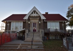 | Bloomfield Public Library | building | 2015 | 15000721 |
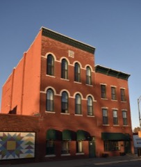 | Bloomfield Square | district | 1976 | 76000756 |
 | Davis County Courthouse | building | 1974 | 74000779 |
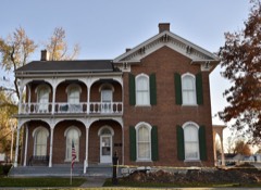 | William Findley House | building | 1978 | 78001213 |
| Stringtown House | building | 1974 | 74000780 | |
| Trimble-Parker Historic Farmstead District | building | 2003 | 03000125 | |
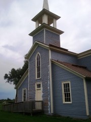 | Troy Academy | building | 1976 | 76000758 |
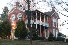 | James B. Weaver House | building | 1975 | 75000680 |
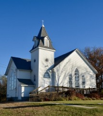 | West Grove United Methodist Church | building | 2004 | 04000514 |
 | Asa Wilson House | building | 1982 | 82000404 |
 | Henry Wishard House | building | 2004 | 04001350 |
Every wildfire the federal occurrence database records inside this county: 94 of them, burning about 5,477 acres. None started naturally and 1 was recorded as arson. Each settlement page carries the fires within five miles of it.
| Reported cause | Fires |
|---|---|
| Debris and open burning | 61 |
| Missing data/not specified/undetermined | 24 |
| Smoking | 4 |
| Equipment and vehicle use | 4 |
| Arson/incendiarism | 1 |
The five largest, by the area the report gives. None of them was recorded as arson.
| Date | Cause | Size | Reported by | Name on the report |
|---|---|---|---|---|
| 4 March 2017 | Debris and open burning | 640 acres | Iowa Department of Natural Resources | not named |
| 11 April 2020 | Debris and open burning | 500 acres | Iowa Department of Natural Resources | not named |
| 30 March 2020 | Debris and open burning | 454 acres | Iowa Department of Natural Resources | not named |
| 21 February 2017 | Missing data/not specified/undetermined | 340 acres | Iowa Department of Natural Resources | not named |
| 14 February 2017 | Missing data/not specified/undetermined | 160 acres | Iowa Department of Natural Resources | not named |
| 18 March 2017 | Debris and open burning | 125 acres | Iowa Department of Natural Resources | not named |
| 8 March 2020 | Debris and open burning | 123 acres | Iowa Department of Natural Resources | not named |
| 19 February 2017 | Debris and open burning | 120 acres | Iowa Department of Natural Resources | not named |
Every settlement page carries the fires within five miles of it - see the settlement index below.
The NOAA Storm Events Database holds 276 reports for this county, causing no deaths, no injuries and about $34,532,500 in recorded property damage. Each settlement page carries the reports that name it.
| Kind of event | Reports |
|---|---|
| Thunderstorm Wind | 90 |
| Hail | 87 |
| Heavy Rain | 51 |
| Tornado | 20 |
| Flash Flood | 18 |
| Flood | 5 |
| Funnel Cloud | 3 |
| Lightning | 2 |
The most serious of them, by death, then injury, then recorded damage. The accounts are quoted exactly as the forecast office filed them.
| When | Event | Place named | Harm | What the report says |
|---|---|---|---|---|
| May 1988 | Tornado (F2) | not stated | $25,000,000 | no account filed |
| June 1980 | Tornado (F2) | not stated | $2,500,000 | no account filed |
| June 2009 | Thunderstorm Wind | Bloomfield | $1,000,000 | KMEM Radio reported that the Davis County Courthouse and several businesses had shattered windows and a local high school had a partial roof collapse. Damage was caused by combination of wind and hail. |
| April 1999 | Tornado (F3) | Bloomfield | $550,000 | no account filed |
| August 2007 | Flash Flood | Pulaski | $500,000 | Four feet of water was reported with a car stranded on the road. Water was backing up into basements. Gravel roads countywide reportedly had washouts with many shoulder washouts. |
| May 2019 | Flood | Ash Grove | $300,000 | Emergency manager reported multiple secondary secondary roads remained under water or closed, a few culverts known to be damaged or destroyed, and one rural wood truss bridge lost in Davis County from the rainfall and subsequent overland and river flooding yesterday. The Fox River rose over 15 feet in 5 hours at Bloomfield. A rural truss wooden bridge was damaged. |
| June 2011 | Flash Flood | Bloomfield Arpt | $250,000 | Water nearly to the tops of cars in streets of Bloomfield. Manhole covers were blown off. |
| April 2007 | Flood | Floris | $250,000 | no account filed |
| March 1990 | Tornado (F1) | not stated | $250,000 | no account filed |
| April 1989 | Tornado (F2) | not stated | $250,000 | no account filed |
| May 1988 | Tornado (F2) | not stated | $250,000 | no account filed |
| September 1965 | Tornado (F2) | not stated | $250,000 | no account filed |
| August 2007 | Flash Flood | Floris | $200,000 | City streets were flooded up to 1 foot deep and barricaded. A storage shed floated off of its foundation. One backyard was flooded to top of fence, caused by ponding and poor drainage. |
| March 2006 | Thunderstorm Wind | Bloomfield | $150,000 | no account filed |
| June 2000 | Flash Flood | Bloomfield | $150,000 | no account filed |
| November 2024 | Tornado (EF0) | Belknap | $120,000 | A brief tornado occurred south of Floris from a developing weak storm. The tornado moved across a farmstead on the west side of Pecan Avenue producing high end EF0 damage to two metal buildings. The tornado lifted shortly afterwards. |
| May 2019 | Flash Flood | Ash Grove | $100,000 | Emergency manager reported that several secondary roads in Monroe and Davis Counties have water over them and will be barricaded and closed. Debris in streams also a concern for damaging culverts. |
| June 2015 | Thunderstorm Wind | Bloomfield | $100,000 | Public report of trees and power lines down and traffic light bent within the city of Bloomfield. Also observed pea to quarter sized hail. |
| July 2015 | Thunderstorm Wind | Drakesville | $100,000 | Winds of 65 to 70 mph were estimated across western Davis County with several large limbs down around the county. |
| May 2013 | Thunderstorm Wind | Pulaski | $100,000 | Numerous large trees and power lines down in town. Many roofs damaged by falling trees. |
| July 2008 | Thunderstorm Wind | Pulaski | $100,000 | no account filed |
| August 2004 | Flash Flood | Countywide | $100,000 | no account filed |
| June 2000 | Flash Flood | Countywide | $100,000 | no account filed |
| May 2013 | Thunderstorm Wind | Floris | $75,000 | Tin blown off barns and sheds blown down. |
| July 2008 | Flash Flood | Bloomfield | $75,000 | One to three feet of water covered the streets. |
| April 1997 | Thunderstorm Wind | Bloomfield | $75,000 | no account filed |
| May 1996 | Tornado (F1) | Pulaski | $75,000 | no account filed |
| June 2014 | Flash Flood | Mark | $50,000 | Law enforcement reported a vehicle submerged by flood waters at 274th Street and Balsa Ave. |
| September 2008 | Flash Flood | Pulaski | $50,000 | The North Wyaconda Creek was out of its banks and one quarter of a mile wide in spots. Water was over gravel roads. |
| September 2008 | Flood | Pulaski | $50,000 | no account filed |
| August 2006 | Lightning | Drakesville | $50,000 | no account filed |
| August 2001 | Flash Flood | Northeast Portion | $50,000 | no account filed |
| May 1998 | Flood | Bloomfield | $50,000 | no account filed |
| March 1998 | Thunderstorm Wind | Troy | $50,000 | no account filed |
| June 1994 | Hail | Paris | $50,000 | no account filed |
| June 1994 | Hail | Floris | $50,000 | no account filed |
| June 2000 | Thunderstorm Wind | Floris | $35,000 | no account filed |
| June 1998 | Thunderstorm Wind | Mark | $35,000 | no account filed |
| July 1997 | Thunderstorm Wind | Bloomfield | $30,000 | no account filed |
| June 2015 | Thunderstorm Wind | West Grove | $25,000 | Trained spotter reported numerous tree branches down in the West Grove community. Also reported metal roof damage to a local business. Time estimated by radar. |
| June 2015 | Flash Flood | Steuben | $25,000 | Law enforcement reported water over road a few feet deep near the intersection of Jefferson St and West St in Bloomfield. The water was deep enough to have to tow a couple of vehicles out of the water. There were also a few county roads underwater in southern Davis county. |
| July 2015 | Thunderstorm Wind | Drakesville | $25,000 | Public reported several power lines down due to strong winds about 1 mile north of Drakesvile. |
| June 2014 | Flash Flood | West Grove | $25,000 | Six to eight inches of water covered about 300 yards of Highway 2 about 1.5 miles west of West Grove. |
| June 2014 | Flash Flood | West Grove | $25,000 | Water was reported over the road and a bridge had water over it on 245th between Dewberry and Ebony. |
| September 2014 | Flash Flood | Ash Grove | $25,000 | Flash flooding was reported in several areas across the county throughout the night with numerous roads affected. |
| June 2011 | Thunderstorm Wind | Paris | $25,000 | Large trees were uprooted in the town of West Grove. |
| June 2011 | Thunderstorm Wind | Pulaski | $25,000 | Large trees were down in Pulaski from thunderstorm winds. |
| August 2010 | Flash Flood | Carbon | $25,000 | Bridge impassable due to flash flooding. |
| August 2010 | Thunderstorm Wind | Pulaski | $25,000 | A storage facility was damaged by thunderstorms winds. |
| April 2008 | Tornado (EF0) | Belknap | $25,000 | Public reports indicated a tornado with an intermittent track. Trees were downed and a roof was blown off. A garage was possibly down 1 mile west of the Floris turnoff of Highway 63, to the turnoff of Highway 63. |
| July 2008 | Flash Flood | Steuben | $25,000 | Water from the Fox River covered parts of County road J40. |
| July 2008 | Thunderstorm Wind | Bloomfield | $25,000 | A few large trees, between 12 and 18 inches in diameter, were blown down along with several large tree limbs of 6 to 10 inch diameter, throughout the town of Bloomfield. |
| June 2009 | Hail | Bloomfield | $25,000 | no account filed |
| July 2006 | Hail | Bloomfield | $25,000 | no account filed |
| July 2004 | Thunderstorm Wind | Bloomfield | $25,000 | no account filed |
| September 2001 | Hail | Bloomfield | $25,000 | no account filed |
| April 1987 | Tornado (F1) | not stated | $25,000 | no account filed |
| June 1979 | Tornado (F0) | not stated | $25,000 | no account filed |
| May 1977 | Tornado (F1) | not stated | $25,000 | no account filed |
| January 1967 | Tornado (F4) | not stated | $25,000 | no account filed |
The Survey's mineral resources record lists 8 workings inside this county. 1 still produces and 7 are closed or unrecorded. Each settlement page carries the workings within five miles of it.
| Commodity | Workings |
|---|---|
| Zinc | 3 |
| Stone, Crushed/Broken | 3 |
| Sand and Gravel, Construction | 1 |
| Flagstone | 1 |
The least common of them first, because a county's hundredth gravel pit says nothing its first ten did not.
| Where | Site | Commodity | Status | Recorded |
|---|---|---|---|---|
| Unknown | Sand and Gravel, Construction | Past Producer | ||
| Welch Sandstone Quarry | Flagstone | Past Producer | ||
| Drill Hole | Zinc | Past Producer | Sphalerite | |
| Drill Hole | Zinc | Past Producer | Sphalerite | |
| Hootman Farm Quarry | Stone, Crushed/Broken | Past Producer | ||
| Lewis Quarry | Stone, Crushed/Broken | Producer | ||
| Nupp Quarry | Stone, Crushed/Broken | Past Producer | ||
| Orill Hole | Zinc | Past Producer | Sphalerite |
Named settlements recorded in the Geographic Names Information System, each with the topographic sheets covering it. Villages, hamlets and abandoned places alike. Each is shown with the nearest named watercourse or landform and the survey quadrangle it falls on.
Marion township · 52552 · On South Soap Creek · Paris quadrangle
7 sheets, 1954 to 1981
No longer a settlement
Salt Creek township · 52560 · Selma quadrangle
7 sheets, 1954 to 1981
No longer a settlement
Union township · 52537 · On Hickory Creek · Milton quadrangle
7 sheets, 1954 to 1981
No longer a settlement
Lick Creek township · 52537 · Bloomfield North quadrangle
10 sheets, 1954 to 1981
No longer a settlement
Wyacondah township · 52537 · On Batten Branch · Bunker Hill quadrangle
7 sheets, 1954 to 1981
Lick Creek township · 52537 · Bloomfield North quadrangle
10 sheets, 1954 to 1981
No longer a settlement
Fabius township · 52537 · West Grove quadrangle
7 sheets, 1954 to 1981
No longer a settlement
The vanished settlements of Davis County: the places named above that are no longer on the map.