 Block
From the record
3 National Register listings published here.
Sources: the National Register database, National Park Service
14 topographic sheets cover 14 settlements here, and 3 properties are on the National Register of Historic Places.
3 National Register listings published here.
Sources: the National Register database, National Park Service
Every property in this county listed on the National Register of Historic Places, with the year it was listed and the federal nomination document.
| Photograph | Property | Type | Listed | Reference |
|---|---|---|---|---|
| Brugjeld-Peterson Family Farmstead District | district | 2000 | 00000326 | |
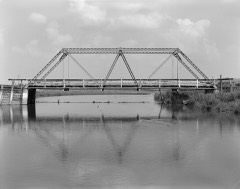 | Ellsworth Ranch Bridge | structure | 1998 | 98000869 |
| Thomsen Round Barn | building | 1986 | 86001426 |
Every wildfire the federal occurrence database records inside this county: 33 of them, burning about 504 acres. 1 started naturally and none was recorded as arson. Each settlement page carries the fires within five miles of it.
| Reported cause | Fires |
|---|---|
| Missing data/not specified/undetermined | 25 |
| Equipment and vehicle use | 4 |
| Debris and open burning | 3 |
| Natural | 1 |
The five largest, by the area the report gives. None of them was recorded as arson.
| Date | Cause | Size | Reported by | Name on the report |
|---|---|---|---|---|
| 30 March 2020 | Debris and open burning | 200 acres | Iowa Department of Natural Resources | not named |
| 29 September 2011 | Missing data/not specified/undetermined | 70 acres | Iowa Department of Natural Resources | 260TH ST/270TH ST. TWELVE MILE LAKE TOWNSHIP, IA |
| 30 March 2015 | Debris and open burning | 60 acres | Iowa Department of Natural Resources | not named |
| 6 May 2004 | Natural | 59 acres | Iowa Wetland Management District | HERMSEN |
| 9 April 2007 | Missing data/not specified/undetermined | 30 acres | Iowa Department of Natural Resources | not named |
| 29 September 2011 | Missing data/not specified/undetermined | 22 acres | Iowa Department of Natural Resources | 430TH AVE BY 260TH ST., HIGH LAKE, IA |
| 18 May 2011 | Missing data/not specified/undetermined | 15 acres | Iowa Department of Natural Resources | 2289 480TH AVE. , IA |
| 6 April 2006 | Missing data/not specified/undetermined | 10 acres | Iowa Department of Natural Resources | not named |
Every settlement page carries the fires within five miles of it - see the settlement index below.
The NOAA Storm Events Database holds 374 reports for this county, causing no deaths, no injuries and about $19,176,030 in recorded property damage. Each settlement page carries the reports that name it.
| Kind of event | Reports |
|---|---|
| Thunderstorm Wind | 128 |
| Hail | 122 |
| Flood | 47 |
| Heavy Rain | 36 |
| Tornado | 21 |
| Flash Flood | 13 |
| Lightning | 4 |
| Funnel Cloud | 3 |
The most serious of them, by death, then injury, then recorded damage. The accounts are quoted exactly as the forecast office filed them.
| When | Event | Place named | Harm | What the report says |
|---|---|---|---|---|
| June 2024 | Flood | Wellingford | $10,000,000 | The West Fork of the Des Moines at Estherville crested at 18.1 ft on June 24 at 09:00 am CDT. The river remained in flood through the end of the month and into July. Preliminary information indicates this is the new flood of record for the point. |
| April 1967 | Tornado (F2) | not stated | $2,500,000 | no account filed |
| June 2014 | Flash Flood | Wallingford | $500,000 | Highway 4 was closed with flooding in Wallingford serious enough that evacuations were taking place. Railroad tracks also sustained damage in town. |
| June 2010 | Flash Flood | Wellingford | $500,000 | Extensive flooding along 1st, 2nd, and 3rd streets in town. Foundation caved in with up to 4 feet of water in basements. |
| June 2011 | Flood | Huntington | $250,000 | no account filed |
| June 2010 | Flood | Huntington | $250,000 | no account filed |
| April 1967 | Tornado (F2) | not stated | $250,000 | no account filed |
| March 1953 | Tornado (F3) | not stated | $250,000 | no account filed |
| May 2019 | Flood | Wellingford | $200,000 | The West Fork of the Des River crested 6 times through the month of May. The crests are as follows: first, 10.5 ft on 9 May 2019 at 21:30 UTC, second, 10.07 ft on 15 May 2019 at 12:30 UTC, third, 8.88 ft on 23 May 2019 at 01:15 UTC, fourth, 9.28 ft on 25 May 2019 at 07:45 UTC, fifth, 12.3 ft on 28 May 2019 at 12:00 UTC, and sixth at 13.32 ft on 30 May 2019 at 16:45 UTC. |
| April 2018 | Flood | Wellingford | $200,000 | The West Fork of the Des Moines River crested at 12.01 feet on 30 April 2018 at 01:30 UTC. |
| April 2018 | Flood | Wellingford | $200,000 | The West Fork of the Des Moines River at Estherville crested at 8.96 feet on 4 April 2018 at 1:00 UTC. |
| September 2004 | Flash Flood | Countywide | $200,000 | no account filed |
| July 1998 | Thunderstorm Wind | Estherville | $200,000 | no account filed |
| June 2010 | Flash Flood | Wellingford | $150,000 | Residents being evacuated in town due to creek flooding. Highway 4 also closed due to flooding. |
| March 2018 | Flood | Wellingford | $100,000 | The West Fork of the Des Moines River at Estherville crested at 10.22 feet on 29 March 2018 at 1800 UTC. |
| April 2018 | Flood | Nemaha | $100,000 | The West Fork of the Des Moines River at Emmetsburg crested at 11.39 feet on 27 April 2018 at 3:00 UTC. |
| April 2018 | Flood | Nemaha | $100,000 | The West Fork of the Des Moines River at Emmetsburg crested at 11.17 feet on 30 April 2018 at 11:00 UTC. |
| June 2018 | Flood | Wellingford | $100,000 | The West Fork of the Des Moines River at Estherville crested twice through the period of flooding. The river remained in flood into July. The first crest was at 12.67 feet on 22 June 2018 at 08:30 UTC, and the second one was at 13.33 feet on 25 June 2018 at 21:00 UTC. |
| July 2018 | Flood | Wellingford | $100,000 | The West Fork of the Des Moines River at Estherville went into flood in late June and remained in flood through nearly all of July. The river crested 4 times in July. The first crest at 14.63 feet on 2 July 2018 at 05:15Z, the second crest at 14.89 feet on 9 July 2018 at 19:15 UTC, the third crest at 13.39 feet on 13 July 2018 at 07:15 UTC, and the fourth crest at 13.25 feet on 13 July 2018 at 18:30 UTC. |
| September 2018 | Flood | Wellingford | $100,000 | The West Fork of the Des Moines River at Estherville crested twice through the period and remained in flood into October. The first crest was at 10.62 feet on 21 September 2018 at 2145 UTC, the second crest was at 9.81 feet on 29 September 2018 at 1915 UTC. |
| July 2011 | Flash Flood | Wallingford | $100,000 | Several secondary roads flash flooded in Wallingford. Three to four inches of rain fell between Wallingford and Graettinger. |
| June 2011 | Thunderstorm Wind | Armstrong | $100,000 | A 66 foot by 76 foot barn, 50 feet high, was destroyed by high winds. A grain bin was blown off its concrete pad. Debris, grass, and corn was blown across the highway. |
| March 2011 | Flood | Huntington | $100,000 | no account filed |
| May 2011 | Flood | Huntington | $100,000 | no account filed |
| March 2010 | Flood | Huntington | $100,000 | no account filed |
| September 2010 | Flood | Huntington | $100,000 | no account filed |
| July 1998 | Thunderstorm Wind | Estherville | $100,000 | no account filed |
| October 2017 | Flood | Wellingford | $80,000 | The West Fork of the Des Moines River at Estherville crested at 9.85 feet on 12 October 2017 at 06:45 UTC. |
| July 2007 | Thunderstorm Wind | Armstrong | $75,000 | no account filed |
| May 2018 | Flood | Wellingford | $50,000 | The West Fork of the Des Moines River at Estherville crested at 8.42 feet on 25 May 2018 at 17:15 UTC. |
| June 2010 | Thunderstorm Wind | Wallingford | $50,000 | Grain bin down and blown into ditch. |
| June 2011 | Flood | Huntington | $50,000 | no account filed |
| April 2010 | Flood | Huntington | $50,000 | no account filed |
| July 2010 | Flood | Huntington | $50,000 | no account filed |
| June 2008 | Flood | Huntington | $50,000 | no account filed |
| July 2007 | Thunderstorm Wind | Estherville | $50,000 | no account filed |
| March 2007 | Flood | Estherville | $50,000 | no account filed |
| June 2001 | Flash Flood | Countywide | $50,000 | no account filed |
| July 2000 | Flash Flood | Countywide | $50,000 | no account filed |
| July 1998 | Thunderstorm Wind | Wallingford | $50,000 | no account filed |
| July 1997 | Thunderstorm Wind | Ringsted | $50,000 | no account filed |
| May 1994 | Hail | Armstrong | $50,000 | no account filed |
| May 1997 | Lightning | Estherville | $40,000 | no account filed |
| September 2018 | Thunderstorm Wind | Estherville | $30,000 | Public reported a dugout at a local baseball field was destroyed and that the bowling alley experienced partial roof destruction. This is a delayed report. |
| May 2000 | Thunderstorm Wind | Estherville | $30,000 | no account filed |
| May 2016 | Flood | Peoria | $25,000 | The Des Moines River at Estherville crested at 11:00 pm CDT on 1 May 2016 at 9.05 feet. |
| June 2015 | Thunderstorm Wind | Raleigh | $25,000 | Emergency Manager reported trees down in Estherville and SW of town. |
| May 2015 | Hail | Raleigh | $25,000 | Sixty MPH wind gusts occurred with the hail. |
| August 2010 | Thunderstorm Wind | Wellingford | $25,000 | Fire chief reported a roof blown off in Wallingford. |
| October 2010 | Flood | Huntington | $25,000 | no account filed |
| March 2007 | Flash Flood | Estherville | $25,000 | no account filed |
| July 2007 | Thunderstorm Wind | Estherville | $25,000 | no account filed |
| July 2007 | Thunderstorm Wind | Estherville | $25,000 | no account filed |
| May 2007 | Flood | Estherville | $25,000 | no account filed |
| July 2007 | Thunderstorm Wind | Armstrong | $25,000 | no account filed |
| August 2006 | Flash Flood | Estherville | $25,000 | no account filed |
| May 2005 | Flash Flood | Estherville | $25,000 | no account filed |
| May 2005 | Hail | Ringsted | $25,000 | no account filed |
| August 2002 | Lightning | Ringsted | $25,000 | no account filed |
| June 2001 | Thunderstorm Wind | Dolliver | $25,000 | no account filed |
The Survey's mineral resources record lists 41 workings inside this county. 8 still produce and 33 are closed or unrecorded. Each settlement page carries the workings within five miles of it.
| Commodity | Workings |
|---|---|
| Sand and Gravel, Construction | 41 |
The least common of them first, because a county's hundredth gravel pit says nothing its first ten did not.
| Where | Site | Commodity | Status | Recorded |
|---|---|---|---|---|
| City Pit | Sand and Gravel, Construction | Past Producer | ||
| Clark Pit | Sand and Gravel, Construction | Past Producer | ||
| Dolliver Pit | Sand and Gravel, Construction | Unknown | ||
| Egeland | Sand and Gravel, Construction | Producer | ||
| Egeland Pit | Sand and Gravel, Construction | Past Producer | ||
| Emmet County Pits | Sand and Gravel, Construction | Producer | ||
| Estherville City Pit | Sand and Gravel, Construction | Past Producer | ||
| Estherville Pit | Sand and Gravel, Construction | Producer | ||
| Estherville S and G | Sand and Gravel, Construction | Past Producer | ||
| Farmer Pit | Sand and Gravel, Construction | Past Producer | ||
| Frye Pit | Sand and Gravel, Construction | Producer | ||
| Gaarde Pit | Sand and Gravel, Construction | Past Producer | ||
| Johnson Pit | Sand and Gravel, Construction | Past Producer | ||
| Kossuth County Pit | Sand and Gravel, Construction | Producer | ||
| Lucas Pit | Sand and Gravel, Construction | Past Producer | ||
| Mauer Pit | Sand and Gravel, Construction | Past Producer | ||
| North Pit and Plant | Sand and Gravel, Construction | Producer | ||
| Twite Pit | Sand and Gravel, Construction | Past Producer | ||
| Unknown | Sand and Gravel, Construction | Past Producer | ||
| Unknown | Sand and Gravel, Construction | Past Producer | ||
| Unknown | Sand and Gravel, Construction | Past Producer | ||
| Unknown | Sand and Gravel, Construction | Past Producer | ||
| Unknown | Sand and Gravel, Construction | Past Producer | ||
| Unknown | Sand and Gravel, Construction | Producer | ||
| Unknown | Sand and Gravel, Construction | Past Producer | ||
| Unknown | Sand and Gravel, Construction | Past Producer | ||
| Unknown | Sand and Gravel, Construction | Past Producer | ||
| Unknown | Sand and Gravel, Construction | Past Producer | ||
| Unknown | Sand and Gravel, Construction | Past Producer | ||
| Unknown | Sand and Gravel, Construction | Past Producer | ||
| Unknown | Sand and Gravel, Construction | Past Producer | ||
| Unknown | Sand and Gravel, Construction | Past Producer | ||
| Unknown | Sand and Gravel, Construction | Past Producer | ||
| Unknown | Sand and Gravel, Construction | Past Producer | ||
| Unknown | Sand and Gravel, Construction | Past Producer | ||
| Unknown | Sand and Gravel, Construction | Past Producer | ||
| Unknown | Sand and Gravel, Construction | Past Producer | ||
| Unknown | Sand and Gravel, Construction | Past Producer | ||
| Wallingford Pit | Sand and Gravel, Construction | Producer | ||
| Walterman Pit | Sand and Gravel, Construction | Past Producer | ||
| West Pit | Sand and Gravel, Construction | Past Producer |
Named settlements recorded in the Geographic Names Information System, each with the topographic sheets covering it. Villages, hamlets and abandoned places alike. Each is shown with the nearest named watercourse or landform and the survey quadrangle it falls on.
Jack Creek township · 50578 · Ingham Lake quadrangle
7 sheets, 1954 to 1985
No longer a settlement
Estherville township · 51334 · On School Creek · Estherville quadrangle
7 sheets, 1954 to 1985
The vanished settlements of Emmet County: the places named above that are no longer on the map.