 Block
From the record
9 National Register listings published here.
Sources: the National Register database, National Park Service
25 topographic sheets cover 16 settlements here, and 9 properties are on the National Register of Historic Places.
9 National Register listings published here.
Sources: the National Register database, National Park Service
Every property in this county listed on the National Register of Historic Places, with the year it was listed and the federal nomination document.
| Photograph | Property | Type | Listed | Reference |
|---|---|---|---|---|
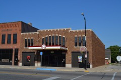 | Avery Theater, The | building | 2008 | 08001043 |
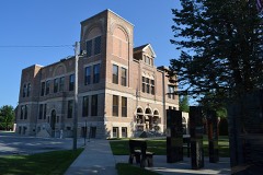 | Hancock County Courthouse | building | 1981 | 81000240 |
| Pilot Knob State Park, Amphitheater (Area 4) | structure | 1990 | 90001688 | |
| Pilot Knob State Park, Observation Tower (Area 2) | building | 1990 | 90001686 | |
| Pilot Knob State Park, Picnic Shelter (Area 3) | building | 1990 | 90001687 | |
| Pilot Knob State Park, Portals (Area 5a) | structure | 1990 | 90001689 | |
| Pilot Knob State Park, Trail Area (Area 6a-6c) | district | 1990 | 90001690 | |
| Pilot Knob State Park: Portals in Area 5b | district | 1995 | 95000362 | |
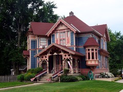 | George E. Stubbins House | building | 1999 | 99000453 |
Every wildfire the federal occurrence database records inside this county: 12 of them, burning about 60 acres. None started naturally and 1 was recorded as arson. Each settlement page carries the fires within five miles of it.
| Reported cause | Fires |
|---|---|
| Missing data/not specified/undetermined | 6 |
| Debris and open burning | 4 |
| Equipment and vehicle use | 1 |
| Arson/incendiarism | 1 |
The five largest, by the area the report gives. One of them was set deliberately.
| Date | Cause | Size | Reported by | Name on the report |
|---|---|---|---|---|
| 11 April 2008 | Arson/incendiarism | 25 acres | Iowa Wetland Management District | EAGLE FLATS |
| 3 February 2006 | Missing data/not specified/undetermined | 15 acres | Iowa Department of Natural Resources | not named |
| 1 November 2006 | Missing data/not specified/undetermined | 5.0 acres | Iowa Department of Natural Resources | not named |
| 5 November 2006 | Missing data/not specified/undetermined | 5.0 acres | Iowa Wetland Management District | RICKE WF |
| 15 April 2014 | Debris and open burning | 2.5 acres | Iowa Department of Natural Resources | not named |
| 23 September 2012 | Debris and open burning | 2.0 acres | Iowa Department of Natural Resources | not named |
| 8 September 2012 | Equipment and vehicle use | 1.5 acres | Iowa Department of Natural Resources | not named |
| 10 October 2012 | Debris and open burning | 1.5 acres | Iowa Department of Natural Resources | not named |
Every settlement page carries the fires within five miles of it - see the settlement index below.
The NOAA Storm Events Database holds 318 reports for this county, causing no deaths, 28 injuries and about $15,127,500 in recorded property damage. Each settlement page carries the reports that name it.
| Kind of event | Reports |
|---|---|
| Thunderstorm Wind | 119 |
| Hail | 114 |
| Heavy Rain | 30 |
| Tornado | 28 |
| Funnel Cloud | 12 |
| Flood | 8 |
| Flash Flood | 5 |
| Lightning | 2 |
The most serious of them, by death, then injury, then recorded damage. The accounts are quoted exactly as the forecast office filed them.
| When | Event | Place named | Harm | What the report says |
|---|---|---|---|---|
| April 1991 | Thunderstorm Wind | not stated | 16 hurt | no account filed |
| June 1951 | Tornado (F2) | not stated | 8 hurt | no account filed |
| May 1953 | Tornado (F4) | not stated | 3 hurt, $250,000 | no account filed |
| June 1999 | Thunderstorm Wind | Corwith | 1 hurt, $25,000 | no account filed |
| June 1984 | Tornado (F2) | not stated | $2,500,000 | no account filed |
| June 1984 | Tornado (F2) | not stated | $2,500,000 | no account filed |
| September 1980 | Tornado (F2) | not stated | $2,500,000 | no account filed |
| April 1967 | Tornado (F2) | not stated | $2,500,000 | no account filed |
| June 1994 | Tornado (F3) | Garner to | $500,000 | no account filed |
| June 1994 | Tornado (F1) | Britt to | $500,000 | no account filed |
| April 1990 | Tornado (F1) | not stated | $250,000 | no account filed |
| July 1984 | Tornado (F1) | not stated | $250,000 | no account filed |
| May 1982 | Tornado (F2) | not stated | $250,000 | no account filed |
| May 1963 | Tornado (F2) | not stated | $250,000 | no account filed |
| June 1998 | Thunderstorm Wind | Britt | $200,000 | no account filed |
| July 2017 | Thunderstorm Wind | Klemme | $150,000 | Storm chaser video depicted extensive wind damage and likely wind driven hail damage in the town of Klemme. Damage included numerous car, home, and business windows broken and trees downed on homes. This is a delayed report and time estimated from radar. |
| June 2014 | Thunderstorm Wind | Miller | $150,000 | Machine shed completely destroyed. Damage to power lines and trees. |
| May 2024 | Thunderstorm Wind | Duncan | $100,000 | Emergency manager reported multiple large trees down, including some on buildings. This is a delayed report and time estimated from radar. |
| March 2019 | Flood | Woden | $100,000 | Iowa DOT reported US 18 closed between Britt and Garner due to flooding. |
| May 2004 | Flash Flood | Countywide | $100,000 | no account filed |
| August 2004 | Hail | Kanawha | $100,000 | no account filed |
| June 1997 | Flash Flood | Garner | $100,000 | no account filed |
| May 2013 | Thunderstorm Wind | Hayfield | $75,000 | Damage just north of Highway 18 along Nash Ave and 260th Street. Lots of 6 inches or larger branches down and a few power poles leaning. Damage to a couple of grain bins and a few metal shed roofs peeled. |
| June 1998 | Flood | Kanawha | $75,000 | no account filed |
| June 2014 | Thunderstorm Wind | Miller | $70,000 | Outbuilding heavily damaged. Debris strewn into a field to the ENE. |
| September 2018 | Flood | Woden | $50,000 | Law enforcement reported some roads closed in rural areas due to water over the road from several rounds of heavy rainfall. Rises also noted local creeks and streams and some overland flooding. |
| May 1998 | Thunderstorm Wind | Garner | $50,000 | no account filed |
| June 1998 | Flood | Britt | $50,000 | no account filed |
| July 1998 | Thunderstorm Wind | Britt | $50,000 | no account filed |
| June 1998 | Flash Flood | Britt | $50,000 | no account filed |
| June 1997 | Tornado (F1) | Britt | $50,000 | no account filed |
| June 1994 | Thunderstorm Wind | Garner | $50,000 | no account filed |
| June 1994 | Thunderstorm Wind | Garner | $50,000 | no account filed |
| July 1994 | Thunderstorm Wind | Garner | $50,000 | no account filed |
| September 2012 | Thunderstorm Wind | Miller | $40,000 | A large metal shed which was bolted to a concrete pad was twisted and ripped from the foundation. |
| April 2001 | Thunderstorm Wind | Corwith | $40,000 | no account filed |
| June 2006 | Lightning | Garner | $30,000 | no account filed |
| July 1995 | Thunderstorm Wind | Britt | $30,000 | no account filed |
| August 2018 | Hail | Garner | $25,000 | Public reported, through local media, hail larger than baseball in size. Time estimated from radar. |
| July 2017 | Thunderstorm Wind | Garner | $25,000 | Storm chaser video depicted extensive wind damage to power poles, including series of snapped poles. This is a delayed report and time estimated from radar. |
| July 2017 | Thunderstorm Wind | Duncan | $25,000 | Emergency manager reported significant wind-driven hail damage to corn and bean fields between Britt and Klemme. Golf ball or larger hail and 70 to 80 mph winds pulverized 5 to 6 foot cornstalks to stubble. Trees and power lines also downed. |
| June 2014 | Flash Flood | Goodell | $25,000 | Many streets in the city were flooded. Many others from Garner to Goodell also had flood waters. |
| June 2013 | Thunderstorm Wind | Hayfield | $25,000 | A half mile wide swath of wind damage was reported. A number of 8 inch diameter branches were broken and a large tree was down over the road. |
| July 2013 | Hail | Garner | $25,000 | The golf ball size hail was reported on Henchen Street. |
| July 2007 | Thunderstorm Wind | Garner | $25,000 | no account filed |
| June 2007 | Hail | Corwith | $25,000 | no account filed |
| June 2007 | Hail | Corwith | $25,000 | no account filed |
| August 2004 | Hail | Kanawha | $25,000 | no account filed |
| September 2001 | Hail | Garner | $25,000 | no account filed |
| August 2000 | Thunderstorm Wind | Corwith | $25,000 | no account filed |
| June 1998 | Thunderstorm Wind | Kanawha | $25,000 | no account filed |
| June 1980 | Tornado (F1) | not stated | $25,000 | no account filed |
| September 1973 | Tornado (F1) | not stated | $25,000 | no account filed |
| September 1973 | Tornado (F2) | not stated | $25,000 | no account filed |
| April 2022 | Tornado (EF0) | Kanawha | $20,000 | The tornado developed just west of Iowa Avenue south of 120th Street west of Kanawha and immediately produced minor damage to outbuildings. The tornado continued east northeast and grazed the northwest edge of Kanawha with tree branches downed along with minor damage to a few houses, mainly from missing shingles. The tornado dissipated not far northeast of the town. |
| September 2018 | Thunderstorm Wind | Garner | $20,000 | Hancock County Sheriff reported power lines down. |
| May 2017 | Thunderstorm Wind | Garner | $20,000 | Public reported a large tree fell on a house and damage was done to a fence in town. Tree was 1 to 2 feet in diameter. Reported via social media and is a delayed report. |
| June 2015 | Thunderstorm Wind | Kanawha | $20,000 | Public reported trees snapped in town. Report came via social media and time radar estimated. |
| June 2006 | Thunderstorm Wind | Corwith | $20,000 | no account filed |
| April 2001 | Thunderstorm Wind | Corwith | $20,000 | no account filed |
The Survey's mineral resources record lists 46 workings inside this county. 13 still produce and 33 are closed or unrecorded. Each settlement page carries the workings within five miles of it.
| Commodity | Workings |
|---|---|
| Sand and Gravel, Construction | 41 |
| Stone, Crushed/Broken | 5 |
The least common of them first, because a county's hundredth gravel pit says nothing its first ten did not.
| Where | Site | Commodity | Status | Recorded |
|---|---|---|---|---|
| Andrews Quarry | Stone, Crushed/Broken | Producer | ||
| Garner Quarry | Stone, Crushed/Broken | Past Producer | ||
| Garner Quarry | Stone, Crushed/Broken | Past Producer | ||
| Garner Quarry & Mill | Stone, Crushed/Broken | Producer | ||
| Garner Reuber Quarry | Stone, Crushed/Broken | Past Producer | ||
| Austin Pit | Sand and Gravel, Construction | Past Producer | ||
| City Dump | Sand and Gravel, Construction | Past Producer | ||
| Eight Mile Pit | Sand and Gravel, Construction | Producer | ||
| Friedman Pit | Sand and Gravel, Construction | Past Producer | ||
| Greiman Pit | Sand and Gravel, Construction | Unknown | ||
| Hanson Pit | Sand and Gravel, Construction | Producer | ||
| Harms Riherd Pit | Sand and Gravel, Construction | Producer | ||
| Hutchins Pits | Sand and Gravel, Construction | Producer | ||
| Kirschbaum Pit | Sand and Gravel, Construction | Past Producer | ||
| Klemme Pit | Sand and Gravel, Construction | Producer | ||
| Laharve Pit | Sand and Gravel, Construction | Producer | ||
| Mezvinsky Pit | Sand and Gravel, Construction | Past Producer | ||
| Miller Pit | Sand and Gravel, Construction | Unknown | ||
| Ruka Pit | Sand and Gravel, Construction | Unknown | ||
| Sankey Pit and Plant | Sand and Gravel, Construction | Producer | ||
| Schimmelpfenning Pit | Sand and Gravel, Construction | Past Producer | ||
| Sec 32 Sw4 Pit | Sand and Gravel, Construction | Producer | ||
| Teget Pit | Sand and Gravel, Construction | Past Producer | ||
| Torkelson Pit | Sand and Gravel, Construction | Producer | ||
| Torkelson Pit | Sand and Gravel, Construction | Producer | ||
| Unknown | Sand and Gravel, Construction | Unknown | ||
| Unknown | Sand and Gravel, Construction | Past Producer | ||
| Unknown | Sand and Gravel, Construction | Unknown | ||
| Unknown | Sand and Gravel, Construction | Unknown | ||
| Unknown | Sand and Gravel, Construction | Past Producer | ||
| Unknown | Sand and Gravel, Construction | Unknown | ||
| Unknown | Sand and Gravel, Construction | Past Producer | ||
| Unknown | Sand and Gravel, Construction | Unknown | ||
| Unknown | Sand and Gravel, Construction | Past Producer | ||
| Unknown | Sand and Gravel, Construction | Unknown | ||
| Unknown | Sand and Gravel, Construction | Past Producer | ||
| Unknown | Sand and Gravel, Construction | Past Producer | ||
| Unknown | Sand and Gravel, Construction | Unknown | ||
| Unknown | Sand and Gravel, Construction | Past Producer | ||
| Unknown | Sand and Gravel, Construction | Past Producer | ||
| Unknown | Sand and Gravel, Construction | Unknown | ||
| Unknown | Sand and Gravel, Construction | Past Producer | ||
| Unknown | Sand and Gravel, Construction | Unknown | ||
| Unknown | Sand and Gravel, Construction | Unknown | ||
| Unknown | Sand and Gravel, Construction | Producer | ||
| Welch Property | Sand and Gravel, Construction | Unknown |
Named settlements recorded in the Geographic Names Information System, each with the topographic sheets covering it. Villages, hamlets and abandoned places alike. Each is shown with the nearest named watercourse or landform and the survey quadrangle it falls on.