 Block
From the record
7 National Register listings published here.
Sources: the National Register database, National Park Service
30 topographic sheets cover 15 settlements here, and 7 properties are on the National Register of Historic Places.
7 National Register listings published here.
Sources: the National Register database, National Park Service
Every property in this county listed on the National Register of Historic Places, with the year it was listed and the federal nomination document.
| Photograph | Property | Type | Listed | Reference |
|---|---|---|---|---|
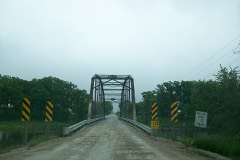 | Berkhimer Bridge | structure | 1998 | 98000523 |
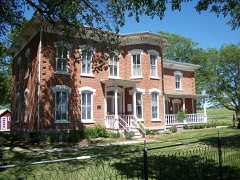 | Corydon Brown House | building | 1978 | 78001223 |
| Des Moines River Bridge | structure | 1998 | 98000522 | |
 | Humboldt County Court House | building | 2003 | 03000823 |
 | Humboldt Free Public Library | building | 1983 | 83000368 |
 | Renwick Generating Plant | district | 1995 | 95000099 |
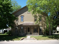 | Stephen Harris Taft House | building | 2002 | 02001601 |
Every wildfire the federal occurrence database records inside this county: 7 of them, burning about 63 acres. None started naturally and none was recorded as arson. Each settlement page carries the fires within five miles of it.
| Reported cause | Fires |
|---|---|
| Missing data/not specified/undetermined | 5 |
| Debris and open burning | 1 |
| Smoking | 1 |
The five largest, by the area the report gives. None of them was recorded as arson.
| Date | Cause | Size | Reported by | Name on the report |
|---|---|---|---|---|
| 8 April 2006 | Missing data/not specified/undetermined | 25 acres | Iowa Department of Natural Resources | not named |
| 3 October 2012 | Smoking | 15 acres | Iowa Department of Natural Resources | not named |
| 30 March 2011 | Missing data/not specified/undetermined | 15 acres | Iowa Department of Natural Resources | 100TH & 130TH, IA |
| 11 April 2009 | Missing data/not specified/undetermined | 5.0 acres | Iowa Department of Natural Resources | not named |
| 21 March 2009 | Missing data/not specified/undetermined | 2.0 acres | Iowa Department of Natural Resources | not named |
| 7 November 2010 | Missing data/not specified/undetermined | 1.0 acres | Iowa Department of Natural Resources | 1718 120TH ST., IOWA |
| 25 May 2012 | Debris and open burning | under an acre | Iowa Department of Natural Resources | not named |
Every settlement page carries the fires within five miles of it - see the settlement index below.
The NOAA Storm Events Database holds 312 reports for this county, causing no deaths, 37 injuries and about $10,568,000 in recorded property damage. Each settlement page carries the reports that name it.
| Kind of event | Reports |
|---|---|
| Hail | 102 |
| Thunderstorm Wind | 93 |
| Flood | 48 |
| Tornado | 26 |
| Heavy Rain | 21 |
| Flash Flood | 11 |
| Funnel Cloud | 10 |
| Lightning | 1 |
The most serious of them, by death, then injury, then recorded damage. The accounts are quoted exactly as the forecast office filed them.
| When | Event | Place named | Harm | What the report says |
|---|---|---|---|---|
| September 2010 | Flood | Humboldt Muni Arpt | 20 hurt, $5,000 | no account filed |
| May 2004 | Tornado (F2) | Bradgate | 15 hurt, $2,500,000 | Tornado intensified as it approached Bradgate. Seventy five percent of the town was damaged or destroyed by the tornado which was one half mile wide as it moved through. |
| June 1981 | Tornado (F2) | not stated | 1 hurt, $25,000 | no account filed |
| June 2007 | Lightning | Dakota City | 1 hurt | no account filed |
| June 1984 | Tornado (F2) | not stated | $2,500,000 | no account filed |
| June 2010 | Flood | Humboldt Muni Arpt | $300,000 | Many basements flooded in Humboldt. Also bridge under water north of town on Highway 169. |
| June 2018 | Flood | St Joseph | $250,000 | Flooding was reported in the county with two roads still closed near Livermore. Deep washouts had occurred on some county roads in the northeastern portion of the county. |
| June 1979 | Tornado (F1) | not stated | $250,000 | no account filed |
| March 2019 | Flood | Ottosen | $200,000 | Multiple secondary roads were closed across the county from snowmelt and heavy rain during the period. In addition an ice jam around Humboldt and Dakota City were causing flooding during the period. |
| July 2010 | Thunderstorm Wind | Dakota City | $200,000 | Local law enforcement reports large limbs down across Humboldt County as well as large trees broken and uprooted near the county fairgrounds. |
| June 2010 | Flood | Humboldt Muni Arpt | $200,000 | no account filed |
| April 2022 | Tornado (EF1) | Unique | $100,000 | This tornado had an unusual path with a fishhook shaped track. The tornado started to the northwest just south of 230th Street between Elm and Florida Avenues. The tornado produced EF1 damage at a farmstead on the south side of 230th street, mostly to trees. The tornado began to loop northward along Elm Avenue producing damage at a couple of farms. The tornado continued to curve toward the northeast and eventually an east northeast heading ending a little over a mile southwest of Rutland, IA. |
| May 2019 | Flood | Dakota City | $100,000 | The West Fork of the Des Moines River at Humboldt crested at 10.58 feet on 25 May 2019 at 23:30 UTC. |
| May 2019 | Flood | Dakota City | $100,000 | The West Fork of the Des Moines River at Humboldt crested at 10.36 feet on 2 May 2019 at 06:15 UTC. |
| April 2018 | Flood | Dakota City | $100,000 | The West Fork of the Des Moines River at Humboldt crested at 10.72 feet on 26 April 2018 at 10:15 UTC. |
| May 2018 | Thunderstorm Wind | Thor | $100,000 | Trained spotter reported several large tree limbs and even a few trees snapped at the base throughout the town of Thor. One tree was roughly 18 inches in diameter and about 50 feet tall and snapped at the base. Some houses had trees that fell on their roof, unknown extent of damage at the time. Time was estimated from radar. |
| June 2018 | Flood | Dakota City | $100,000 | The West Fork of the Des Moines River at Humboldt crested twice through the period of flooding. The river remained in flood into July. The first crest was at 12.35 feet on 24 June 2018 at 23:30 UTC, and the second one was at 12.64 feet on 28 June 2018 at 16:15 UTC. |
| June 2018 | Flash Flood | Livermore | $100,000 | Emergency manager reported water in basements along with street flooding in Livermore. |
| July 2018 | Flood | Dakota City | $100,000 | The West Fork of the Des Moines River at Humboldt went into flood in late June and remained in flood through much of July. The river crested 3 times in July. The first crest at 12.83 feet on 1 July 2018 at 18:15Z, the second crest at 13.5 feet on 7 July 2018 at 02:15 UTC, and the third crest at 12.04 feet on 15 July 2018 at 08:15 UTC. |
| September 2018 | Flood | Dakota City | $100,000 | The West Fork of the Des Moines River at Humboldt crested at 12.83 feet on 23 September 2018 at 0400 UTC. |
| July 2016 | Thunderstorm Wind | Renwick | $100,000 | Law Enforcement reported one-third of a roof gone from an implement and farm supply store. Additionally, a camper on its side, multiple power lines down, and large trees down throughout town blocking numerous streets. A grain bin was also reported collapsed at the Co-op. |
| July 2010 | Thunderstorm Wind | Dakota City | $100,000 | Humboldt County sheriff reported 70 to 80 MPH winds in town. |
| August 2007 | Flash Flood | Pioneer | $100,000 | Road were closed due to water running over them and basements flooded due to the heavy rain. |
| June 2011 | Flood | Humboldt Muni Arpt | $100,000 | no account filed |
| July 2010 | Flood | Humboldt Muni Arpt | $100,000 | no account filed |
| April 2008 | Flood | Pioneer | $100,000 | no account filed |
| May 2004 | Flash Flood | Countywide | $100,000 | no account filed |
| July 2000 | Flash Flood | North Portion | $100,000 | no account filed |
| May 1998 | Thunderstorm Wind | Ottosen | $100,000 | no account filed |
| June 1997 | Hail | Humboldt | $100,000 | no account filed |
| June 2024 | Flood | Dakota City | $88,000 | The West Fork of the Des Moines at Humboldt crested at 16.99 ft on June 27 at 02:15 am CDT. The river remained in flood through the end of the month and into July. Preliminary information indicates this is the new flood of record for the point. |
| April 2022 | Tornado (EF2) | Rutland | $75,000 | This tornado also had a fishhook shape with the initial touchdown captured on video providing evidence of its northwest heading. This occurred just north of 180th Street west of Georgia Avenue. The tornado had more of a north heading upon crossing 170th Street and impacted a couple of farmstead, producing EF1 damage. The tornado continued to curve counter-clockwise eventually reaching a northeast heading. Upon crossing Iowa Avenue just north of 145th Street, numerous sizeable power poles were snapped with EF2 damage occurring. The tornado diminished about one and a quarter mile southeast of Bode, IA. |
| May 2011 | Flood | Humboldt Muni Arpt | $75,000 | no account filed |
| October 2018 | Flood | Dakota City | $50,000 | The West Fork of the Des Moines River at Humboldt crested at 10.11 ft on 12 October 2018 at 17:00 UTC. |
| May 2017 | Hail | Thor | $50,000 | Public reported just smaller than baseball sized hail. This is a delayed report, and from social media. Many car windows broken at a school event. |
| July 2016 | Thunderstorm Wind | Thor | $50,000 | Emergency Manager reported 4 machine sheds damaged/destroyed. Time estimated from radar. |
| June 2015 | Thunderstorm Wind | Dakota City | $50,000 | Emergency Manager reported lots of large trees down, a mobile home moved from its foundation, tree limbs blown through a porch, grain bin blown over, power poles blown over, and large tree limbs down. |
| June 2014 | Flash Flood | Ottosen | $50,000 | Numerous roads were closed throughout Humboldt County due to standing or flowing water. The worst impacts were over the northwest part of the county. |
| May 2012 | Thunderstorm Wind | Dakota City | $50,000 | Several trees and large limbs down across Humboldt. One tree fell onto a house. |
| May 2012 | Thunderstorm Wind | Dakota City | $50,000 | A tourist building was damaged in town from the gusty winds. |
| August 2007 | Flash Flood | Rutland | $50,000 | A care center was evacuated by emergency personnel in Humboldt. |
| August 2007 | Thunderstorm Wind | Bradgate | $50,000 | High winds blew down outbuildings, grain bins, and trees. |
| March 2011 | Flood | Humboldt Muni Arpt | $50,000 | no account filed |
| March 2010 | Flood | Humboldt Muni Arpt | $50,000 | no account filed |
| April 2010 | Flood | Humboldt Muni Arpt | $50,000 | no account filed |
| June 2008 | Flood | Humboldt Muni Arpt | $50,000 | no account filed |
| August 2007 | Flood | Humboldt Muni Arpt | $50,000 | no account filed |
| August 2007 | Thunderstorm Wind | Bode | $50,000 | no account filed |
| March 2007 | Flood | Humboldt | $50,000 | no account filed |
| June 1998 | Flood | Dakota City | $50,000 | no account filed |
| June 2007 | Hail | Renwick | $40,000 | no account filed |
| August 2002 | Thunderstorm Wind | Humboldt | $40,000 | no account filed |
| December 2021 | Tornado (EF1) | Rutland | $30,000 | This tornado started a few miles northwest of Rutland and moved northeast through rural portions of Humboldt County. The tornado snapped several large utility poles along Iowa Avenue south of Bode before lifting. |
| June 2015 | Thunderstorm Wind | Dakota City | $30,000 | Emergency Manager reported widespread trees and power lines down within the city. Time radar estimated. |
| June 2015 | Thunderstorm Wind | Rutland | $30,000 | Emergency Manager reported tree damage and equipment blown around in the yard. Tin siding was pulled from the outbuildings. |
| June 2018 | Flash Flood | Livermore | $25,000 | County Sheriff's Office reported multiple roads covered in and around Livermore. |
| June 2011 | Thunderstorm Wind | Ottosen | $25,000 | Power lines and trees blown down. Winds estimated 80 MPH. Pea size hail was also reported. |
| July 2010 | Thunderstorm Wind | Dakota City | $25,000 | Trained spotter estimated wind of 70 MPH. |
| October 2010 | Flood | Humboldt Muni Arpt | $25,000 | no account filed |
| March 2010 | Flood | Brock Ranch Arpt | $25,000 | no account filed |
The Survey's mineral resources record lists 26 workings inside this county. 7 still produce and 19 are closed or unrecorded. Each settlement page carries the workings within five miles of it.
| Commodity | Workings |
|---|---|
| Sand and Gravel, Construction | 18 |
| Stone, Crushed/Broken | 8 |
The least common of them first, because a county's hundredth gravel pit says nothing its first ten did not.
| Where | Site | Commodity | Status | Recorded |
|---|---|---|---|---|
| Bradgate Quarry | Stone, Crushed/Broken | Unknown | ||
| Erickson | Stone, Crushed/Broken | Past Producer | ||
| Griffith Quarry | Stone, Crushed/Broken | Producer | ||
| Hodges Quarry and Mill | Stone, Crushed/Broken | Producer | ||
| Humboldt Quarry | Stone, Crushed/Broken | Past Producer | ||
| Rutland Quarry | Stone, Crushed/Broken | Past Producer | ||
| Rutland Quarry and Mill | Stone, Crushed/Broken | Past Producer | ||
| Unknown | Stone, Crushed/Broken | Unknown | ||
| Bradgate Pit | Sand and Gravel, Construction | Past Producer | ||
| Bradgate Pit | Sand and Gravel, Construction | Past Producer | ||
| Foster Pit | Sand and Gravel, Construction | Past Producer | ||
| Frank Gotch State Park | Sand and Gravel, Construction | Past Producer | ||
| Hallett Pit | Sand and Gravel, Construction | Unknown | ||
| Humboldt Pit | Sand and Gravel, Construction | Past Producer | ||
| Humboldt Pit and Plant | Sand and Gravel, Construction | Producer | ||
| Peterson Pit | Sand and Gravel, Construction | Producer | ||
| Unknown | Sand and Gravel, Construction | Producer | ||
| Unknown | Sand and Gravel, Construction | Unknown | ||
| Unknown | Sand and Gravel, Construction | Producer | ||
| Unknown | Sand and Gravel, Construction | Unknown | ||
| Unknown | Sand and Gravel, Construction | Past Producer | ||
| Unknown | Sand and Gravel, Construction | Past Producer | ||
| Unknown | Sand and Gravel, Construction | Unknown | ||
| Unknown | Sand and Gravel, Construction | Producer | ||
| Unknown | Sand and Gravel, Construction | Past Producer | ||
| Zeidler Pit | Sand and Gravel, Construction | Past Producer |
Named settlements recorded in the Geographic Names Information System, each with the topographic sheets covering it. Villages, hamlets and abandoned places alike. Each is shown with the nearest named watercourse or landform and the survey quadrangle it falls on.
Corinth township · 50548 · On Indian Creek · Humboldt quadrangle
11 sheets, 1923 to 1984