 Block
From the record
6 National Register listings published here.
Sources: the National Register database, National Park Service
38 topographic sheets cover 26 settlements here, and 6 properties are on the National Register of Historic Places.
6 National Register listings published here.
Sources: the National Register database, National Park Service
Every property in this county listed on the National Register of Historic Places, with the year it was listed and the federal nomination document.
| Photograph | Property | Type | Listed | Reference |
|---|---|---|---|---|
| Algona Junior and Senior High School Building and High School Building Annex | building | 2014 | 14001006 | |
| William C. and Hertha Dau House | building | 1993 | 93000654 | |
| Des Moines River Bridge | structure | 1998 | 98000535 | |
| G.A.R. Memorial Hall | building | 2014 | 13001077 | |
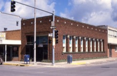 | Land and Loan Office Building | building | 1998 | 98000250 |
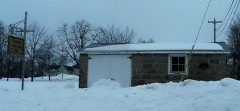 | Lu Verne City Jail | building | 1992 | 92001662 |
Every wildfire the federal occurrence database records inside this county: 49 of them, burning about 444 acres. 1 started naturally and 2 were recorded as arson. Each settlement page carries the fires within five miles of it.
| Reported cause | Fires |
|---|---|
| Missing data/not specified/undetermined | 33 |
| Debris and open burning | 9 |
| Recreation and ceremony | 3 |
| Arson/incendiarism | 2 |
| Natural | 1 |
| Equipment and vehicle use | 1 |
The five largest, by the area the report gives. None of them was recorded as arson.
| Date | Cause | Size | Reported by | Name on the report |
|---|---|---|---|---|
| 4 March 2009 | Missing data/not specified/undetermined | 60 acres | Iowa Department of Natural Resources | not named |
| 26 March 2007 | Debris and open burning | 50 acres | Union Slough National Wildlife Refuge | REUTZEL |
| 1 December 2017 | Missing data/not specified/undetermined | 40 acres | Union Slough National Wildlife Refuge | UNIT 4 WILDFIRE 17 |
| 10 December 2010 | Missing data/not specified/undetermined | 35 acres | Iowa Department of Natural Resources | 1975 220TH AVE, IOWA |
| 6 April 2003 | Missing data/not specified/undetermined | 33 acres | Union Slough National Wildlife Refuge | VP SOUTH WILDFIRE |
| 1 April 2003 | Missing data/not specified/undetermined | 28 acres | Union Slough National Wildlife Refuge | DEER MEADOW WILDFIRE |
| 17 March 2009 | Missing data/not specified/undetermined | 27 acres | Iowa Department of Natural Resources | not named |
| 30 March 2011 | Missing data/not specified/undetermined | 15 acres | Iowa Department of Natural Resources | 100TH & 130TH, IA |
Every settlement page carries the fires within five miles of it - see the settlement index below.
The NOAA Storm Events Database holds 568 reports for this county, causing 2 deaths, 42 injuries and about $70,681,000 in recorded property damage. Each settlement page carries the reports that name it.
| Kind of event | Reports |
|---|---|
| Hail | 197 |
| Thunderstorm Wind | 184 |
| Heavy Rain | 61 |
| Tornado | 39 |
| Flood | 39 |
| Flash Flood | 24 |
| Funnel Cloud | 21 |
| Lightning | 3 |
The most serious of them, by death, then injury, then recorded damage. The accounts are quoted exactly as the forecast office filed them.
| When | Event | Place named | Harm | What the report says |
|---|---|---|---|---|
| June 1979 | Tornado (F3) | not stated | 2 killed, 34 hurt, $25,000,000 | no account filed |
| June 1984 | Tornado (F3) | not stated | 5 hurt, $25,000,000 | no account filed |
| August 1964 | Tornado (F4) | not stated | 2 hurt, $250,000 | no account filed |
| June 1984 | Tornado (F2) | not stated | 1 hurt, $2,500,000 | no account filed |
| June 1984 | Tornado (F2) | not stated | $2,500,000 | no account filed |
| July 1980 | Tornado (F2) | not stated | $2,500,000 | no account filed |
| September 1980 | Tornado (F2) | not stated | $2,500,000 | no account filed |
| May 1998 | Tornado (F2) | Algona | $1,000,000 | Intermittent track |
| June 2008 | Flood | Burt | $1,000,000 | no account filed |
| July 2000 | Flash Flood | South Portion | $500,000 | no account filed |
| May 1998 | Thunderstorm Wind | Bancroft | $500,000 | no account filed |
| May 1998 | Thunderstorm Wind | Algona | $350,000 | no account filed |
| June 2018 | Flood | Whittemore | $250,000 | Water was flooding portions of Whittemore with sewage backing up into homes. Water continued to flow across portions of Hwy 18 in Kossuth County. |
| March 2010 | Flood | Burt | $250,000 | no account filed |
| May 1998 | Thunderstorm Wind | Bancroft | $250,000 | no account filed |
| July 1987 | Tornado (F1) | not stated | $250,000 | no account filed |
| June 1979 | Tornado (F1) | not stated | $250,000 | no account filed |
| June 1974 | Tornado (F2) | not stated | $250,000 | no account filed |
| June 2011 | Tornado (EF1) | St Joseph | $200,000 | Surveyed by the EM. A house had walls blown in and out, part of the roof was off the house. A motor from a grain auger was launched into the attic of the house with grain bins and trees down. A convergent debris path was present north-northwest of the house with no damage on the west side of the farmstead. A short track tornadic damage path was present with an area of straight line wind damage at other farms within 2 miles. |
| April 2011 | Tornado (EF1) | St Joseph | $150,000 | Short duration tornado that produced damage to a hog confinement building. |
| June 2008 | Flood | Hobarton | $150,000 | County Blacktop R14 under water south of Wesley. More than 40 gravel roads in county impacted. |
| June 2024 | Flood | Lu Verne | $128,000 | The East Fork of the Des Moines at Algona crested at 20.73 ft on June 23 at 05:15 am CDT. The river remained in flood through the end of the month and into July. |
| June 1998 | Flash Flood | Algona | $120,000 | no account filed |
| September 2019 | Thunderstorm Wind | Swea City | $100,000 | Emergency Manager reported power lines, grain bins, residential and farm building damage damaged or destroyed, heavy tree damage, and an emergency communication tower destroyed. |
| June 2018 | Flood | Lu Verne | $100,000 | The East Fork of the Des Moines River at Algona crested twice through the period of flooding. The first crest was 18.69 feet on 22 June 2018 at 22:15 UTC, the second crest was 19.33 feet on 26 June 2018 at 10:45 UTC. |
| June 2018 | Flood | Fenton | $100,000 | Flooding was reported in Whittemore with some high stream flows along Hwy 169 near 130th street south of Algona. Flooding continued across portions of southern Kossuth County as well. |
| September 2018 | Flood | Lu Verne | $100,000 | The East Fork of the Des Moines River at Algona crested at 19.16 feet on 22 September 2018 at 1915 UTC. |
| May 2017 | Thunderstorm Wind | Algona | $100,000 | Numerous downed trees some up to 18 inches in diameter across the county, some buildings damaged and numerous power lines down. A railroad crossing arm was snapped off and a garage was destroyed in Whittemore, some outbuildings and a house were damaged near town as well. Agricultural impacts as well with machinery blown over, bent up and also seed loss. |
| June 2014 | Flash Flood | Lotts Creek | $100,000 | Almost all streets in town were under water due to the combination of three inches of rain and the sewer system being overwhelmed. Many homes and businesses had water in the basement. |
| February 2011 | Flood | Burt | $100,000 | no account filed |
| June 2011 | Flood | Burt | $100,000 | no account filed |
| August 2006 | Flash Flood | Algona | $100,000 | no account filed |
| May 2004 | Flash Flood | South Portion | $100,000 | no account filed |
| May 1999 | Thunderstorm Wind | Irvington | $100,000 | no account filed |
| May 1998 | Thunderstorm Wind | Titonka | $100,000 | no account filed |
| April 2013 | Thunderstorm Wind | Whittemore | $75,000 | A barn and outbuilding destroyed. |
| October 2013 | Thunderstorm Wind | Fenton | $75,000 | High transmission power poles were down along highway 15. |
| June 2009 | Thunderstorm Wind | Lu Verne | $75,000 | Kossuth County EM reports a swath of wind damage from Lu Verne extending 6 miles west and 4 miles north. Trees and power lines were downed and crops were flattened. |
| April 2010 | Flood | Burt | $75,000 | no account filed |
| July 1998 | Thunderstorm Wind | Algona | $75,000 | no account filed |
| June 2018 | Flash Flood | Algona Muni Arpt | $50,000 | Emergency manager reported water over roadways in town, Highway 18 closed at Highway 169, and Highway 169 closed south of town. |
| September 2018 | Flood | Seneca | $50,000 | Law enforcement reported some roads closed in rural areas due to water over the road from several rounds of heavy rainfall. Rises also noted local creeks and streams and some overland flooding. |
| September 2018 | Flash Flood | Algona | $50,000 | Iowa DOT reported road closure between County Highway B55 and US 18 due to water over the road. |
| July 2016 | Thunderstorm Wind | Algona | $50,000 | Kossuth County Emergency Manager reported extensive tree damage across the entire county due to straight line winds. Specifically Burt, Algona, Swea City, Luverne, and Bancroft were mentioned in the report. |
| June 2015 | Thunderstorm Wind | St Benedict | $50,000 | Emergency Manager reported large trees of around 1 to 2 feet in diameter down, tree branches down, and power poles down in Wesley and St. Benedict. |
| October 2013 | Thunderstorm Wind | Lone Rock | $50,000 | Multiple trees and branches were blown down. Power poles were blown down. The tops of trees were sheared off on a farm near Lone Rock with crop damage reported. |
| April 2011 | Hail | Algona | $50,000 | A funnel cloud was also reported. |
| July 2011 | Thunderstorm Wind | Burt | $50,000 | A listener reported telephone poles down, damage to a building, and possibly a trailer. Relayed by KLGA radio. |
| August 2011 | Thunderstorm Wind | Algona | $50,000 | Considerable tree damage in town. Many roads impassable. |
| June 2011 | Thunderstorm Wind | St Joseph | $50,000 | Surveyed by EM and found three fourths of a grove of trees were downed. Shingle damage also occurred with debris strewn north. |
| June 2008 | Flash Flood | Wesley | $50,000 | Extensive flooding reported in Wesley, blocking access to the area. |
| May 2014 | Thunderstorm Wind | Algona Muni Arpt | $50,000 | no account filed |
| May 2011 | Flood | Burt | $50,000 | no account filed |
| June 2010 | Flood | Burt | $50,000 | no account filed |
| July 2010 | Flood | Burt | $50,000 | no account filed |
| October 2007 | Flood | Algona | $50,000 | no account filed |
| March 2007 | Flood | Algona | $50,000 | no account filed |
| June 2004 | Flash Flood | Countywide | $50,000 | no account filed |
| May 1998 | Hail | Algona | $50,000 | no account filed |
| July 1997 | Thunderstorm Wind | Sexton | $50,000 | no account filed |
The Survey's mineral resources record lists 61 workings inside this county. 6 still produce and 55 are closed or unrecorded. Each settlement page carries the workings within five miles of it.
| Commodity | Workings |
|---|---|
| Sand and Gravel, Construction | 60 |
| Clay | 1 |
The least common of them first, because a county's hundredth gravel pit says nothing its first ten did not.
| Where | Site | Commodity | Status | Recorded |
|---|---|---|---|---|
| Unknown | Clay | Past Producer | ||
| Bartosh Pit | Sand and Gravel, Construction | Past Producer | ||
| Basselor Pit | Sand and Gravel, Construction | Past Producer | ||
| Corn Pit | Sand and Gravel, Construction | Unknown | ||
| Dole | Sand and Gravel, Construction | Producer | ||
| Ensle Pit | Sand and Gravel, Construction | Past Producer | ||
| Frankel Pit | Sand and Gravel, Construction | Past Producer | ||
| Goche Pit | Sand and Gravel, Construction | Past Producer | ||
| Grill Pit | Sand and Gravel, Construction | Past Producer | ||
| Heusinkveld Pit | Sand and Gravel, Construction | Producer | ||
| Hoien Gravel Pit | Sand and Gravel, Construction | Past Producer | ||
| Insko Pit | Sand and Gravel, Construction | Past Producer | ||
| Irvington | Sand and Gravel, Construction | Past Producer | ||
| Irvington Pit | Sand and Gravel, Construction | Producer | ||
| Mark T Mcguire Custom Grading Pit#1 | Sand and Gravel, Construction | Producer | ||
| Reding Pit | Sand and Gravel, Construction | Past Producer | ||
| Roethler | Sand and Gravel, Construction | Past Producer | ||
| Sec Ii T94 R29 Pit | Sand and Gravel, Construction | Producer | ||
| Seneca Pit | Sand and Gravel, Construction | Past Producer | ||
| Siems County Park | Sand and Gravel, Construction | Past Producer | ||
| Unknown | Sand and Gravel, Construction | Past Producer | ||
| Unknown | Sand and Gravel, Construction | Past Producer | ||
| Unknown | Sand and Gravel, Construction | Past Producer | ||
| Unknown | Sand and Gravel, Construction | Unknown | ||
| Unknown | Sand and Gravel, Construction | Past Producer | ||
| Unknown | Sand and Gravel, Construction | Past Producer | ||
| Unknown | Sand and Gravel, Construction | Past Producer | ||
| Unknown | Sand and Gravel, Construction | Past Producer | ||
| Unknown | Sand and Gravel, Construction | Past Producer | ||
| Unknown | Sand and Gravel, Construction | Past Producer | ||
| Unknown | Sand and Gravel, Construction | Past Producer | ||
| Unknown | Sand and Gravel, Construction | Unknown | ||
| Unknown | Sand and Gravel, Construction | Past Producer | ||
| Unknown | Sand and Gravel, Construction | Unknown | ||
| Unknown | Sand and Gravel, Construction | Unknown | ||
| Unknown | Sand and Gravel, Construction | Past Producer | ||
| Unknown | Sand and Gravel, Construction | Past Producer | ||
| Unknown | Sand and Gravel, Construction | Past Producer | ||
| Unknown | Sand and Gravel, Construction | Past Producer | ||
| Unknown | Sand and Gravel, Construction | Past Producer | ||
| Unknown | Sand and Gravel, Construction | Unknown | ||
| Unknown | Sand and Gravel, Construction | Unknown | ||
| Unknown | Sand and Gravel, Construction | Unknown | ||
| Unknown | Sand and Gravel, Construction | Unknown | ||
| Unknown | Sand and Gravel, Construction | Unknown | ||
| Unknown | Sand and Gravel, Construction | Past Producer | ||
| Unknown | Sand and Gravel, Construction | Past Producer | ||
| Unknown | Sand and Gravel, Construction | Past Producer | ||
| Unknown | Sand and Gravel, Construction | Past Producer | ||
| Unknown | Sand and Gravel, Construction | Past Producer | ||
| Unknown | Sand and Gravel, Construction | Past Producer | ||
| Unknown | Sand and Gravel, Construction | Past Producer | ||
| Unknown | Sand and Gravel, Construction | Past Producer | ||
| Unknown | Sand and Gravel, Construction | Past Producer | ||
| Whittemore Pit | Sand and Gravel, Construction | Producer |
Named settlements recorded in the Geographic Names Information System, each with the topographic sheets covering it. Villages, hamlets and abandoned places alike. Each is shown with the nearest named watercourse or landform and the survey quadrangle it falls on.
Springfield township · 50556 · Ledyard quadrangle
7 sheets, 1954 to 1985
No longer a settlement
Buffalo township · 50480 · On Little Buffalo Creek · Titonka quadrangle
7 sheets, 1954 to 1985
The vanished settlements of Kossuth County: the places named above that are no longer on the map.