 Block
From the record
16 National Register listings published here.
Sources: the National Register database, National Park Service
35 topographic sheets cover 16 settlements here, and 16 properties are on the National Register of Historic Places.
16 National Register listings published here.
Sources: the National Register database, National Park Service
Every property in this county listed on the National Register of Historic Places, with the year it was listed and the federal nomination document.
| Photograph | Property | Type | Listed | Reference |
|---|---|---|---|---|
| Burlington Railroad Overpass | structure | 1998 | 98000511 | |
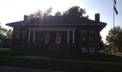 | Caviness, Carl L., Post 102, American Legion | building | 2006 | 06000773 |
 | Chariton Cemetery Historic District | district | 2010 | 10000054 |
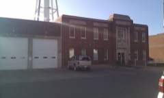 | Chariton City Hall and Fire Station | building | 2006 | 06000775 |
 | Chariton Free Public Library | building | 2005 | 05000906 |
 | Chariton Herald-Patriot Building | building | 2006 | 06000776 |
 | Chariton Masonic Temple | building | 2006 | 06000777 |
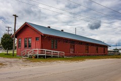 | Chicago, Burlington, and Quincy Freight House-Chariton | building | 2003 | 03000836 |
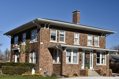 | J.T. and Mollie Crozier House | building | 2011 | 11000721 |
 | First United Methodist Church | building | 2002 | 01001485 |
 | Hotel Charitone | building | 2006 | 06000774 |
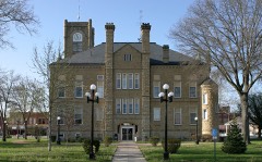 | Lucas County Courthouse | building | 1981 | 81000254 |
 | Lucas County Courthouse Square Historic District | district | 2014 | 14000324 |
 | O. E. Payne House | building | 1979 | 79000912 |
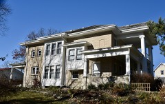 | A. J. Stephens House | building | 1987 | 87002020 |
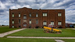 | Williamson School | building | 1998 | 98000374 |
Every wildfire the federal occurrence database records inside this county: 110 of them, burning about 2,458 acres. None started naturally and none was recorded as arson. Each settlement page carries the fires within five miles of it.
| Reported cause | Fires |
|---|---|
| Missing data/not specified/undetermined | 57 |
| Debris and open burning | 44 |
| Smoking | 4 |
| Equipment and vehicle use | 3 |
| Recreation and ceremony | 1 |
| Railroad operations and maintenance | 1 |
The five largest, by the area the report gives. None of them was recorded as arson.
| Date | Cause | Size | Reported by | Name on the report |
|---|---|---|---|---|
| 18 March 2015 | Debris and open burning | 500 acres | Iowa Department of Natural Resources | not named |
| 9 April 2014 | Debris and open burning | 250 acres | Iowa Department of Natural Resources | not named |
| 12 April 2018 | Debris and open burning | 200 acres | Iowa Department of Natural Resources | not named |
| 17 March 2006 | Missing data/not specified/undetermined | 150 acres | Iowa Department of Natural Resources | not named |
| 31 March 2015 | Debris and open burning | 150 acres | Iowa Department of Natural Resources | not named |
| 5 April 2015 | Debris and open burning | 150 acres | Iowa Department of Natural Resources | not named |
| 21 March 2015 | Debris and open burning | 80 acres | Iowa Department of Natural Resources | not named |
| 21 April 2018 | Debris and open burning | 80 acres | Iowa Department of Natural Resources | not named |
Every settlement page carries the fires within five miles of it - see the settlement index below.
The NOAA Storm Events Database holds 297 reports for this county, causing 1 death, 7 injuries and about $32,990,280 in recorded property damage. Each settlement page carries the reports that name it.
| Kind of event | Reports |
|---|---|
| Thunderstorm Wind | 82 |
| Hail | 78 |
| Flood | 55 |
| Heavy Rain | 47 |
| Flash Flood | 17 |
| Tornado | 13 |
| Funnel Cloud | 3 |
| Lightning | 2 |
The most serious of them, by death, then injury, then recorded damage. The accounts are quoted exactly as the forecast office filed them.
| When | Event | Place named | Harm | What the report says |
|---|---|---|---|---|
| March 2022 | Tornado (EF3) | Derby | 1 killed, 1 hurt, $1,500,000 | This tornado formed as two other tornadoes dissipated in southern Lucas county. The tornado moved to the northeast across rural areas of southern into central Lucas county primarily in wooded areas and cropland with little damage. Of note however, was a satellite tornado observed in chasing video (in seperate Storm Data entry) which developed north of the main tornado and moved south toward the main circulation, doing a complete revolution around the main tornado before being absorbed. Shortly afterwards, the tornado crossed State Highway 14 south of Chariton destroying a conservation center which was rated EF3. The tornado continued to the northeast removing a roof from a house along 235th Trail and passed through an open field before entering Red Haw State Park. The tornado ripped through a campground in the park with one fatality and one injury occurring. The tornado exited the park and crossed Highway 34 east of Chariton with numerous outbuildings and power poles damage or destroyed. The tornado then remained in rural wooded areas and cropland for the rest of its path with little additional damage noted. |
| April 1999 | Tornado (F3) | Lucas | 4 hurt, $250,000 | no account filed |
| June 1994 | Hail | Chariton | 2 hurt, $50,000 | no account filed |
| June 1984 | Tornado (F4) | not stated | $25,000,000 | no account filed |
| July 2010 | Flash Flood | Chariton | $1,000,000 | Vehicle was stalled on Court Ave in Chariton. Water flowing on the road and coming into the vehicle. |
| May 2007 | Flood | Williamson | $300,000 | no account filed |
| July 2013 | Flash Flood | Chariton | $250,000 | The Lucas County dispatch reports flash flooding throughout much of Chariton. Multiple streets were closed and impassible due to running water of over a foot in depth. |
| July 2010 | Flash Flood | Chariton | $250,000 | York Street washed out and was closed near the 400 block. Widespread basement flooding. |
| July 2010 | Flash Flood | Chariton | $250,000 | Fourth Street was washed out and closed near the 400 block. Widespread basement flooding. |
| April 2007 | Flood | Lucas | $250,000 | no account filed |
| May 2013 | Flood | Chariton | $200,000 | Water over 450th St due to the Chariton River. |
| June 2000 | Flash Flood | Countywide | $200,000 | no account filed |
| June 2010 | Flood | Chariton | $150,000 | Water ponding 3 feet deep in Chariton. |
| June 2015 | Flood | Chariton | $100,000 | The Chariton River at Chariton crested at 20.79 feet at 09:30 AM CST on 25 June. |
| July 2010 | Flash Flood | Chariton | $100,000 | Street manhole covers were blown off on Court Ave. Apartments were flooded on the 1700 block of Court Ave. |
| September 2008 | Flash Flood | Derby | $100,000 | Water was covering many roads in western Lucas County. Water was over 135th Ave in Stevens Forest. Water was also reported in several basements over western Lucas County. |
| June 2000 | Thunderstorm Wind | Williamson | $100,000 | no account filed |
| May 2019 | Flood | Williamson | $80,000 | Emergency manager reported multiple secondary roads remained under water or closed in Lucas County from the heavy rainfall and subsequent overland and river flooding. |
| June 2015 | Flood | Norwood | $75,000 | Many primary and secondary roads were flooded. Some roads were washed out. |
| September 2004 | Tornado (F0) | Lucas | $75,000 | Tornado touched down in northwest Lucas County and tracked northeast for about two miles. Extensive damage was reported on one farm. |
| May 2007 | Flash Flood | Lucas | $75,000 | no account filed |
| May 1998 | Flood | Chariton | $75,000 | no account filed |
| May 2019 | Thunderstorm Wind | Derby | $50,000 | Public reported to law enforcement that thunderstorm winds damaged some outbuildings, and damage to a wall and siding of a house. A few large trees were uprooted as well, with some large limbs down as well. |
| October 2018 | Flood | Chariton | $50,000 | The Chariton River at Chariton crested at 19.82 ft on 9 October 2018 at 01:15 UTC. |
| July 2016 | Thunderstorm Wind | Russell | $50,000 | Trained spotter reported damaged brick and concrete silos, barn damage, roof damage, and tree damage. Time radar estimated. |
| June 2015 | Thunderstorm Wind | Chariton | $50,000 | Trained spotter reported whole trees, 4 to 6 inch branches, and power poles down on the north side of Chariton by the medical center. |
| July 2015 | Thunderstorm Wind | Williamson | $50,000 | Strong winds of at least 60 mph and several reports of large tree limb damage was reported across much of Lucas County. |
| September 2014 | Flood | Lucas | $50,000 | Waters receded through the day with water remaining over highway 65 south of Lucas. |
| September 2014 | Flash Flood | Lucas | $50,000 | Water was reported over many roadways throughout the county with the hardest hit being water over the road on highway 65 south of Lucas. |
| May 2013 | Flash Flood | Russell | $50,000 | Several spots have fast flowing water 3 to 4 inches deep across 500th Ave or County line between Lucas and Monroe County. |
| May 2013 | Flash Flood | Russell | $50,000 | Water over 242nd Ave due to Wolf Creek flooding. |
| May 2013 | Flash Flood | Williamson | $50,000 | Water over 510th St just north of Chariton from the Little White Breast Creek. |
| April 2012 | Hail | Chariton | $50,000 | Quarter size hail along with estimated 60 MPH wind gusts. |
| July 2010 | Flash Flood | Chariton | $50,000 | Water knee deep in the streets. |
| September 2001 | Tornado (F0) | Lucas | $50,000 | Tornado caused damage to a farmstead north-northeast of Lucas. |
| May 2013 | Flood | Russell | $50,000 | no account filed |
| April 2010 | Flood | Norwood | $50,000 | no account filed |
| August 2009 | Flood | Russell | $50,000 | no account filed |
| March 2008 | Flood | Russell | $50,000 | no account filed |
| March 2008 | Flood | Russell | $50,000 | no account filed |
| September 2008 | Flood | Chariton | $50,000 | no account filed |
| June 2000 | Thunderstorm Wind | Chariton | $50,000 | no account filed |
| June 1998 | Flood | Chariton | $50,000 | no account filed |
| June 1998 | Thunderstorm Wind | Chariton | $50,000 | no account filed |
| June 1994 | Hail | Derby | $50,000 | no account filed |
| June 1994 | Hail | Russell | $50,000 | no account filed |
| September 2016 | Thunderstorm Wind | Chariton | $40,000 | Law enforcement reported two instances of a large tree downed onto a house in Chariton. Time and location estimated from radar. |
| October 2001 | Hail | Russell | $40,000 | no account filed |
| September 2001 | Thunderstorm Wind | Lucas | $30,000 | no account filed |
| May 2019 | Thunderstorm Wind | Chariton Muni Arpt | $25,000 | Broadcast media reported damage to an ISU research farm, including a sheet metal roof section blown off, pole barn damaged, and large grain cart pulled from the building. |
| July 2016 | Thunderstorm Wind | Williamson | $25,000 | Trained spotter reported grain bin damage, including one rolled up against another, completely removed fence posts, and tree damage. Time radar estimated. |
| April 2015 | Hail | Russell | $25,000 | Hail covered the ground and stripped decorative concrete from a retaining wall. |
| August 2014 | Flash Flood | Williamson | $25,000 | Water running over the road. |
| August 2011 | Thunderstorm Wind | Chariton | $25,000 | High winds downed a 12 foot diameter oak tree that was about 200 years old and damaged buildings. Winds were estimated around 70 MPH. |
| May 2008 | Thunderstorm Wind | Newbern | $25,000 | A roof was blown off of a house. |
| July 2008 | Flood | Lucas | $25,000 | Flooding over the roads in Stephens State Forest. |
| July 2008 | Flood | Lucas | $25,000 | Local law enforcement reported that Highway 65 was being closed just south of Highway 34 due to water over the road from White Breast Creek. |
| July 2008 | Flash Flood | Chariton | $25,000 | Lucas County Law Enforcement reports Court Ave is closed on the west side of Chariton due to 6 to 8 inches of water on the road. Cars attempting to drive through the water stalled. |
| June 2014 | Thunderstorm Wind | Chariton Muni Arpt | $25,000 | no account filed |
| April 2012 | Hail | Lucas | $25,000 | no account filed |
The Survey's mineral resources record lists 10 workings inside this county. 1 still produces and 9 are closed or unrecorded. Each settlement page carries the workings within five miles of it.
| Commodity | Workings |
|---|---|
| Stone, Crushed/Broken | 4 |
| Sand and Gravel, Construction | 3 |
| Flagstone | 2 |
| Zinc | 1 |
The least common of them first, because a county's hundredth gravel pit says nothing its first ten did not.
| Where | Site | Commodity | Status | Recorded |
|---|---|---|---|---|
| Occurrence | Zinc | Past Producer | Sphalerite | |
| Unknown | Flagstone | Past Producer | ||
| Unknown | Flagstone | Past Producer | ||
| Powers Pit | Sand and Gravel, Construction | Past Producer | ||
| Unknown | Sand and Gravel, Construction | Past Producer | ||
| Unknown | Sand and Gravel, Construction | Past Producer | ||
| Chariton Quarry | Stone, Crushed/Broken | Past Producer | ||
| Little White Breast Creek Quarry | Stone, Crushed/Broken | Past Producer | ||
| Unknown | Stone, Crushed/Broken | Past Producer | ||
| Williamson Quarry | Stone, Crushed/Broken | Producer |
Named settlements recorded in the Geographic Names Information System, each with the topographic sheets covering it. Villages, hamlets and abandoned places alike. Each is shown with the nearest named watercourse or landform and the survey quadrangle it falls on.
The vanished settlements of Lucas County: the places named above that are no longer on the map.