 Block
From the record
10 National Register listings published here.
Sources: the National Register database, National Park Service
39 topographic sheets cover 26 settlements here, and 10 properties are on the National Register of Historic Places.
10 National Register listings published here.
Sources: the National Register database, National Park Service
Every property in this county listed on the National Register of Historic Places, with the year it was listed and the federal nomination document.
| Photograph | Property | Type | Listed | Reference |
|---|---|---|---|---|
| Albia Square and Central Commercial Historic District | district | 1985 | 85000007 | |
| Brick Gothic House | building | 1994 | 94000351 | |
| Clark Round Barn | building | 1986 | 86001465 | |
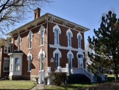 | Elbert-Bates House | building | 1985 | 85001379 |
 | Dr. George A. Jenkins House | building | 1987 | 87000027 |
 | Monroe County Courthouse | building | 1981 | 81000258 |
 | Noble-Kendall House | building | 1984 | 84001289 |
 | T. B. Perry House | building | 1983 | 83000393 |
| Saint Patrick's Roman Catholic Church | building | 1992 | 92000426 | |
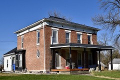 | Arvine and Elizabeth W. White House | building | 1994 | 94001100 |
Every wildfire the federal occurrence database records inside this county: 8 of them, burning about 633 acres. None started naturally and 1 was recorded as arson. Each settlement page carries the fires within five miles of it.
| Reported cause | Fires |
|---|---|
| Missing data/not specified/undetermined | 5 |
| Debris and open burning | 2 |
| Arson/incendiarism | 1 |
The five largest, by the area the report gives. One of them was set deliberately.
| Date | Cause | Size | Reported by | Name on the report |
|---|---|---|---|---|
| 9 April 2014 | Missing data/not specified/undetermined | 500 acres | Iowa Department of Natural Resources | not named |
| 11 April 2014 | Missing data/not specified/undetermined | 100 acres | Iowa Department of Natural Resources | not named |
| 21 March 2014 | Debris and open burning | 20 acres | Iowa Department of Natural Resources | not named |
| 5 April 2014 | Debris and open burning | 5.0 acres | Iowa Department of Natural Resources | not named |
| 15 March 2006 | Missing data/not specified/undetermined | 5.0 acres | Iowa Department of Natural Resources | not named |
| 18 February 2017 | Arson/incendiarism | 2.0 acres | Iowa Department of Natural Resources | not named |
| 27 February 2006 | Missing data/not specified/undetermined | 1.0 acres | Iowa Department of Natural Resources | not named |
| 14 April 2009 | Missing data/not specified/undetermined | under an acre | Iowa Department of Natural Resources | not named |
Every settlement page carries the fires within five miles of it - see the settlement index below.
The NOAA Storm Events Database holds 229 reports for this county, causing no deaths, 8 injuries and about $31,990,500 in recorded property damage. Each settlement page carries the reports that name it.
| Kind of event | Reports |
|---|---|
| Thunderstorm Wind | 73 |
| Hail | 61 |
| Flash Flood | 34 |
| Heavy Rain | 31 |
| Tornado | 14 |
| Flood | 12 |
| Funnel Cloud | 4 |
The most serious of them, by death, then injury, then recorded damage. The accounts are quoted exactly as the forecast office filed them.
| When | Event | Place named | Harm | What the report says |
|---|---|---|---|---|
| November 1988 | Tornado (F2) | not stated | 4 hurt, $250,000 | no account filed |
| May 1996 | Tornado (F1) | Avery | 2 hurt, $380,000 | no account filed |
| October 1984 | Tornado (F1) | not stated | 2 hurt, $250,000 | no account filed |
| June 1984 | Tornado (F4) | not stated | $25,000,000 | no account filed |
| June 2015 | Flood | Iconium | $1,030,000 | Many primary and secondary roads were flooded. Some roads were washed out. |
| May 2013 | Flash Flood | Melrose | $500,000 | Monroe County law enforcement reports that downtown Melrose and most of the streets in town were under water with water flowing into some buildings, including the community center with water surrounding several trailer homes. Most streets were impassible. |
| May 2013 | Flood | Melrose | $250,000 | Trained spotter reports that all streets in Melrose are now under water. Some spots are standing and some flowing. Water depth 6 to 8 inches. |
| April 2007 | Flood | Albia | $250,000 | no account filed |
| June 1964 | Tornado (F1) | not stated | $250,000 | no account filed |
| May 2013 | Flash Flood | Avery | $200,000 | Public reported about 10 inches of rain along highway 137 with flash flooding a few miles southwest of Eddyville. |
| June 2000 | Flash Flood | Countywide | $200,000 | no account filed |
| June 2015 | Tornado (EF3) | Weller | $150,000 | This powerful tornado entered from Lucas County. The tornado reached its peak intensity of EF-3 in NW Monroe County, where a house was completely swept off its foundation. Extensive tree damage was also noted in this area. |
| November 2015 | Tornado (EF2) | Melrose | $150,000 | Tornado moved from Appanoose into Monroe county. This was the strongest tornado of the day and produced extensive damage to several farmsteads. |
| May 2013 | Flash Flood | Lovilia | $150,000 | Monroe County law enforcement reports that several streets in and around Lovilia remain closed due to water over roads. The intersections of 110th, 115th and 130th are closed due to water over the road. |
| May 2013 | Flash Flood | Lovilia | $150,000 | Gravel beginning to wash away a portion of east 19th/115th Trail and a significant amount of standing water west of 14th and south of Lovilia. |
| May 2001 | Flash Flood | Countywide | $150,000 | no account filed |
| June 2015 | Tornado (EF2) | Albia | $125,000 | This tornado developed and intensified quickly just to the west of Albia where EF-2 damage occurred. The tornado dissipated as it swept into the SW corner of Albia, damaging several homes and businesses. |
| May 2019 | Flash Flood | Weller | $100,000 | Emergency manager reported that several secondary roads in Monroe and Davis Counties have water over them and will be barricaded and closed. Debris in streams also a concern for damaging culverts. |
| May 2019 | Flood | Melrose | $100,000 | Emergency manager reported multiple secondary roads remained under water or closed in Monroe County from the heavy rainfall yesterday and subsequent overland and river flooding. |
| September 2014 | Flood | Weller | $100,000 | Numerous roads remain underwater across the county. |
| May 2013 | Flash Flood | Weller | $100,000 | Water over the road from a creek out of its banks on 120th St west of Lovilia. Water was 3 feet deep and moving swiftly across the road. |
| June 2010 | Flash Flood | Albia | $100,000 | Major street flooding in Albia as Highway 5 was impassable due to water running under the railroad overpass in the northern part of town. |
| June 2010 | Flash Flood | Albia | $100,000 | Numerous gravel roads were covered with water and washed out across the southern two thirds of Monroe County. Rainfall since 0700 CST was 2.98 inches. |
| July 2008 | Thunderstorm Wind | Albia | $100,000 | A Burlington Northern train had 21 cars blown off the tracks. |
| June 2000 | Flash Flood | Albia | $100,000 | no account filed |
| May 1998 | Hail | Hiteman | $100,000 | no account filed |
| June 2011 | Thunderstorm Wind | Albia | $75,000 | Numerous small branches and limbs down along with a few portions of larger trees with some of the trees blocking portions of the road. Another tree fell onto a vehicle at the Chinese restaurant on east Benton. |
| April 2008 | Thunderstorm Wind | Avery | $75,000 | A Morton building was severely damaged. Some shingles were blown off of a house and a small grain bin was destroyed. |
| June 2008 | Hail | Albia | $75,000 | Several reports of golf ball size hail in the Albia area. Car windows were also reported to be broken. |
| June 2015 | Thunderstorm Wind | Albia | $50,000 | Public reported power out, roof damage, and trees down at Indian Hills Inn. |
| September 2014 | Flash Flood | Albia | $50,000 | Water over the road on old Highway 34 and 189th St. with a portion of the road closed. |
| April 2014 | Thunderstorm Wind | Lovilia | $50,000 | Roofs torn off of houses and trees snapped off. |
| July 2008 | Flash Flood | Selection | $50,000 | Gravel road 637th trail was damaged, rutted, and partially washed out by heavy rain. Overnight total was 4.25 inches. |
| November 2005 | Tornado (F1) | Albia | $50,000 | Tornado touched down southeast of Albia and tracked across mostly open country. |
| April 2003 | Hail | Avery | $50,000 | no account filed |
| April 2003 | Hail | Albia | $50,000 | no account filed |
| June 1998 | Flood | Albia | $50,000 | no account filed |
| February 2000 | Thunderstorm Wind | Lovilia | $40,000 | no account filed |
| July 2008 | Thunderstorm Wind | Hocking | $35,000 | Damage to shingles and tree damage. |
| July 2008 | Flash Flood | Melrose | $30,000 | Substantial street flooding was reported. |
| October 2001 | Hail | Albia | $30,000 | no account filed |
| April 2015 | Thunderstorm Wind | Albia | $25,000 | A large tree was downed at the intersection of Highway 137 and Highway 5 on the north side of Albia. Scattered tree damage was reported throughout the Albia area. |
| November 2015 | Thunderstorm Wind | Avery | $25,000 | Emergency Manager reported power poles and lines downed. |
| June 2014 | Thunderstorm Wind | Hiteman | $25,000 | The Monroe County sheriff reported traffic sign damage and a metal shed roof removed with the shed leaning near 145th Trail and Highway 5. |
| April 2013 | Flash Flood | Avery | $25,000 | Water from creek covering several miles of old Highway 34. |
| August 2011 | Thunderstorm Wind | Albia | $25,000 | Post event survey indicated numerous large tree limbs were down, portions of whole trees, and even a few large trees taken down along with power lines. |
| June 2010 | Flash Flood | Avery | $25,000 | Old Highway 34 was closed to to flash flooding between Albia and Road T61. |
| June 2010 | Flood | Avery | $25,000 | Old Highway 34 closed between Albia and Road T61. |
| July 2008 | Flash Flood | Avery | $25,000 | Water from nearby creek was covering old Highway 34. |
| June 2008 | Flash Flood | Albia Muni Arpt | $25,000 | Water was over the road at 189th and 625th Ave. Several County roads were under water across the western portion of the county. A stalled vehicle had to be pushed out of the water. |
| June 2008 | Flash Flood | Avery | $25,000 | Roads were closed due to water running over old Highway 34 east of Albia. |
| July 2008 | Flood | Melrose | $25,000 | Roads closed due to flooding in the town of Melrose. |
| July 2008 | Flash Flood | Albia | $25,000 | Flash flooding was reported at the intersection of Highway 5 and Highway 137. |
| April 2012 | Hail | Avery | $25,000 | no account filed |
| June 2008 | Hail | Avery | $25,000 | no account filed |
| June 1997 | Thunderstorm Wind | Avery | $25,000 | no account filed |
| May 1986 | Tornado (F0) | not stated | $25,000 | no account filed |
| June 2015 | Flash Flood | Melrose | $20,000 | Law Enforcement reported street and roadway flooding in the Melrose area. |
| June 2015 | Thunderstorm Wind | Lovilia | $20,000 | Public reported large tree snapped and fell on pickup truck. Report via social media. |
| June 2015 | Thunderstorm Wind | Albia | $20,000 | Storm chaser reported large tree limbs down and a large tin roof on the ground near a camping areas on the south side of Albia. |
The Survey's mineral resources record lists 4 workings inside this county. 2 still produce and 2 are closed or unrecorded. Each settlement page carries the workings within five miles of it.
| Commodity | Workings |
|---|---|
| Zinc | 1 |
| Sand and Gravel, Construction | 1 |
| Stone, Crushed/Broken | 1 |
| Bituminous | 1 |
| Sulfur-Pyrite | 1 |
The least common of them first, because a county's hundredth gravel pit says nothing its first ten did not.
| Where | Site | Commodity | Status | Recorded |
|---|---|---|---|---|
| Eddyville Quarry | Stone, Crushed/Broken | Producer | ||
| Moravia Pit | Sand and Gravel, Construction | Past Producer | ||
| Occurrence | Zinc | Past Producer | Sphalerite | |
| Star Coal Co. Coal Prep. Plant | Bituminous, Sulfur-Pyrite | Plant |
Named settlements recorded in the Geographic Names Information System, each with the topographic sheets covering it. Villages, hamlets and abandoned places alike. Each is shown with the nearest named watercourse or landform and the survey quadrangle it falls on.
Bluff Creek township · 50150 · On Gardner Creek · Buxton quadrangle
10 sheets, 1929 to 1982
Union township · 52531 · On Whippoorwill Creek · Hiteman quadrangle
10 sheets, 1929 to 1982
Guilford township · 52531 · On Coal Creek · Albia quadrangle
10 sheets, 1929 to 1982
No longer a settlement
The vanished settlements of Monroe County: the places named above that are no longer on the map.