 Block
From the record
9 National Register listings published here, 1 of them a National Historic Landmark.
Sources: the National Register database, National Park Service
29 topographic sheets cover 20 settlements here, and 9 properties are on the National Register of Historic Places.
9 National Register listings published here, 1 of them a National Historic Landmark.
Sources: the National Register database, National Park Service
Every property in this county listed on the National Register of Historic Places, with the year it was listed and the federal nomination document.
| Photograph | Property | Type | Listed | Reference |
|---|---|---|---|---|
 | Clarinda Carnegie Library | building | 2014 | 13001078 |
 | Goldenrod Schoolhouse | building | 1994 | 75000697 |
 | Col. William Peters Hepburn House | building | 1973 | 73000736 |
 | Iowan's Hotel | building | 2009 | 08001382 |
| McCoy Polygonal Barn | building | 1986 | 86001469 | |
 | Page County Courthouse | building | 1981 | 81000262 |
 | Wabash Combination Depot-Shenandoah | building | 1990 | 90001298 |
 | W. T. S. White House and Carriage House | building | 1994 | 93001544 |
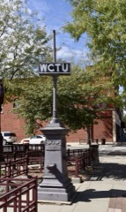 | Women's Christian Temperance Union Public Fountain | object | 1984 | 84001293 |
Every wildfire the federal occurrence database records inside this county: 21 of them, burning about 439 acres. None started naturally and none was recorded as arson. Each settlement page carries the fires within five miles of it.
| Reported cause | Fires |
|---|---|
| Missing data/not specified/undetermined | 16 |
| Equipment and vehicle use | 3 |
| Debris and open burning | 2 |
The five largest, by the area the report gives. None of them was recorded as arson.
| Date | Cause | Size | Reported by | Name on the report |
|---|---|---|---|---|
| 2 March 2018 | Debris and open burning | 260 acres | Iowa Department of Natural Resources | not named |
| 13 March 2018 | Debris and open burning | 100 acres | Iowa Department of Natural Resources | not named |
| 7 October 2020 | Equipment and vehicle use | 30 acres | Iowa Department of Natural Resources | not named |
| 15 April 2010 | Missing data/not specified/undetermined | 15 acres | Iowa Department of Natural Resources | 24656 SANDHILL TRAIL, SECTION #17, GRANT TOWNSHIP, |
| 16 March 2011 | Missing data/not specified/undetermined | 7.0 acres | Iowa Department of Natural Resources | S. OF 137TH ST. JUST W. OF HEPBURN, IA |
| 8 October 2020 | Equipment and vehicle use | 5.0 acres | Iowa Department of Natural Resources | not named |
| 4 March 2006 | Missing data/not specified/undetermined | 4.0 acres | Iowa Department of Natural Resources | not named |
| 1 April 2011 | Missing data/not specified/undetermined | 3.0 acres | Iowa Department of Natural Resources | 1171 WILLOW AVE, IA |
Every settlement page carries the fires within five miles of it - see the settlement index below.
The NOAA Storm Events Database holds 349 reports for this county, causing 2 deaths, 53 injuries and about $15,601,000 in recorded property damage. Each settlement page carries the reports that name it.
| Kind of event | Reports |
|---|---|
| Thunderstorm Wind | 142 |
| Hail | 135 |
| Tornado | 41 |
| Flood | 15 |
| Flash Flood | 5 |
| Funnel Cloud | 5 |
| Heavy Rain | 5 |
| Lightning | 1 |
The most serious of them, by death, then injury, then recorded damage. The accounts are quoted exactly as the forecast office filed them.
| When | Event | Place named | Harm | What the report says |
|---|---|---|---|---|
| April 1964 | Tornado (F4) | not stated | 1 killed, 28 hurt, $2,500,000 | no account filed |
| August 2025 | Thunderstorm Wind | Shenandoah | 1 killed | A damaging wind event swept through Page County, Iowa, during the morning of August 10th, 2025. The most severe damage occurred near Shenandoah, where straight-line wind gusts were estimated as high as 95 miles per hour. Tragically, 1 mile north-northwest of Shenandoah, Emergency Management reported an incident that resulted in 1 fatality when a shed at a campsite was overturned, along with significant tree damage and minor structural damage in the area. Further reports of estimated 95 miles per hour gusts in the same vicinity detailed numerous large snapped trees. In addition, an estimated 70 miles per hour gust 1 mile west of Shenandoah was responsible for overturning a semi-truck in a retail parking lot. The storm left a path of destruction across the county, particularly around Shenandoah. |
| March 1979 | Tornado (F4) | not stated | 16 hurt, $2,500,000 | no account filed |
| June 1984 | Tornado (F3) | not stated | 3 hurt, $2,500,000 | no account filed |
| June 1964 | Tornado (F3) | not stated | 2 hurt, $2,500,000 | no account filed |
| April 1954 | Tornado (F4) | not stated | 2 hurt, $25,000 | no account filed |
| June 1964 | Tornado (F3) | not stated | 1 hurt, $250,000 | no account filed |
| April 1999 | Tornado (F1) | College Spgs | 1 hurt, $100,000 | Of the 12 tornadoes reported over eastern Nebraska and southwest Iowa on 4/8/99, this one produced the only injury, to a woman who suffered minor cuts due to flying glass. The tornado touched down just southwest of College Springs, tracked west of that town and then lifted just southwest of Clarinda. Several houses sustained strong f1 damage including one workshop that was destroyed. Much of the damage was due to flying corrugated steel and wood debris with roofs sustaining the most damage. |
| May 2007 | Flood | Shenandoah | $932,000 | Heavy rainfall over the weekend of May 4th through the 6th, caused the the East Nishnabotna River to flood around the Shenandoah area. Flood waters inundated 45 trailers and some vehicles near town and caused the closure of Highways 59, 48 and old Highway 2. Most if not all main east to west county roads across the county were closed due to flood waters. See Montgomery county for river levels of the East Nishnabotna River at Red Oak.|Flooding along the East Nishnabotna River, the Nodaway River and other smaller streams caused almost 1 million dollars worth of damage to county roads and bridges. |
| May 2007 | Flood | Clarinda | $932,000 | Heavy rainfall over the weekend of May 4th through the 6th, caused the Nodaway River to briefly surpass it's 19 foot flood stage near Clarinda during the mid afternoon hours on May 6th. The river crested around 19.2 feet at 345 pm on the 6th. After falling a little below flood stage an hour later, the Nodaway River remained high for an additional 24 to 36 hours. Flood damage from the Nodaway River, the East Nishnabotna River and other small tributaries amounted to almost 1 million dollars. |
| June 2008 | Flood | Essex | $800,000 | Rainfall of 3 to 5 inches fell over much of southwest Iowa during the late afternoon and overnight hours of June 4th and 5th. The heavy rain caused the East Nishnabotna River to flood northwest Page county. The river at Red Oak, which is just upstream in Montgomery county, crested at 21.9 feet around 845 am CDT on June 5th. Flood stage is 18 feet. The river at Red Oak was above flood stage from around 115 am until 430 pm on June 5th. The flooding in Page county damaged crop land and levees along the river, flooded a park and some basements in Shenandoah and took out a county road and bridge. The flooding also prompted the evacuation of a mobile home park in Shenandoah. |
| June 2008 | Flood | Clarinda | $550,000 | Rainfall of 3 to 5 inches during the late afternoon and overnight hours of June 4th and 5th caused the Nodaway River to flood in Page county. The river at Clarinda crested at 26.6 feet at 1015 pm CDT on June 5th, flood stage is 19.0 feet. The river at Clarinda was above flood stage from around 245 am on the 5th until 930 pm on June 6th. The flooding caused the closure of Highway 71 near the Missouri border and several county roads. One bridge sustained major damage as did several of the county roads that were flooded. At least several hundred acres of agricultural land were also flooded. Clarinda lost part of its waste water treatment plant due to flood waters and Braddyville lost its lagoon system and also sustained damage to its wells. |
| April 1998 | Thunderstorm Wind | Braddyville | $400,000 | Several barns and outbuildings in rural areas near Braddyville were damaged or destroyed. |
| May 1987 | Tornado (F1) | not stated | $250,000 | no account filed |
| May 1983 | Tornado (F1) | not stated | $250,000 | no account filed |
| May 1983 | Tornado (F1) | not stated | $250,000 | no account filed |
| June 1967 | Tornado (F1) | not stated | $250,000 | no account filed |
| September 1964 | Tornado (F2) | not stated | $250,000 | no account filed |
| May 1996 | Lightning | Clarinda | $35,000 | no account filed |
| April 2001 | Thunderstorm Wind | Shenandoah | $30,000 | Thunderstorm winds estimated at 60 to 80 mph peeled the roof off the new country club in town. |
| July 1987 | Tornado (F1) | not stated | $25,000 | no account filed |
| September 1979 | Tornado (F1) | not stated | $25,000 | no account filed |
| June 1975 | Tornado (F2) | not stated | $25,000 | no account filed |
| May 1971 | Tornado (F1) | not stated | $25,000 | no account filed |
| November 1960 | Tornado (F1) | not stated | $25,000 | no account filed |
| April 1955 | Tornado (F2) | not stated | $25,000 | no account filed |
| April 1999 | Tornado (F1) | Clarinda | $20,000 | This tornado dissipated around the same time a longer tracked tornado formed near the Adams and Taylor county lines in southwest Iowa. In Page county the damage was relatively minor, however, much stronger damage was reported farther to the northeast. |
| April 1998 | Thunderstorm Wind | College Spgs | $20,000 | Tree blown down onto a trailer. |
| July 2015 | Flash Flood | Clarinda | $15,000 | Local law enforcement reported extensive street flooding in the city of Clarinda. Up to two feet of water was reported in some streets. |
| June 2000 | Thunderstorm Wind | Braddyville | $15,000 | Thunderstorm winds blew a barn down near Braddyville. |
| July 2015 | Flash Flood | Shenandoah | $10,000 | Extensive street flooding was reported in Shenadoah, including water flowing across State Highway 48. |
| April 1999 | Tornado (F1) | Shenandoah | $10,000 | Tornado touched down just northeast of Shenandoah causing minimal damage. |
| April 1998 | Thunderstorm Wind | Blanchard | $10,000 | Damage to a grain bin |
| June 2011 | Flood | Shambaugh | $6,000 | Rainfall of 1 to 3 inches in less than a 12 hour time period brought lowland flooding along the Nodaway River in southwest Iowa. The river near Clarinda crested around 22 feet in the morning of 6/27, flood stage is 19 feet. The river flooded a few county roads and adjacent farm land. |
| September 2014 | Flood | Clarinda | $5,000 | A slow moving thunderstorm complex lead to heavy rainfall on the 9th causing the Nodaway River to rise above flood stage around the Clarinda area. The river rose above flood stage during the early morning on the 10th, crested later that morning, and fell below flood stage during the evening. The flooding was minor and confined to low-lying areas. |
| August 2014 | Flood | Clarinda | $5,000 | Repeated thunderstorms on the 27th and 28th of August caused heavy rainfall and the Nodaway River to go into flood. The river rose above flood stage on the evening of the 28th, the river created during the afternoon of the 29th, and fell below flood stage in the early morning of the 30th. The flooding was generally minor and confined to low-lying areas along the river. |
| June 2014 | Flood | Hepburn | $5,000 | Heavy rain caused the Nodaway River to flood near the Clarinda area. The river at Clarinda reached a crest a little over 24.5 feet early in the morning of June 4, flood stage is 23 feet. The flooding impacted a few county roads and farmland along the river. |
| August 1993 | Hail | Bethesda | $5,000 | Thunderstorms rolled across the southwest corner of Iowa during the early morning hours. Hail fell at a few locations, causing some damage to crops and property. |
| April 1994 | Thunderstorm Wind | Northboro | $5,000 | no account filed |
| June 1994 | Hail | Bethesda | $5,000 | no account filed |
| May 1983 | Tornado (F0) | not stated | $2,500 | no account filed |
| August 1979 | Tornado (F3) | not stated | $2,500 | no account filed |
| April 1955 | Tornado (F1) | not stated | $2,500 | no account filed |
| April 1999 | Thunderstorm Wind | College Spgs | $2,000 | Windows blown out of a house. |
| July 2018 | Thunderstorm Wind | Shenandoah | $1,000 | KMA radio station in Shenandoah reported a 54 mph wind gust and a downed power line. |
| May 1983 | Tornado (F0) | not stated | $250 | no account filed |
| May 1971 | Tornado (F0) | not stated | $250 | no account filed |
| April 2026 | Hail | Essex | - | Emergency management report of hail measured up to 1 inch in diameter in Essex, IA. |
| April 2026 | Tornado (EF0) | Coin | - | Two spotter reports confirmed a funnel with rotating dust at ground level with minor tree damage at one location. The track was mainly over open fields. Maximum wind speeds were estimated at 70 mph. |
| April 2026 | Thunderstorm Wind | Bethesda | - | Personal weather station measured wind gust of 58 mph. |
| June 2025 | Thunderstorm Wind | Essex Arpt | - | Delayed report from emergency management of trees across road and power lines down. Time estimated from radar. |
| June 2025 | Thunderstorm Wind | Nyman | - | Personal weather station measured wind gust of 72 mph. The wind damage occurred on the north side of a small thunderstorm complex moving through the area, where evaporative cooling of anvil precipitation likely bolstered downdraft strength. |
| April 2025 | Tornado (EF1) | Essex Arpt | - | This is a continuation of the Fremont County segment of this EF-1 tornado. The tornado tracked just north of Essex, IA, with more wooden power poles snapped and farm outdoor building damage. After sliding north of Essex, IA, the tornado tracked northeast towards Nyman, IA. Similar damage, including trees, outdoor buildings, and wooden power poles were observed along this stretch. The tornado lifted just east at Nyman, IA at approximately 8:08 PM CST. The maximum wind speed during this segment of the track was estimated at 110 mph, classifying it as an EF1. The tornado had a maximum width of 1219 yards, 0 fatalities and 0 injuries. |
| April 2025 | Hail | Essex Arpt | - | Emergency management report of hail estimated up to 2.75 in diameter. |
| April 2025 | Thunderstorm Wind | Nyman | - | Personal weather station measured wind gust of 86 mph. Radar indicates the measurement was likely in the RFD. |
| April 2025 | Thunderstorm Wind | Nyman | - | Personal weather station measured wind gust of 74 mph. Radar indicates the measurement was likely in the RFD. |
| July 2025 | Tornado (EFU) | Hawleyville | - | Emergency management reported a brief, weak tornado in Page County, Iowa, at 3:46 PM. The time of the tornado was confirmed through video evidence and radar data. The tornado did not cause any damage, which resulted in an EFU rating. |
| April 2024 | Hail | Clarinda | - | A CO-OP observer reported quarter sized hail on the southeast side of Clarinda. |
| May 2024 | Hail | Clarinda Muni Arpt | - | A swath of golfball size hail fell across portions of east-central and northeastern Page County. The office first received a photo relayed via emergency management of golfball sized hail in Clarinda. It was also reported that the golfball sized hail lasted around 5 minutes resulting in damage to cars. The hailstorm continued to the north-northeast where there was another public report of golfball sized hail in Hepburn. |
| May 2024 | Thunderstorm Wind | Clarinda | - | The office received a delayed report from the public of tree damage in Clarinda. A maple tree 18 inches in diameter was snapped. |
The Survey's mineral resources record lists 9 workings inside this county. 3 still produce and 6 are closed or unrecorded. Each settlement page carries the workings within five miles of it.
| Commodity | Workings |
|---|---|
| Sand and Gravel, Construction | 7 |
| Stone, Crushed/Broken | 2 |
The least common of them first, because a county's hundredth gravel pit says nothing its first ten did not.
| Where | Site | Commodity | Status | Recorded |
|---|---|---|---|---|
| Barlow Quarry | Stone, Crushed/Broken | Past Producer | ||
| Maxwell Quarry | Stone, Crushed/Broken | Producer | ||
| Essex Pit | Sand and Gravel, Construction | Past Producer | ||
| Shenandoah Plant | Sand and Gravel, Construction | Producer | ||
| Stanley Sand and Gravel Pit | Sand and Gravel, Construction | Producer | ||
| Unknown | Sand and Gravel, Construction | Past Producer | ||
| Unknown | Sand and Gravel, Construction | Past Producer | ||
| Unknown | Sand and Gravel, Construction | Past Producer | ||
| Unknown | Sand and Gravel, Construction | Past Producer |
Named settlements recorded in the Geographic Names Information System, each with the topographic sheets covering it. Villages, hamlets and abandoned places alike. Each is shown with the nearest named watercourse or landform and the survey quadrangle it falls on.
Nodaway township · 51632 · On North Branch West Nodaway River · Clarinda South quadrangle
12 sheets, 1940 to 1993
Amity township · 51637 · On Middle Mill Creek · Clearmont quadrangle
12 sheets, 1940 to 1993
Pierce township · 51638 · On Eightmile Branch · Shenandoah East quadrangle
8 sheets, 1955 to 1993
Harlan township · 51632 · On No Business Creek · Clarinda South quadrangle
12 sheets, 1940 to 1993
Grant township · 51601 · On Fourmile Creek · Shenandoah East quadrangle
8 sheets, 1955 to 1993
Tarkio township · 51632 · On Snake Creek · Coin quadrangle
12 sheets, 1940 to 1993
No longer a settlement
Colfax township · 51630 · On Long Branch · Westboro quadrangle
10 sheets, 1939 to 1993
No longer a settlement
The vanished settlements of Page County: the places named above that are no longer on the map.