 Block
From the record
4 National Register listings published here.
Sources: the National Register database, National Park Service
23 topographic sheets cover 13 settlements here, and 4 properties are on the National Register of Historic Places.
4 National Register listings published here.
Sources: the National Register database, National Park Service
Every property in this county listed on the National Register of Historic Places, with the year it was listed and the federal nomination document.
| Photograph | Property | Type | Listed | Reference |
|---|---|---|---|---|
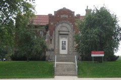 | Emmetsburg Public Library | building | 1983 | 83000397 |
| First Presbyterian Church | building | 2010 | 10000276 | |
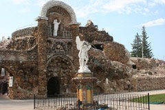 | Grotto of the Redemption | structure | 2001 | 00001679 |
| Ormsby-Kelly House | building | 1977 | 77000545 |
Every wildfire the federal occurrence database records inside this county: 12 of them, burning about 565 acres. 1 started naturally and none was recorded as arson. Each settlement page carries the fires within five miles of it.
| Reported cause | Fires |
|---|---|
| Missing data/not specified/undetermined | 9 |
| Smoking | 1 |
| Debris and open burning | 1 |
| Natural | 1 |
The five largest, by the area the report gives. None of them was recorded as arson.
| Date | Cause | Size | Reported by | Name on the report |
|---|---|---|---|---|
| 14 April 2009 | Missing data/not specified/undetermined | 401 acres | Iowa Department of Natural Resources | not named |
| 5 April 2015 | Debris and open burning | 50 acres | Iowa Department of Natural Resources | not named |
| 7 May 2018 | Missing data/not specified/undetermined | 45 acres | Iowa Department of Natural Resources | not named |
| 4 May 2019 | Missing data/not specified/undetermined | 40 acres | Iowa Wetland Management District | BLUE WING MARSH |
| 29 May 2014 | Smoking | 21 acres | Iowa Department of Natural Resources | not named |
| 22 May 2006 | Missing data/not specified/undetermined | 3.0 acres | Iowa Department of Natural Resources | not named |
| 7 April 2011 | Missing data/not specified/undetermined | 2.0 acres | Iowa Department of Natural Resources | 580TH & 280TH, IA |
| 7 May 2011 | Missing data/not specified/undetermined | 1.0 acres | Iowa Department of Natural Resources | NE CORNER OF 12 MILE LAKE, IA |
Every settlement page carries the fires within five miles of it - see the settlement index below.
The NOAA Storm Events Database holds 345 reports for this county, causing 1 death, 1 injury and about $11,542,760 in recorded property damage. Each settlement page carries the reports that name it.
| Kind of event | Reports |
|---|---|
| Hail | 125 |
| Thunderstorm Wind | 102 |
| Heavy Rain | 39 |
| Flood | 28 |
| Tornado | 22 |
| Flash Flood | 19 |
| Funnel Cloud | 6 |
| Lightning | 4 |
The most serious of them, by death, then injury, then recorded damage. The accounts are quoted exactly as the forecast office filed them.
| When | Event | Place named | Harm | What the report says |
|---|---|---|---|---|
| June 2008 | Lightning | Curlew | 1 killed | no account filed |
| June 1984 | Tornado (F2) | not stated | 1 hurt, $2,500,000 | no account filed |
| July 1980 | Tornado (F2) | not stated | $2,500,000 | no account filed |
| June 2024 | Flood | Emmetsburg Arpt | $721,000 | The West Fork of the Des Moines at Emmetsburg crested at 15.47 ft on June 24 at 01:15 pm CDT. The river remained in flood through the end of the month and into July. Preliminary information indicates this is the new flood of record for the point. |
| December 2021 | Thunderstorm Wind | Ruthven | $500,000 | Law enforcement reported hog building completely destroyed. |
| June 1994 | Thunderstorm Wind | Mallard | $500,000 | no account filed |
| June 1994 | Tornado (F2) | not stated | $500,000 | no account filed |
| July 1997 | Lightning | Graettinger | $250,000 | no account filed |
| April 1967 | Tornado (F2) | not stated | $250,000 | no account filed |
| June 1967 | Tornado (F0) | not stated | $250,000 | no account filed |
| July 1997 | Tornado (F1) | Emmetsburg Arpt | $220,000 | no account filed |
| July 1997 | Flash Flood | Emmetsburg | $150,000 | no account filed |
| May 2019 | Flood | Emmetsburg Arpt | $100,000 | The West Fork of the Des Moines River at Emmetsburg crested at 12.44 feet on 31 May 2019 at 23:45 UTC. |
| June 2018 | Flood | Emmetsburg Arpt | $100,000 | The West Fork of the Des Moines River at Emmetsburg crested twice through the period of flooding. The river remained in flood into July. The first crest was at 12.55 feet on 24 June 2018 at 01:45 UTC, and the second one was at 13.00 feet on 27 June 2018 at 09:00 UTC. |
| July 2018 | Flood | Emmetsburg Arpt | $100,000 | The West Fork of the Des Moines River at Emmetsburg went into flood in late June and remained in flood through much of July. The river crested 3 times in July. The first crest at 13.25 feet on 3 July 2018 at 13:45Z, the second crest at 13.02 feet on 4 July 2018 at 18:00 UTC, and the third crest at 13.26 feet on 11 July 2018 at 03:00 UTC. |
| September 2018 | Flood | Emmetsburg Arpt | $100,000 | The West Fork of the Des Moines River at Emmetsburg crested at 11.29 feet on 23 September 2018 at 0530 UTC. |
| July 1997 | Flash Flood | Graettinger | $100,000 | no account filed |
| August 2007 | Flash Flood | Emmetsburg Arpt | $75,000 | Two feet of water was reported over highway 18 in Emmetsburg, at main and Lawler. The water receded around 0900CST. Several county roads from Emmetsburg to Graettinger had minor evidence of water running over roads. |
| December 2021 | Tornado (EF1) | Ayrshire | $60,000 | Path of damage began a couple miles northeast of Ayrshire and moved north northeast, dissipating to the southeast of Graettinger. Along the path, several trees were damage along with a roof off of an outbuilding along with power pole damage. |
| June 1998 | Flash Flood | Emmetsburg | $60,000 | no account filed |
| August 1995 | Thunderstorm Wind | Graettinger | $60,000 | no account filed |
| July 2025 | Thunderstorm Wind | Ruthven | $50,000 | Personal weather station gust to 62 mph. Widespread tree damage and minor sheet metal damage through the town of Ruthven just south of this station. |
| August 2018 | Hail | Ayrshire | $50,000 | Public reported up to around baseball or larger sized hail. Time estimated from radar. |
| August 2018 | Hail | West Bend | $50,000 | Emergency manager reported windows broken on houses and cars by hail. This is a delayed report and time estimated from radar. |
| June 2018 | Flood | Emmetsburg | $50,000 | Water was flooding portions of US Hwy 18 east of Emmetsburg and in Cylinder. Water was also over Hwy 18 at the 4900 block of 370th St. and the 5500 block of 390th Street. |
| June 2014 | Flash Flood | Osgood | $50,000 | Water over 450th Avenue near the 3100 block. |
| July 2011 | Flash Flood | Graettinger | $50,000 | Considerable water flowing over the highway. The water was over a foot deep. |
| August 2011 | Thunderstorm Wind | Emmetsburg | $50,000 | Numerous trees uprooted in town. Some minor flooding was also noted. |
| March 2011 | Flood | Graettinger | $50,000 | no account filed |
| March 2010 | Flood | Graettinger | $50,000 | no account filed |
| April 2010 | Flood | Graettinger | $50,000 | no account filed |
| March 2007 | Flood | Emmetsburg | $50,000 | no account filed |
| September 2004 | Flash Flood | Countywide | $50,000 | no account filed |
| October 2002 | Hail | Emmetsburg | $50,000 | no account filed |
| June 2000 | Thunderstorm Wind | Depew | $50,000 | no account filed |
| July 2000 | Flash Flood | Countywide | $50,000 | no account filed |
| July 2000 | Thunderstorm Wind | Ruthven | $50,000 | no account filed |
| August 1998 | Hail | West Bend | $50,000 | no account filed |
| June 1994 | Thunderstorm Wind | Mallard | $50,000 | no account filed |
| June 1994 | Thunderstorm Wind | Mallard | $50,000 | no account filed |
| July 1994 | Tornado (F1) | Cylinder | $50,000 | no account filed |
| April 2009 | Lightning | Graettinger | $45,000 | no account filed |
| August 1995 | Thunderstorm Wind | Emmetsburg | $45,000 | no account filed |
| October 2000 | Thunderstorm Wind | Mallard | $40,000 | no account filed |
| June 1995 | Thunderstorm Wind | Emmetsburg | $35,000 | no account filed |
| October 2000 | Tornado (F1) | West Bend | $30,000 | Numerous trees toppled as this tornado moved in from Pocahontas County and lifted southwest of West Bend. |
| May 2000 | Thunderstorm Wind | Cylinder | $30,000 | no account filed |
| December 2021 | Thunderstorm Wind | Osgood | $25,000 | Law enforcement reported damage to outbuilding and trees uprooted. Time estimated from radar. |
| June 2018 | Flash Flood | Rodman | $25,000 | County Sheriff's Office reported fully water-covered roads in and around the town of Rodman. |
| September 2014 | Thunderstorm Wind | Ruthven | $25,000 | The Palo Alto County EM reported several 24 inch diameter trees downed along with several power lines down in Ruthven. |
| June 2014 | Thunderstorm Wind | Emmetsburg | $25,000 | Trees were blown down. |
| April 2010 | Hail | Emmetsburg | $25,000 | Largest hail was on the south side of town where golf ball size hail was reported. Quarter size hail fell on the north side of town. |
| August 2010 | Thunderstorm Wind | Graettinger | $25,000 | Local law enforcement reported streets closed due to downed trees in Graettinger. |
| June 2008 | Flash Flood | Mallard | $25,000 | Water reported over Highway 4 south of Mallard. |
| April 2004 | Hail | Mallard | $25,000 | no account filed |
| September 2004 | Flash Flood | Emmetsburg | $25,000 | no account filed |
| August 1995 | Hail | Ayrshire | $25,000 | no account filed |
| August 1995 | Hail | Webb | $25,000 | no account filed |
| June 1979 | Tornado (F0) | not stated | $25,000 | no account filed |
| July 1978 | Tornado (F1) | not stated | $25,000 | no account filed |
The Survey's mineral resources record lists 41 workings inside this county. 4 still produce and 37 are closed or unrecorded. Each settlement page carries the workings within five miles of it.
| Commodity | Workings |
|---|---|
| Sand and Gravel, Construction | 41 |
The least common of them first, because a county's hundredth gravel pit says nothing its first ten did not.
| Where | Site | Commodity | Status | Recorded |
|---|---|---|---|---|
| Boggess Pit | Sand and Gravel, Construction | Producer | ||
| Dorweiller Pit | Sand and Gravel, Construction | Past Producer | ||
| Fehr | Sand and Gravel, Construction | Past Producer | ||
| Hankey Pit | Sand and Gravel, Construction | Past Producer | ||
| Hansen Pit | Sand and Gravel, Construction | Past Producer | ||
| Hoffert Sand and Gravel | Sand and Gravel, Construction | Producer | ||
| Hurd Pit | Sand and Gravel, Construction | Past Producer | ||
| Lammers Pit | Sand and Gravel, Construction | Past Producer | ||
| Palo Alto County Pits | Sand and Gravel, Construction | Producer | ||
| Ryan Pit | Sand and Gravel, Construction | Past Producer | ||
| Unknown | Sand and Gravel, Construction | Past Producer | ||
| Unknown | Sand and Gravel, Construction | Past Producer | ||
| Unknown | Sand and Gravel, Construction | Producer | ||
| Unknown | Sand and Gravel, Construction | Past Producer | ||
| Unknown | Sand and Gravel, Construction | Past Producer | ||
| Unknown | Sand and Gravel, Construction | Past Producer | ||
| Unknown | Sand and Gravel, Construction | Past Producer | ||
| Unknown | Sand and Gravel, Construction | Past Producer | ||
| Unknown | Sand and Gravel, Construction | Past Producer | ||
| Unknown | Sand and Gravel, Construction | Past Producer | ||
| Unknown | Sand and Gravel, Construction | Past Producer | ||
| Unknown | Sand and Gravel, Construction | Past Producer | ||
| Unknown | Sand and Gravel, Construction | Past Producer | ||
| Unknown | Sand and Gravel, Construction | Past Producer | ||
| Unknown | Sand and Gravel, Construction | Past Producer | ||
| Unknown | Sand and Gravel, Construction | Past Producer | ||
| Unknown | Sand and Gravel, Construction | Past Producer | ||
| Unknown | Sand and Gravel, Construction | Past Producer | ||
| Unknown | Sand and Gravel, Construction | Past Producer | ||
| Unknown | Sand and Gravel, Construction | Past Producer | ||
| Unknown | Sand and Gravel, Construction | Past Producer | ||
| Unknown | Sand and Gravel, Construction | Past Producer | ||
| Unknown | Sand and Gravel, Construction | Past Producer | ||
| Unknown | Sand and Gravel, Construction | Past Producer | ||
| Unknown | Sand and Gravel, Construction | Past Producer | ||
| Unknown | Sand and Gravel, Construction | Past Producer | ||
| Unknown | Sand and Gravel, Construction | Past Producer | ||
| Unknown | Sand and Gravel, Construction | Past Producer | ||
| Unknown | Sand and Gravel, Construction | Past Producer | ||
| Unknown | Sand and Gravel, Construction | Past Producer | ||
| West Bend Pit | Sand and Gravel, Construction | Past Producer |
Named settlements recorded in the Geographic Names Information System, each with the topographic sheets covering it. Villages, hamlets and abandoned places alike. Each is shown with the nearest named watercourse or landform and the survey quadrangle it falls on.
Lost Island township · 51342 · Graettinger West quadrangle
7 sheets, 1954 to 1985
No longer a settlement
The vanished settlements of Palo Alto County: the places named above that are no longer on the map.