 Block
From the record
3 National Register listings published here.
Sources: the National Register database, National Park Service
19 topographic sheets cover 16 settlements here, and 3 properties are on the National Register of Historic Places.
3 National Register listings published here.
Sources: the National Register database, National Park Service
Every property in this county listed on the National Register of Historic Places, with the year it was listed and the federal nomination document.
| Photograph | Property | Type | Listed | Reference |
|---|---|---|---|---|
 | Laurens Carnegie Free Library | building | 1974 | 74000804 |
 | Pocahontas County Courthouse | building | 1981 | 81000264 |
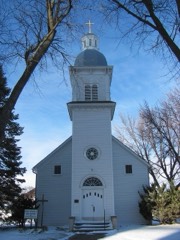 | Saints Peter and Paul Catholic Church | building | 1994 | 94000086 |
Every wildfire the federal occurrence database records inside this county: 30 of them, burning about 326 acres. None started naturally and none was recorded as arson. Each settlement page carries the fires within five miles of it.
| Reported cause | Fires |
|---|---|
| Missing data/not specified/undetermined | 28 |
| Equipment and vehicle use | 1 |
| Debris and open burning | 1 |
The five largest, by the area the report gives. None of them was recorded as arson.
| Date | Cause | Size | Reported by | Name on the report |
|---|---|---|---|---|
| 15 April 2008 | Missing data/not specified/undetermined | 60 acres | Iowa Department of Natural Resources | not named |
| 15 April 2009 | Missing data/not specified/undetermined | 60 acres | Iowa Department of Natural Resources | not named |
| 29 March 2009 | Missing data/not specified/undetermined | 60 acres | Iowa Department of Natural Resources | not named |
| 18 August 2006 | Missing data/not specified/undetermined | 21 acres | Iowa Department of Natural Resources | not named |
| 21 March 2009 | Missing data/not specified/undetermined | 20 acres | Iowa Department of Natural Resources | not named |
| 25 February 2006 | Missing data/not specified/undetermined | 20 acres | Iowa Department of Natural Resources | not named |
| 2 March 2006 | Missing data/not specified/undetermined | 20 acres | Iowa Department of Natural Resources | not named |
| 26 January 2006 | Missing data/not specified/undetermined | 20 acres | Iowa Department of Natural Resources | not named |
Every settlement page carries the fires within five miles of it - see the settlement index below.
The NOAA Storm Events Database holds 356 reports for this county, causing no deaths, 2 injuries and about $26,607,980 in recorded property damage. Each settlement page carries the reports that name it.
| Kind of event | Reports |
|---|---|
| Hail | 145 |
| Thunderstorm Wind | 93 |
| Tornado | 45 |
| Heavy Rain | 42 |
| Funnel Cloud | 16 |
| Flash Flood | 8 |
| Flood | 6 |
| Lightning | 1 |
The most serious of them, by death, then injury, then recorded damage. The accounts are quoted exactly as the forecast office filed them.
| When | Event | Place named | Harm | What the report says |
|---|---|---|---|---|
| June 1984 | Tornado (F2) | not stated | 1 hurt, $2,500,000 | no account filed |
| April 2022 | Tornado (EF2) | Palmer | 1 hurt, $150,000 | Tornado developed a few miles east northeast of Palmer and moved northeast to north for the entire path. The tornado destroyed a farm buildings and also snapped several power poles producing the EF2 rating. Otherwise, much of the path was in rural cropland with a large dust cloud enveloping the tornado for much of its life. |
| April 2011 | Tornado (EF3) | Fonda | $10,000,000 | This is a continuation of a large wedge tornado. This tornado started in Sac County, clipped southeast Buena Vista County and continued in Pocahontas County. This tornado continued to produce numerous satellite tornadoes through Pocahontas County. This produced an unusual and varying debris field. |
| April 2011 | Tornado (EF4) | Varina | $2,500,000 | An intense EF4 satellite tornado on the west flank of a large wedge tornado passing through western Pocahontas county. This tornado approached from the northwest and completely destroyed a home leaving little debris at the site. Grove of mature hardwood trees near the home was decimated and debarked and a large combine in the machine shed was tossed and rolled several hundred feet. This tornado also absorbed the circulation of an EF2 satellite tornado. |
| June 1990 | Tornado (F2) | not stated | $2,500,000 | no account filed |
| April 1984 | Tornado (F2) | not stated | $2,500,000 | no account filed |
| June 1984 | Tornado (F2) | not stated | $2,500,000 | no account filed |
| July 2010 | Tornado (EF1) | Westview | $1,000,000 | Tornado touched down 1 mile south of Pocahontas near Highway 4. It traveled 2.6 miles on the ground and lilfted northeast of the golf course and prior to the airport. Peak wind was estimated to be 100 MPH. |
| June 2013 | Thunderstorm Wind | Ware | $250,000 | Damage to several houses, including the loss of roofing and debris embedded in exterior walls. Farm equipment blown over. Damage occurred in a fairly narrow two mile long path. |
| June 2008 | Flash Flood | Laurens | $150,000 | Extensive flooding stopping travel and water was backing up into basements. |
| June 2015 | Thunderstorm Wind | Rolfe | $100,000 | Four houses with tree damage and some outbuilding damage. |
| April 2011 | Tornado (EF2) | Varina | $100,000 | A short but relatively intense tornado. This was a satellite tornado to a large wedge tornado that moved through western Pocahontas County. This tornado became absorbed into the circulation of another powerful satellite tornado that moved in from the west. |
| July 2010 | Thunderstorm Wind | Pocahontas | $100,000 | Coop building and implement machine shed had significant damage near Highway 3 and Main Street. Several large tree branches were down with whole trees downed on the northeast side of town. Tree damage was also reported at the country club in town. |
| August 2002 | Thunderstorm Wind | Pocahontas | $100,000 | no account filed |
| April 2011 | Hail | Laurens | $75,000 | The public reported baseball size hail and some minor urban flooding. |
| August 2007 | Flash Flood | Plover | $75,000 | Highway 3 was closed near Gilmore City by water running over the road. |
| July 1998 | Thunderstorm Wind | Rolfe | $75,000 | no account filed |
| August 1996 | Flood | Pocahontas | $75,000 | no account filed |
| June 2018 | Flash Flood | Pocahontas | $50,000 | Trained spotter reported Highway 4 in Pocahontas was partially covered and some side streets in town were covered in water as well. |
| June 2016 | Thunderstorm Wind | Rolfe | $50,000 | Trained spotter reported a moderately sized cattle shed was destroyed along with tree branches down around the homestead. A grain bin was also blown a half-mile into a nearby field. Another shed was badly damaged at a nearby homestead. |
| June 2013 | Thunderstorm Wind | Ware | $50,000 | Several machine sheds blown over in the Ware area by high winds. |
| October 2000 | Tornado (F1) | Havelock | $50,000 | Wagons were overturned in Pocahontas County before the tornado moved into Palo Alto County. |
| June 2007 | Thunderstorm Wind | Laurens | $50,000 | no account filed |
| August 2001 | Flash Flood | South Portion | $50,000 | no account filed |
| June 1998 | Flood | Laurens | $50,000 | no account filed |
| May 1994 | Hail | Laurens | $50,000 | no account filed |
| September 1994 | Hail | Pocahontas | $50,000 | no account filed |
| June 2013 | Thunderstorm Wind | Ware | $40,000 | Damage to machinery buildings with one blown over and two others damaged. |
| April 2013 | Thunderstorm Wind | Laurens | $40,000 | An athletic equipment shed and baseball field dugout at the Laurens-Marathon school was destroyed. At least four trees had multiple branches down. |
| June 1998 | Flash Flood | Pocahontas | $40,000 | no account filed |
| September 1998 | Hail | Palmer | $35,000 | no account filed |
| May 2014 | Thunderstorm Wind | Fonda | $30,000 | A county sheriff reported straight line winds blew the roof off of a shed. |
| August 2007 | Thunderstorm Wind | Plover | $30,000 | High winds downed power poles down and trees between Rolfe and Plover. |
| May 1998 | Thunderstorm Wind | Pocahontas | $30,000 | no account filed |
| May 1998 | Flood | Pocahontas | $30,000 | no account filed |
| May 1995 | Thunderstorm Wind | Pocahontas | $30,000 | no account filed |
| June 2014 | Thunderstorm Wind | Rolfe | $25,000 | Several 3 to 4 inch diameter tree limbs down, some over 6 inches. |
| May 2012 | Hail | Pocahontas | $25,000 | Golf ball size hail was reported on the north side of town with half dollar size hail reported at the Casey's location. |
| August 2010 | Thunderstorm Wind | Fonda | $25,000 | Walls of brick buildings destroyed on main street and a 40,000 bushel grain bin was destroyed. |
| July 2010 | Thunderstorm Wind | Havelock | $25,000 | Barn doors were blown off. Also crop damage was reported. |
| August 2009 | Thunderstorm Wind | Rolfe | $25,000 | Trees down in Rolfe and in Pocahontas. Twelve inch or larger tree limbs down in Rolfe. A sliding door was blown off of building that stores semi trucks. |
| May 2004 | Tornado (F1) | Rolfe | $25,000 | Tornado tracked southeast in open fields, just missing the town of Rolfe. |
| May 2004 | Tornado (F2) | Rolfe | $25,000 | Tornado touched down in open areas east of Rolfe. It did some damage but didn't do significant damage before crossing into Humboldt County. |
| May 2005 | Flash Flood | Countywide | $25,000 | no account filed |
| August 2004 | Hail | Pocahontas | $25,000 | no account filed |
| April 1991 | Tornado (F1) | not stated | $25,000 | no account filed |
| June 1990 | Tornado (F1) | not stated | $25,000 | no account filed |
| May 1980 | Tornado (F1) | not stated | $25,000 | no account filed |
| May 2023 | Tornado (EF0) | Blanden | $20,000 | Tornado developed east of Pomeroy and moved north from Calhoun into Pocahontas county. Upon entering Pocahontas county, the tornado produced some damage to grain bins and an outbuilding. The remainder of the path was over open cropland. |
| August 2018 | Hail | Plover | $20,000 | Public reported baseball sized hail. Time estimated from radar. |
| August 2007 | Thunderstorm Wind | Rolfe | $20,000 | Several trees were reported downed by high winds. |
| May 2001 | Hail | Havelock | $20,000 | no account filed |
| July 2000 | Thunderstorm Wind | Pocahontas | $20,000 | no account filed |
| October 2000 | Thunderstorm Wind | Pocahontas | $20,000 | no account filed |
| May 2018 | Hail | Laurens | $15,000 | Public reported golf ball sized hail via social media. |
| May 2018 | Hail | Laurens | $15,000 | Public reported large hail up to ping pong ball sized covering the ground. |
| June 2016 | Thunderstorm Wind | Rolfe | $15,000 | Trained spotter reported several large limbs down and trees split in half. The diameter of some trees were around 24 inches. |
| August 2010 | Thunderstorm Wind | Laurens | $15,000 | Three foot diameter trees and large limbs were blown down. |
| May 2006 | Lightning | Laurens | $15,000 | no account filed |
| July 2000 | Thunderstorm Wind | Palmer | $15,000 | no account filed |
The Survey's mineral resources record lists 31 workings inside this county. 7 still produce and 24 are closed or unrecorded. Each settlement page carries the workings within five miles of it.
| Commodity | Workings |
|---|---|
| Sand and Gravel, Construction | 28 |
| Stone, Crushed/Broken | 2 |
| Limestone, General | 1 |
The least common of them first, because a county's hundredth gravel pit says nothing its first ten did not.
| Where | Site | Commodity | Status | Recorded |
|---|---|---|---|---|
| Gilmore City Quarry and Plant | Limestone, General | Producer | ||
| Gilmore City Quarry | Stone, Crushed/Broken | Past Producer | ||
| Gilmore Quarry and Mill | Stone, Crushed/Broken | Producer | ||
| Behrends | Sand and Gravel, Construction | Producer | ||
| Behrends Pit | Sand and Gravel, Construction | Producer | ||
| Bennett | Sand and Gravel, Construction | Past Producer | ||
| Carpenter Pit | Sand and Gravel, Construction | Past Producer | ||
| Egle Pit | Sand and Gravel, Construction | Past Producer | ||
| Havelock Pit | Sand and Gravel, Construction | Past Producer | ||
| Jergens | Sand and Gravel, Construction | Past Producer | ||
| Nedrid | Sand and Gravel, Construction | Past Producer | ||
| Palmer | Sand and Gravel, Construction | Producer | ||
| Plover Pit | Sand and Gravel, Construction | Past Producer | ||
| Stotz Pit | Sand and Gravel, Construction | Past Producer | ||
| Unknown | Sand and Gravel, Construction | Past Producer | ||
| Unknown | Sand and Gravel, Construction | Past Producer | ||
| Unknown | Sand and Gravel, Construction | Past Producer | ||
| Unknown | Sand and Gravel, Construction | Past Producer | ||
| Unknown | Sand and Gravel, Construction | Past Producer | ||
| Unknown | Sand and Gravel, Construction | Past Producer | ||
| Unknown | Sand and Gravel, Construction | Producer | ||
| Unknown | Sand and Gravel, Construction | Past Producer | ||
| Unknown | Sand and Gravel, Construction | Past Producer | ||
| Unknown | Sand and Gravel, Construction | Past Producer | ||
| Unknown | Sand and Gravel, Construction | Past Producer | ||
| Unknown | Sand and Gravel, Construction | Past Producer | ||
| Unknown | Sand and Gravel, Construction | Past Producer | ||
| Unknown | Sand and Gravel, Construction | Past Producer | ||
| Unknown | Sand and Gravel, Construction | Past Producer | ||
| Unknown | Sand and Gravel, Construction | Past Producer | ||
| Zeaman | Sand and Gravel, Construction | Producer |
Named settlements recorded in the Geographic Names Information System, each with the topographic sheets covering it. Villages, hamlets and abandoned places alike. Each is shown with the nearest named watercourse or landform and the survey quadrangle it falls on.
Bellville township · 50563 · Manson quadrangle
9 sheets, 1954 to 1984
No longer a settlement
Des Moines township · 50581 · On Beaver Creek · Bradgate quadrangle
8 sheets, 1954 to 1984
No longer a settlement
The vanished settlements of Pocahontas County: the places named above that are no longer on the map.